We found 109198 price guide item(s) matching your search
There are 109198 lots that match your search criteria. Subscribe now to get instant access to the full price guide service.
Click here to subscribe- List
- Grid
-
109198 item(s)/page


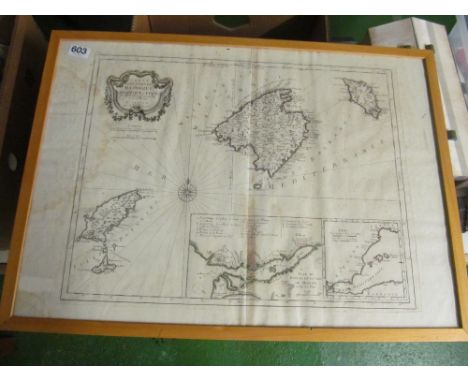


Lot 302
A collection of antique maps, comprising 'Western part of the Roman Empire', 47 by 40cm, glazed and framed, 60 by 54cm, 'A Map of Britain according to the Notitia Imperii', hand coloured, 24.5 by 25cm, glazed and framed, 32 by 40cm, 'Eastern part of the Roman Empire', 43 by 41cm, glazed and framed, 'Northamptonshire' by H. Moll, 32 by 20cm, glazed and framed, 49 by 38cm, 'Huntingdonshire' by H. Moll, 20 by 32cm, glazed and framed, 51 by 37cm, 'Huntingdonshire' by Robert Morden, 37 by 43cm, glazed and framed, 59 by 53cm, 'Rutlandshire', 1830 engraving, hand coloured, 36 by 45.5, mounted but unframed, 49 by 59cm, and a map of 'Britannia Romana', 42.5 by 36cm, mounted, glazed, and framed, 59 by 54cm. (8)


![A 20th century W.& A.K Johnston's limited London map of Europe [90x135cm]](https://cdn.globalauctionplatform.com/d2168f73-c8b2-4cd1-b6dc-b0c400ffe884/25f9fc8b-f4d2-4265-b885-b0c50112c0a0/468x382.jpg)
![A 1654 Lavdelia sive lavderdalia Lauderdale antique Scottish map by Blaeu framed with glass front & back [64x72cm]](https://cdn.globalauctionplatform.com/d2168f73-c8b2-4cd1-b6dc-b0c400ffe884/cbd20ca2-1bce-45a3-b7e5-b0c5011335af/468x382.jpg)


![[Field (Cyril and Herbert Edward Blumberg], Britain's Sea Soldiers, map volume only, 7 folding maps, some tears to folds. The](https://cdn.globalauctionplatform.com/85ed8096-4361-46b6-8370-b07300e2e889/60255630-4014-4e52-b032-b0c8010d6a52/468x382.jpg)


Lot 1048
An 1898 Times Atlas of 118 pages of full colour maps, mostly full and double page, together with eight maps cut from contemporary newspapers about the Boer war, as well as a full page map showing the cost of General Gordon's actions in Sudan along with a Times Atlas of the World 1922 edition with 112 double page colour maps.


Lot 187
LATE GEORGE III NEEDLEWORK MAP OF EUROPE including British Isles, North Africa, Russia and Central Asia, within foliate meandering border with circular medallion, entitled 'Map of Europe, Work by *** Langdale, May 1800', 50 x 60cmsProvenance: private collection CardiffComments: framed and glazed, map faded and worn with some names erased


Lot 2746
Karte des Persischen Reichs "Imperii Persici in omnes suas Provincias...". OriginaltitelAltkolorierter Kupferstich von Johann Baptista Homann, Nürnberg um 1720. Die detailreiche, grenz- und flächenkolorierte Landkarte zeigt den heutigen Iran, Irak, Syrien, den Persischen Golf, das Kaspische Meer sowie Teile des östlichen Mittelmeeres mit Zypern und das Schwarze Meer im Nordosten. Figürliche Titelkartusche mit Leopard und Löwe sowie mit Meilenzeiger. Plattenmaß 49,5 cm x 59 cm. Rahmen.Hand-coloured, copper engraved map of the Persian Empire by Johann Baptista Homann, Nuremberg circa 1720.

Lot 2747
Karte von Afrika "Totius Africae Nova Repraesentatio...". OriginaltitelKolorierter Kupferstich von Johann Baptista Homann, Nürnberg um 1720. Gesamtansicht Afrikas mit angrenzenden Meeren. Figürlich dekorierte Titelkartusche. Farblegende ergänzt. Plattenmaß ca. 49 x 56,8 cm. Rahmen.Hand-coloured, copper engraved map of Africa by Johann Baptista Homann, Nuremberg circa 1720. Colour explanations laid on later.


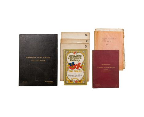
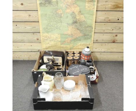
Lot 170
British Railway Ordnance Map Assortment (7) items including a cloth bound accordion fold linen-backed 'Manchester, South Junction and Altrincham' imprinted 'Estate Department Euston Station' on cover, a cloth bound accordion fold linen-backed 'Cheshire Lines Glazebrook to Godley Junction / 6-Inch Ordnance' imprinted 'Surveyor Liverpool' on cover, (3) large folding maps on linen-backed paper marked #5, #6 and #9; together with a folder containing a map of the Wye Valley Railway and an assortment of late 19th century stock option applications for that line and a 1915 'Lancashire & Yorkshire Railway Time Tables' booklet having bound in maps of that line and of Irish lines Property from: The Estate of Thomas ('Tom') Jones, Wilton, Connecticut Height: 16 3/4 inches, Width: 12 1/8 inches, Depth: 3/4 inches (largest, closed) Condition: overall light to moderate wear consistent with normal use, light to moderate soil to covers, may have occasional creases, bent corners, short tears and spots of discoloration Disclaimers: maps not fully opened, loose sheets and documents not individually inspected Category: Collectibles > Railwayana - Maps Estimated Sale Time: 1:38 pm (America/Chicago) Shipping Status: Leonard Auction Shipping Quote Download High Resolution Photographs:Photograph #1Photograph #2Photograph #3Photograph #4Photograph #5Photograph #6Photograph #7Photograph #8
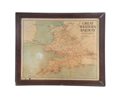
Lot 172
Great Western Railway Tin Map GWR system enamel map, in original oak frame Property from: The Estate of Thomas ('Tom') Jones, Wilton, Connecticut Height: 23 1/2 inches, Width: 29 1/2 inchesFrame Size: 28 inches by 33 3/4 inches Condition: overall light wear consistent with normal use, having scuffs, nicks, chips, missing paint, scratches, tape marks, crazing and fading overall, frame having cracks to wood, loose joints, missing wood Disclaimers: not examined out of frame Category: Collectibles > Railwayana - Maps Estimated Sale Time: 1:39 pm (America/Chicago) Shipping Status: Leonard Auction Shipping Quote Download High Resolution Photographs:Photograph #1Photograph #2
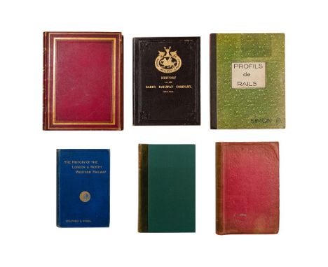
Lot 175
Antiquarian Railway History Books (6) items including 'Railways of Great Britain and Ireland' by Francis Whishaw, London 1840 rebound in gilt-stamped red full Morocco leather having engraved frontis and plates at rear including fold-out maps and diagrams, pertinent print-outs laid in, 'The Rail Road Book of England' by Edward Churton, London 1851 in publisher red cloth having a fold-out map and numerous text cuts, 'The History of the London & North Western Railway' by Wilfred L. Steel, London 1914, cloth, illustrated, 'The Story of the Cambrian' by C. P. Gasquoine, Oswestry 1922, quarter leather, illustrated, 'History of the Barry Railway Company' by R. J. Rimell, Cardiff 1923, cloth, illustrated; together with 'Profils de Rails' French language blueprint index from the Chamiers route workshop providing cross-sections of rails including specifications, cloth backed boards Property from: The Estate of Thomas ('Tom') Jones, Wilton, Connecticut Height: 11 inches, Width: 9 inches, Depth: 2 inches (largest) Condition: overall light to moderate wear consistent with normal use, 'Railways of Great Britain and Ireland' lacks half-title and title page (facsimiles laid in) Disclaimers: individual pages have not been inspected, we cannot guarantee completeness, may have occasional bent corners, creases, short tears, owner names or notations, foxing or discoloration Category: Collectibles > Railwayana - Books Estimated Sale Time: 1:42 pm (America/Chicago) Shipping Status: Leonard Auction Shipping Quote Download High Resolution Photographs:Photograph #1Photograph #2Photograph #3Photograph #4Photograph #5Photograph #6Photograph #7Photograph #8Photograph #9Photograph #10


Lot 164
JOLLIE F. & SONS (Pubs). Cumberland Guide & Directory, Part the First. Fldg. eng. plan & eng. map with hand colouring. Orig. brds., wear & splitting. Carlisle, 1811; also Barnes-Moss' Directory of Carlisle, 1884-5, Bulmer's History & Directory of Cumberland, 1901, Kelly's Directory of Cumberland & Westmorland, 1925, & 2 others. (6).


Lot 193
DUNCAN JAMES (pubs). The Modern Traveller. Mexico & Guatimala, 2 vols., fldg. map & eng., illus., 16mo., quarter maroon morocco, 1825; with similar works re. Brazil & Buenos Ayres (2 vols), Spain & Portugal (vol. 1) & Russia, each with fldg. eng. maps, & another re. Peru & Chile, also with fldg. map. (7)

Lot 259
DARBY WILLIAM. A Tour from the City of New York to Detroit in the Michigan Territory. 3 fldg. eng. maps with hand colouring (one torn). Leather backed brds., worn cond. with foxing & browning. New York, 1819; also Samuel Bowles, Across the Continent, A Summer's Journey to the Rocky Mountains, the Mormons & the Pacific States with Speaker Colfax, fldg. col. eng. map & title vignette, brown cloth, a nice copy, Springfield, 1866. (2).


Lot 267
HUNTER HENRY. The History of London & Its Environs. 2 vols. 1700 plus pp. Subscriber's list. 34 good eng. plates incl. 5 county maps hand col. in outline. Includes supplemental plate at p505 but without plan of London & map of The Country Round London. Quarto. Qtr. calf, rubbing & wear but contents generally very good, marbled edges. Bookplate of O'Grady, Kilballyowen. 1811.


Lot 74
PEARSON HUGH. Memoirs of the Life & Correspondence of the Reverend Christian Frederick Wsartz to Which is Prefixed A Sketch of the History of Christianity in India. 2 vols. Eng. port. frontis & eng. map. Dark maroon morocco, marbled edges, rubbing to backs, top brd. of vol. 1 det. but present. Bookplate of J. W. Marsden. 1834.


Lot 79
SALAMÉ A. A Narrative of the Expedition to Algiers in the Year 1816, Under the Command of ... Admiral Lord Viscount Exmouth. Eng. port. frontis, fldg. eng. map & 2 fldg. eng. plates, one hand coloured. Rebacked half calf, internal damp stng. 1819; also Louis Venillot, Les Francais en Algerie, eng. frontis & plates, half calf, marbled brds., very clean internally, Tours, 1853. (2).


Lot 91
CHAMBERS WILLIAM & ROBERT (Pubs). A vol. of works on travel & explorations, each an Edinburgh imprint with a title page. Howard Malcolm, Travels in the Burman Empire, map, 1840; Howard Malcolm, Travels in Hindustan and China, text vignettes, 1840; Samuel Parker. Journey Beyond the Rocky Mountains, 1841; J. L. Stephens, Incidents of Travel in Greece, Turkey, Russia and Poland, 1839; The Life and Travels of Mungo Park, map, 1838 & Alphonse de Lamartine, Travels in the East, 1839. Royal 8vo. Rebacked quarter calf, marbled edges.
-
109198 item(s)/page