We found 109182 price guide item(s) matching your search

Refine your search

Year

Filter by Price Range
  • List
  • Grid
  • 109182 item(s)
    /page

Lot 2566

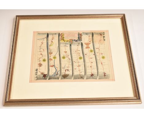
Elsass.: Le Cours du Rhin de Bale a Hert pres Philisbourg contenant l'Alsace er Par. du Brisgau. Kolor. Kupferstichkarte in 5 Blättern. Par Le Rouge, Paris, Augustins, 1745. Ca. 71 x 50 cm (je Blatt), Gesamtgröße: Ca. 70 x 250 cm. Zusammensetzbare Karte (nebeneinander) von Elsass und Pfalz bis einschl. Landau. Für milit. Zwecke angefertigt. Mit 2 figürl. Kartuschen u. Insetkarte von Basel. Gut erhalten, Kl. Läsuren am weißen Rand. - Coloured copper engraving map in 5 sheets. Side by side composable. Small damages on the margin.

Lot 1262

(Pecht,J.).: Ansichten vom Bodensee und seinen Umgebungen. Text- und 2 Tafelbändchen. Konstanz, Pechtische Steindruckerei (1832). Qu.kl.8°. Mit 2 lith. Titeln, 101 lith. Tafeln u. 1 lith. Karte. 3 Bl., S. 7-136. Hldrbde. d. Zt. Schefold, vgl. S. 30 u. 274. - Zählt alle Ansichten auf und bildet 3 davon ab. - "...schuf P. in seinem lithogr. Bändchen des Ober- und Untersees einen Zyklus, der in einer bis dahin nie durchgeführten Vollständigkeit und Reichhaltigkeit fast alle nur irgend wichtigen Orte, Klöster und Schlösser am ganzen See in biedermeierlichen Treue und Auffassung in hundert (101) kleinen Prospekten im Bilde festhielt". - Selten. - Rare. 3 volumes. With 2 lithographed titles, 101 lithographed plates and 1 lithographed map. Contemporary half leather.

Lot 232

A mounted limited edition pure silk scarf made exclusively for The Dulwich Picture Gallery Edward Bawden exhibition, features a detail from a  Map of the British Empire Exhibition (1924) by Edward Bawden and Thomas Derrick. H.87 W.103cm

Lot 517

An early map of Glasgow and surrounding areas, framed and glazed, 55 x 65cm overall Condition Report: Available upon request

Lot 518

An early map of Lennoxtown, framed and glazed, 55 x 65cm overall Condition Report: Available upon request

Lot 136

Forster (E.M.) Alexandria: a History and a Guide, first edition, signed presentation inscription from the author to endpaper, maps and plans, including folding map in pocket at rear, light browning and ink ownership inscription of Islay de Courcy Lyons to front free endpaper, original boards, browning to spine, spine chipped at head and bumped at foot, light rubbing browning to covers, [Kirpatrick A8a], 8vo, Alexandria, Whitehead Morris, 1922.⁂ A rare Forster title, especially inscribed - many copies were destroyed by fire. Alexandria was an important city for Forster: he spent much of the First World War there working for the British Red Cross and it was the city in which he was first able to express his homosexuality. This one of the copies with the plan for p.144 placed at p.44. Algernon Islay de Courcy Lyons (1922-1993), Welsh photographer and novelist. See also lots 190, 196, 197, 201, 204 and 205.

Lot 137

Forster (E.M.) Alexandria: a History and a Guide, number 9 of 250 copies signed by the author, plates, maps and plans, some folding, including folding map at read, the odd spot or patch of foxing, light browning to endpapers, original orange boards, light sunning to spine, spine ends and corners a little bumped, light rubbing, [Kirkpatrick A8b], 8vo, Alexandria, Whitehead Morris, 1938.⁂ The second, much revised edition, published under the auspices of Royal Archaeological Society of Alexandria.

Lot 255

Hughes (Langston, editor) An African Treasury, first edition, signed presentation inscription from the author to Kwame Nkrumah dated 1960 to half-title, map endpapers, original cloth-backed boards, light wear to tips of spine and corners, dust-jacket, price-clipped, discolouration to spine, a little chipped at head and foot, light marking and surface soiling, extremities rubbed, 8vo, New York, Crown, 1960.⁂ An excellent association copy, inscribed to the first President of Ghana and father of African independence in the Gold Coast. whose speech to the U.S. Senate is featured on pp.75-6. Hughes travelled through the Gold Coast as a young man and was a strong advocate for African independence as evinced by the present work.

Lot 268

Isherwood (Christopher) and W. H. Auden. On the Frontier, signed by Isherwood on title, publisher's review slip loosely inserted, some light toning to margins, light browning to spine, jacket with light creasing to spine, some short tearing to joint ends, light creasing to head, light toning to panels, [1939]; Journey to a War, signed presentation inscription from Isherwood dated December 1941 to endpaper, colour frontispiece, illustrations, map endpapers, light fading to spine, minor fraying to spine ends and corners, jacket with light browning to spine and lower panel, light chipping to spine ends and corners, an excellent copy, 1939, first American editions, original cloth, dust-jackets, excellent copies, [Westby and Brown p.26], New York, Random House, 8vo (2)

Lot 7

NO RESERVE Auden (W.H.) and Louis MacNeice. Letters from Iceland, first edition, signed by Auden on front free endpaper, plates and illustrations, folding map, some light spotting, Group Theatre flier loosely inserted, original cloth, light discolouration to spine and covers, dust-jacket, light browning to spine and panels, spine ends and corners chipped, creasing to head and foot, 8vo, Faber & Faber, 1937.

Lot 513

Blaeu'Sussex', engraving, the upper border with Royal Crest and coat of arms, hand-coloured, 39 x 53cm; and one further - Map of Holy Island, 39 x 48cm (2)

Lot 514

An Oxford Plastic Relief Map, Series 6 Map, titled 'The Oxford District', 97 x 67cm

Lot 521

J Hinton'An accurate map of England, Scotland and Ireland', engraving, hand-coloured, 36 x 26.5cm; and a 19th century engraved map of South America, the former unframed (2)

Lot 525

John SpeedeA New and Accurate Map of the World, engraved double hemisphere map decorated with vignettes for the four elements, solar and lunar eclipses, celestial hemispheres and explorers, un-coloured, Bassett & Chiswell, 40 x 53cm

Lot 527

Matteus Seutter'Portugallia et Algarbia Regna', engraving with decorative title, cartouche and inset map of Brazil, hand-coloured, 51 x 59cm

Lot 530

R.W. Seale'A map of North America', and 'A map of South America', engravings, two, each with decorative ornamental scrolling foliate title cartouche, 39 x 47cm and 48 x 38cm (2)

Lot 531

T Jefferys (pubs)'Extract from several authentic letters from Berlin giving an account of the battle fought between the Prussians and Austrians, near Prague, May 6, 1757' text, together with 'A map of the County Round Prague' and 'A plan of the City of Prague all on one sheet', hand coloured, 61 x 48cm (SL)

Lot 186

A reproduction map of Glamorgan together with a large quantity of pictures, prints and mirrors

Lot 348

Royal Air Force Air Crew Silk Map of Far East Interest, mint condition double sided aircrew issue map of Borneo and Sumatra etc.

Lot 400

WW1 German 1917 Map of Belgium, interesting map of a scale 1:100,000, produced for the German 4th Army (4.Armee). Marked to the top “Geheim” meaning secret. Map shows the positions of the British, French and Belgium forces. Also shows the German positions etc. Some fold marks and wear but generally still a good example.

Lot 692

WW2 British Fairbairn Sykes (F.S) Commando Dagger & Paperwork Grouping of Operation Infatuate Interest, being a standard 3rd pattern commando knife with ribbed blackened brass one piece grip, top pommel stamped “4”. Plain oval guard. Double edged stiletto blade retaining much of the original blueing remaining. Housed in the original leather scabbard with blackened brass lower chape. Accompanying the dagger is a file of paperwork belonging to the original owner, including a large folding map case / board, Air Ministry produced panorama intelligence planning photographs of the Dutch islands which were attacked during Operation Infatuate, various wartime and early post war publications, interesting grouping of maps relating to various areas of Holland including Arnhem. Sadly we have not been able to find any name to the grouping. All came to the current vendor together.

Lot 167

A 18th Century framed, glazed and mounted coloured bookplate by John Speed, a map of Stafford and the surrounding area, the reverse with a list of all memorable places in Staffordshire, including towns, rivers etc. and additional information 64cm x 77cm 

Lot 168

A framed map of Staffordshire by Joseph Browne (1682) taken from Dr R. Plots Natural History of Staffordshire c. 1686, the map surrounded by Towns Crests (has come lose on mount) 85cm x 75cm.

Lot 171

Robert Morden (British, 1650-1703) A Map of Staffordshire, hand coloured engraving, framed and glazed 66cm x 56cm

Lot 771

Various ephemera, Twain (Mark) A Dog's Life, bygone newspapers, other ephemera, motor electrical manual, map of central London, various other folding maps, and ephemera. (a quantity)

Lot 352

A large collection of vintage and recent tools and collectables, some of military interest, including three inter-war 120 rollfilm cameras, various multi-tools, military issue map tools, two vintage tape measures, a group of folding pocket knives, a diving knife with sheath and other knives, mid-century and later petrol lighters, riding stirrups and spurs and other items (a lot).Condition report: Due to the quantity of items in this lot it is presented 'as found'. Please refer to images.

Lot 703

A keith Melling signed print Great Langdale; a print of a map of lancashire and a watercolour (unsigned)

Lot 325

A silver compact, c1930, the lid engraved with a map of India divided into its provinces, 72mm

Lot 224

The History of The Jews from the Time of Nehemiah to the Destruction of Jerusalem, by the Romans Under Titus Vestasian being an Appendix to the Sacred History in Sixteen Letters by a Lady printed for T. Gardiner 1796 with folding map bound in leather with gilt bands

Lot 227

[Deluxe First Edition] A.A. Milne Winnie-The-Pooh with Decorations by Ernest H. Shepard published Methuen 1926, first edition deluxe copy bound in full leather with gilt vignette and borders front cover and gilt decorated spine with lettering, map on endpapers    

Lot 239

[First Edition] A.A. Milne Winnie-The-Pooh with decorations by Ernest H. Shepard, published Methuen 1926 first edition with map drawn endpapers and in publisher’s original gilt cloth

Lot 460

John Ogilby framed double sided road map from Bristol to Ludlow and Bristol to Banbury, 24 x 31cm

Lot 484

A collection of vintage maps and ephemera including Bacon's New Survey Map of Somerset, Dorset, Wiltshire, illustrated books on Chipping Sodbury and Cirencester, The Royal Road, Book of England, various motoring and touring maps and including Lyndhurst district map for cyclists and motorists, Bacon's Henley, Windsor, Sherborne maps, Atlas guide to London suburbs, aeronautical and military maps

Lot 487

A Arrowsmith map of the countries lying between Euphrates and Indus on the East and West and the Oxus and Terek and Indian Ocean, on the North and South, inscribed to Brigadier General Sir Malcolm Knight of the Royal Persian Order of the Lion and Sun, by John Macdonald Kinneir, dated January 1813, 98.5cm x 130cm

Lot 156

Four framed prints and a map (5) Condition Report: Available upon request

Lot 88

A map table with brass edges showing areas of Scotland, 41cm high x 89cm wide x 61cm deep Condition Report: Available upon request

Lot 936

A FRAMED VINTAGE MAP OF LANCASHIRE

Lot 1017

A VINTAGE FRAMED MAP YORKSHIRE

Lot 388

Vietnam War Era N.V.A ? Vietcong Map Case. P&P Group 2 (£18+VAT for the first lot and £3+VAT for subsequent lots)

Lot 405

GOOD ANTIQUE HAND COLOURED MAP OF DEVONSHIRE TOGETHER WITH LATER MAP OF SUSSEX WITH PRESENTATION PLAQUE

Lot 437

F/G MAP OF SOUTH DEVON SHIP WRECKS & RECTANGULAR ADVERTISING MIRROR FOR OGDONS ROBIN CIGARETTES

Lot 165

John Speed, 'Cardiganshyre', an original sparsely coloured map with vignette and crests. Framed and glazed. (B.P. 21% + VAT)Some discolouring and foxing spots, overall creased. Mount close to plate mark. Not double glazed. 

Lot 166

John Speed, 'Shropshyre', an original later coloured map, Basset & Chiswell edition. 38 x 51cm approx. (B.P. 21% + VAT)Foxing spots overall and some discolouring. Creased. Mounted close to plate mark. Not double glazed. 

Lot 181

John Speed, original map of 'Pembrokshyre', sparsely coloured with vignettes. 39 x 52cm approx. Modern glazed frame. (B.P. 21% + VAT)Some foxing overall and rather discoloured. Modern frame. Not double glazed.

Lot 454

OLD ORIGINAL MOTORISTS MAP OF IRELAND ISSUED BY J.B.FERGUSON LTD, CHICHESTER STREET, BELFAST

Lot 425

RAILWAYANA COLLECTABLES & EPHEMERA - London and North Western Railway service badges, Points keys, L & NWR advertising ashtray for The English Lake District, London, Midland & Scottish Railways Company headed paper, diaries, address and notebooks, mainly blank, a further quantity of leather wallets for LMS, L & NWR, London and North Western Railway Rules and Regulations for the Conduct of The Traffic 1847, Harry R G Inglis contour road map of England Northern Division with diagrams and maps, 1900, Bradshaw's General Railway, Steam Navigation and Hotel Guide No 1251 September - October 1937, The ABC Alphabetical Railway Guide July 1937, unused envelopes and other interesting items

Lot 109

Large green pottery jardiniere, two oil lamps, carriage lamp, pair of glass decanters and glasses, wood figures, framed map of Suffolk, vintage Ordnance Survey maps, assorted china, etc.

Lot 184

A framed reproduction Blaeu wall map together with four other maps of the British Isles.

Lot 187

A RARE NEEDLEWORK MAP SAMPLER LATE 18TH CENTURY depicting 'A Plan of Kites Nest Farm in the Parish of Ore in the County of Sussex', with the meadows and fields delineated and listed 'The Contents from Stem to Stem' with individual and total acreages, with neighbouring lands listed and titled 'Late Mrs Beals Land', 'Mr Christopher Thorpes Land', 'Edward Milward Esquire DQ' and various foothpaths, including 'Lane to fighting cocks', in a glazed bird's eye maple frame 50 x 47cm Provenance 'A Lifetime of Collecting' - The Property of a Gentleman.

Lot 343

'CORNWALL' AN ENGRAVED MAP BY JOHN SPEED (1552-1629) a hand-coloured engraved map with an inset view of Launceston, inscribed 'Are to be sold by Thomas Bassett in Fleet Street and Richard Chiswell in St. Paul's Churchyard', dated '1610' but probably later, c.1676, English text to verso, in a later glazed oak frame 39.5 x 52cm Provenance From the collection of Edward Croft-Murray CBE (1907-1980).

Lot 344

'HEREFORDSHIRE' BY JOHN SPEED (1552-1629) a black and white engraved map, with an inset map of Hereford, inscribed 'Performed by John Speed and to be solde by Henry Overton at the White Horse without Newgate London, in a later glazed bird's eye maple frame, together with a hand-coloured engraved map of Cornwall by Blaueu, titled 'Cornubia', with Latin text to verso, in a later glazed oak frame (2) 43.8 x 55cm (max) Provenance From the collection of Edward Croft-Murray CBE (1907-1980).

Lot 68

A Victorian papier-mâché mother-of-pearl inlaid box, containing a collection of bone spillikins and playing cards, 5.5cm x 17cm; an ebony ring tree with small silver plaque, 9.5cm; an Eastern Telegraph Company Ltd wooden paper turner, 1892 calendar to handlem part map of the world on paddle, 33cm; mauchline-type boxes; and other treen items.

Lot 79

Fifteen coloured engravings depicting locations in Scotland, eight others and a map of Northumberland, (24).

Lot 238

Robert Morden, hand coloured map of Essex, framed and glazed, 36 x 42cmCondition report: Slight browing to paper

Lot 502

Ten small painting and prints, including two small flower studies by Pearl Titterington, a small road map print and others (10)

Lot 287

An annotated and coloured map of England, framed and glazed, together with and an aerial survey of St Clair, framed, 54cm x 82cm

Lot 539

Map of the County of Northmberland from a survey by C &J Greenwood, framed and under glass, 69 x 71cms; with a map of Northumberland; and a plan of Hexham from a survey 1826, each framed and under glass. (3)

Lot 304

A vintage wall map Bacon's 20th Century Map of Northumberland and Durham; and another vintage map by George Philip and son, Ltd, Europe After the Congress of Vienna, 1815. (2)

Lot 9243

Box with map stamps and wooden box with wooden colored blocks and box with various games

Lot 1741

Folder with 3 screenprints: Shunyam, Cecile van der Heiden 2xMap met 3 zeefdrukken, Shunyam en Cecile van der Heiden 2x

Loading...Loading...
  • 109182 item(s)
    /page

Recently Viewed Lots