We found 109198 price guide item(s) matching your search
There are 109198 lots that match your search criteria. Subscribe now to get instant access to the full price guide service.
Click here to subscribe- List
- Grid
-
109198 item(s)/page


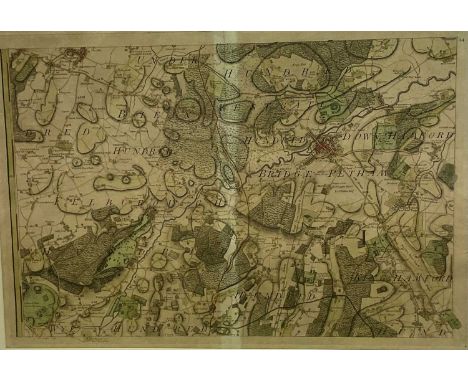
Lot 298
Map of the Nile from the Equatorial Lakes to the Mediterranean, embracing the Egyptian Sudan, (Kordofan, Darfur, & c.) and Abyssinia. Published by Edward Stanford [55 Charing Cross, London, 1884]. Watercolour-tinted engraved map, dissected and laid of cotton, cloth covered boards with printed label.
![CISPIN, EDMUND. The Moving Toyshop by Edmund Crispin. Victor Gollancz Ltd [London, 1946]. The Moving Toyshop. A New Detective](https://cdn.globalauctionplatform.com/475a4e8b-c3b5-41b7-8b3b-b1290097f727/38f2a5c6-b577-47a9-b4b3-b149011d4250/468x382.jpg)
Lot 438
CISPIN, EDMUND. The Moving Toyshop by Edmund Crispin. Victor Gollancz Ltd [London, 1946]. The Moving Toyshop. A New Detective Story by Edmund Crispin author of The Case of the Gilded Fly, Holy Disorders. First Edition, map illustration, original cloth dust jacket, some areas of deterioration to spine of jacket (as often expected). An attractive copy of this classic work of detective fiction, dedicated to Philip Larkin.
Lot 810
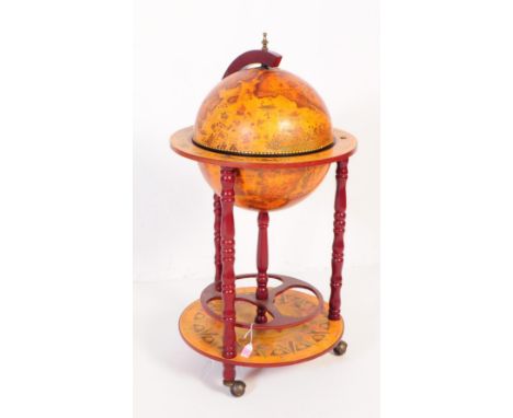
A 20th Century vintage mahogany veneer zodiac globe cocktail drinks cabinet / trolley. Having a hinged lid to globe top, opening to reveal cocktail cabinet interior. The globe decorated with transfer printed map, encompassed by a rounded shelf showing zodiac motif depictions. Raised on turned columns with rotating bottle rack to base, terminating in castors to base. Measures approx. 90x47x47cm


Lot 1478
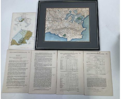
Five maps of interest to the United States and Canada to include, an untitled map depicting New York, 7cm x 12cm, 'Canada', with an inset map titled, 'Part of New Brunswick and Nova Scotia', published by Virtue, 20cm x 25cm, 'Map of New York', published and engraved by Fenner Seara and Co, 26cm x 40cm, 'United States', published by J. Arrowsmith, 15cm x 14cm, all four maps framed and glazed, and together with a unframed but mounted map of 'West Canada' engraved by J. Rapkin, 25cm x 34cm (5)


Lot 1476
W. H. TOMS (1700-1765), 'A Map of Northamptonshire, North from London', Sept. 29, 1742, 17cm x 18cm, together with five double sided maps, each 19cm x 14cm, by, EMMANUEL BOWEN & JOHN OWEN titled, 'The Road from Oxford to Salisbury', numbered 221, and 'The Road from Ferrybridg to Borobridge', numbered 256, all three coloured, and 'The Road from Oxford to Chichester', numbered 215, 'The Road from Cambridge to Coventry', numbered 157, and 'The Road from Prestain to Carmarthen', each uncoloured (6)


Lot 1470
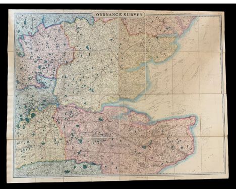
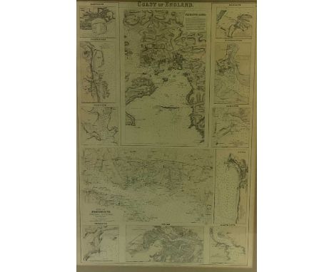
A framed map titled the 'Coast of England', with inset plans for 'Plymouth Sound', 'Ramsgate', 'Folkestone', 'Falmouth', 'Margate, 'Southampton', 'Exmouth', 'Portsmouth, Portsea, Spithead and Vicinity', 'Dover', 'Penzance', 'Poole', and 'Dartmouth', 48 x 31cm, together with JOHN JAMES DOWER (1825-1901), 'Environs of Southampton', undated, both maps coloured, framed and glazed (2)


Lot 1463
THOMAS KITCHEN (1718-1784), 'A New and Accurate Map of that District of Great Britain called England and Wales', uncoloured, 38 x 34cm, together with four county maps by J. ARCHER, comprising 'Surrey' 19 x 24cm, 'Staffordshire', 24 x 19cm, 'Shropshire', 24 x 19cm and 'Northamptonshire', 19 x 24cm, all unframed (5)

Lot 1477
Three double sided maps by EMMANUEL BOWEN & JOHN OWEN, to include number 63, with number 64 verso, 'The Road from Shaftesbury to Exeter', number 263, with number 264 verso, showing Winchester, Alresford, Romsey, Ringwood to Southampton, each map mounted, number 155, with number 156 verso, 'The Road from Bristol to Weymouth', and together by different cartographers a map of 'Dorsetshire', with text to the underneath and verso, 32cm x 24cm, a map of 'Huntingdonshire', engraved for Moule's English Counties by W. Schmolhinger and twenty-five JOHN PLAYER & SONS cigarette cards depicting areas in England, Wales, Scotland and Ireland


Lot 11
WWI Military Medal trio and ephemera; a Military Medal awarded to 65502 Bombadier J Todd 135 Siege Battery, Royal Garrison Artillery, also with the British War Medal and the Victory Medal, included are sweetheart silks, gifts from France, correspondence from officers and friends of Mr J Todd, many photos of him and his comrades prior to active service and whilst on active service, a trench map of France sheet 51b NW edition 9.Cap badges, collar dogs and buttons, his regimental tie and many other interesting items of the period. Provenance: On Friday the 18th January 1918 in Xlll Corps Routine Orders line 1342 reads Honours and Awards: The Corps Commander has awarded the Military Medal to 65502 Bombardier J Todd, RGA for Gallantry and devotion to duty in repeatedly repairing and maintaining telephone lines under heavy hostile shell fire.135 Siege Battery saw action at the Battle of the Somme, Battle of Arras, The German Spring Offensive, and the Hundred days offensive. The Garrison's Headquarters was in Tynemouth and they deployed to the Western Front in the Summer of 1916.Mr J Todd survived the war and was able to represent his unit at wreath laying ceremonies which can be seen in some of the photographs included in this lot.


Lot 1429
Two framed sea charts, 'To the Right Honourable Thomas Earl of Pembrooke and Montgomery Baron Herbert of Sherland and Co... Executing the Office of Ld. High Admiral of England amd Co, And one of their Majesties Most Honourable Privy Council. This is most humbly Dedicated and Prefented by Capt. Greenville Collins', the maps show Plymouth with an inset map of Salcombe, framed, and another of the Devon coastline to include Torbay, with an inset view of the King William landing on the 5th November 1866, framed and glazed, each 34cm x 43cm (2)


Lot 113
A WHITE METAL CIGARETTE CASE AND PHOTO FRAMES, the cigarette case engraved depicting the Taj Mahal India, and a map, set with small red pastes, push button clasp, gilt interior fitted with a single yellow elasticated strap, stamped 'Sterling Silver', approximate gross weight 144.4 grams, together with two silver plate photo frames, and a golfing photo frame unmarked with missing stand to the reverse
Lot 504
TWO BOXES OF GLASSWARE, CERAMICS, CHRISTMAS DECORATIONS, HOUSEHOLD ITEMS AND THREE LOOSE PICTURES, including two loose Jasper Conran for Stuart Crystal shot glasses, a Wedgwood Clio pattern trinket box and cover, a Poole pottery footed dish with abstract decoration, some staining verso, a Soundcore Flare Mini Bluetooth speaker with charger, a small quantity of decorative copper, two 1970's/80's gilt framed landscape oils and framed map of the world pin board, etc (2 boxes + 3 pictures)

Lot 531
SCIENTIFIC AND TECHNICAL INSTRUMENTS ETC, to include a Meiji SKT-2BT binocular microscope in a wood and glass case, a nightwatchman's clock with keys in a wood and Perspex case, a brass Army & Navy rolling ruler in a wooden case, a Lister-Morton Ophthalmoscope in leather bound box, a box of Pyrex test-tubes, a TEC brass and leather torch, two map measures etc

Lot 599
A COLLECTION OF MAPS RELATING TO STAFFORDSHIRE ETC, to include a large Emanuel Bowen map dedicated to Earl John Gower, approximate size 70cm x 54cm including visible margins, Robert Morden 1772 issue map, William Kip 1637 issue map, John Speed 1631 issue map with Lichfield and Stafford towns inset to top corners, William Hole map produced for Michael Drayton's poem Polyolbion, John Bill map published in the Abridgment of Camden's Britania' 1626, various other maps of Staffordshire, a map of the Universe by Antoine Francois Prevost and a map of The British Isles by Sebastian Munster

Lot 712
Abraham Ortelius (Belgian, 1527-1598), hand-coloured map, Anglia, Scotiae et Hiberniae Sive Britannicar, Insularum Descriptio, inscribed ‘Carte Anno 1572’ to the margin in pencil, 37 x 52cm Fragile, dirty and with several creases around margin; three corner torn and incomplete; centre fold fragile with tears. Frame poor; non-reflective glass. ,

Lot 297
Erik Nitsche (Swiss, 1908 - 1998) "City Map with Dividing Lines" Signed lower left. Original Mixed Media on Illustration Board. Provenance: Collection of James A. Helzer (1946-2008), Founder of Unicover Corporation. The Universal Postal Union, a specialized agency of the United Nations, was established to improve postal service throughout the world by ensuring international collaboration. At the beginning of the 19th century, postal relations between nations consisted of a bewildering array of bilateral treaties, which were further confused by a diversity of currencies and units of weight. Postal charges were largely calculated by distance traveled. In addition, the recipient of the letter, rather than the sender, was responsible for expenses incurred! In 1837, British educator and reformer Rowland Hill first proposed charging a single uniform rate for mail delivery, based on weight rather than distance, and the use of prepaid postage stamps. On September 15, 1874, representatives of 22 countries met at the first International Postal Congress to sign a "Treaty concerning the Establishment of a General Postal Union." This organization became responsible for the adoption of uniform postal rates and units of weight between all member nations. In 1878, the second International Postal Congress was held and the body's name was changed to Universal Postal Union (UPU). On July 1, 1948, the UPU became a specialized agency of the United Nations. Over the years, the UPU has extended its functions to cover other international services provided by postal administrations, including money orders, parcel post, postal checks, cash on delivery and savings banks. Image Size: 12.25 x 18.25 in. Overall Size: 17.5 x 20 in. Unframed. (B08810)
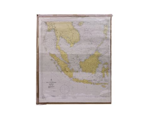
Lot 87
A LARGE INDONESIAN MAP OF SOUTH-EAST ASIA Kepulauan Indonesia Dan Sekitarnya, originally published 1961, with revisions 1988 and 1997 110 x 91cm Condition: For a condition report or further images please email hello@hotlotz.com at least 48 hours prior to the closing date of the auction. This is an auction of preowned and antique items. Many items are of an age or nature which precludes their being in perfect condition and you should expect general wear and tear commensurate with age and use. We strongly advise you to examine items before you bid. Condition reports are provided as a goodwill gesture and are our general assessment of damage and restoration. Whilst care is taken in their drafting, they are for guidance only. We will not be held responsible for oversights concerning damage or restoration.

Lot 88
A LARGE MAP OF THE SINGAPORE STRAIT 1974, Singapore Strait: Principally From British Admiralty Surveys, 1865-1930, and Netherlands Government Charts to 1934 114 x 66cm Condition: Condition Report Slight damage to frame and small crack/split in perspex front. This is an auction of preowned and antique items. Many items are of an age or nature which precludes their being in perfect condition and you should expect general wear and tear commensurate with age and use. We strongly advise you to examine items before you bid. Condition reports are provided as a goodwill gesture and are our general assessment of damage and restoration. Whilst care is taken in their drafting, they are for guidance only. We will not be held responsible for oversights concerning damage or restoration.


Lot 525
An early A3 Ordnance Map, J. E. Cornish, Little Lever and surrounding areas together with an interesting collection of ephemera relating to the sale of parts of the Alderley Park Estates, Cheshire in 1940. Also included is an Auction Catalouge for the 'Estate at Styal' (Parish of Wilmslow) 1877. (Qty) In good original antique and vintage condition.


-
109198 item(s)/page