We found 109198 price guide item(s) matching your search
There are 109198 lots that match your search criteria. Subscribe now to get instant access to the full price guide service.
Click here to subscribe- List
- Grid
-
109198 item(s)/page


Lot 541
1720 Map of North America by Henry Abraham Chatelain. A hand-coloured, engraved map, Nouvelle Carte de l`Amerique Septentrionale, by Henry Abraham Chatelain, chart to the right lists the primary divisions of North America with colonial interests, native tribes, and towns. 18 by 24in. (45.7 by 61cm)

Lot 686
Wright, G.N. A Guide to the County Wicklow Illustrated by Engravings, after the designs of George Petrie, esq, and a large map of the County from an original survey. Baldwin, Cradock and Joy, 1822., 159+8 pp. 17.5 x 11 cm. Large folding map, and 5 plates. Five plates are called for and are present: Killruddery House, Powerscourt Waterfall, Drumgoff Barrack, Glendalough, and Luggala. The map is engraved by Sydney Hall from an original survey for Baldwin Cradock and Joy, London October 15th, 1822. MAPS


Lot 573
Bartlett, W. H. The Scenery And Antiquities Of Ireland and Halls' Ireland: Its Scenery, Character, &c. The Scenery And Antiquities Of Ireland illustrated From Drawings By W. H. Bartlett; The literary portion of the work by N. P. Willis, And J. Stirling Coyne. Two volume set. London: Virtue and Co., (circa 1880). 4to, quarter green calf with gilt borders on front & rear covers. Spine gilt and with raised bands, illustrated title pages, full-page map, and 118 full-page captioned engravings; together with one volume of Halls' Ireland: Its Scenery, Character, &c., Cork, Kerry and Waterford. (3)
Lot 118
A vintage police truncheon, of plain wood design with turned handle, stamped C1106 to base of stem ,47cm long, together with an oak side table with barley twist legs, 72cm high, a Victorian clock, a box of ebony & ivory dominoes, a large oak box, a small wooden cigarette box and a vintage road map of Great Britain etc (8)

Lot 1763
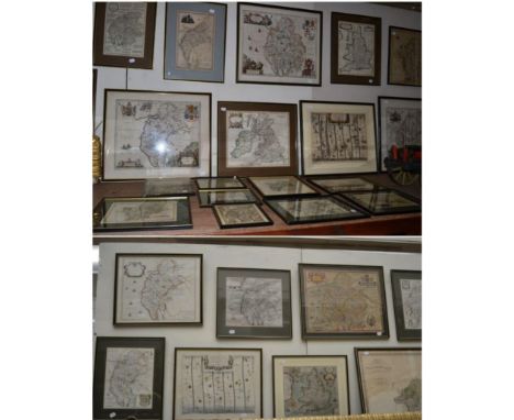
A FINE COLLECTION OF ANTIQUARIAN MAPS OF CUMBRIA AND WESTMORLAND Forming an impressive cartographic record of the region c.1650-1850, by some of the most famous map makers; single sheets (often double-page), 8vo to large folio size, in generally good condition, and in most cases with contemporary or early hand colouring: Saxton (Christopher) Cumbria sive Cumberlandia, engraved by William Kip with early hand colour for Camden's Britannia [1607], Latin text to verso; Blome (Richard), A Generall Mapp of the Countie of Cumberland [&] A Mapp of the Countie of Westmorland, 1672, with a combined 'Generall Mapp' of both counties of the same period (Blome also?); Blaeu (Johannes) Westmoria Comitatus Anglice Westmorland [&] Cumbria vulgo Cumberland [c.1645 or later], both with Latin text to verso; Jansson (Jan) Cumbria & Westmoria vulgo Cumberland & Westmorland [c.1650], Dutch text to verso; Morden (Robert) Cumberland, [1695 or later], Swale and Churchill; also a stained large Westmorland published by Greenwood 1830 (eng. J. & C. Walker), plus a quantity of smaller maps from well-known 18th and 19th century publications by Cary, Kitchin, Pigot, etc. (some reduced versions/copies of earlier maps), with a map from an unidentified German atlas, plus a reproduction of Saxton's 1576 Westmorland map [with:] strip road maps from John Ogilby's Britannia (1698 edition?), some plates from the reduced Ogilby by John Owen and Emanuel Bowen [1720], with the two relevant county maps from the same volume; some road maps from later guides, some tables of travelling distances, often with armorial embellishments and a Map of the Black Lead Mines, 1751, for the Gentleman's Magazine Lot includes four British Isles maps, including Hole (William) Englalond Anglia Anglo Saxonum Heptarchia, [c.1637], early hand colour; Morden's Britannia Romana [&] Britannia Saxonica (engraved by J. Sturt) [c.1700] and Burghers (Michael) Britannia Saxonica, [c.1715]. Framed and glazed (verso glazed in some cases), a few smaller mounted or loose sheets (approx. 57)
Lot 1766
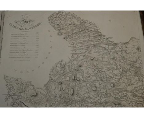
Greenwood (Christopher) Map of the County of York… by Order of The Honourable Board of Ordnance… Surveyed in the Years 1815, 1816 & 1817… 1817, 1817, Leeds, Robinson, Son & Holdsworth, Wakefield, J. Hurst & C. Greenwood, First edition of this large-scale map engraved by S.J. Neele, printed on nine sheets, with altitudes of principal mountains upper left; each sheet c. 680 x 820mm. Minor spotting and staining, a good copy WITH PUBLISHER'S ORIGINAL BUFF WRAPPERS WITH TITLE LABEL PRESERVED. A must-have survey for the map collector and an impressive production, combining accuracy, historical interest and decorative appeal
![Valk (Gerard) and Schenk (Pieter) Middelsexiae cum Hertfordiae Comitatu: Midlesex [sic] & Hertfordshire [with London], [c.17](https://cdn.globalauctionplatform.com/ebefb55c-ec6b-4f41-9ed9-a762009cbfcd/52d50c71-b87f-439d-99b0-051e426b83ca/468x382.jpg)
Lot 1781
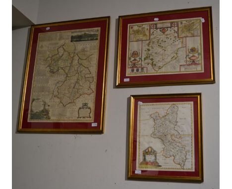
Valk (Gerard) and Schenk (Pieter) Middelsexiae cum Hertfordiae Comitatu: Midlesex [sic] & Hertfordshire [with London], [c.1700], Amsterdam, hand coloured engraved map, East-West orientation, with decorative cartouche, royal arms and mileage scale; printed border 430 x 540mm [&] Blaeu (Johannes) Hertfordiae Comitatus vernaculae Hertfordshire [c.1660], Amsterdam, engraved map with hand colouring, stone plinth with arms of the Earl of Hertford lower left, 375 x 495mm, Latin text to verso. Two decorative maps attractively coloured. Unexamined out of gilt frames (2)
Lot 1780
Bowen (Emanuel) An Accurate Map of Cambridgeshire Divided into its Hundreds, Drawn from Surveys, assisted by the most Modern Maps, with variety of Improvements…[c.1780], London, J. Bowles, R. Sayer and Carington Bowles, engraved map with hand colouring, printed border 696 x 515mm; wildfowling scene as title cartouche, dedication to the Earl of Lincoln surmounted by his arms and inset prospect of Ely [&] Speed (John) Rutlandshire with Oukham and Stanford her bordering Neighbour Newely described, [c.1676], Thomas Bassett and Richard Chiswell, hand coloured engraved map, inset town plans of Oakham and Stamford, elaborate strapwork cartouche and mileage scale, printed border 380 x 510mm; English text to verso [with:] Morden (Robert) Buckinghamshire [1695 or later], Abel Swale, Awnsham and John Churchill, 415 x 345mm. Three decorative maps attractively coloured. Unexamined out of gilt frames (3)
Lot 1767
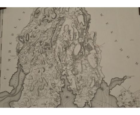
Greenwood (Christopher) Map of the County Palatine of Lancaster, from an Actual Survey; made in the Year 1818, (1818), Wakefield, W. Fowler & C. Greenwood, First edition of this large-scale map engraved by S.J. Neele after R. Creighton, printed on six sheets, with vignette view of Liverpool; each sheet c. 790 x 820mm., soiling, surface scuffs, tatty margins/extremities, one sheet with tears into map from left edge. A must-have survey for the map collector and an impressive production, combining accuracy, historical interest and decorative appeal

![Cary [John] : Cary's British Traveller, with folding engraved map, pub. London 1803, contemporary marbled boards with rebacke](https://cdn.globalauctionplatform.com/336ef012-0517-43a4-9847-a74e00afeb79/e163e976-d725-4e18-91ae-313f2afcaba1/468x382.jpg)


Lot 812
After J & W Emslie, Official Railway Map of the Yorkshire District, dissecting into forty-two sections and mounted on linen, pub. Railway Clearing House, London 1909, gilt morocco covers; Coltman [Nathaniel] : Whittle and Laurie's New Map of all the Coach Roads ...., hand-coloured engraved map, dissecting into twenty-four sections, mounted on linen, New Edition, pub. London 1818, original slipcase. (2)
![Cary [John] : Cary's New Itinerary or an Accurate Delineation of the Great Roads..., third edition with improvements (lacking](https://cdn.globalauctionplatform.com/336ef012-0517-43a4-9847-a74e00afeb79/605b22db-f3a1-4fb2-ada6-bc28a9eb7431/468x382.jpg)

Lot 817
{} A collection of 18th century and Victorian sets of books on British history and family pedigrees, with a Yorkshire emphasis: Neale (J.P.) Views of the Seats of Nobleman and Gentlemen, 1824(-29), London, 5 vols., 8vo, second series, engraved plates, full tree calf gilt; Whitaker (Thomas Dunham) The History and Antiquities of the Deanery of Craven, in the County of York, London, 1805, small folio, plates (incl. aquatints), polished calf with gilt armorials to covers; [Anderson (Adam)] An Historical and Chronological Deduction of the Origin of Commerce, London, 1787, (4 in?) 3 vols, 4to, incl. Appendix, folding map, recent half calf; Morris (Rev. F.O.) A Series of Picturesque Views of Seats of Noblemen and Gentlemen of Great Britain and Ireland, [1879-80], London and Leeds, 7 vols. incl. the rarely found Fac-Simile of Autographs of Subscribers (1880, A. Clarke, with illus. title), 4to, chromolithographic plates, original decorated cloth gilt; Collins (Arthur) The Peerage of England, 1799(-84), London, 9 vols. 8vo, contemporary calf, engraved plates of coats-of-arms; Robertson (William) The History of America, 4 vols., and three other titles by the same author, viz.The History of Scotland During the Reigns of Queen Mary and of King James VI, fourteenth edition, 2 vols.; An Historical Disquisition Concerning the Knowledge which the Ancients had of India, third edition; The History of the Reign of the Emperor Charles V, eighth edition, 3 vols., the ten 8vo vols. uniformly bound in speckled calf gilt, plates and folding maps; The Great Governing Familes of England, 2 vols [together with:] Bogg (Edmund) A Thousand Miles in Wharfdale; Wheater (W.) Some Historic Mansions of Yorkshire, 2 vols.; White (John) Rural Architecture, 1856, Glasgow, Blackie, split folio in original cloth boards [&] vols 5-9 from the Cambridge Natural History, half green calf , plus other odd volumes (qty, 4 boxes)
Lot 769
NORTHUMBERLAND FUSILIERS AND DURHAM LIGHT INFANTRY Mostly large 8vos and 4tos, publisher's cloth decorated with regimental crests where called for: Cooke (C.H., Capt.) Histories of the Northumberland Fusiliers 1914-1919, 1928, Newcastle Chamber of Commerce, the complete set of 4 volumes of Historical Records (of the 9th, 16th, 18th and 19th Battalions), original maroon cloth, one dust jacket preserved; Shakespear (Lt. Col.) A Record of the 17th and 32nd Service Battalions Northumberland Fusiliers (N.E.R.) Pioneers: 1914-1919, 1926, Northumberland Press; Buckley (F., Capt.) War History of the Seventh Northumberland Fusiliers, Newcastle, T.M. Grierson; Historical Record of the Fifth Regiment of Foot, or Northumberland Fusiliers, 1838, London, Clowes & Sons, five coloured plates; ('W.J.B.') A Diary of an Officer with the 4th Northumberland Fusiliers, in France and Flanders, from April 20th to May 24th, 1915, n.d., Hexham, folding map in pocket to rear; Barclay (C.N., Brig.) The History of the Royal Northumberland Fusiliers in the Second World War, n.d., Clowes; Spurgin (Karl B.) On Active Service with the Northumberland and Durham Yeomen n.d., London and Newcastle, a presentation copy signed by the author; Walker (H.M.) A History of the Northumberland Fusiliers 1674-1902, 1919, London, John Murray, half sheep over cloth [with:] Raimes (A.L., Major) The Fifth Battalion The Durham Light Infantry 1914-1918, 1931, published by the Battalion, green sheep, with inscription of Maj. Gen. W.N(?) Herbert of the D.L.I.; Vane (Hon. W.L.) The Durham Light Infantry, 1914, London, Gale & Polden, with 1915 ownership inscription of Capt. J.E. Spedding of the D.L.I. 'in line'; Hardinge Veitch (E., Major) 8th Battalion The Durham Light Infantry 1793-1926, n.d., Durham, J.H. Veitch, folding map in pocket to rear; Lewis (P.J., Major, Compiler) 8th Battalion The Durham Light Infantry, 1949, Newcastle, Bealls; Lowe (W.D., Lt. Col.) War History of the 18th (S.) Battalion Durham Light Infantry, 1920, Oxford University Press; Miles (Wilfrid, Capt.) The Durham Forces in the Field, 1914-18, Vol. II. The Service Battalions of the Durham Light Infantry, 1920, Cassell, 17 illusts., 34 maps and plans [offered with:] Ross of Bladensburg (Lt. Col.). The Coldstream Guards 1914-1918, 3 vols (including Maps), 1928, O.U.P., decorated blue cloth [&] Montgomery (Archibald, Major-General Sir) The Story of the Fourth Army in the Battles of the Hundred Days, August 8th to November 11th, 1918 [1920], London, Hodder & Stoughton, two large 4to volumes (one Maps), in total 100 photographic plates, 19 folding maps, and 9 panoramic folding photographs (5 unbound and issued in Map case), uniformly bound in red cloth gilt, boar's head roundel to upper covers (in total 24 vols in 2 boxes)
Lot 782
THREE ANTIQUARIAN WORKS, SCOTTISH INTEREST Douglas (Sir Robert) Baronage of Scotland containing an historical and genealogical account of the gentry of that kingdon,1789, Edinburgh, sold by Bell & Bradfute et al. folio illustrated with engravings of the coat of arms, contemporary quarter calf [&] Crawfurd (George) Peerage of Scotland...1716, Edinburgh, printed for the author: Sold by George Stewart, folio contemporary calf [with:] Pont (Timothy) Cuninghame Topographised... 1604-1608. With Continuous Illustrative notices by the late James Dobie of Crummock....1876, Glasgow, John Tweed, 4to, original boards, large folding map, plates and text illustrations (3)
Lot 770
BRITISH INDIA: A COLLECTION OF BOOKS Biographies of soldiers and administrators, mostly large 8vos and 4tos, including several first trade editions, publisher's cloth or contemporary leather bindings (rubbed and bumped, some spines faded): Malleson (G.B., Col.) The Indian Mutiny of 1857, 1891, London, Seeley and Co., no. 129 from the Large Paper edition limited to 250 copies, portrait plates, plans, with 1893 presentation inscription, tree calf gilt; Trotter (Lionel J.) The Life of John Nicholson, 1897, John Murray, portraits and maps, red cloth gilt [&] The Bayard of India A Life of General Sir James Outram, Bart., 1903, Blackwood & Sons, red cloth; Curzon (Marquis, of Kedleston) British Government in India, 1925, Cassell and Company Ltd, 2 vols., 4to, blue cloth gilt, two bookplates [&] Leaves from a Viceroy's Note-Book, 1926, MacMillan & Co., 8vo, blue cloth gilt; Kaye (John William) The Life and Correspondence of Major-General Sir John Malcolm, G.C.B., late envoy to Persia, and Governor of Bombay, 1856, Smith Elder & Co., 2 vols., frontispiece portrait, half calf [&] Lives of Indian Officers, 1867, 2 vols., also leather over marbled boards; Thornton (Thomas Henry) Colonel Sir Robert Sandeman: His Life and Work on our Indian Frontier, 1895, John Murray, portrait, map, illusts., blue cloth gilt [&] General Sir Richard Meade and the Feudatory States of Central and Southern India, 1898, Longmans Green & Co., port., maps, illusts., blue cloth; Sandes (E.W.C., Lt. Col.) The Military Engineer in India, 1933(-35), Chatham, Institution of Royal Engineers, 2 vols., frontis., plates, red cloth; Shadwell (Lt. Gen.) The Life of Colin Campbell, Lord Clyde, 1881, Blackwood, port., folding maps, red blindstamped cloth; Colebrooke (Sir T.E.) Life of the Honourable Mountstuart Elphinstone, 1884, John Murray, 2 vols., fifth edition, ports. and maps, green cloth gilt; Marshman (John Clark) Memoirs of Sir Henry Havelock, 1860 [with:] other titles by Malleson, A. Mervyn Davies, H.T. Lambrick, Lord Roberts et al. (total 36 volumes, in 3 boxes)
Lot 192
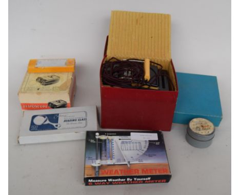
A lot of vintage gadgets, to include a boxed bakelite 'Diaposcope' 35mm colour slide viewer, an Honor Model TE-80 multitester with original instructions, a vintage Paterson contact printer and safelight in original box, an Enbecco Universal Map Measurer and an Enbecco polished aluminium reading glass
![[HISTORY] Parr, Captain Henry Hallam. A Sketch of the Kafir and Zulu Wars. Guadana to Isandhlwana, first edition, Kegan Paul](https://cdn.globalauctionplatform.com/30eb07cd-8147-4807-82c6-a760009b0b14/66228406-407c-4c52-cad2-07a90b7bb619/468x382.jpg)
![[TRAVEL]. NORTH AMERICA Willis, N.P. American Scenery; or, Land, Lake and River Illustrations of Transatlantic Nature, two v](https://cdn.globalauctionplatform.com/30eb07cd-8147-4807-82c6-a760009b0b14/45d64d21-a3df-49b6-bf90-ada7f3516349/468x382.jpg)
Lot 449
[TRAVEL]. NORTH AMERICA Willis, N.P. American Scenery; or, Land, Lake and River Illustrations of Transatlantic Nature, two volumes, Virtue, London, 1840, full dark green leather gilt, vignette half titles, 119 engraved plate illustrations by W.H. Bartlett (66 + 53, as called for), map, quarto (some foxing; covers rubbed; Vol. II with slight wear at spine head).
![[TRAVEL]. SUDAN Slatin Pasha, Rudolf C. Fire and Sword in the Sudan. A Personal Narrative of Fighting and Serving the Dervis](https://cdn.globalauctionplatform.com/30eb07cd-8147-4807-82c6-a760009b0b14/d39adef8-3778-441f-d2c0-4bd63e6ed4cc/468x382.jpg)
Lot 450
[TRAVEL]. SUDAN Slatin Pasha, Rudolf C. Fire and Sword in the Sudan. A Personal Narrative of Fighting and Serving the Dervishes 1879-1895, translated by Major F.R. Wingate, Arnold, London, 1896, original pictorial maroon cloth gilt (hinges tender), top edges gilt, tissue-guarded portrait frontispiece, a further twenty-one plate illustrations, folding plan and folding map (all as called for), thirty-two page publisher's list dated January 1896, quarto.
![[TRAVEL]. MEXICO Hardy, Lieut. R.W. Travels in the Interior of Mexico in 1825, 1826, 1827, & 1828, first edition, Colburn an](https://cdn.globalauctionplatform.com/30eb07cd-8147-4807-82c6-a760009b0b14/dfa7ca0a-1b7f-49b7-c4da-98cc7c193582/468x382.jpg)
![[MAPS] Cary, John (c.1754-1835), 'A Map of Europe', engraved folding map, hand-coloured, linen-backed, corrected to 1824, 13](https://cdn.globalauctionplatform.com/30eb07cd-8147-4807-82c6-a760009b0b14/b7b6beb5-45e2-4779-f86f-80feb64016b8/468x382.jpg)
![[MAPS] Speed, John (1552-1629), 'Wales', engraved map, hand-coloured, sold by 'John Sudbury and George Humble', 40cm x 51.5c](https://cdn.globalauctionplatform.com/30eb07cd-8147-4807-82c6-a760009b0b14/b58bf39b-3dcd-4046-a7fa-c1e9853d5a67/468x382.jpg)
![[MAPS] Speed, John (1552-1629), 'Kent', engraved county map, hand-coloured, sold by 'G. Humble', 40.5cm x 52.5cm.](https://cdn.globalauctionplatform.com/30eb07cd-8147-4807-82c6-a760009b0b14/6702ca52-b622-4ea3-d2a1-09979a75644c/468x382.jpg)
![[MAPS] Speed, John (1552-1629), 'Darbieshire', engraved county map, hand-coloured, sold by 'John Sudbury and G. Humble', 40.](https://cdn.globalauctionplatform.com/30eb07cd-8147-4807-82c6-a760009b0b14/9c25063b-b6bf-4c98-e8c1-b6ec88014859/468x382.jpg)
![[MAPS] Saxton, Christopher (c.1540-c.1610) & Kip, William (fl.1585-1618), 'Cumbria sive Cumberlandia', engraved county map,](https://cdn.globalauctionplatform.com/30eb07cd-8147-4807-82c6-a760009b0b14/b7e992da-e7d7-46e6-f28e-e85610be5c9d/468x382.jpg)
![[MAPS] Speed, John (1552-1629), 'The Countye Palatine of Chester', engraved map, hand-coloured, sold by 'John Sudbury and Ge](https://cdn.globalauctionplatform.com/30eb07cd-8147-4807-82c6-a760009b0b14/81594f1c-2256-4ea0-cee1-8c6c2dcc1799/468x382.jpg)
![[MAPS] Speed, John (1552-1629), 'Caermarden', engraved county map, hand-coloured, sold by 'John Sudbury and George Humble',](https://cdn.globalauctionplatform.com/30eb07cd-8147-4807-82c6-a760009b0b14/460fd770-2365-41b5-b4c8-c58144b54b19/468x382.jpg)
![[MAPS] Speed, John (1552-1629), 'Holy Iland / Garnsey / Farne Iland / Jarsey', engraved map, uncoloured, sold by 'Joh. Sudh.](https://cdn.globalauctionplatform.com/30eb07cd-8147-4807-82c6-a760009b0b14/ccee0de2-e311-47ae-8e2f-e11c92b87b6a/468x382.jpg)
![[MAPS] Morden, Robert (c.1650-1703), 'Dorsetshire', engraved county map, hand-coloured, sold by 'Abel Swale Awnsham and John](https://cdn.globalauctionplatform.com/30eb07cd-8147-4807-82c6-a760009b0b14/d8163c3b-543e-405b-917e-0cb91cfed0ca/468x382.jpg)
![[MAPS] Morden, Robert (c.1650-1703), 'The East Riding of Yorkshire', engraved county map, hand-coloured, sold by 'Abel Swale](https://cdn.globalauctionplatform.com/30eb07cd-8147-4807-82c6-a760009b0b14/5e354b63-9e33-4b31-ba50-ebe38c48e0f8/468x382.jpg)
![[MAPS] Morden, Robert (c.1650-1703), 'Somersetshire', engraved county map, hand-coloured, 36.5cm x 43cm.](https://cdn.globalauctionplatform.com/30eb07cd-8147-4807-82c6-a760009b0b14/96dc19f5-af90-4f35-da92-50b378ee42cc/468x382.jpg)
![Johannes Willemszoon Blaeu (1599-1673) Dutch. "Hvntingdon" [sic], a Coloured Map, 16" x 20.25".](https://cdn.globalauctionplatform.com/b3df6e14-b8eb-4018-89e6-a75401189629/3ba31e1e-2f1d-4a75-912e-b0de15102b2d/468x382.jpg)


Lot 626
A quantity of local ephemera relating to Thomas Sharples to include a photograph of 'T Sharples Grocer' shop front, two full photographic postcards of his family home, 31 Alexandra Road Liverpool and three further notelet postcards, a photograph from the inside of a grocer's store, a photograph of 'Shaw Bros Wholesale Grocers' shop front and further photograph of same shop front with bunting for coronation of Edward VII, two papers relating to Anfield Park Liverpool cemetery including park plot map, a Mason's apron in leather case embossed 'Bro. Thomas Sharples Wilbraham Lodge no.1713'.


-
109198 item(s)/page