![Carte du Canada Dediee a Son Altesse Serenissime Monseigneur [in book] Avantures du Sr. C. le Beau
This charming little map](http://lot-images.atgmedia.com/SR/36385/2906594/108-201458125718_468x382.jpg)

Carte du Canada Dediee a Son Altesse Serenissime Monseigneur [in book] Avantures du Sr. C. le Beau This charming little map of Canada and the Northeast is bound into the first volume of Claude Le Beau`s Avantures du Sr. C. le Beau . The map covers the region from Newfoundland west to Lake Superior and south to the Carolinas. Cartographically, the Great Lakes are fully enclosed but the shorelines are quite distorted. Very little inland information is presented, especially south of the Great Lakes, but Le Beau`s tracks are shown with a dotted line in the present-day region of New York. The map is accompanied by the first volume (of two) of Le Beau`s travels in the area, which includes narratives on the customs of the Iroquois as well as encounters with beavers. Contents include title page, dedication, preface, folding map, two illustrative plates, 370 pp. of text, and a table of contents. Hardbound in full calf with gilt highlights on covers and spine. The map is near fine with faint toning along the edges of the sheet. Contents are clean and tight, the covers show some light wear, and the spine has cracking and minor chips. 6.3 W x 4 H Le Beau, Claude 1738
We found 109182 price guide item(s) matching your search
There are 109182 lots that match your search criteria. Subscribe now to get instant access to the full price guide service.
Click here to subscribe- List
- Grid
-
109182 item(s)/page

Carte de la Nouvelle France, ou se Voit le Cours des Grandes Rivieres de S. Laurens & de Mississipi Aujour d`hui S. Louis... Derived from Nicholas de Fer`s important four-sheet map of 1718, this is the most informative map of the French possessions in North America in the early 18th century. It was issued to promote the recently established Compagnie Francoise Occident, which was formed to fund the debt of Louis XIV and offered inducements to encourage settlement in Louisiana. Louisiana and the Mississippi Valley are based on Delisle`s manuscript map of 1701, while the geography of New England and eastern Canada originates with Franquelin. Inset at top left is a large-scale map of the Mississippi Delta and Mobile Bay, based on the voyage of Pierre Le Moyne d`Iberville. This smaller version is found in atlases published by Ottens and other Dutch composite atlases. There is no engraver or publisher`s imprint. Bold original color with minor soiling at bottom right and one small crack caused by the oxidation of the green pigment, which has been professionally repaired on verso. 19.5 W x 21.6 H Ottens/De Fer, 1745

A Map of the British and French Settlements in North America This is the first of several similar maps illustrating the French/British conflict in North America. It was issued just before the French and Indian War was officially declared and depicts, by hachure, the French encroachment into British claimed territory. Earl Granville`s Property is shown in North Carolina and extending to the western-most edge of the map, which is about the 100th Meridian. Several treaty lines are shown in addition to British and French forts and numerous Indian tribes. Decorative title cartouche and lengthy description of the history of the colonies enhance the map. Issued folding on watermarked paper with a binding trim at lower left resulting in a narrow margin as issued. 11 W x 15.3 H Lodge, John 1755

Part of North America; Containing Canada, the North Parts of New England and New York; with Nova Scotia and Newfound Land. From Sr. Robert with Improvements This beautifully engraved copper plate map, after Didier Robert de Vaugondy, describes the Maritimes and New England with an inset of the Great Lakes and course of the Mississippi River. The title is enclosed in a decorative cartouche. This is the first state of this map with the notes on fishing boundaries intact. 8.1 W x 11.5 H Barrow, John (Sir) 1759
![[Lot of 2] The British Governments in Nth. America Laid Down Agreeable to the Proclamation of Octr. 7, 1763 [and] [October a](http://lot-images.atgmedia.com/SR/36385/2906594/113-201458125728_468x382.jpg)
[Lot of 2] The British Governments in Nth. America Laid Down Agreeable to the Proclamation of Octr. 7, 1763 [and] [October and December 1763 Issues of Gentleman`s Magazine] This great map was designed to illustrate the new boundaries established at the end of the French and Indian War when England came into possession of the former French and Spanish settlements in Canada and Florida. It covers the east coast from Newfoundland down the coast to East and West Florida, the Bahamas, inland including the Great Lakes and French Louisiana. The large Lands Reserved for the Indians lies west of the Appalachians. Each colony is shown with a wide engraved line. Large inset illustrates Bermuda or Summer Islands. Compass rose with the fleur-de-lis decorate the strong engraving. Still bound in the October 1763 issue of Gentleman`s Magazine, which is included here along with the complete, disbound December 1763 issue, featuring articles on Queen Christina of Sweden, a written tour of the city of Canterbury, an army physician`s notes on diseases, and more. Issued folding with light toning and offsetting. Trimmed to the neatline at top right and bottom left, with part of the neatline missing along the sheet`s lower edge, apparently as issued. 8 W x 9.3 H Gibson, John 1763

British Dominions in America, Drawn from the Latest and Best Authorities This handsome colonial period map covers the area east of the Mississippi River and from James Bay to the Gulf of Mexico. It shows the provinces and colonies, towns and cities, Indian villages and tribal territory, forts, and other points of interest. The British Colonies extend to the Mississippi River and include the Canadian Province of Quebec, Nova Scotia, Labrador and Newfoundland; thus relegating the French colonies to the frontier. Florida is divided into two provinces with the northern boundary of East Florida extending north of the 31° parallel, reflecting a long boundary dispute between Britain and Spain. The southern tip of Florida is presented as a group of large islands and is shown in an inset. Issued folding, now flattened, on watermarked paper with minor soiling and a few fold separations and tears that have been archivally repaired. There is also a 5-6"" binding tear at right that has been professionally closed on verso. 13.4 W x 14.8 H Kitchin, Thomas 1770

An Exact Map of the Five Great Lakes, with Part of Pensilvania, New York, Canada and Hudsons Bay Territories. From the Best Surveys This handsome Revolutionary War era map of the Great Lakes and their surroundings was published in William Russell`s The History of America. It extends from the eastern portion of present-day Minnesota to the western corner of Pennsylvania and north to James Bay. The intricate network of waterways in the region is captured in great detail, and mountains, forts, and Indian tribes are located. Several small islands appear in Lake Superior, including Isle Royale and Isle Phelipeaux, one of the fictitious Charlevoix-Bellin islands which was mentioned in the 1783 Treaty of Paris despite its non-existence. A note reading Bounds of the Hudsons Bay Company identifies the southern boundary of the company`s terrain. Features a compass rose topped with a fleur-de-lis. A nice impression remargined with old paper at bottom and in the top right corner, with small portions of the neatline done in facsimile at top. There are also a handful of small holes within the neatline at top that do not impact the map image itself. 8.2 W x 10.1 H Lodge, J. 1778

Etats-Unis de l`Amerique Divises en 13 Provinces avec Leurs Limites, Suivant le Traite de Paix fait le 20 Janvier 1783 This is an early map of the newly created United States. The map shows the eastern seaboard as far north as Newfoundland and to the Mississippi River in the west. The southern portion of Florida is fragmented into numerous waterways. Western Florida extends to the Mississippi River. The oversized Pennsylvania extends to about 43°, joining the northern shore of Lake Erie. Filled with many Indian tribes including the Mohawks in northern New York and Cherakees around present-day Tennessee. This map is a slight variation from the reference - it is from the same plate which was re-engraved to remove ""Par LaMarche Geogr?"". The dating on the map refers to the Treaty of Paris ending the Revolution. Longitude west from Paris displayed at bottom, east from l`Isle de Fer at top. Original outline color with two tiny worm holes on either side of the centerfold and some faint printer`s ink residue. 8.1 W x 9.3 H Robert de Vaugondy, 1785

Map of Oregon Territory Samuel Parker was a missionary who accompanied a fur-trading party on an expedition from Council Bluffs, Iowa to the Oregon Territory. At the time, the region was claimed by both the British and the United States and was little known except to the fur-traders. Parker`s map, based on both personal observation and reports of the fur-traders of the Hudson Bay Company, is a landmark in the mapping of the region. The map provides an excellent view of the river systems and tribal territory. It shows several forts, including an early depiction of Fort Hall. The map extends to include much of present-day Canada. Issued folding with scattered foxing and a 1"" binding tear at right closed on verso with archival tape. 14 W x 22.3 H Parker, Samuel (Rev.) 1838
![Mr. Jay`s Map. Extract from a Map of the British & French Dominions in North America [with book] A Memoir on the North-E](http://lot-images.atgmedia.com/SR/36385/2906594/120-201458125740_468x382.jpg)
Mr. Jay`s Map. Extract from a Map of the British & French Dominions in North America [with book] A Memoir on the North-Eastern Boundary This map shows the region that was disputed between the United States and Canada prior to the border being established with the Webster-Ashburton Treaty of 1842. This is a copy of a section of John Mitchell`s famous map that was used during the 1783 Treaty of Paris. That treaty did not clearly determine the boundary leaving a contested area of the Saint John River valley and its tributaries. In 1838-39 a confrontation, known as the Arroostook War, broke out between the United States and Great Britain. The dispute resulted in a mutually accepted border between the state of Maine and the provinces of New Brunswick and Quebec. The final treaty gave Maine most of the disputed area, and gave the British a militarily vital connection between Quebec and Nova Scotia by way of the Halifax Road. The map is accompanied by the 74 pp. """"A Memoir on the North-Eastern Boundary, in Connection with Mr Jay`s Map......"" by Albert Gallatin, President of the New York Historical Society and a Commissioner under the Treaty of Ghent. Condition code is for the map which is very good with a binding trim at right and a short binding tear that just passes the neatline with a few tiny fold separations all closed on verso with archival tape. The text is good with damp stains along the bottom and fore-edge throughout. Paper wrappers are heavily chipped and detached. 13.3 W x 12.8 H 1843

No. 5 Map of the United States Engraved to Illustrate Mitchell`s School and Family Geography This early map has terrific western territorial borders featuring the Independent Republic of Texas with the long stovepipe border extending well above Pike`s Peak to the 42nd parallel. Austin is shown as the republic`s capital city. Names Bexar, Victoria, Columbia, Houston, Franklin and Galveston. Notations within Texas include ""Herds of Buffaloes and Wild Horses"", ""Mustang Desert"", and ""Extensive Prairies."" The Great American Desert extends from the panhandle up into the large Indian Territory. The huge Missouri Territory lays between the even larger Oregon Territory and extends to meet the Iowa Territory at the Missouri River. The large Indian Territory fills the region from Texas to Missouri Territory along the North Fork of the Platte River, west to Upper California and east to border with Missouri and Arkansas. The large inset ""No. 6 Map of Mexico and Guatimala"" shows Mexico in control of the entire Southwest up to Oregon Territory and eastward to Texas. An early Mitchell map that was engraved by W. Williams. An uncommonly clean and bright example of this map with a barely noticeable long centerfold separation at bottom closed on verso with paper tape. 10.3 W x 16.8 H Mitchell, Samuel Augustus 1839

Die Vereinigten Staaten von Nord-America This precisely engraved map was designed for a German emigrant guide book. In the west, it is largely drawn from Brue`s map of Mexico (1834). It shows the Republic of Texas depicted in its smaller configuration with its southern border along the Nueces River. The southwest is still shown as Mexican Territory. In the Pacific Northwest, the U.S./Canadian border reflects the American claims into present-day British Columbia. The huge Missouri Territory stretches between the Rocky Mountains and the large Northwest Territory, and between Canada and Texas - thus incorporating the region that would become Indian Territory. The region of the Great Basin does not show Fremont`s exploration and is marked Oede Sand Wuste (Desolate Sandy Desert). A color key assists in the location of eight of the smaller states in the Northeast. In the lower margin is an extensive legend of political and topographical features. This rarely seen map was engraved by J.E. Woerl and is an early lithograph by B. Herder from Freiburg. Issued folding, now flattened, with light soiling and foxing primarily along the folds, and backed with Japanese tissue to reinforce and repair numerous small fold separations. 18.5 W x 25.2 H Bromme, Traugott 1840

The United States & the Relative Position of the Oregon & Texas This is an updated version of this interesting map, first published in 1845 when the Oregon District was in dispute between the U.S. and Britain, and Texas had just been annexed. The map shows several previous and proposed western boundaries; Line Proposed by the Convention of the 20th October 1818 (the present boundary between the U.S. and Canada), Line of the Treaty of Florida 1819, Line Proposed to Mexico by the United Sates in 1835, and Boundary of 1848 (pre-Gadsden boundary between U.S. and Mexico). There are several large territories in the west including Utah and New Mexico having been formed from the eastern part of Upper California. Nebraska Territory occupies the Great Plains and Minnesota Territory extends to the Missouri River. The Oregon Route is shown crossing the plains and the only other transcontinental road shown is unnamed and apparently follows the route of the Stevens exploration for the Pacific Railroad. An inset of Great Britain on the same scale is in the Atlantic. A clean and bright example with some minor soiling and a few spots confined to the blank margins. 14.8 W x 21.5 H Wyld, James 1852
![[On 6 Sheets] United States of North America (Eastern & Central) This six-sheet map shows the westward growth of the eme](http://lot-images.atgmedia.com/SR/36385/2906594/125-201458125748_468x382.jpg)
[On 6 Sheets] United States of North America (Eastern & Central) This six-sheet map shows the westward growth of the emerging states and territories just before the Civil War. The maps cover the region from the eastern seaboard to just past the Rocky Mountains. The routes of the proposed transcontinental railroad as surveyed by Capt. Gunnison, Lieut. Beckwith and Gov. Stevens are described, and the tracks of Fremont, Whiting, Connelly and others are shown. The emigrant road is shown with numerous important landmarks along the route noted. Numerous forts and Indian tribes are located, and there is good detail of roads, towns rivers, and topography throughout.The Weekly Dispatch Atlas was published in monthly segments for subscribers of the Weekly Dispatch newspaper. The monthly editions eventually grew to include maps covering most of the known world. Published in various editions from 1855 through the early 1880s. Each map has the Dispatch Atlas seal above the title or in the margin. Most of the sheets have light scattered foxing and minor toning along the sheet`s edges. 16.9 W x 12.1 H Ettling, Theodor 1859
![[Lot of 2] Map of the United States Exhibiting the Grants of Lands Made by the General Government to Aid in the Construction](http://lot-images.atgmedia.com/SR/36385/2906594/126-201458125750_468x382.jpg)
[Lot of 2] Map of the United States Exhibiting the Grants of Lands Made by the General Government to Aid in the Construction of Railroads and Wagon Roads... [and] Map of the Railroads in Whole or in Part West, North or South of the Missouri River... A. Map of the United States Exhibiting the Grants of Lands Made by the General Government to Aid in the Construction of Railroads and Wagon Roads. To June 30, 1883 (28.4 x 19.7""). This map was originally produced by the U.S. Gelogical Survey under the direction of John Wesley Powell and was reissued in Donaldson`s Public Domain. Public Domain Land, the largest land give-away ever, was granted by Congress to 19th century railroad barons to pay for construction of the railroad lines. Most of these grants were west of the Mississippi River and ultimately totaled more than 174 million acres. The map itself depicts vast swaths of land granted to railroads, including virtually the entire state of Iowa. This is a somewhat misleading representation as most grants were for alternate sections of land along the route of the road. Additionally, the railroads were not able to sell all of these grants and many reverted back to the government. This is a historical and desirable railroad map that may have been the source for a map used in an 1884 campaign poster by Democrats claiming a giveaway of public lands to special interests. Condition: Issued folding with just a hint of toning and two unobtrusive edge tears in the top right corner that enter 3"" into image and have been repaired on verso with archival tape. (B+) B. Map of the Railroads in Whole or in Part West, North or South of the Missouri River... (24.3 x 12.3""). This map, also issued in Donaldson`s Public Domain, shows the railroad lines west of the Missouri River that had received some sort of assistance from the United States. Assistance took the form of bond issuance and land subsidies, with the bulk being land grants. Condition: Issued folding with just a hint of toning and two tiny splits at fold intersections. A binding tear that enters 1.5"" into image at right has been closed on verso with archival tape. (A) See description above. Donaldson, Thomas 1883

Map of the United States Exhibiting the Present Status of Knowledge Relating to the Areal Distribution of Geologic Groups This is the first published geological map of the United States by the nascent USGS. It is generally referred to as the McGee map after the compiler. The legend at lower left names and color codes twelve different geological formations. There is also very fine detail of hydrology. Vast areas of the western U.S. remain blank, reflecting the infancy and inadequacy of western geological explorations at the time, and coincidentally emphasizing the need for more congressional funding. The mapping of the King, Hayden, Powell and Wheeler surveys are evident in the West, but little else. This was Plate II in the annual report. This was the most up-to-date map at the time, but was soon to be superseded by Hitchock`s 1886 map which augmented the western states` geological detail. Issued folding. Fine impression and bright coloring with a small amount of toning along one fold and a few minor creases confined to the top blank margin. 17.3 W x 28 H U.S. Geological Survey (USGS), 1884

Reconnaissance Map of the United States Showing the Distribution of the Geologic System So Far As Known This is the second geological map of the United States published by the USGS. The first edition uses the same base map with the title Map of the United States Exhibiting the Present Status of Knowledge Relating to the Areal Distribution of Geologic Groups. The legend names and color codes thirteen different geological types in twelve major groups. Compared to the first USGS edition this map presents new geological information in portions of California and the Pacific northwest. But the map continues to show wide areas of unmapped territory in the western U.S., thus continuing the Survey`s policy of caution in displaying areas having questionable or incomplete geological data. This approach contrasts sharply with the geological maps of academics such as C.E. Hitchcock, who prepared fully colored maps dating back to the 1870s. On this map the geography of the King, Hayden, Powell and Wheeler surveys are evident in the west. A bright and colorful example with just a hint of color offsetting. Issued folding. 17.4 W x 28 H U.S. Geological Survey (USGS), 1893

Bootlegger`s Map of the United States This unique map spoofing prohibition is by Edward McCandlish. Filled with puns, nothing is sacred in this hilarious look at alcohol and prohibition. Many place names are plays on words, like Chi-keg-o, Tus-Keg-ee, Mash-ville, Albu-Corky, Scoth (sic) Bluff, Booze (Boise), and many more (some so bad they hurt) - The pints of the compass are Norse, Wets, Yeast, and Souse. McCandlish was a prominent illustrator for the children`s page in many newspapers in the 1920`s and 1930`s, making this parody a radical departure. A wonderful piece of Americana that beautifully captures the humor and mood of the time. Issued folding and now flattened and backed with Japanese tissue with numerous fold separations that have been professionally repaired on verso with minimal loss of image and a minor amount of image skillfully replaced in facsimile. There is light toning and soiling primarily along the folds. 22 W x 32 H 1926

Carte de la Louisiane et du Cours du Mississipi Dressee sur un Grand Nombre de Memoires entr`autres sur ceux de Mr. le Maire This is a later edition of Delisle`s influential map of the French possession of Louisiana that drew together the cartographic work of the previous half century and had a tremendous impact on the history of cartography. When originally published in 1718, it was the first detailed map of the Gulf region and the Mississippi, and the first to show the explorations of De Soto, Cavelier, Tonty, Moscoso and Denis. The map was designed for the political purpose of invalidating the English claims west of the Appalachian Mountains and laid claim to Carolina by the French, which provoked an angry English response. The name Texas made its first appearance in print on the earlier edition of this map, with the legendary Mission de los Teijas, established in 1716. The notation of Indiens errans et anthrophages along the Gulf Coast warns of cannibals. However, it is the cartography of the Mississippi Valley for which the map is notable today. An inset of the Mississippi Delta and Mobile Bay fills the lower right corner, titled Carte Particuliere des Embouchures de la Riviere S. Louis et de la Mobile. This is the Covens & Mortier edition, a re-engraving of the original plate, updated with the addition of New Orleans.See also lot 763 for Cumming`s excellent reference book, ""The Southeast in Early Maps,"" which discusses this map. A fine impression with original color on watermarked paper and marginal soiling. 17.2 W x 23.4 H Delisle/Covens & Mortier, 1733

A Map of the British American Plantations Extending from Boston in New England to Georgia; Including All the Back Settlements in the Respective Provinces, As Far As the Mississipi This splendid map covers the area east of the Mississippi River, from Niagara Falls to Port Royal, SC. It shows major towns and cities, Indian villages and tribal territory, English and French forts, boundaries, trails and topography. According to Cumming, this map has the most complete delineation of Indian tribes, especially west of the Blue Ridge Mountains, in a printed map up to this time.See also lot 763 for Cumming`s excellent reference book, ""The Southeast in Early Maps,"" which discusses this map. Issued folding with a faint damp stain along a portion of the top border, minor offsetting at bottom, and a binding trim at lower left. 8.6 W x 10.8 H Bowen, Emanuel 1754

Partie de l`Amerique Septentrionale, qui Comprend le Cours De l`Ohio, la Nlle. Angleterre, la Nlle. York, le New Jersey, la Pensylvanie, le Maryland la Virginie, la Caroline Beautifully engraved large map of the colonies between the Ohio and Mississippi rivers and the Atlantic with an inset at upper left that continues the main map from Cape Fear south through the Carolinas and Georgia to F. St. Georges. It is based on the seminal map by John Mitchell that was published in the same year this plate was engraved. The mapping of the trans-Allegheny and Great Lakes regions and in the interior of New England is of particular interest, for this shows some of the earliest accurate information of these regions incorporating data from the Mitchell, Evans and Fry-Jefferson maps. Also of great interest is the region known as the Forks of the Ohio (confluence of the Allegheny and Monomgahela rivers) and the location of French Fort Duquesne the region hotly disputed during the French and Indian War. It is embellished with a large title cartouche engraved by Marie Catherine Haussard. This is the first state of the map, with ""Louisiane"" in the western frontier and borders that predate the 1763 Treaty of Paris. It was published in 1757 as part of the first edition.See also lot 763 for Cumming`s excellent reference book, ""The Southeast in Early Maps,"" which discusses this map. Fine original outline color, a sharp impression, and wide original margins. Near fine except for a couple insignificant spots. 18.8 W x 24.4 H Robert de Vaugondy, Didier 1755
![[Untitled - North America, Louisiana, Virginia & Carolina] This interesting map was issued to illustrate the part of the](http://lot-images.atgmedia.com/SR/36385/2906594/133-20145812583_468x382.jpg)
[Untitled - North America, Louisiana, Virginia & Carolina] This interesting map was issued to illustrate the part of the country that was rapidly being settled by British subjects at the conclusion of the French and Indian War. It is full of fascinating details including the locations of Indian tribes and villages, gold mines, forts, and frontier outposts. The colonies of Virginia, Carolina, and Georgia are named, as is Florida. A line along the Appalachians is labeled ""Formerly the French claim`d all ye Country Westward of this Line."" Large expanses of country are shown belonging to various Indian nations. In present day Texas is Country of the Cenis, Gr. Village of the Cenis, and The Garrison of the North or of St. John Baptist in the region of El Paso. A large river and lake west of the Mississippi is identified as The Great River according to M. de la Hontan. Still bound in the June 1763 issue including an ""Account of the Country on both sides of the Missisippi."" A crisp impression, issued folding on a toned sheet with faint offsetting and two short fold separations at top that do not enter the neatline. 7.1 W x 9.5 H Gibson, John 1763

A Correct Map of North America This uncommon map stretches from Georgia to Maine (Sagadahok) and is based on Robert de Vaugondy`s Partie de l`Amérique Septentrionale, qui Comprend le Cours de l`Ohio, la Nlle. Angleterre, la Nlle York, le New Jersey, la Pensylvanie, le Maryland, la Virginie, la Caroline. The Carolinas and Virginia extend to the Mississippi River. Pennsylvania is enlarged and shown taking in part of New York, which in turn encompasses all of New Jersey. New England consists of only Massachusetts and New Hampshire. Lakes Huron, Ontario, and Erie appear in a largely accurate configuration. A large inset titled ""Supplement to Carolina"" features the remainder of South Carolina and parts of Georgia. Filled with Indian names. Given that the map`s source was 45 years old at the time of publication, this map is strangely out-of-date. Engraved by Holborn. Minor offsetting from an opposing page of text. 8.3 W x 11.6 H 1800

Carte des Etats-Unis d`Amerique Comprenant une Partie des Districts de l`Ouest et de la Nouvelle Bretagne Attractive map that is filled with interesting detail, hundreds of place names, plus Indian tribes, forts, roads and other political and geographical information. West of the Mississippi River are several large Indian Districts. Surrounded by a bold keyboard-style border. Original color with very light toning, a few minor spots, and a centerfold separation confined to the lower blank margin. 15.1 W x 19.8 H Andriveau-Goujon, J. 1837

Map of the United States In 1838 Congress was alerted to the fact that the small size of the military forces created grave vulnerability to hostile coastal and interior threats. This map show proposed interior stations for troops to reinforce where they were most likely to be needed for coastal defense. Significantly, it reflected the availability of early railway systems that could be used to quickly transport the troops and their supplies to coastal locations. Four forts are indicated near: St. Louis, MO; Augusta, GA; Harrisburg, PA; Lake Champlain, NY. The map also locates the Republic of Texas. Issued folding with some faint offsetting and a few small spots of foxing. 11.8 W x 14.7 H U.S. Government, 1838

United States This handsome map of the United States extends to show the eastern part of Texas (labeled here as State of Texas despite the map pre-dating its statehood) and Western Territory. Published circa 1843, with all 26 of the states that were a part of the country at that time shown. Florida, Iowa, and Wisconsin are also outlined, although they had not attained statehood at this point. A large note running through northern Iowa indicates the presence of Sioux Indians. Light soiling. 8.9 W x 10.4 H Findlay, Alexander 1843

United States A great map of the eastern states and some very interestingly shaped western territories up to about the Rocky Mountains. The new state of Texas is shown with the panhandle extending to the Arkansas River and including Santa Fe and Taos. Wisconsin and Iowa are shown with amorphous boundaries and the Indian Territory is not named. Precisely engraved to show a surprising amount of detail for a map of this size. Surrounded by a decorative border that incorporates portraits of Washington and Franklin in circular elements. Also with vignettes showing the Capitol, a buffalo hunt, Penn`s treaty with the Indians, and Washington`s Monument which includes a statue at the top that was planned, but never installed. Further embellished by the Excelsior seals and the U.S. shield. Light toning along the centerfold with a few spots of foxing in the image. There is a closed centerfold separation at bottom that just enters the border and several edge chips and tears confined to the top blank margin. 9.7 W x 13.5 H Tallis, John 1851

Nova Belgica et Anglia Nova Jansson`s influential map of the eastern coast of North America was first issued in 1636 with a less decorative title cartouche. It is derived from the less well-known 1630 map of Johannes de Laet, which is generally regarded as the source map for New England and the Northeast. It includes several very early depictions of colonial settlement including Manhattan and the Dutch colony of New Amsterdam, the Nordt Rivier (Hudson) and Zuydt Rivier (Delaware), along with Massachusetts and the English colony at Plymouth. The map includes part of the Great Lakes labeled Grand Lac and Lac des Yroquois, an unnamed Lake Champlain, and a fictitious lake at the headwaters of the Delaware River. In the second state, the title was shortened, giving greater prominence to the Dutch colonies, and wildlife was added throughout the interior. It is beautifully adorned with cartouches, ships, sea monsters and compass roses. This is the third state, with Jansson`s imprint replaced by that of Valck & Schenk and the addition of dotted lines to mark the regions. A fine impression and wide, original margins with small stains in top blank margin, far from map. There is minor oxidation of the original green and yellow pigments. 15 W x 19.5 H Jansson/Valck & Schenk, 1694

Nova Anglia Septentrionali Americae Implantata Anglorumque Coloniis Florentissima This handsome map shows the English colonies of Nova Anglia and New Jarsey and the Dutch colony of Novum Belgium - Nieuw Nederland - New Jork. It covers the region from Delaware Bay to Eastport, Maine. Numerous soundings and navigation hazards are noted along the coastlines. Oversized lakes appear in the interior of New England and New York, notably Lake Champlain (which is grossly misplaced) and Sennecaas Lacus. Cape Cod and Cape Ann are both depicted as islands and Boston Harbor is exceedingly large. The fictitious region of Norumbeag is placed in present-day Maine at the head of Penebrock Bay. Various Indian tribe names are identified on the map, as are numerous colonial settlements along the coastlines and rivers. The cartouche depicts a European sea captain negotiating with an Indian chief. They are surrounded with trade goods, alluding to the natural wealth of the region. A fine impression and attractive color on watermarked paper with a hint of toning along centerfold and a tiny hole along centerfold that has been professionally repaired. A bright, clean example. 19.2 W x 22.8 H Homann, Johann Baptist 1730

Map of Hudson`s River, with the Adjacent Country This strongly engraved Revolutionary War map was designed to familiarize the magazine`s readers with the location of the hostilities in the American War. It illustrates the region of the Hudson and Delaware Rivers and the marches of the armies under the Generals Howe, Clinton, and Burgoyne. It covers New York and New England as far east as the Connecticut River, south to include Philadelphia, and north to encompass Crown Point and Ticonderoga. Issued folding with the margin trimmed to neatline at left and most of the neatline missing at right. There are two printer`s creases in the top left corner and a touch of soiling. 11.6 W x 8.4 H Anon., 1778

Map of Massachusetts Connecticut and Rhode Island Constructed from the Latest Authorities This fine pocket map is very detailed and hand colored by county. It locates roads as well as canals and railroads both existing and proposed. There are a surprising number of railroads already in existence including the Stonington, Worcester, Eastern, Western, New Haven & Springfield, the New York & New Haven and several others. There is an inset of a plan of Boston that includes a key that locates 20 places of interest. Longitude is given from Greenwich and from Washington. Fancy titling and keyboard-style border; printed on banknote style paper. Original pasted paper label on inside front cover gives population by counties and an explanation of the census. Map is ""Sold by Thomas, Cowperthwaite & Co. No. 253 Market Street."" Folds into blue cloth covers (3.2 x 5"") with embossing and gilt stamped title. The map is now detached from covers with several short fold separations and splits that have been closed on verso with archival tape, and scattered foxing. A small network of binding tears at bottom left has been repaired with archival material on both recto and verso. There is some slight rubbing to covers and spine. 17.2 W x 21.8 H Mitchell/Cowperthwait, 1850

Nova Virginiae Tabula The early settlement of Jamestown is noted as Iamestowne, and there are a number of other place names, both English and Native American. The map was derived from Capt. John Smith`s map of 1612, which was the first to depict the bay and its tributaries with any accuracy. In the upper left corner is an engraving of the great Indian chief, Powhatan, seated on his throne and surrounded by his subjects. A Susquehanna chief is depicted on the right under the British coat-of-arms and a key cartouche. The plate was engraved by Dirck Grijp and was originally published by Jodocus Hondius Jr. in 1618. It was purchased by Willem Blaeu shortly after Hondius` death (1629) and Blaeu`s imprint replaced that of Hondius. Dutch text on verso, published between 1642-64. A nice impression with original color and wide, original margins. There are a few minor spots of printer`s ink residue, faint show-through of text on verso, and very faint damp stains confined to the bottom blank margin. 14.8 W x 18.9 H Hondius/Blaeu, 1642

Virginie, Grande Region de l`Amerique Septentrionale, avec Tous Ses Bourgs, Hameaux, Rivieres et Bayes, Suivant les Recherches Exactes de Ceux qui l`ont Decouverte, et Nouvellement Mise au Jour This is a rare map of the Chesapeake Bay based on the Hondius/Blaeu version of John Smith`s prototype. Van der Aa purchased the plates of various Dutch publishers including those of Jacob van Meurs, who originally published this map under the title Nova Virginiae Tabula in Montanus` De Nieuwe en onbekende Weereld in 1671. The plate has been extensively revised with a completely new title cartouche that incorporates a scale in German and French leagues, and the addition of longitude figures in the borders. A clearly defined eastern coastline of the Delaware peninsula now appears where a distance scale cartouche was previously located. Some new names, including Baltimore and three counties in eastern Maryland, have been added to the already extensive place names. Described in Coolie Verner`s carto-bibliography on Smith`s Virginia as Derivative 8, state 2 (in Tooley`s The Mapping of America). The Van der Aa state was published in his rare La Galerie Agreable du Monde. It is much more rare than the other states. A fine impression on clean, bright, watermarked paper. 11.4 W x 14.1 H Aa, Pieter van der 1729

Virginia and Maryland This map of the eastern coast of Virginia, Maryland, and the Chesapeake Bay was based on Augustine Hermann`s map of 1673. The map labels counties, towns, water ways, Indian lands, plantations, and provides useful notations such as ""the swamp here not passable."" A key under the title identifies English plantations and Indian plantations and houses. This map was first published in John Oldmixon`s British Empire in America, and then appeared in Moll`s Atlas Minor and Thomas Salmon`s Modern History: or the Present State of All Nations. Issued folding, now pressed, with some extraneous creasing along top fold, marginal soiling, and a professionally repaired chip confined to bottom blank margin. 10.6 W x 7.9 H Moll, Herman 1729

Carte de la Virginie, de la Baye Chesapeack, et Pays Voisins pour Servir a l`Histoire Generale des Voyages Finely engraved colonial map covering most of Virginia, Maryland, and Delaware with a bit of Pennsylvania and New Jersey. The interior is fully engraved with mountains and great detail along the rivers. An early network of trails and wagon roads connects the communities along the seaboard and stretches as far west as Frederic Town ou Winchester, with one road continuing further southwest. Fort Cumberland, Bukingham, and many frontier villages are located. A delicate rococo-style title cartouche completes the composition. Issued folding, now pressed, on watermarked paper with minor toning along sheet edges. 7.6 W x 11.4 H Bellin, Jacques Nicolas 1757

Map of the Middle States, of America. Comprehends New-York, New-Jersey, Pennsylvania, Delaware, and the Territory N:W: of Ohio This detailed map extends from New York through Delaware and west to Lake Huron, Great Traverse Bay, Ft. Miami and Ft. Washington. The area west of Virginia includes several Bounty Land Grants: Seven Ranges, Army Lands, Ohio Company, Donation Lands from the Commonwealth of Virginia, and Colonel Simmes Grant. It also shows Indiana in what is now West Virginia. This region was originally granted to a Philadelphia trading company by the Iroquois Confederacy in 1768. Then in 1776 it was sold to the Indiana Land Company, but was also claimed by the State of Virginia as a part of her original charter. The resulting battle between the private land company and Virginia resulted in the Eleventh Amendment to the U.S. Constitution and is one of the most interesting chapters in the history of the young United States. The map also names a host of early settlements including Hurricane Toms, Morgans Town, Lick Town, Kill Buck Town, Salt Lick Town, Wills Town, New Comers Town, and Beavers Town. It also locates Indian villages, forts, and mines. Issued folding with light offsetting and one short split at a fold intersection that has been closed on verso with archival tape. 14.3 W x 18.1 H Russell, John C. 1794

Map of the States of Maryland and Delaware First state of this detailed map that includes all of the Chesapeake Bay and locates Washington City. At left is an inset, ""The Western Part of Maryland"" that names the Potomack River and several mountain ridges. Counties are named and delineated. The map also shows towns, roads, topography and good watershed detail. Published by Thomas & Andrews, Boston. Issued folding with just a few small, faint spots in the image. 7.5 W x 9.5 H Denison, James 1796

Panorama of the Seat of War This rare Civil War map covers the region from Havre de Grace, Maryland south to Petersburg and Norfolk, Virginia. It shows the principal towns along with rail lines, courthouses, and the location of the Battle of Bull Run on July 21st, 1861. Above the map image are the portraits of Commanders Stringham and Foote. Issued folding with a few short fold separations closed on verso with archival tape and minor soiling primarily in the blank margins. 15.4 W x 9.2 H Wells, J. 1861
![[Lot of 3 - Unused Civil War Envelopes] This lot consists of three uncommon Civil War era envelopes (unused). The first env](http://lot-images.atgmedia.com/SR/36385/2906594/151-201458125837_468x382.jpg)
[Lot of 3 - Unused Civil War Envelopes] This lot consists of three uncommon Civil War era envelopes (unused). The first envelope has a finely engraved map of the District of Columbia with a portrait of Maj. Gen. McClellan. The second has a map of the Greater Washington D.C. area with an engraving of a soldier on a horse. The third envelope has a map of northern Virginia and Maryland with a portrait of Maj. Gen. Banks. A nice set of envelope maps which would be difficult to replace. Overall good condition with light soiling and toning. There is a small abrasion in the top right corner of the envelope with the portrait of Banks. 3.1 W x 5.6 H Magnus, Charles 1862
![[Lot of 2] New Railroad Map of the States of Maryland, Delaware, and the District of Columbia [and] Maryland Delaware and th](http://lot-images.atgmedia.com/SR/36385/2906594/153-201458125840_468x382.jpg)
[Lot of 2] New Railroad Map of the States of Maryland, Delaware, and the District of Columbia [and] Maryland Delaware and the District of Columbia This attractive lot contains two maps covering the region from Washington, DC northeast to Wilmington, DE. Each depicts counties and townships in full hand color with the railroad network displayed. A. New Railroad Map of the States of Maryland, Delaware, and the District of Columbia, dated 1873 (24.3 x 15.5""). Includes a table at lower left listing the railroad lines and their distances. B. Maryland Delaware and the District of Columbia, dated 1876 (26.6 x 15.7""). Includes a large inset of Washington, with smaller insets of Wilmington, Dover, Annapolis and Annapolis Harbor. Each map has minor soiling, faint offsetting, and a short centerfold separation at bottom that just enters the border that has been archivally repaired on verso. Gray, F. A. 1873-76
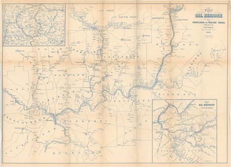
The Oil Regions of Pennsylvania and Western Virginia This very early map of the oil regions in Pennsylvania and West Virginia includes a large inset (8.8 x 8.8"") entitled ""Map of the Oil District of Western Virginia"" and an untitled inset (8.5 x 6"") showing Crawford, Warren, Venango, Mercer and Clarion Counties. The map is very detailed and notes locations of oil wells with the main map also giving extensive property ownership information. The map extends from Utica east to Oil Spring in Kingsley County in the east, and from Oil Creek south to Franklin and beyond to Rockland County. Locates Oil City, and numerous individual wells. The town of Cornplanter, named after a Seneca Indian chief, was renamed Oil City and became the major center, along with Titusville, for the area we know today as the Oil Regions. Printed in blue ink. Issued folding with a few short splits at fold intersections, some minor foxing, and light toning along the folds. 22.3 W x 30.8 H Sweet, S.H. 1865
![Carolina [on sheet with] A Map of ye Island of Bermudos, Divided Into Its Tribes, with the Castles, Forts &c. This is th](http://lot-images.atgmedia.com/SR/36385/2906594/157-201458125847_468x382.jpg)
Carolina [on sheet with] A Map of ye Island of Bermudos, Divided Into Its Tribes, with the Castles, Forts &c. This is the first edition of the Moll-Oldmixon map, which was derived from the important Gascoyne map of 1682. The primary map covers the coast from Cape Henry to B. St. Matheo, and shows small icons representing the numerous plantations in the vicinity of Charlestown. On the sheet at right is a map of Bermuda engraved within its own neatline, with castles and forts marked throughout the island. Moll, a Dutchman living in England since 1680, was ""the most prolific designer and publisher of maps of Carolina"" and was ""as open and effective a protagonist for British territorial claims in North America as was Delisle for the French.""See also lot 763 for Cumming`s excellent reference book, ""The Southeast in Early Maps,"" which discusses this map. A crisp impression issued folding on watermarked paper with minor soiling and a 1"" fold separation at bottom right that has been closed on verso with archival tape. 6.9 W x 10.3 H Moll, Herman 1708

Carte de la Partie Sud des Etats Unis de l`Amerique Septentrionale Attractive and concise copper-engraved map that covers the states of Virginia, North and South Carolina, and Georgia in the new United States. All settlement is confined east of the Appalachians with les Cherokees the only note in the otherwise blank region west of the mountains. There are four distance scales located on the left side of the map. On watermarked paper with light offsetting and a printer`s crease at bottom left. 8.4 W x 12.4 H Bonne, Rigobert 1780

A Map of the Seat of War in the Southern Part of Virginia, North Carolina, and Northern Part of South Carolina This map depicts the southern theater of war during the American Revolutionary War. The map shows the region from Richmond, Virginia to Orangeburg, South Carolina, and extends west to the Allegheny Mountains and the Savannah River. Numerous key locations are noted, including: the battle site at King`s Mountain; the battle site at Guildford Court House; and Wilmington, North Carolina, where General Lord Cornwallis retreated for resupply before heading north into Virginia. Yorktown, Virginia is also shown, although this map was published several months before the Battle of Yorktown, the last major battle of the war. A dotted line near 36.5 degrees latitude depicts the northern boundary of the Granville District, an area previously under the control of the eight Lords Proprietor, and which was confiscated by the State of North Carolina in 1779. There is great detail of towns, forts, Indian tribes, rivers, and swamps. Counties are named but not delineated. Published by R. Baldwin. A rare and desirable map. Issued folding on watermarked paper, now pressed with minor soiling and professional repairs to a few tiny holes at fold intersections. There is a binding trim at right that has been replaced with old paper, and an associated binding tear that enters 2"" into map that has also been professionally repaired. 10.9 W x 13.6 H Kitchin, Thomas 1781

A Map of the States of Virginia, North Carolina, South Carolina and Georgia; Comprehending the Spanish Provinces of East and West Florida... This fine map is a fascinating historical document of the United States following the Revolutionary War. It includes an early reference to the New State of Franklin in western North Carolina. The map includes a great amount of information including boundaries claimed by the various Indian Nations and trading paths on the western frontier. It shows early settlements, including a Moravian Settlement in North Carolina, and the Cumberland Settlements in present-day Tennessee. At the top of the map, in the nascent Northwest Territory, the 7 Ranges denote the first application of the Public Land Survey System. Several bounty land grants are shown including the Ohio Company, Wabash Company, New Jersey Company, Illinois Company, and the Donation Lands of the Commonwealth of Virginia. A triangular shaped plot of land in the region of present-day West Virginia is labeled Indiana. This is a second edition with the imprint of John Stockdale Jan. 25th, 1792 at bottom instead of the imprint of Amos Doolittle dated 1788.In 1785, settlers in present-day western North Carolina and eastern Tennessee organized a state government to be named in honor of Benjamin Franklin, Franklin or Frankland. Congress turned down their appeal but the state maintained a legislature and governor until 1788. This ephemeral state appeared on a small number of maps into the early part of the 19th century. The Revolutionary government of the United States used bounty land grants in their struggle for independence from Great Britain. The free lands exchanged for military service provided an effective technique for enrolling support for the war and encouraging re-enlistments. Generally the bounty lands were located on the western frontier, which provided another benefit to the government. Populating the frontier with citizens skilled in defense offered the best prospect in enticing other settlers to join them, thus eventually increasing the tax rolls. The region shown on this map as Indiana was originally granted to a Philadelphia trading company by the Iroquois Confederacy in 1768. Then in 1776 it was sold to the Indiana Land Company, but was also claimed by the State of Virginia as a part of her original charter. The resulting battle between the private land company and Virginia resulted in the Eleventh Amendment to the U.S. Constitution and is one of the most interesting chapters in the history of the young United States. A crisp impression issued folding, now flattened, with several fold separations and edge tears that have been archivally repaired with a minute amount of image missing. 12.5 W x 14.4 H Purcell, Joseph 1792

Carte de la Floride et de la Georgie Handsome early map covering from South Carolina to Florida and the Bahamas and much of the lower Mississippi valley. The map depicts Florida and southern Louisiana during the period it was controlled by the Spanish. There are no engraved political divisions indicating the mapmaker`s bias toward the territorial claims of either Spain or the United States. In Georgia, settlement is confined to east of the mountains, while a large number of Indian villages and a few French forts are shown on the western frontier. The map provides an excellent view of the Gulf Coast with a dramatically oversized Tampa Bay (Baie de St. Esprit), reflecting the limits of contemporary knowledge of the region. Numerous Indian villages are located and roads are shown connecting early settlements. In central Florida the southern-most settlements are Dest, Suliga and Allavatra. The Bahamas are also well delineated. Published by Chanlaire & Mentelle and engraved by P.J. Valet. A nice impression on watermarked paper with light toning along sheet edges. 12.9 W x 16.8 H Tardieu, Pierre Francois 1797
![[Lot of 2] Amer. Sep. Partie des Etats Unis. No. 57 [and] Amer. Sep. Partie des Etats-Unis. No. 57 (bis) A. Amer. Sep. Parti](http://lot-images.atgmedia.com/SR/36385/2906594/163-201458125858_468x382.jpg)
[Lot of 2] Amer. Sep. Partie des Etats Unis. No. 57 [and] Amer. Sep. Partie des Etats-Unis. No. 57 (bis) A. Amer. Sep. Partie des Etats Unis. No. 57 (19.4 x 18.2""). Covers the region from northern Florida to southern North Carolina. Shows the topography of the southern Appalachians and river system and lists numerous towns and cities. Condition: An attractive example in original color with just a few small, faint spots of foxing. (A) B. Amer. Sep. Partie des Etats-Unis. No. 57 (bis) (19.4 x 19.8""). This sheet, comprised mostly of text, includes the Outer Banks of North Carolina along with an inset of Bermuda. Condition: Original color with light color offsetting and a few spots of foxing. (B+) The Atlas Universel contained 400 maps in six volumes. It was the first atlas made up of lithographed maps, and the first to present all the maps on the same scale (1: 1,641,836), with each map covering an area of approximately 20 degrees longitude (from Paris) and 6 degrees of latitude. If all the maps were joined together they would form a globe of 7.75 meters in diameter. The maps were published by subscription between 1825 and 1827, with each part containing ten maps. There was only one edition and the subscription list shows that 810 copies were sold; thus the maps are quite rare. See description above. 18.2 W x 19.4 H Vandermaelen, Philippe Marie Guillaume 1825

La Floride This influential map shows the Spanish and French possessions in the southern part of the United States. The map extends from the southernmost part of Virginia to the coast of what is now Texas. When first introduced by Sanson in 1657, this map was the first to use the name L. Erie in an atlas and to introduce several new rivers in Virginia. The French claims in the Carolinas are reasserted with the region named Floride Francoise, despite the region not having had any French presence for nearly 100 years. The place name Caroline is not related to the future English colony of Carolina. Instead it is a confusion between the French Fort Caroline on the St. Johns River, and Charlefort that was located near Port Royal. This is the first state as defined by Burden.See also lot 763 for Cumming`s excellent reference book, ""The Southeast in Early Maps,"" which discusses this map. A nice impression on watermarked paper, remargined with old paper on all sides. 6.9 W x 9.9 H Sanson, Nicolas 1683

`T Amerikaans Gewest van Florida Door Ferdinand de Soto This interesting copper engraved map is based on Sanson`s map of 1657. It covers the region from Texas to Chesapeake Bay, with many place names noted. The British colonies of Carolina and Virginia are shown east of the Appalachian Mountains, with the rest of the western part of the map named Florida. Lac Erie is shown considerably south of its actual location and the river systems are incorrect. A spurious north-south mountain range stretches through the central plains. Texas is labeled Terlichichimechi and the Florida Peninsula is named Tegesta Prov. A large title cartouche takes up the Gulf of Mexico with a scene of Ferdinand de Soto discussing his expedition with a group of Native Americans.See also lot 763 for Cumming`s excellent reference book, ""The Southeast in Early Maps,"" which discusses this map. A fine impression with very faint offsetting. Issued folding. 6 W x 9 H Aa, Pieter van der 1707

Carte de la Floride, de la Louisiane, et Pays Voisins This is a finely engraved French and Indian War period map of French Louisiana. It extends from the Great Lakes in the north and Nouveau Mexique in the west, to the Gulf of Mexico and shows about half of Florida. The Mississippi River flows dramatically down the center of the map with tributaries including the Ohio River, (l`Oyo ou la Belle), Missouri River, and the Riviere de Moingona in the area of modern-day Des Moines. The map is filled with place names including many Indian tribes, missions, forts, and early settlements. Adorned with a rococo-style title cartouche including a distance scale. A nice impression on watermarked paper with just two small brown stains in the left portion of the image. 8.6 W x 11.9 H Bellin, Jacques Nicolas 1757

Luigiana Inglese, colla Parte Occidentale della Florida, della Giorgia, e Carolina Meridonale This map provides a great regional description of the Gulf Coast from New Orleans to Florida, and of the valley of the Mississippi River north to above the Arkansas River where Hernando de Soto was supposedly buried. The map also details Mobile Bay and the course of the Albama River and tributaries, as well as the region of Capo S. Biagio and the course of the Apalachicola River. In the north, the prominent trading route, Strada de Coll Welk, nearly reaches the Mississippi River and is marked with distances between important points. Another road is shown in Florida and several Indian trails are depicted. Numerous Indian tribes are located and there are notations concerning the quality of the land. The map is sheet X from Zatta`s Le Colonie Unite dell` America Settentrle, which is often referred to as the Italian edition of John Mitchell`s map, on which it is based. Zatta`s maps retain Mitchell`s scale, but being smaller are more legible. Zatta also included updated legends (in Italian) with notations concerning the Revolutionary War, such as Burgoyne`s defeat at Saratoga. A nice impression on watermarked paper with some faint toning along the centerfold. 12.5 W x 16.5 H Zatta, Antonio 1778

Carte de la Louisiane, et de la Floride This handsome map of the American Southeast and the Mississippi River Valley extends from Charleston, South Carolina west to include New Orleans and north into southern Illinois. In this French-produced map Louisiana extends to the Appalachian Mountains bordering the southern colonies. The Mississippi and Ohio Rivers are well delineated. Florida is shown with its panhandle extending west to include Mobile and Biloxi. Locates Charles Town, Savannah, St. Augustine, Mobile, Pensacola and several far western settlements and forts in the frontier. A small inset provides details of the Missouri River. Six distance scales fill the Gulf of Mexico. Engraved by Andre. Minor soiling with a bit of offsetting along the centerfold and a closed edge tear confined to the left blank margin. 12.7 W x 8.4 H Bonne, Rigobert 1780

Map of the Southern States, Including Rail Roads, County Towns, State Capitals, County Roads, the Southern Coast from Delaware to Texas, Showing the Harbors, Inlets, Forts and Position of Blockading Ships This terrific Civil War map shows good detail of the towns, villages, railroads, and the ship blockade of the south. The title continues along the bottom: ""Prepared for Harper`s History of the Rebellion. December, 1863."" Surrounded by a very decorative border, it features portraits at each corner of Lincoln, Seward, Gen. Scott, and Gen. McClellan. An inset of ""Florida. Southern Part."" lies at lower right. On the verso are three black and white wood engraved birds-eye views, two single page and a large double page. The double page view details the region around the Chesapeake Bay and is titled ""Pictorial Map of Portions of Delaware, Maryland, Virginia, and North Carolina "" The other two are ""Balloon View of Fortress Monroe and Hampton Roads"" and ""Balloon View of the Seat of War."" An uncommon issue. Folding, as issued. This example has terrific original coloring, full margins, and a dark impression with a small chip out of Georgia. There is light toning along one fold, numerous fold splits, and some marginal tears or chipping, all of which are closed on verso with archival tape. Shows much better than the condition suggests. 20.1 W x 30.1 H Harper`s Weekly, 1863

Cours du Mississipi et la Louisiane This interesting, small map is focused on the Mississippi River Valley and extends to Michigan and the northern Plains. The colonies of Florida and Carolina are shown on the right. The map includes a portion of the Gulf Coast, with New Orleans located and a town of Teijas named in preset-day Texas. A note nearby records the presence of the French explorer La Salle in 1685, just a couple of years before his murder at the hands of a mutinous follower in 1687. Watermarked paper with minor toning and a few faint damp stains primarily in the blank margins. 8.4 W x 6.4 H Robert de Vaugondy, Didier 1749

Carte de la Louisiane et Pays Voisins pour Servir a l`Histoire Generale des Voyages Superb small map based on Delisle`s map of the French colony of Louisiana. This finely engraved and detailed map of French Louisiana extends from the Great Lakes to the Gulf of Mexico and from Nouveau Mexique to Florida (not showing the tip of Florida). Many Indian place names, forts and early European settlements are shown. Nouveau Mexique in the far west includes Santa Fe and names the S. Jerome de Taos. The decorative title cartouche includes the distance scale. Issued folding on watermarked paper with faint offsetting and a few light stains. 8.7 W x 12 H Bellin, Jacques Nicolas 1757

N.W. Territory This is the earliest printed map to show the North West Territory. It covers the region of the upper Mississippi Valley and the Great Lakes, and shows the rivers and streams together with settlements, mines, and forts. Lit. Fort appears at the mouth of the Chicago River and Old Ft. Orleans appears on the Missouri River. The southern end of Lake Michigan is placed almost a full degree further north than the southern shore of Lake Erie, an error that resulted in a series of boundary disputes between Michigan and its neighbors in the 19th century. The fictitious Charlevoix-Bellin islands appear in Lake Superior. This is the second state which is geographically identical to the first, with only the addition of two small lines to strengthen the tiny circles locating the towns of Detroit, Sandusky, etc. Accompanied by three loose sheets of text containing an entry on the North West Territory. Issued folding, now flat, with light soiling. 7.3 W x 6.2 H Scott, Joseph 1800

Geographical, Statistical, and Historical Map of Arkansas Territory For this commercial atlas version of the seminal Stephen Long report map, Carey & Lea chose a single sheet format at a reduced scale with the political boundaries highlighted in color. It carries the cartouche title Map of Arkansas and Other Territories of the United States Respectfully inscribed to the Hon. J.C. Calhoun Secretary of War by S.H. Long Major T. Engineers and appears on a full folio sheet with text measuring 20.5 x 16.6"". This is one of the most important maps of the American West, which Wheat calls the ""most interesting map in this Atlas."" It covers the Missouri River Basin north to the Mandan villages and west to the Rocky Mountains. Long`s map corrected a number of geographical inaccuracies, foremost the erroneous course of the Red River. As on Long`s manuscript map the ""Highest Peak,"" James Peak, and Spanish Peaks appear and the route of his expeditions are clearly delineated. Extraneous details, including Major Long`s astronomical notations, camp site locations, and elevation profile were eliminated, and information about Arkansas and surrounding territories was added in columns framing the map at the sides. South of the Republican Fork appears the significant legend that reads ""The Great Desert is frequented by roving bands of Indians who have no fixed place of residence but roam from place to place in quest of game""; this is a change from Long`s report map, where he famously referred to the ""Great American Desert."" A note refers to ""Pawnee villages deserted in 1810,"" whereas the Long map uses the date of 1820. Salt works, Potatoe Hills, a large number of Indian villages and lands, A Broad and extensive swell of Land called by the French Coteau de Prairie, and Say`s route are located, along. Thomas Say was the expedition`s naturalist and entomologist, and is considered to be the father of American entomology. Engraved by Young & Delleker.Claims are sometimes made that this first edition (1822) Carey & Lea map preceded the publication of the Long report map based on the report`s date of 1823. However, both were actually published in 1822, making the distinction impossible to tell from date alone. Even Wheat erroneously assigns an 1823 date to the Long report map. A mystery that deserves further study. Original hand color with toning concentrated mostly along the centerfold, light offsetting, and a couple of spots in the text columns. There is a centerfold separation at bottom that does not enter the map. 14.5 W x 14.7 H Carey & Lea, 1822

North America Sheet V The North West and Michigan Territories This is an interesting map of most of the Northwest Territory and Michigan Territory. It has the elongated Lake Michigan and bears some resemblance to Burr`s map of 1831. The Ottawa and Miami Indian nations are shown occupying the whole northern part of Michigan and the only settlement in the North West Territory is Green Bay Township along with Fort Howard. There are a few minor abrasions, light toning along sheet edges, and a small professionally repaired hole at top right. 12.3 W x 15.3 H SDUK Society for the Diffusion of Useful Knowledge, 1833

Map Illustrating the Plan of the Defences of the Western & North-Western Frontier, as Proposed by the Hon: J.R. Poinsett, Sec. of War, in His Report of Dec. 30, 1837 This map was issued as part of the continuing debate over the nature of the frontier defenses between the Mississippi River and the Rocky Mountains in the Secretary of War, J.R. Poinsett`s report of 1837. It illustrates the proximity of the hostile Indian threat that existed in the 1830s and shows the location of Army posts that were expected to respond to any hostile action. The military troops at these individual posts were inadequate to counter significant Indian opposition making it necessary for speedy reinforcement. The map includes the states of Missouri, Arkansas and Louisiana and the Indian nations bordering them to the west. Locates many military forts and outposts from Ft. Jessup to Ft. Snelling with notations throughout concerning the regions ceded by several Indian nations with the dates of the treaties. Issued folding and now flattened and backed with tissue to reinforce and repair several short fold separations and a 2"" binding tear at left. 21.3 W x 15.5 H Poinsett, J. R. 1837
![[Untitled - Great Plains: Fort Leavenworth to Santa Fe] This map details the 1835 expedition of Dragoons under the command o](http://lot-images.atgmedia.com/SR/36385/2906594/177-201458125924_468x382.jpg)
[Untitled - Great Plains: Fort Leavenworth to Santa Fe] This map details the 1835 expedition of Dragoons under the command of Colonel Henry P. Dodge. The map, attributed to Lt. Steen, extends from Pike`s Peak, Touse (Taos) and Santa Fe in the west and east to Fort Leavenworth. It locates rivers, mountains, Indian reservations, Indian villages, military posts, and the Santa Fe Trail. The map was originally published in 1836 as part of HR Doc. 181, 24th Cong., 1st Session. A landmark map for illustrating land holdings of the Western Indians. Issued folding with just a little faint offsetting. 9.9 W x 17.9 H U.S. War Department, 1860
-
109182 item(s)/page