We found 109182 price guide item(s) matching your search
There are 109182 lots that match your search criteria. Subscribe now to get instant access to the full price guide service.
Click here to subscribe- List
- Grid
-
109182 item(s)/page


Lot 417
A collection of WW2 Military Booklets including Home Guard Instruction no51 part 1, 2, 3 , 4 and no64, Elementary Map Reading, Infantry Section Leading, Small Arms Training vol1 pamphlet 2 1937 and 1942 and Pamphlet 13, Home Guard Proficiency, Practical Unarmed Combat, certificate of Post War Credit etc
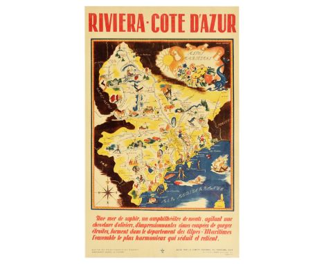
Lot 146
Original vintage travel advertising poster for Riviera Cote d’Azur, featuring a pictorial map marking Alpes, people skiing, playing gold, swimming, sunbathing, buildings and factories on land, and ships and fish in the water, compass in the bottom left, caption below reads - A sapphire sea, an amphitheatre of mountains, waving a hair of olive trees, impressive peaks cut by narrow gorges, form in the department of the Alpes-Maritimes the most harmonious whole which seduces and retains. Published by Ministry of Public Works and Transport. General Commissariat for Tourism. Edited by the Regional Committee for Tourism, Nice. Heliochromy print by Sadag, Bellegarde. Good condition, repaired tears, crease marks, backed on linen. Country of issue: France, designer: Simone Garnier, size (cm): 100x62, year of printing: 1930s.
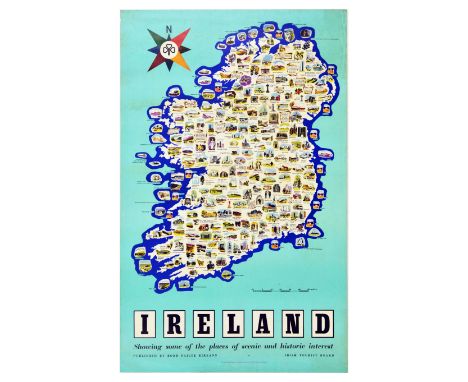
Lot 160
Original vintage travel map poster for Ireland - Showing some of the places of scenic and historic interest. The pictorial map of Ireland is packed full of annotated illustrations of tourist attractions and landmarks. Multicoloured compass appears in top right corner. Published by Bord Failte Eireann. Printed in the Republic of Ireland by Browne and Nolan Limited Dublin. Fair condition, tears, creasing, staining, pinholes, foxing. Country of issue: Ireland, designer: Unknown, size (cm): 101x64, year of printing: 1950s.
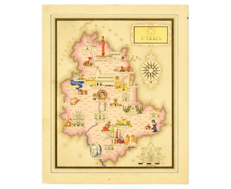
Lot 173
Original vintage travel advertising poster for Umbria featuring an illustrated map with castles, cathedrals, food and wine, statues, and tourist places of interest like lake Trasimeno, Marmore Falls, River Tiber, Perugia, Assisi, and a compass. Good condition, creasing, staining, tears, tape on image. Country of issue: Italy, designer: Vsevoldo Nicouline, size (cm): 29x24, year of printing: 1950s.
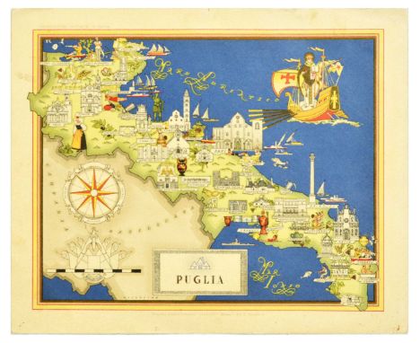
Lot 174
Original vintage travel advertising poster for Puglia featuring an illustrated map with a compass, castles, cathedrals, food and wine, statues, and tourist places of interest like Ionian Sea. Puglia or Apulia has its capital in Bari, the region is known for Castel del Monte and the medieval town of Ostuni. Horizontal. Good condition, creasing, staining, ink drawing on reverse. Country of issue: Italy, designer: Vsevoldo Nicouline, size (cm): 24x29, year of printing: 1950s.
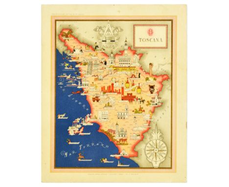
Lot 175
Original vintage travel advertising poster for Toscana / Tuscany featuring an illustrated map with a compass, castles, cathedrals, food and wine, statues, and tourist places of interest like the leaning tower of Pisa, Tirenze, Florence. Tuscany is known for landscapes, wines like Chianti and Montepulciano, popular tourism destinations such as San Gimignano, Lucca, catiglione della Pescaia, Grosseto and Siena. Very good condition, minor creasing, minor staining. Country of issue: Italy, designer: Vsevoldo Nicouline, size (cm): 29x23, year of printing: 1950s.
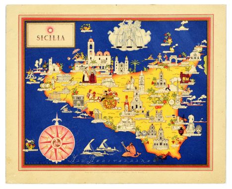
Lot 176
Original vintage travel advertising poster for Sicilia / Sicily featuring an illustrated map with a compass, castles, cathedrals, food and wine, statues, and tourist places of interest like Palermo, Mount Etna, Catania, Syracuse, Ragusa. Horizontal. Very good condition, minor creasing, minor staining. Country of issue: Italy, designer: Vsevoldo Nicouline, size (cm): 24x29, year of printing: 1950s.
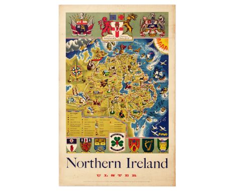
Lot 179
Original vintage travel poster Northern Ireland Ulster featuring a great pictorial map with the arms of the government of Northern Ireland, marking ports, cities, towns, villages, golf courses, tennis courts, castles, abbeys, churches, cathedrals, crosses, megaliths, mounds, rivers, locations hunting, swimming, bathing, and shooting, with ships and sailboats in the North channel and fish and seagulls above the Irish Sea. Good condition, tears, creasing, staining, foxing, pinholes, paper loss in top left corner. Country of issue: UK, designer: Griffin, size (cm): 97x62, year of printing: 1955.
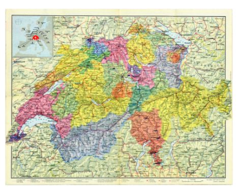
Lot 181
Original vintage travel map – Tourist map of Switzerland – featuring a map of the country marking ferries, railways, funiculars, chair-lifts, postal motor coach services, lines leased to private coach owners, highroads, airports, boats, the reverse of the poster features short articles on Switzerland, Fribourgh, Neuchatel, Jura, the Bernese country, Lake of Geneva, The Valais, the Grisons, Tessin. Horizontal. Good condition, staining, paper skimming, small tears, folds as issued, double sided. Country of issue: Switzerland, designer: Unknown, size (cm): 18x12 (folded) 36x47 (unfolded), year of printing: 1958.
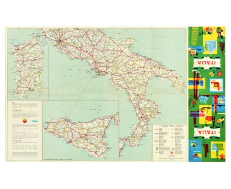
Lot 184
Original vintage travel map for Italy, featuring a map of the country marking autoroads, main highways, other roads, distances in kilometres, mountain passes, centres of great tourist interest, state frontiers, important roads, altitude, Shell touring stations. Good condition, folds, tears, creasing, minor staining, ink markings, double sided. Country of issue: Italy, designer: Unknown, size (cm): 22x12 (folded) 44x71 (unfolded), year of printing: 1959.
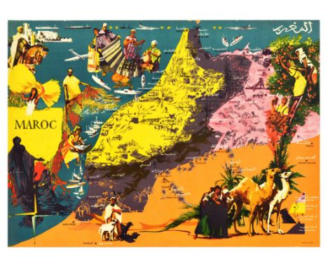
Lot 188
Original vintage travel advertising poster for Maroc / Morocco, featuring a colourful map of Morocco marking major cities, with illustrations of fishermen, craft makers with rugs, ornate metal works, pottery, people picking fruit, goats, camels, and horses, the reverse of the poster features article titled Industries in Morocco on forest produce, cereals, citrus fruit and other fruit, canned fruit and vegetables, wines, handicrafts, phosphate sand mineral ores, tomatoes and vegetables, tinned fish, oil and olives, medicinal herbs, esparto grass, vegetable horsehair, cotton, and live stock. Horizontal. Good condition, creasing, tears, double sided. Country of issue: Morocco, designer: Unknown, size (cm): 43x60, year of printing: 1962.
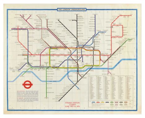
Lot 217
Original vintage travel poster The London Underground featuring a tube map with Victoria, Central, Circle, Piccadilly, District, Metropolitan, Northern, and Bakerloo lines. Horizontal. Good condition, folds, creasing, tears, minor staining. Country of issue: UK, designer: Paul E. Garbutt, size (cm): 101x125, year of printing: 1970s.

Lot 242
Set of three original vintage newspaper insert sport posters for the Tour de France cycling races. 1. 40 Tour De France Map marking the route from Strasbourg to Paris, with cartoon illustrations of cycling racers, and advertising by Terrot of a motorcycle, table of results below the image, the reverse features articles on fashion. The 40 Tour de France bicycle race was won by a French cyclist Louison Bobet, with his countrymate Jean Mallejac ranking second, and Italian racer Giancarlo Astrua in third. Good condition, folds, creasing, staining, tears, paper loss on edge, blue ink handwriting, double sided. Country of issue: France, designer: Unknown, size (cm): 59x43, year of printing: 1953.; 2. 39 Tour De France Map marking the route from Brest to Paris, with cartoon illustrations of cycling racers, animals, local characters and landmarks. Graphs and a table of results below the image, the reverse features articles, cartoons and advertisements. The 39 Tour de France bicycle race took place in 1952 and was won by a Italian racer Fausto Coppi. Fair condition, folds, tears, creasing, staining, torn on edges, double sided. Country of issue: France, designer: Unknown, size (cm): 59x45, year of printing: 1952.; 3. 41 Tour De France Map marking the route from Amsterdam to Paris, with cartoon illustrations of cycling racers, animals, local characters and landmarks. Graphs and a table of results below the image, the reverse features articles, cartoons and advertisements. The 41 Tour de France bicycle race took place in 1954 and was won by a the French racer Louison Bobet. Good condition, folds, creasing, staining, tears, torn on edges, blue ink handwriting, double sided. Country of issue: France, designer: Unknown, size (cm): 59x43, year of printing: 1954.

Lot 392
Original vintage warning propaganda poster sign - United Nations UNEF United Nations Emergency Force – Stop! Disengagement Area U.N.E.F. Only – featuring blue emblem of the United Nations – map of the world with a wreath of the olive tree branches, and black lettering in English, Hebrew and Arabic, blue frame around the image. Good condition, creasing, pinholes, tears, staining, backed on board. Country of issue: Israel, designer: Unknown, size (cm): 34x44, year of printing: 1970s.

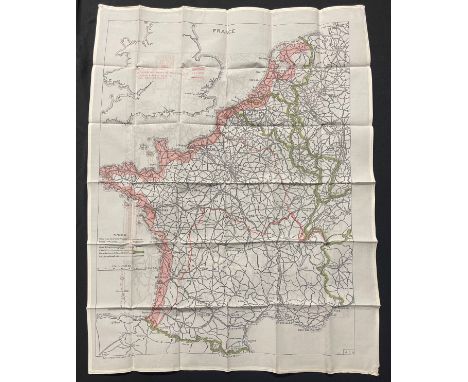
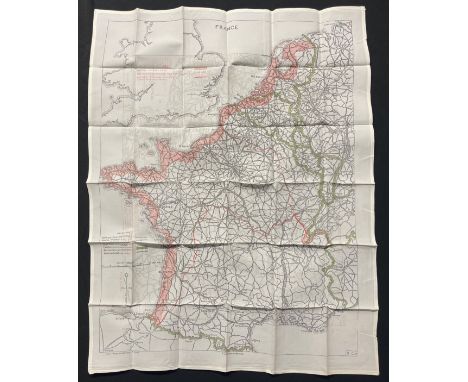
Lot 2652
Altkolorierter Kupferstich von Matthäus Seutter, Augsburg, um 1730 - 1740. Stadtplan mit Befestigungsanlagen; darunter Gesamtansicht mit seitlichen Allegorien. Betitelt "Magdeburgum Ducatus cognominis Metropolis ad Albium (...)" bzw. "Magdeburg die Haupt Statt eines Herzogthumß gleichen Nahmens an der Elb, dem König in Preussen zustaendig(...)". Plattenmaß ca. 50 cm x 58 cm. Rahmen.A hand-coloured copper engraving with a map and a view of Magdeburg by Matthäus Seutter published in Augsburg circa 1730 - 1740.

Lot 2647
"Tabula Russiae (...)". OriginaltitelAltkolorierte Kupferstichkarte von Hessel Gerritsz (um 1581 - 1632), in der Platte dat. 1614. Erschienen bei Willem Blaeu (1571 - 1638) bzw. Joan Bleau (1596 - 1673), Amsterdam, 1614 - um 1665. Die historisch bedeutende Karte zeigt, dass Russland zu Beginn des 17. Jhs. unter der Romanow-Dynastie ab 1613 auf die nördlichen zwei Drittel des heutigen europäischen Russlands beschränkt war, eingeklemmt zwischen dem polnisch-litauischen und dem schwedischen Reich, dem Ural und der osmanisch-kontrollierten Ukraine. L. o. ein Nebenplan bzw. eine Vogelschauansicht von Moskau; auf der rechten Seite eine Ansicht der wichtigen Hafenstadt Archangelsk mit drei darüber stehenden Figuren in russischer Tracht; die Titelkartusche mit Trophäen, Zarenkrone und russischem Doppeladler. Plattenmaß ca. 42,7 cm x 54,7 cm; Blatt ca. 48 cm x 59,5 cm. Rahmen.A rare hand-coloured copper engraving with an early map of Russia and views of Moscow and Archangelsk in 1614 by Hessel Gerritsz, published by Willem Blaeu or Joan Bleau in Amsterdam, 1614 - approx. 1665.


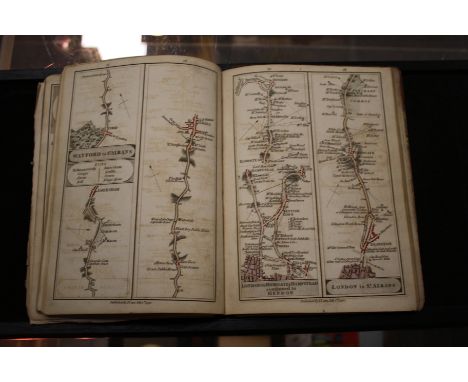
Lot 319
John Cary's Survey of the High Roads from London, First Edition. Printed for J Cary, Engraver and Map Seller July 1st 1790, engraved title, Explanation, Advertisement, hand coloured folding General Map and General Plan, with all 80 hand coloured split maps from London to Richmond, marbled end boards detached


Lot 437
Speed (John), Yorkshire, Performed by John Speede, and are to be sold in Popes heade Alley ... by Thomas Bassett in Fleet Street and Richard Chiswell in St. Pauls Churchyard, hand-coloured engraved map, English text verso, mileage cartouche and decorative border, mounted, glazed both sides and framed, mount aperture 40cm x 52cm.
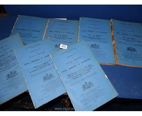
Lot 2034
Royal Commission on Vaccination Appendix's 1897; seven reports with maps and charts, etc, covering the outbreak of Smallpox in Dewsbury, London and Warrington including large scale 12" to mile map (39" x 28") and nine smaller (20" x 13"). Leicester including; large 6" to mile map of city (27" x 32"). Gloucester including; 16 city plans 1" to 200 yards (14 1/2" x 12") showing houses infected progressively. Total 1100 pages with maps, charts, etc.


Lot 1250
A quantity of ordnance survey maps including Batholomews, 'Wales and the Marches quarter inch cloth map etc and an illustrated leather bound book 'The complete Atlas consisting of one hundred and twenty maps of modern, historical, classical and physical geography', published by Williams Collins, sons & company.
-
109182 item(s)/page