We found 109198 price guide item(s) matching your search
There are 109198 lots that match your search criteria. Subscribe now to get instant access to the full price guide service.
Click here to subscribe- List
- Grid
-
109198 item(s)/page


Lot 133
CANADIAN INTEREST - A GROUP OF DOCUMENTS RELATING TO SIR GENERAL CHARLES TROLLOPES SERVICE IN NORTH AMERICA, mainly in Halifax and Quebec, to include a hand drawn plan of the barracks and fortifications at Quebec C. 1860, a collection of calling cards relating to French Officers who visited him in Halifax during the Summer of 1859, various hand written correspondence and documents and printed ephemera including 'addresses to Major General Trollope on his departure from Halifax, Nova Scotia 1861' and a cloth back section map of Prince Edward Island and part of New Brunswick 1854 pub. by James Dawson & SonProvenance: From the archive of General Sir Charles Trollope


Lot 495
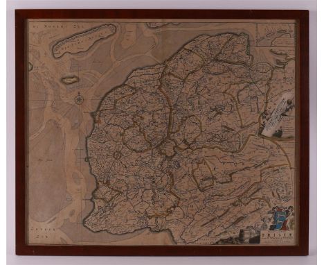
Topography, Friesland."Comitatus Frisiae", ca. 1690. Copper engraving/paper, of the province of Friesland, published by Frederik de Wit in Amsterdam in ca. 1690. The map mentions more than 1500 names of waters and homesteads. Right cartouches with scale sticks and a legend. An inset card “Caerte vande Vriese Eylanden” is engraved at the top right. The original of this map was made by Bernard Schotanus a Sterringa in 1664. Nicolaas Visscher copied the map in 1670. The map appears in composite atlases by Nicolaas Visscher, Frederik de Wit and Pieter Schenk. Framed, with passe partout.

Lot 723
Topography. Map of the famous and antique city of Groeningen: Reproduction of the 4-part map of Haubois / illustrated and cut in copper by Jan Lubberts Langeweerd, 20th century emphasis; appeared as an appendix to the article about this map by C.H. Peters in the Groningsche Volksalmanak 1906, p. 115.


Lot 104
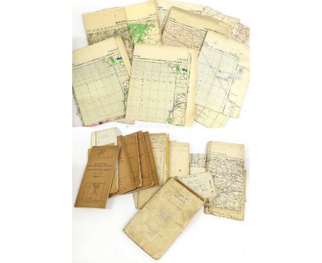
Six UK Ordnance Survey 1940 War Revision Maps, comprising sheet 41 - Anglesey; sheet 42 - Llandudno & Denbigh; sheet 52 - Stoke on Trent; sheet 53 - Derby; sheet 62 - Burton & Walsall; sheet 68 - Barmouth & Aberystwyth, all 1" to 1 mile; Nine RAF Edition Maps of Scotland, each ¼" to 1 mile scale, comprising Sheets 2,4,5,6,7,8,9, &10(x2 - one lacking cover), all circa 1935-1938; a UK Aeronautical War Office Map of South West England, sheet 7 - af; twelve War Office and Three Other Aeronautical Maps of Europe, each 1/500,000 scale, including Bordeaux, Brest, France - East of Paris, Norway Stieskp (German edition), Casablanca, Marrakech, Oran, Sfax, Tangier and Tunis (31 - list available)

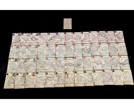
Lot 498
A very rare Robert Morden Miniature Map Playing Cards probably circa 1676, complete set of fifty-two cards with Explanation card, each featuring a county of Great Britain, the King features a roundel of Charles II, the Queens, Catherine of Braganza and various males as Jacks, hand-coloured, square corners, gilt edges, held in purpose made conservator’s box —3 3/4in. (9.5cm.) height of cards (eight of clubs slightly larger and not coloured, from a later edition) - this set is believed to be a first or early edition as adjacent counties not named, some of the first maps to show main road

Lot 105
A box of various items including a set of three Ridgeways Variety brown transfer decorated elongated octagonal meat plates and matching sauce tureen, a Davenport of Longport Staffordshire puce banded and floral spray banded part dessert service, comprising comport, two tazzas and six plates, an oval plated dish with beaded edge, a Meissen (second) transfer decorated relief work plate, a French faience floral spray decorated ink stand, a simulated tortoiseshell papier-mâché box with segmented interior, the lid decorated with lovers in a landscape and two further papier-mâché boxes and a hand-coloured engraved map of Cambridgeshire AFTER RICHARD BLOOME

Lot 164
WWII Ley Kenyon signed The Great Escape Stalag Luft III collection includes introduction signed by Lee Kenyon dated 1977, 9 14x10 inch approx pencil drawing prints taken from the original drawings made by Lee Kenyon in 1943, map picturing the tunnel layout. =Good condition. All autographs come with a Certificate of Authenticity. We combine postage on multiple winning lots and can ship worldwide. UK postage from £5.99, EU from £7.99, Rest of World from £9.99
Lot 104
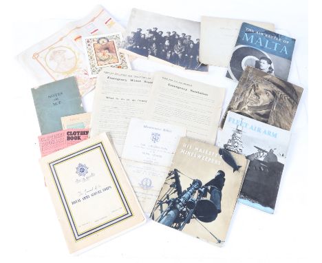
First/Second World War ephemera including, a group photograph of Chaplains of the Army Chaplains Department with Orthodox priests, Middle East or Balkans WW1, printed WW1 patriotic cloth to the Royal Navy ' From the Victory to the Queen Elizabeth, For The Ships May Change But The Spirit Remains', Daily Telegraph Map of the Western Front (WW2), Motor Fuel Ration Book 1948, Clothing Books 1945-1948, Westminster Abbey service of celebration on the 3rd anniversary of the Formation of the Home Guard, May 16th 1943, Emergency Water Supply/Emergency Sanitation leaflets issued by the Emergency Committee of Stowmarket Urban District Council, Notes on MT (1939), HMSO publications on His Majesty's Minesweepers, Fleet air Arm, Front Line 1940-1941 (Civil Defence), Air Battle For Malta, (qty)

Lot 238
REVELL; seven scale model kits, mostly planes, comprising 'Junkers G-24', 'Cousteau's PBY Flying Boat', 'Battle of Britain Memorial Flight', 'USS Franklin D. Roosevelt CVB 42 Aircraft Carrier with Historic Map', 'Heinkel HE 219 "UHU"', 'Junkers JU 188' and 'Fiat BR20 "Cicogna"', all boxed (7).Condition Report: - These all belonged to the vendor's father. The vendor states that to the best of their knowledge, none of these have had items removed, and they should be complete. However, this is no guarantee that all components are present. Some boxes will also have white labels with writing on, with extra description.

Lot 719
A large maroon leatherette A1 art folio containing various coloured lithographs relating to Liverpool Polytechnic Graphic Design Department, including seven relating to the same image, with various layers of coloured print, 66 x 51cm, three unsigned colour lithographs of Prisoners of War, in two separate colourways, 56 x 80cm, a signed limited edition coloured lithograph of the River Mersey, with map view of the city either side, signed in pencil lower right and titled 'The River' lower left, numbered 5/9, 57 x 79cm, a signed limited edition colour lithograph off the Liver Building titled 'Liver Bird' and numbered 8/15 lower left, signed Chris Hopkins and dated '82 lower right, a signed artist's proof coloured lithograph depicting the Union flag with a sailing boat laid over, indistinctly signed lower right, a view of Liverpool from the Rover Mersey, a print depicting six figures in a boat, three coloured prints by M. Dyens, with a textured background, two of which are covered with large letters 'MD', two signed lower left and dated '86, Mark Bolton artist's proof photograph of an elderly lady and a further unsigned example, a coloured lithograph of a church ruin, 51.5 x 37cm, a scale floor plan of the Regional College of Art, Ground Floor, a poster for the Liverpool Polytechnic Graphic Design Show 26th-30th June '87, a further exhibition poster for Liverpool Polytechnic 1981 and a coloured lithograph depicting Sefton Park Palm House, titled to the lower section of the image.


Lot 384
Textiles - an embroidered square linen panel, worked in colourful threads, with central map of Derbyshire, surrounded with Derbyshire scenes and crests, including Chesterfield, Ilkeston, Buxton, Dovedale, Well Dressing, Monsal Dale, etc, 119cm x 119cm; another similar, Hardwick Hall, Haddon Hall, Chatsworth House, etc; others similar (4)

Lot 818
Cartography Interest - John Speed - An uncoloured illustrated map of North Wales with vignettes to side to depict Beaumaris, Carnarvon, Harleig and and so on. To read 'Performed by John Speed, and are to be sold by John Sudbury and George Humble in Popes head Alley - Cum Privilegio 1610. Frames and glazed. Measures 41cm x 55cm.

Lot 877
Cartography Interest - A 17th century road map together with 19th century Indian map. To include an Owen and Bowen road map of South West England to include Tiverton, Minhead (Minehead) Dartmouth. With annotation of the local conveniences eg. ' Newton Bushel - Has a good Mt on Wednesday for corn, cattle & co'. Double sided. Measures 26cm x 33cm. Together with a map to depict 'Northern India: Including the Presidency of Calcutta', illustrations by A. H. Wray & Engraved by J. H. Kernot. Measures 46cm x 38cm.


Lot 77
1955 British & I Lions Post-Tour Presentation Book: Following their very popular & famous trek to S Africa, the Lions were presented with a multi-paged, coloured photographic, travelogue-style hardbacked spiral bound book by the SA Tourist Corporation, with a fine b/w team photo in blazers & flannels, a personalised farewell message (this one to Asst Manager Danny Davies of Cardiff & the WRU), and a striking map with the many cross-country journeys of the Lions detailed. Rare, attractive Lions memorabilia. Excellent.


Lot 307
A quantity of ephemera, to include a GWR Through the Window sightseeing map of the Paddington to Penzance line, Guy Motors Motors Limited 25 years progress in commercial vehicle design, a Rockefeller centre photographic narrative, copy of the Minneapolis records by Alan Hess, brochure for Henry Maudslay Son and Field, Short History of the Maudslay Motor Company, Port of New York Authority brochure, and a Cunard brochure and a book on knots and splices by Captain Jutsum of Cardiff.


Lot 226
10 high ball frosted glasses, 2 glass beer mugs with wooden handles, 1 map, 1 pack of vintage souvenir double sided postcards, 1965 Official Guide New York World's Fair edited by Time-Life Books, and 2 Mary Pillsbury children's books about the New York World's Fair. High ball: 2.75"W x 6.5"H. Mug: 5"L x 3"W x 5"H. Books, map, and packet of postcard combined: 1.25"W x 11.25"H x 8.5"D Issued: 1960sCountry of Origin: United StatesCondition: Age related wear.

Lot 23
(Entertainment/Movie & Music) Freddy Mercury (1946 - 1991)Queen the Complete Works' box set, including a signed album, 1971-1985 tour itinerary, map of countries in which Queen has appeared, a ' Complete Works ' booklet, and album volumes I - XIV. Album XIV is boldly signed in silver ink by Freddie Mercury, Brian May , and John Deacon and in black felt tip by Roger Taylor.
Lot 2719
1965-1981 A.D. Group comprising: 3 x cased Churchill commemorative. Obv: Queen's bust facing right. Rev: bust of Sir Winston Churchill facing right; 2 x First Issue. Obv: Queen on horseback. Rev: crown in centre of emblematical cross, shield of arms in each angle; 5 x Royal Wedding Commemorative. Obv: Queen's bust facing right. Rev: portraits of the Prince of Wales and Lady Diana Spencer with the inscription 'HRH THE PRINCE OF WALES AND LADY DIANA SPENCER 1981'; 2 x Five Pounds Millennium commemorative. Obv: Queen's bust facing right. Rev: a representation of the dial of a clock with hands set at 12 o'clock with a map of the British Isles and the dates '1999' and '2000' and the words 'ANNO DOMINI' and the value 'FIVE POUNDS'. 414 grams total. .Acquired on the UK art market. Property of a Kent lady collector. [12, No Reserve]

Lot 2759
1988-2006 A.D. James Booth - Sylloge of Coins of the British Isles 48: Northern Museums. Ancient British, Anglo-Saxon, Norman and Plantagenet Coins to 1279 - 1997, harback, 283 pp, monochrome photographs; Baldwins - Coins of Mediaeval Europe no.6 (May, 2004); Baldwins - Coins of the Crusades no.6 (July, 2004); C. Wren - The Short-Cross Coinage 1180-1247. Henry II to Henry III. An Illustrated Guide to Identification - 2nd edition 2006, 90 pp, card covers, line drawings, map; C. Wren - The Long-Cross Coinage 1247-1279. Henry III to Edward I. An Illustrated Guide to Identification - 1st edition 1993, 80 pp, card covers, line drawings, map; George C. Boon - Coins of the Anarchy 1135-54 - National Museum of Wales - 1988, card covers, 46pp, colour and monochrome photographs, maps. 1.81 kg total, 21 x 15 - 25.3 x 19.5 cm (8 1/4 x 5 7/8 - 10 x 7 7/8 in.).Property of a Stowmarket, UK, gentleman. [6, No Reserve]


Lot 157
UNITED KINGDOM. Elizabeth II, 1952-2022. Gold 5 pounds, 2020. Royal Mint. Proof. Commemorating the 150th anniversary of the British Red Cross.Fifth crowned head of Elizabeth II facing right; JC below; ELIZABETH II · D · G REG · FID · DEF · 5 POUNDS ·. Design by Jody Clark. / Red cross within small circle overlaid on the map of the United Kingdom; · 1870 · BRITISH RED CROSS · 2020 · above; THE POWER OF KINDNESS below. Design by Henry Gray. Edge milled.In secure plastic holder, graded NGC PF 70 ULTRA CAMEO, certification number 5487853-003. NGC Census in this grade: 82, equal-finest graded.Total NGC Census: 89Diameter: 38.61 mm.Thickness: 2.89 mm.Weight: 39.9403 g. (AGW=1.1777 oz.)Composition: 917.0/1000 Gold.PLEASE NOTE: 6% Buyer Premium + VAT on this lot. Additional 6% fee charged on the Saleroom. Delivery cost will be added to your order.This lot is exempt from VAT. Payment can be made in EUR, CHF, or USD for an exchange fee. Please contact us to find out more.


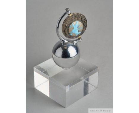
Lot 431
A rare silver & enamel 1934 World Cup commemorative medal awarded to Ottorino Barassi, President and Secretary of FIGC (Italian F.A.) and Director of the FIFA 1934 World Cup Organising Committee, by Giulio Veronesi of Bologna (signed to the reverse), the obverse with an enamel map of the continents, two footballers in raised relief, two fasces and inscribed COPPA DEL MONDO, FOOTBALL, ITALIA, 1934 XII, named in enamel to OTTORINO BARASSI, the reverse enamelled with the flags of the participating nations and with details of all the tournament's matches culminating with the Italy v Czechoslovakia final in Rome, diameter 6.5cm., later swivel-mounted on an orb set on an acrylic base, height 23.5cm. A similar medal awarded to the important Dutch football administrator Karel Lotsy (1893-1959) was offered at Graham Budd Auctions 22nd May 2014 as lot 343. For Biographical information regarding Ottorino Barassi see lot 428. Provenance: By family descent. The following lots 428 to 460 were awarded to Italian Sports Official Ottorino Barassi

Lot 1028
AUSTRALIA, Map of Australia, Compiled from the Nautical Surveys, made by the order of the Abumthy and other, Authentic Documents by James Wilde, in 21 sections mounted on linen and hand coloured in outline, 82 x 58 cm, engraved by Stockley with Van Diemens Land shown in an inset in lower corner, published by James Wilde 1833
-
109198 item(s)/page