We found 109182 price guide item(s) matching your search
There are 109182 lots that match your search criteria. Subscribe now to get instant access to the full price guide service.
Click here to subscribe- List
- Grid
-
109182 item(s)/page


Lot 13
NO RESERVE Europa, carta geografica. Stucchi Stanislao. Carta geografica statistica e stradale d'Europa. Milano: 1846.Grande carta geografica incisa in rame (mm 1545x1570) composta da 54 tavole applicate su tela. Il presente esemplare, con i confini anticamente colorati. Alcune tavole distaccate. Esemplare in buono stato di conservazione.Large engraved map (1545x1570 mm), consisting of 54 plates linen backed, the boundaries in early hand-colour. A few plates loose. A good copy.
Lot 74
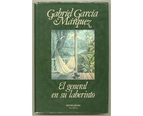
NO RESERVE García Márquez Gabriel. El general en su laberinto. Madrid: Mondadori España, 1989. Dedica autografa dell'autore.(mm 212x135). Pagine 286, [2] di cui una con carta geografica. Legatura in tutta tela rossa con camicia editoriale illustrata a colori da un dipinto di A.G.S., titoli in oro al dorso. Esemplare in buono stato di conservazione, camicia editoriale appena sgualcita ai bordi. Al recto della sguardia anteriore firma di possesso in inchiostro blu e annotazioni a lapis; a p. 7, sotto la dedica a stampa, dedica manoscritta dell'autore in inchiostro nero: 'Para Humberto otra vez'; al verso della sguardia posteriore timbro in inchiostro rosso del Registro Nacional de Bienes Culturales República de Cuba.Prima edizione in lingua originale, con firma dell'autore, uscita in Spagna in contemporanea con le prime edizioni centro e sudamericane. L'opera racconta, in forma romanzata, gli ultimi anni di vita di Simón Bolivar (1783-1830), l'eroico generale guida della lotta di Perù, Bolivia, Venezuela, Colombia, Ecuador e Panama verso l'indipendenza dal dominio spagnolo. Marquez si sofferma però, più che sulla gloria e sulle vittorie di Bolivar, sulle disillusioni e sulle sconfitte, evidenziando gli aspetti più intimi dell'esistenza di un uomo che visse amori e passioni con la stessa forza ideologica della sua impresa militare. Il labirinto del titolo, quello in cui il generale morirà in solitudine, è quello formato dai ricordi, immagini sbiadite di un grande sogno di unità nazionale tradito dagli interessi della politica e del potere. (212x135 mm). 286, [2] pages, of which one is illustrated with a map. Publisher's red cloth, with colour illustrated dust jacket, from a painting by A.G.S. Spine with title lettered in gilt. A good copy, minor wear to the dust jacket. Author's signature in blue ink on the recto of the front flyleaf, and a few pencilled notes. Autograph address in black ink on p. 7, below the printed dedicatory, 'Para Humberto otra vez'; red stamp of the Registro Nacional de Bienes Culturales República de Cuba on the verso of the rear flyleaf. Presentation copy of the first edition in original language, simultaneously issued in Spain, Central and South America. The work narrates the final years of life of General Simón Bolivar (1783-1830), the heroic and legendary liberator of Perù, Bolivia, Venezuela, Colombia, Ecuador, and Panama. García Márquez revisites Bolívar's battles, victories, and former glory, wandering in a labyrinth of memories, unsatisfied desires, and regrets.

Lot 377
ROOK, an oil on board still life painting of a sliver goblet and a sprig of greenery, signed lower left, presented in a frame, approximate size 32cm x 20cm, together with a hand tinted map of Leicester and Rutland, approximate size 11.5cm x 22cm and a hand tinted map of Derbyshire, approximate size 26cm x 20cm (3)

Lot 1
ALDOUS HUXLEY. A Biography. vol 1 and 2. Published Chatto Collins. A Private view of L.S Lowry. Published Collins, The Journal of Beatrix Potter 1881-1897. Published Warne, Description of the Dominions of Great Britain Bickham's Birds Eye Map 1748. Published Bickham 1967. TOGETHER WITH OTHER VARIOUS NON FICTION TITLES (2 BOXES)


Lot 31
A hand tinted map of Warwickshire by Emmanuel Bowen circa 1720, verso road map for Chichester, height 18.5cm, width 12cm, framed and glazed, mounted tinted map of Great Britain by Alain Manesson Mawet circa 1683, 16x11cm and two black and white prints of Eton College circa 1828 and amusing image of Jerry in training for a 'Swell' dated 1820 (4)


Lot 822
A coloured map of the county of Chester by Richard Blome, 31 x 37cm, an 18th century road map - London to Shrewsbury, a pair of ink technical diagrams of steam locomotives number 12 class and number 1 class Hawthorns, 15 x 31cm, together with a 19th century sheet of a watercolour study with insects with signed initials EM, dated 1833, 14 x 19cm all framed


Lot 449
John Wolfe & Robert Beckitcopper engravingMap of Arabia and India from the English edition of Linschoten's Itinerario, 1598, printed by John Wolfe and engraved by Robert Beckit. The map itself was originally drawn by Petrus Plancius, one of the leading advocates of Dutch trade with Southeast Asia.14.75 x 20.5in, unframed.

Lot 12
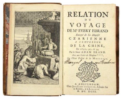
BRAND, Adam. Relation du voyage de M. Evert Isbrand, envoyé de Sa Majesté Czarienne a l’empereur de la Chine, en 1692, 93, & 94. Par le sieur Adam Brand. Avec une lettre de monsieur ***, sur l’etat présent de la Moscovie. Amsterdam, Chez Jean-Louis de Lorme, 1699 "Brand was the secretary to Evert Ysbrandszoon Ides' embassy from the Russian Czar to Peking of 1693-95. His [book] is valuable not only for its description of the route and the Siberian tribes he encountered along the way, but especially for his vivid account of the embassy's experiences in China, his description of the Great Wall and Chinese frontier settlements, and his report of the embassy's reception in Peking. Brand includes a brief general description of China, which appears to have been taken from standard published works. His eyewitness reports of the temples he visited, the dust on Peking streets, the negotiations with Chinese officials, the official banquets he attended, and so forth, are his most important contributions to Europe's knowledge of Asia." (Lach). Originally published in German the previous year, shortly followed by an English translation. First French edition. 12mo, [4], 249, [1] pp, engraved frontispiece, double-page engraving of the Pagoda at Siam, large folding map, contemporary calf, morocco label, spine richly gilt, carmine edges; old ownership inscription to title, corners just bumped, small stains to covers else a fine, fresh copy. Cordier Sinica 2469.

Lot 60
ROBERTSON, David. A tour through the Isle of Man: to which is subjoined a review of the Manks history. London, For the Author, 1794 Second edition. 8vo., [6],233,[1]pp.,engraved map. 8 sepia aquatints, contemporary tree calf gilt, spine in seven compartments, red morocco lettering piece to second, others with fancy gilt blocking, neat repairs to joints and extremities, a very handsome copy. Provenance: Earl of Eldon (signature and armorial bookplate).


Lot 2209
Wotton (H), Reliquiae Wottonianae, London 1651, printed by T Maxey for R Marriot et al and other small bindings, 17th to 19th century, including Valerii, Martialis Epigrammata, Amsterdam 1645, Joannem Janssonium, Almanac de Gotha, 1782, Debrett's, Tristram Shandy, Swift's Works, Hudibras, Candide, The Royal Kalendar 1800, etc., together with Mackenzie Wallace, Russia, 1877, Cassell, Petter & Galpin, 2 vols, folding map, tan half calf with marbled boards (37)


Lot 2506
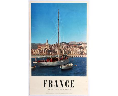
Group of 4 original vintage travel posters advertising destinations in France. 1. Original vintage travel poster promoting France tourist destinations Riviera, Cote d'Azur and Menton. Photograph shows a boat in a dock with old french buildings in the background . Good condition, small tears in margin, some creeasing in margin, staining in margin.Country: France Year:1958 Designer: Ph Trubert Size(cm)99x62; 2.Original vintage travel poster promoting France, Les Échelles De Crancot, Jura. Jean Roubiers black and white photograph depicts the French Countryside, 'France' appears in big bold text below. Very good condition. minor creases in margins and small tear. Country: France Year: 1950s, Designer:Jean Roubier : Size (cm): 100x62; 3. Original vintage travel advertising poster for France, Place Vendome. Place Vendôme is a square in the 1st arrondissement of Paris, France, located to the north of the Tuileries Gardens and east of the Église de la Madeleine. It is the starting point of the rue de la Paix. Black and white photograph by Rene Jaques. Excellent condition.Country: France Year: Designer: Rene-Jaques Size (cm) 100x62; 4. Original vintage travel poster printed for and by French Railways. Featuring a map of france with rail routes as well as black and white photos of trains. Excellent condition, some creasing. Country: France Year: 1947 Designer: Size(cm)99x62
Lot 2509
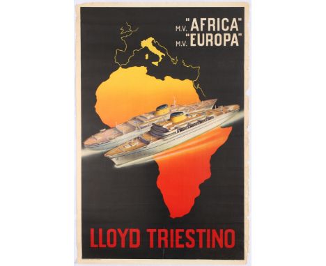
Original vintage travel advertising poster for Lloyd Triestino trips to Africa and Europe. Italia Marittima S.p.A., from 1919 until 2006 called Lloyd Triestino, founded as Österreichischer Lloyd, is a shipping company with its head office in Trieste, Italy, and run by Evergreen Marine Corporation. Illustration shows two ships over a map of Africa and Europe. Fair condition, large tear, several paper losses in margins, several creases. Country: Italy, Year: 1950s, Designer: Size(cm) 100x65
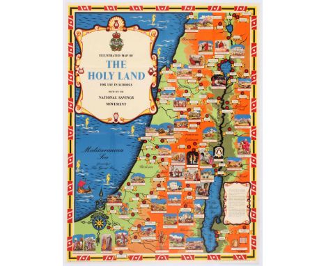
Lot 2514
Original vintage poster showing an illustrated map of Holy Land, issued by the National Savings Movement for use in schools. The illustrations are based on Old and New Testament. The National Savings Movement was a British mass savings movement that operated between 1916 and 1978 and was used to finance the deficit of government spending over tax revenues. Excellent condition, light fold marks. Country:UK, Year:1950, Designer:Mahoney, Size (cm):101x75.5
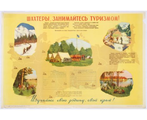
Lot 3507
Original vintage Soviet poster with a slogan: Miners, practice tourism! The poster features Illustrations of outdoor activities such as hiking, skiing, cycling and camping, alongside a table outlining awards you can achieve by completing different activities. A map of USSR can be seen in the backgound. Horizontal. Good condition, folds and tears in margin.Country:Russia, Year: 1958, Designer: G. Korovin, Size (cm):90x59.5

Lot 4301
Original vintage German propaganda poster for the World Congress of International Red Aid / Weltkongress des Internationalen Roten Hilfe IRH held in Moscow in November 1932 in support of the 10 year fight against the White Terror Fascism War and to offer Red Aid to the victims of the anti-fascist liberation struggle / 10 Jahre Kampf gegen Weissen Terror Faschismus Krieg - Mit der roten Hilfe fur die Opfer des Antifaschistischen Freiheitskampfes. Great design featuring a globe with a large red flag of the IRH rising from the map marking the Soviet Union in black against windows and ruins around the earth, the stylised above and below in white, red and black letters. Fair condition, restored loss, repaired tears, creases. Country: Germany, year: 1932, artist: Pewas, size (cm): 70x50.

Lot 4400
Original vintage Soviet propaganda poster featuring the leader of the Soviet Union Josef Stalin looking over a map on his desk and strategizing. Published for an art exhibition commemorating 30 years of the Soviet armed forces. Country: Russia, Year:1948, Designer: Reshetnikov, Size (cm):36x29
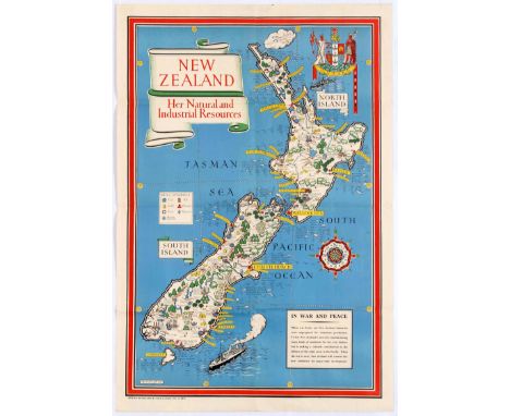
Lot 4406
Original vintage World War Two pictorial illustrated map for New Zealand Her Natural and Industrial Resources featuring a great illustration by the notable graphic designer, cartographer and artist MacDonald Gill (Leslie MacDonald Gill aka Max Gill; 1884-1947) of a map of New Zealand depicting the country's various industrial and natural resources, including farms, mines and forests, gold, hydroelectric works, coal, timber, iron, tobacco, grain, cheese, butter, fruit, fish and sheep with the stylised title text on a scroll design, a plane and Onward coat of arms above, a compass on the side and a ship and information box below - When war broke out New Zealand industries were unprepared for munitions production. To-day New Zealand is not only manufacturing many kinds of munitions for her own defence but is making a valuable contribution to the defence of other areas in the Pacific. When the war is over, New Zealand will convert her new industries for peace time development. Very good condition, folds, minor tear on fold. Country:UK, Year:1943, Designer: Macdonald Gill, Size:79x53
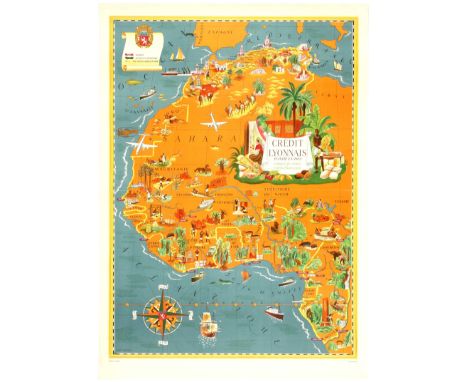
Lot 1613
Original vintage pictorial map of North Africa: French Union, featuring color coded list of agencies and a coat of Arms on upper right corner - Credit Lyonnais Fonde en 1863, Afrique du Nord, Union Francaise. Shows major buildings and landmarks, parks, roads, cities and towns. Good condition, fold marks and creases. Country: France, Year: 1960, Designer: Lucien Boucher, Size (cm): 104x76
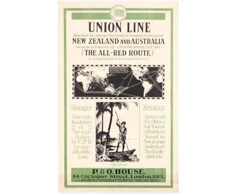
Lot 2100
Original vintage travel advertising poster for Union Line Steam Ship company of New Zealand, advertising routes fom Vancouver, Honolulu and Fiji and the all red route via San Francisco, Tahiti and Raratonga. Illustrations of a route map and a man on a boat appear. Union Line was once the biggest shipping line in the southern hemisphere and New Zealand's largest private-sector employer. It was incorporated by James Mills in Dunedin in 1875 with the backing of a Scottish shipbuilder, Peter Denny. Bought by shipping giant P & O around the time of the First World War it was sold in 1972 to an Australasian consortium and closed at the end of the twentieth century. Good condition, pin holes, small tears, staining in margin. Country: New Zealand, Year: 1910s, Size (cm): 102x63
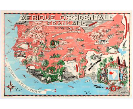
Lot 2302
Original vintage poster showing an illustrated map of Afrique Occidentale Francaise (French West Africa.) Illustrations show people, animals, land marks and attractions that can be found in each area. Good Condition, light fold marks, tears in margin, small paper losses in margin, minor creasing, some ink marks from printing error. Country:France Year:1930s Designer:Leon Craste Size (cm):120x80cm
-
109182 item(s)/page