We found 109182 price guide item(s) matching your search

Refine your search

Year

Filter by Price Range
  • List
  • Grid
  • 109182 item(s)
    /page

Lot 395

Robert Morden's Map of Dorsetshire, coloured

Lot 1022

MORDAN, ROBERT, a map of Staffordshire, hand coloured

Lot 748

AFTER BELLIN, Carte Reduite Du Golphe Du Mexique, a hand coloured map of the Carribean, 23cm x 32cm

Lot 875

A GEOLOGICAL SURVEY MAP OF WARWICKSHIRE AND SURROUNDING COUNTIES

Lot 1646

FOUR VARIOUS PICTURES, etc including a framed ordnance survey map (Isle of Wight) (5)

Lot 1239

EVANS (Commander). "Souvenir of Lecture "The British Antarctic Expedition 1910-1913." map & illus, orig wps, 8vo 1913g; plus 4 misc.

Lot 1252

ENGRAVED MAP. "Brabantia Ducatus..." by M. Seutter. 11 x 9 inches, hand col c 1700 vg

Lot 1300

THOMAS HARDY. "Works in Prose & Verse." Wessex Edition comp in 21 Vols, frontispieces with tissue guards, folding map, orig cl, 8vo 1912-3 some covers stained

Lot 1318

JOHN SPEEDE. fine hand coloured engraved map "Cornwall, Described by the travills of John Norden augmented and published by I. Speed." complete with vign of Launceston, heraldry, shipping etc, 20.5 x 15.5 inches, f&g, Hondius 1630 g

Lot 1319

THOMAS KITCHIN "A New & Improved Map of Cornwall from the Best Surveys & Intelligences divided into its Hundreds..." hand col engr map with vign, Scilly Isles inset, cartouche etc, 27.5 x 21 inches f&g c1750 good

Lot 1320

WILLIAM KIP. "Cornwall Olin Pars Danmoniorum." hand col engr map from Camden's Brittannia, Launceston Castle inset, shipping etc, 12 x 15.5 inches, f&g, 1637 good

Lot 1321

JOHN NORDEN. "The description of Penwithe Hundred." hand col engr map, 7.5 x 13.5 inches, f&g 1728 vg (from Norden's Speculi Britanniae)

Lot 1322

WILLIAM HOLE. "Cornwall & Devonshire." hand col engr map showing shipping sea monsters etc, 10 x 13 inches, c1630 good

Lot 1323

ROBERT MORDEN. "Cornwall." hand col engr map, 14 x 17 inches, f&g, c1695 g

Lot 1324

JAN BLAEU "Cornubia sive Cornwallia." hand col engr map with cartouche, shipping, heraldry etc, 15.5 x 20 inches, f&g, 1645 vg

Lot 1325

JAN JANSSON. "Cornubia sive Cornwallia." hand col engr map with cartouche, heraldry etc, 15 x 20.5 inches, f&g, 1646 vg

Lot 1326

THOMAS MARTYN. "Map of Cornwall." the Mount's Bay section of Martyn's 1740 engraved map, hand coloured with heraldry & shipping, 20.5 x 27.5 inches, f&g, vg

Lot 1327

RICARD BLOME. "A Mapp of the county of Cornwal, with its hundreds." hand col engr map with cartouche, heraldry etc, 11 x 13.5 inches, f&g, 1673 g

Lot 1438

ENGRAVED MAP. "Cornwall." by Laurie & Whittle, 14 x 10 inches, mounted, 1806 vg

Lot 138

3 ISLE OF JURA A selection of Isle of Jura Single Malt Scotch Whiskies. ISLE OF JURA 10 YEAR OLD. 70cl. 40% abv. With old map label. In original carton. Level bottom neck/ top shoulder. Very good condition. ISLE OF JURA 10 YEAR OLD. 70cl. 40% abv. Old-style label & packaging. In original carton. Level bottom neck/ top shoulder. Excellent condition. 2 bottles. ISLE OF JURA SUPERSTITION. 70cl. 43% abv. The smoky version of the Jura Malt. In original carton. The ankh on the bottle is damaged. Good condition otherwise. 3 bottles.

Lot 258

3 MINIATURE BOXED SETS A selection of 3 boxed sets of miniatures, including: JOHNNIE WALKER SET. A collection of Red, Black, Gold & Blue Label Johnnie Walker Blended Whiskies in older Striding Man livery. All 5cl. Excellent condition. INTERNATIONAL DISTILLERS & VINTNERS COLLECTION. Including: The Singleton 10yo; Croft Port LBV 1986; Smirnoff Vodka; Bombay Sapphire Gin; Bailey's Irish Cream. All 5cl. In presentation case with one bottle missing. Very good condition. 5 Bottles. CLASSIC MALTS COLLECTION. Including: Talisker 10yo (Map Label); Oban 14yo; Glenkinchie 10yo; Dalwhinnie15yo; Lagavulin 16yo (White Horse Distillers); Cragganmore 12yo. All 5cl. In presentation box. Very good condition. 15 bottles.
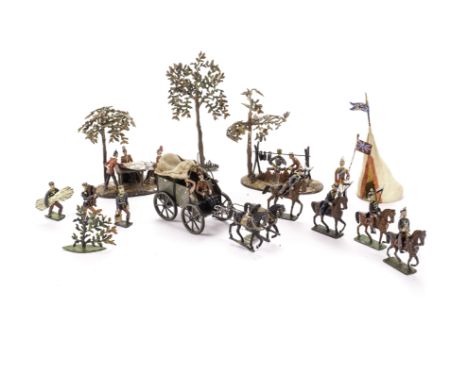
Lot 422

An early 20th century album of photographs and postcards, including India, Aden, Port Said and North America, also including an early MacDonald/Gill Underground map and an image of the schooner Madeline Constance ablaze mid Atlantic, (qty).

Lot 426

A prospect of London, coloured engraving including the Thames and St Pauls, 34 x 87cm, together with a ribbon map of the Thames.

Lot 278

Germany World War One Iron Cross, second class Third Reich twenty five years long service medal and British silk escape map

Lot 449

Daily Express war map of The Western Front 1920's

Lot 927

THE CANON CARRIGAN MEMORIAL MAP

Lot 272

Framed 'The Northern East Ridings Of Yorkshire' map, 1930's mirror, double sided painting of loco/ship

Lot 85

2 framed map prints of Hertfordshire and North and East Ridings of Yorkshire

Lot 673

Framed and Glazed Tombleson's Panoramic Map of the Thames and Medway published by J Reynolds

Lot 199

A silver cigarette case. Engraved with a map of the British Isles with major cities and listing the distances from London to the inside. Assayed Birmingham 1937, 222 grams. Condition Report. To be used as a guide only. Good condition.

Lot 340

Of First World War and railway interest. A bronze station bell from Mouslimiie Junction (8 miles north of Aleppo, Syria) along with a sketch map of Syria and presentation plaque detailing the acquisition of the bell during the last days of the campaign, Oct 1918. Bell 43cm.

Lot 1203

A Saxton's Map of Denbighshire and Flintshire, British Museum Maps, C.7.C.1.

Lot 1394

A quantity of miscellanea including Curvex map measure, clock key, miniature tool kit, pens, Drawing instruments, cut throat razors, etc.

Lot 1187

4 Ladybird books including history, a map and one other book

Lot 1412

A framed and glazed map and one other

Lot 1201

A Dennison gentleman's gold plated, keyless wind, half hunting cased pocket watch, front and dial bearing Roman numerals, subsidiary seconds dial, Waltham movement, together with an Indian white metal cigarette case stipple engraved with a map of India, verso the Taj Mahal, 13 by 8.5cm.

Lot 161

John Speede (British, 1552-1629): map of Rutlandshire, with 'Oukham and Stanford', hand coloured, showing plans of the principal towns, published by Thomas Bassett and Richard Chiswell, London, 38 by 50cm.

Lot 174

19th century and earlier maps: Thomas Kitchin; hand tinted map of Huntingdonshire, Christophorus Saxton; hand tinted map of Huntingdon and Robert Morden; Map of Devonshire, uncoloured. (3) Provenance: The Peake Collection, Old Castle Farmhouse, Stibbington.

Lot 1476

A collection of cut glass including wine glasses, vases etc and a map of Derbyshire

Lot 2354

A framed Walpoole's British Traveller map, a map of Derbyshire and a 1794 cartoon 'Popular Opinions on Public Proceedings'. (3)

Lot 2367

A framed Robert Morden map of Staffordshire

Lot 2466

A print depicting The Ashbourne Royal Shrovetide Football Game 1987, 2/475, with map and key, etc.

Lot 680

Two boxes including vintage tennis rackets in cases, a Union Jack, a military map, vintage tins, a decorative tureen and cover, and other assorted items.

Lot 274

A vintage print entitled 'Dale Street in 1850', together with a Saxtons map of Lancashire and an engraving of a view of Liverpool Town Hall.

Lot 208

Heyde size 2 - 48 mm scale - British Army Encampment, including 2 vignettes, cooking scene and officers with map table, supply wagon, fatigue party (3), Lancers (4), officer with flag, tent, bush and tree, generally G, playwear and a few minor faults, (15), supply drivers whip replaced, Lancers, 2 bottom pips missing, officer with flag has a replacement tin base,

Lot 321

King & Country Italian Forces IF09 Semovente M40-75/18 tank with Commander, IF08 Officer with map with IF07 (2) Riflemen at ease, VG, (5),

Lot 23

Two regency style convex mirrors, triple dressing mirror, copper plated tray, framed Staffordshire map, two watercolours and two coloured prints (Canterbury & Winchester). Condition report: see terms and conditions.

Lot 402

MILLHOFF, Geographia Map Series, complete, VG to EX, 50

Lot 749

FOOTBALL, signed commemorative cover for Sir Stanley Matthews Testimonial, fifteen signatures inc. Matthews, Rous, Di Stefano, Puskas, Masopust, Yashin etc., with relevant postal cachet (from the Antinoris collection); together with a repro photo from the match and a printed sketch-map of Victoria Ground (tears to top edge), FR to EX, 3

Lot 750

FOOTBALL, Stanley Matthews selection, inc. signed commemorative cover for Sir Stanley Matthews Testimonial, signed by Matthews, with relevant postal cachet (from the Antinoris collection), with signed typed letter from Stanley Rous to Antinoris thanking him for the cover; together with an original press photo (8 x 10) from the match and a printed sketch-map of Victoria Ground (tears to top edge), G to EX, 4

Lot 248

A Spy print; a map of Wales framed; framed engravings (6)

Lot 359

A 19th century map, City of Westminster, linen backed, framed, 46cm x 65cm; a poster of London, signed (2)

Lot 153

Map Collector Magazine: a complete run from issue 37-74 and sundry other issues,1978-1996.

Lot 481

A box of prints, including: a map of Northumberland; a woolwork "The Last Supper"; and a picture of "The Long Sands, Tynemouth"; etc.

Lot 134

Five Crates of Assorted Kitchenwares to include an electric world map globe, a Breville mixer, jugs, glass storage jars, saucepans, etc.

Lot 601

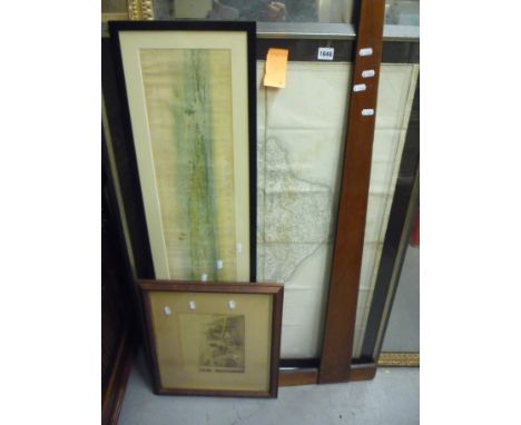
Atlas and Cyclopedia of Ireland (Part 1) & The General History (Part 2), by Joyce (P.W.) & Sullivan (A.M.). A Comprehensive Delineation of the Thirty-two Counties, with a Beautifully Coloured Map of Each, arranged Alphabetically, showing over 11,000 Cities, Towns, Villages, and Places of Public Interest. Embracing over Two Hundred Illustrations of the Natural Scenery, Public Buildings, Abbeys, Round Towers and other Romantic Places, reproduced by Eminent Artists from Photographs especially taken for this Work. Thick 4to, New York (Murphy & Mc Carthy) 1903, ptd. frontis, addit, cold. t.p., errata, 40 cold. plts. (coats of arms), cold. maps, & plts. throughout, recent green cloth cover, some wear. (1)

Lot 611

Phoenician Ireland. Dr. J. L. Villanueva. Translated by Henry O'Brien. Pub: London and Dublin 1833. First Ed.,8vo L. & D.., engd. frontis & fold. map, orig. cloth, good (1).

Lot 796

A Mid 20th Century Ordinance Survey Map of Dublin, dated 1952.

Lot 155

A late 18th century framed and glazed map of Dorsetshire, divided into hundreds by Eman Bowen, printed in London for Robert Sayer and others, June 17 '77 (later frame and folded) together with a 19th century framed and glazed print of Corfe Castle.

Lot 121

A Tray of Printed Ephemera to Include Map of Staffordshire, Print of Newport, Set of Edwardian Children Prints, Watercolour Etc.

Loading...Loading...
  • 109182 item(s)
    /page

Recently Viewed Lots