We found 109182 price guide item(s) matching your search

Refine your search

Year

Filter by Price Range
  • List
  • Grid
  • 109182 item(s)
    /page

Lot 1

Johnston, Alexander Keith (1804-1871), Atlas of Alison's History of Europe ... under the direction of Mr Alison, Edinburgh and London, William Blackwood, 1848, Oblong 4to (180 x 220mm.), engraved frontispiece, folding map of Europe coloured in outline, and 95 maps also with coloured outlines, contemporary half calf, red morocco lettering piece

Lot 1

Grose, Francis (1713?-1791), Supplement to The Antiquities of England and Wales, London, for S. Hooper, 1777, folio (320 x 225mm.), engraved frontispiece plate, illustrated title, 4 plates, 1 folding, folding map, coloured in outline, 31 in-laid maps, coloured in outline, ca. 120 illustrations, occasional offsetting, contemporary calf gilt, front cover detached, armorial bookplate of The Hon J. T. Townshend. With 'The Royal Atlas of England and Wales' (London, n.d.), & 'The Times Atlas' (London, 1900)

Lot 1

A needlework map of Europe worked by Martha Sallerthwaite, York School, 1809-coloured threads on canvas, 24.5in. x 21.25in., oval; in glazed Hogarth frame.

Lot 1

A late 18th Century embroidered map of Europe and North Africa, with embroidered floral border, 19in. x 16.75in., in inlaid mahogany oval frame.

Lot 1

A MacIntyre Moorcroft paperweight dish inscribed 'British South Africa' and depicting a Bartholomew map of Southern Africa with colonies, 9cm diam.

Lot 1

A map of Orkney and Shetland After Blaeu 1562, Amsterdam edition 40cm x 53cm.

Lot 1

A county map of Dumfries and Nithsdale After H. Moll, 26cm x 20cm.

Lot 1

A county map of Lancashire After H. Moll, hand coloured with further motifs of artifacts, 32cm x 20cm.

Lot 1

A Brittax minor microscope by Stubbs, boxed and a map planner or cartographers rule by W.H. Harling, within mahogany case. (2)

Lot 1

An engraved map of Northumberland by J. Archer, coloured by hand.

Lot 1

A reproduction map of Northumberland after John Speede, with hand-colouring.

Lot 1

An engraved map of the county of Suffolk after Joseph Hodskinson, printed for William Faden, Charing Cross, coloured by hand, 1787

Lot 1

An engraved map of England & Wales by T. Bowen, coloured by hand.

Lot 1

An engraved map of eastern England by Jansen after Mercator; an engraved mileage chart for Durham from Cox's Magna Britannia, 1720; and the title plate from Thomas Moule's English Counties Delineated. (3)

Lot 1

An engraved map of the North and East Ridings of Yorkshire with a road map on the reverse, in the style of John Ogilvie, coloured by hand.

Lot 1

An engraved map of Yorkshire by J. Cary, coloured by hand, 1793.

Lot 1

An engraved map of the North Riding of Yorkshire by J. & C. Walker, coloured by hand.

Lot 1

An engraved map of York by H. Winkles, coloured by hand; and an engraved map of Yorkshire by W.H. Toms after T. Badeslade, 1742. (2)

Lot 1

An engraved map of Durham by Thomas Moule; and an early engraved plan of Durham City, coloured by hand. (2)

Lot 1

An engraved map of Durham by J. Carey, with hand colouring; and another engraved map of Durham, 1770. (2).

Lot 1

An engraved map of Durham by J. Cary, coloured by hand, 1805.

Lot 1

An engraved map of Durham by Robert Morden, coloured by hand.

Lot 1

An engraved map of Durham by J. Cary, coloured by hand, 1809; and a miniature map of Durham. (2)

Lot 1

An engraved map of England and Wales by J. Cary, coloured by hand; mounted together with the title page from Cary's English Atlas 1793.

Lot 1

An engraved map "The Roads of England & Wales", by Thomas Kitchin, coloured by hand.

Lot 1

An early Ordnance Survey plan of Stockton; a map of the county of England, colour lithograph, unframed; and a reproduction map of Essex after John Ogilby. (3)

Lot 1

An engraved map of Richmondshire by Richard Blome, coloured by hand.

Lot 1

An engraved map of the Straits of Malaca by M. Bellin, coloured by hand, 1760.

Lot 1

An engraved map of the Indo-Chinese peninsula by Antonio Zatta E Figli, Venice, 1785, with hand colouring.

Lot 1

An engraved map of Northumberland by E. Bowen.

Lot 1

An engraved map of Durham by W. Kip after C. Saxton, coloured by hand, 1610.

Lot 1

"Tynemouth Castle", engraving by E. Finden after G. Balmer, coloured by hand; and sundry other local engraved local views, unframed; and a map, all unframed. (10)

Lot 1

AE SHAW, Lydd Church, Signed, watercolour, 9 x 14inches, and a companion picture of Impetts Corner Cottages, Lydd, a handdrawn map of Romney Marshes and another of Lydd defences, 1940 (4)

Lot 1

Seller (John); A map of Kent, 23 x 35 inches

Lot 1

Afacsimile of Andrews and Drury's, topographical map of the County of Kent

Lot 1

Atlas; Bartholomews Reduced Ordnance Survey of England and Wales, inch to 1 mile scale map of Great Britain, folio, half leather bound and Darwins Popular Atlas of the World (2)

Lot 1

Fussel (L); A journey round the coast of Kent with map, London 1818, 8vo

Lot 1

Philipott (John); Villare Cantianum or Kent surveyed and illustrated, London 1659, disbound but with folding map of Kent by Symonson, folio

Lot 1

Hasted (Edward); The History and Topographical Survey of the County of Kent, 1797, second edition, 12 volumes, 8vo plus map volume quarto, quarter leather, red and green labels, marbled boards

Lot 1

Andrews (John) and Drury (Andrew); A Topographical Map of the County of Kent, 1769, quarter calf and boards

Lot 1

Bagshaw (Samuel); History, Gazetteer and Directory of the County of Kent, 1847, 2 vols, with the coloured sheet map of the county, original cloth (lacking spines)

Lot 1

Boys (John); General view of the agriculture of the County of Kent, 2nd edition, London 1805, folding frontispiece map, half leather, marbled boards, together with two others on the agriculture

Lot 1

A ROBERT MORDEN MAP OF DARBYSHIRE, (sic) 14" X 16"

Lot 1

AN ANTIQUE MAP of the West Indies, by J Hinton, 10" x 14"

Lot 1

A German miniature New Year Card, signed "Victoria 1832" (possibly Queen) also Polite Repository for 1788, manuscript to "Sophia Gussie, Dec 1787, Queens Lodge, Windsor..with Mamma..& Lady Waldegrave", Le Souvenir...for 1823, miniature Map of Lancashire, and German "Denkmal der Freundsche", green leather box of friends" manuscript cards, c 1821-4, Royal connections likely (5)

Lot 1

Map: Dorsetshyre, hand coloured with inset of Dorchester and coat of arms, sold by Henry Overton

Lot 1

Map: Islandiae by Georgio Carolo Flando, hand coloured, slight tear

Lot 1

A French 15 section folding map of South America, dated 1814 with hand coloured boundaries.

Lot 1

C & I Greenwood. 'Map of the County of Wilts, from an actual survey made in the Years 1819 & 1820.' A coloured engraving, 22 x 27in (56 x 68.5cm)

Lot 1

Wiltshire. Five maps, including; Richard Blome, A Map of Wiltshire with its Hundreds, 7.5 x 9.75in (19 x 24.7cm); Eman Bowen and three others. (5)

Lot 1

Saxton, Christoper. 'Wiltonie' an engraved map, 16.5 x 18.75in (42 x 47.6cm), 1579 or later, but before 1642.

Lot 1

1948 Queen Wilhelmina Golden Jubilee: a fluted Delft dish moulded with central monogram and date, a Delft wine bottle and stopper, a polychromed dish for 1880-1930 and another with map of the Netherlands for 1918-19 (4)

Lot 1

Italy: a mid 19th Century pottery plate printed in brown with a map of the Franco-Italian border dispute, 212mm diameter, a pair of pottery plates for the Tripoli Campaign and another for the Ethiopian Campaign (4)

Lot 1

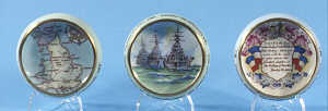
World War II: three small Paragon patriotic series circular dishes printed with a map of Britain, warships and inscribed shields, gilt rims, 86mm diameter (3)

Lot 1

World War II: a large patriotic series breakfast cup by Paragon decorated with warships and a teacup with map of Britain, both lacking saucers (2)

Lot 1

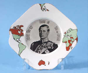
1937 Edward VIII: a square plate by Osborne China printed in brown with a military portrait, the border with a map of the Empire in colours, gilt rim

Lot 1

1959 Visit to St. Lawrence Seaway: a quatrelobe dish by Aynsley, the green ground decorated in colours with a map, colour portrait and gilded

Lot 1

'A new map of North America with the West India islands divided according to the preliminary articles of peace, signed at Versailles, 20 January 1703 wherein are particularly distinguished the United States...', published by Laurie and Whittle, No 53 Fleet Street, London, 12th May 1794. Hand coloured, on two sheets. 101cm x 116 1/2cm

Lot 1

A map of The Kingdom of Scotland, coloured engraving, 8.5cm x 12cm.

Lot 1

A cased Pack of Cards 'Belisha' by Pepys. Produced to make a helpful contribution to the 'Safety First' campaign showing street scenes etc. Cased pack of Tom Thumb Playing Cards, Motoring and Hiking Map Sect DD etc. Motor Fuel Ration Book for 1957 etc.

Loading...Loading...
  • 109182 item(s)
    /page

Recently Viewed Lots