We found 109198 price guide item(s) matching your search

Refine your search

Year

Filter by Price Range
  • List
  • Grid
  • 109198 item(s)
    /page

Lot 26

Crane (Walter, illustrator). The New Forest, its History and its Scenery, by John R. Wise, limited edition, Henry Sotheran & Co., 1883, engraved frontispiece, title-page vignette and numerous vignettes in the text on india paper, mounted, most after Walter Crane, 12 etched plates by Heywood Sumner, 1 folding map, limitation leaf and final index leaf browned, spotting to endpapers, top edge gilt, others untrimmed, original green morocco backing wood-veneer boards, spine faded and scuffed, wear to corners, 4to, and 3 others Number 44 of 350 copies only. (4)

Lot 52

Sporting and Fancy Gazette. The Annals of Sporting and Fancy Gazette; A Magazine, Entirely Appropriated to Sporting Subjects and Fancy Pursuits, Containing Every Thing Worthy of Remark on Hunting, Shooting, Coursing, Racing, Fishing, Cocking, Pugilism, Wrestling, Single Stick, Pedestrianism, Cricket, Billiards, Rowing, Sailing &c., 13 volumes, 150 engraved plates, of which 53 hand-coloured, folding engraved map (some tears), seven additional engraved titles, without June 1828 issue as usual, near contemporary previous owner signature to verso of most plates, some show-through, one or two plates and leaves detached, some light spotting and offsetting, contemporary half calf, lightly rubbed and faded, 8vo, with The Turf Herald, Or Annual Racing Calendar for 1824-28, 4 volumes in 2, similarly bound Schwerdt I, pp. 32-35. (15)

Lot 184

Stevenson (Robert Louis). Kidnapped. Being Memoirs of the Adventures of David Balfour in the Year 1751, 1st edition, 1886, 1st issue with 'business' for 'pleasure', p.40, line 11, folding map frontispiece, advertisements at rear, a few minor spots, W.H. Smith blindstamp to front endpaper, original red cloth, spine darkened and a little rubbed at ends, slight lean, 8vo (1)

Lot 15

Pontoppidan (Erich). The Natural History of Norway, 2 parts in one, 1755, large folding engraved map, hand-coloured in outline, 28 engraved plates, some lightly offset to text, title with ink stamp to upper margin, some spotting and dust-soiling, mainly to blank margins and first & last leaves, hinges cracked, contemporary calf (rubbed), rebacked and recornered, folio (1)

Lot 21

Aikin (J.). A Description of the Country from Thirty to Forty Miles round Manchester, John Stockdale, 1795, engraved allegorical frontispiece, additional title, 61 engraved maps and plates, large folding hand-coloured map and uncoloured plan conjoined and detached with reinforcements, page 389 lower corner torn away, some light spotting, Fasque bookplate, contemporary half calf, rebacked, light edge wear, 4to Provenance: John Gladstone (Sir John Gladstone of Fasque, 1st Baronet, 1764-1851, father of William Ewart Gladstone), Liverpool, 1795, his inscription to additional title. (1)

Lot 29

Morgan (William). Ogilby's and Morgan's Pocket-Book of the Roads, with their Computed and Measured Distances and the Distinction of Market and Post-Towns, 7th edition, 1732, folding engraved map of England and Wales, 94 pages of distances and lists, contemporary calf, rubbed and frayed, 12mo, together with Owen (W.), Owen's New Book of Roads or a Description of the Roads of Great-Britain being a Companion to Owen's Complete Book of Fairs, 5th edition, 1788, folding engraved map of England and Wales, frayed at margins with closed tears to old folds, 212 pages, last page torn with slight loss, disbound, plus Hunter (Joseph). Hallamshire. The History and Topography of the Parish of Sheffield in the County of York..., 1st edition, 1819, engraved frontispiece and 8 engraved plates, armorial illustrations to text, list of subscribers, occasional foxing, mostly to tissue guards, original boards with printed paper spine label, slightly rubbed and soiled, loss to spine ends and lacking upper cover, folio, and other topography interest (a carton)

Lot 18

Segur (Philippe Paul de). History of the Expedition to Russia, undertaken by the Emperor Napoleon, in the Year 1812, 2 volumes, 2nd edition, 1825, half-titles, 7 lithographed portrait and plates, folding map, some light spotting and soiling, top edge gilt, contemporary green morocco, spines lettered in gilt with Napoleonic bee emblem in compartments, joints and edges a little rubbed, 8vo, together with Copies of the Original Letters and Despatches of the Generals, Ministers, Grand Officers of State at Paris to the Emperor Napoleon, at Dresden; intercepted by the advanced troops of the Allies in the north of Germany, 1st edition, 1814, half title, folding table, some light spotting, contemporary calf gilt, joints cracking, a little rubbed, 8vo, plus Instructions in Military Equitation, and in the Elements of Field Movements of Cavalry, Adjutant General's Office, Horse-Guards, 1st June, 1819, By Authority, 20 engraved plates at rear, some spotting to mounts, contemporary ownership inscription to title, contemporary half calf, some wear, upper cover detached, 8vo, plus one related (5)

Lot 73

*Ogilby (John). The continuation of the road from London to Holy head..., [1675 or later], hand coloured engraved strip road map, 310 x 435mm, framed and glazed, together with Morden (Robert),Staffordshire [1695 or later],hand coloured engraved map, light spotting, each approximately 425 x 370 mm, framed and glazed, plus a map of Wiltshire by Pigot, 1845, and a hand-coloured lithograph coastal view of moored fishing boats, by James Duffield Harding, circa 1830s The Ogilby map is sheet 22. (4)

Lot 14

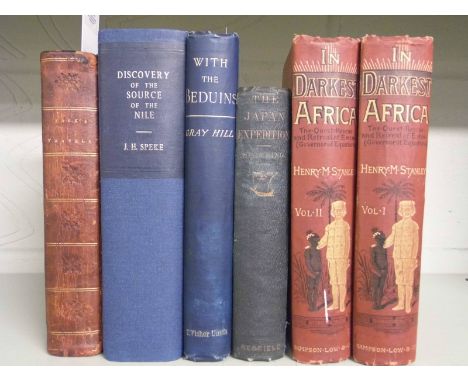
Park (Mungo). Travels in the Interior Districts of Africa: performed under the Direction and Patronage of the Africa Association, in the Years 1795, 1796, and 1796, 4th edition, W. Bulmer and Co., 1800, half-title, engraved portrait frontispiece, folding map (split to one fold), 5 plates (3 folding), contemporary half calf, front minor wear, front joint cracked, 8vo, together with: Speke (John Hanning), Journal of the Discovery of the Source of the Nile, 2nd edition, Edinburgh: William Blackwood and Sons, 1864, all plates as called for, folding map (chipped) in end-pocked, modern cloth, 8vo, Stanley (Henry M.), In Darkest Africa, or the Quest, Rescue and Retreat of Emin, Governor of Equatoria, 2 volumes, 3rd edition, Sampson Low, Marston, Searle and Rivington Limited, 1890, all plates as called for, 3 folding maps (minor repairs verso), occasional light spotting, original red pictorial cloth gilt, extremities lightly bumped and rubbed, volume 2 rolled and with small mark, 8vo, Spalding (J. Willett), The Japan Expedition. Japan and Around the World, an Account of three Visits to the Japanese Empire, with Sketches of Madeira, St. Helena, Cape of Good Hope, Mauritius, Ceylon, Singapore, China, and Loo-Choo, 1st edition, New York: Redfield, 1855, 8 tinted lithographic plates including frontispiece, spotting, browning to preface, front free endpaper chipped in gutter, original blue cloth, slightly marked, spine faded, 8vo, Hill (Gray), With the Beduins, a Narrative of Journeys and Adventures in Unfrequented Parts of Syria, 1st edition, T. Fisher Unwin, 1891, lacking 1 plate, light spotting, original blue pictorial cloth gilt, 8vo, (6)

Lot 3

Dobrizhoffer (Martin). Geschichte der Abiponer, einer Berittenen und Kriegerischen Nation in Paraguay..., 3 volumes, 1st edition, Vienna: Joseph Edlen von Kurzbek, 1783-1784, frontispiece, four engraved plates, one engraved map, and one table (some folding), map with short handling tear, some spotting to plates (lightly to map), each front free endpaper with early ink shelfmark to verso, each front pastedown with shelfmark label, contemporary sprinkled half calf gilt, covers gilt-stamped with arms of The Society of Writers to the Signet, contrasting spine labels; somewhat rubbed, extremities worn, volume 1 joints split, volume 2 rear joint slightly split, 8vo Borba de Moraes I, 228: Sabin 20413. Borba de Moraes notes the existence of this German edition dated 1783-4 (therefore predating the Latin edition of 1784) but does not appear to have seen a copy. One other copy of this rare first edition in the original German traced at auction. One copy only listed on Copac. (3)

Lot 114

Moore (John Hamilton). The Practical Navigator, and Seaman's New Daily Assistant; being a complete system of practical navigation..., the whole exemplified in a journal kept from London to Madeira, and back again to England..., the whole constructed upon a new and methodical plan, 3rd edition, 1776, folding map and folding plan, numerous diagrams and text, worm track in upper outer blank corner of first and last leaves not affecting text, contemporary ownership signature of Humphry Senhouse, dated 1782, to front pastedown, contemporary calf, rubbed, a little worming at head and foot of lower joints, 8vo This was Moore's principal work and encyclopaedic in its scope. First published in 1772, followed by a Dublin edition of 1774, and this third edition in 1776. All early editions are rare. (1)

Lot 200

Porter (Anna Maria). The Village of Mariendorpt. A Tale, 4 volumes in 2, 1st US edition, Boston, Wells and Lilly, 1821, generally toned and some foxing, hinges split, contemporary half calf gilt, rubbed, 12mo in 6s (rare), together with Arnald (G.). The River Meuse, being Delineations of the Picturesque Scenery on that River and its Banks, from the City of Leige to that of Mezieres, the Drawings were made on the spot in the Summer of 1818, 1st edition, J. & A. Arch, 1828, single-page uncoloured engraved map, 29 sepia mezzotints by Reynolds, Turner, Ward, Lupton, Dawe, Quilley and others (of 45, lacking Dinant plate 2), accompanied with 30 duplicate line etchings, engraved plans to text, some scattered spotting and dust-soiling, dampstaining mostly to margins, sewing broken and text block split, all edges gilt, contemporary morocco, boards detached and lacking spine, worn, folio (Abbey Travel 95 for the 1835 edition), plus Smith (Robert). The Universal Directory for Taking Alive and Destroying Rats, and all other kinds of four-footed and winged vermin, in a method hitherto unattempted: calculated for the use of the Gentleman, the Farmer, and the Warrener, 1st edition, printed for the Author, 1768, 6 engraved plates by Thomas Bowen of Clerkenwell, 4 folding (one expertly strengthened on verso), contemporary manuscript marginalia, contents generally soiled, M3 with lower blank corner torn away, modern quarter sheep, leather spine label, 8vo, (with contemporary manuscript recipe on small slip loosely inserted), plus other 18th and 19th century literature, history and reference, mostly leather bindings, some foreign language and odd volumes, condition is generally G/VG, 8vo/folio (55 volumes) (3 shelves)

Lot 202

Menpes (Mortimer, & Dorothy). Paris, 1909, limited deluxe edition 430/500, numerous colour and black and white illustrations, some minor toning, and spotting to endpapers, original gilt decorated white cloth, boards slightly marked, spine rubbed, 4to, together with Heron-Allen (Edward), Violin-Making, as it was and is..., 2nd edition, 1885, numerous black and white illustrations, and 3 monochrome plates, later inscriptions to front endpaper, some minor toning, original gilt decorated brown cloth, spine lightly rubbed to head and foot, 8vo, and Baines (Edward), The History of the County Palatine and Duchy of Lancaster, 2 volumes, new edition, 1868, colour folding map frontispiece to volume 1 with creases repaired with sellotape, some minor toning, uniform original gilt decorated green cloth, boards and spines slightly rubbed, large 4to, plus other 19th and 20th century UK topography, travel and miscellaneous reference, some leather bindings, mostly original cloth, G/VG, 8vo/folio (3 shelves)

Lot 815

Collectables, a 1954 map of the town of Nairobi showing aerodromes, golf courses and race courses together with 13 OS 1960s and 70s maps of London SW, SE, NW, NE, Hereford, The Solent, Bournemouth, Salisbury, Dorchester, The Chilterns, Winchester, Aldershot, Taunton and Lyme Regis (fair/gd) (14)

Lot 869

Collectables, 23 Ordnance Survey Fifth Edition (1930s) and Popular Edition maps in original storage box (no lid) together with 37 Ministry of Defence and War Office and Air Ministry maps from the 1950s and 60s. A 'How Far Instant Reading Road Map' and 30+ 1920s Encyclopaedia Britannica maps (gd) (100+)

Lot 821

Cycling Ephemera, a vintage linen Bacon's Cycling Road Map of England and Wales Sheet No 5. produced by G. W. Bacon & Co 127, The Strand together with an 1876 June 11th supplement to Vanity Fair entitled 'Cycling in Hyde Park' and another dated June 3rd 1897 'Au Bois de Boulogne' both showing notable members of the aristocracy with bicycles (fair to gd) (3).

Lot 510

Cigarette cards, Edwards, Ringer & Bigg, War Map of the Western Front, Series 2 (set, 54 cards, mixed backs) (some backs printed slightly off centre o/w gd/vg)

Lot 910

Ephemera, a mixed lot of transport related items to include a photograph of RFA (Royal Fleet Auxiliary) Tay & Tyne in 1919, a collection of 35+ b/w photos of commercial shipping, paddle steamers, tugs, naval vessels (Hood, Valiant, Belfast, Illustrious, Indomitable), a qty of 1960s Steam Rally programmes and 1950s/60s Steaming magazine, copy of 'Ploughing Engine at Work' and 'A Century of Service' 1968, 5 1960s copies of 'Railway Forum' magazine, London Underground Metropolitan Railways pocket map, 2 1951 London Transport Special Bus Service Festival of Britain tickets, 1930 leaflet London-Paris Southern Railway Services and Fares, 5 1930s and 40s copies of The Motor Cycle (mostly gd) (100+)

Lot 864

Aviation, a collection of BOAC and other aviation interest items to include 45 RPM record 'BOAC Islands In The Sun', luggage labels, 1960s route map and flight information booklet, b/w photographs (notably Imperial Airways London), 1950s/60s London Airport booklet, letters to cabin crew and a BOAC paper fan (gen gd) (40+)

Lot 870

Ephemera, transportation a very large collection of transport related items to include 1985 anniversary Bentley card album together with complete set of cards, Austen car badge, Matford booklet 'Ouvrage de Dames 1937', postcards, original b/w press photos of air sea rescues and shipping disasters (Sea King rescue 1974, wreck of the Torrey Canyon 1967 etc), vintage coach tour flyers, Triumph Dolomite handbook, framed and glazed photograph of Leander class steam engine, book 'A Living Tradition' the background story of Rolls Royce and Bentley, 1950's Torque magazine (5), 1932 Kingsbridge Motorcycle and Car Club Reliability Trials paperwork, Foxcub Kit book of the Hawker Harrier, a qty of Mechanics magazines, Southern Railway carriage map, DLR posters, Dinky Toys road sign set (unopened), adverts for BEA, Rotol, Daimler, Coventry Climax etc. (gd) (100s)

Lot 1172

Postcards, a good collection of 428 cards of Switzerland (in binder) mostly Montreux (378), & Vevey (50) inc. street scenes, views, hotels, Gruss Aus, Fantasy mountain, Winter Sport, postmark interest, washing, map, fete (Vevey 1905), Rail etc (mixed condition, fair/gd) (good mix)

Lot 509

Cigarette cards, Edwards, Ringer & Bigg, War Map Western Front (set, 56 cards) (number 1 with paper loss to front, rest gd/vg)

Lot 1042

Postcards, Cumbria / Lake District, a collection of 48 cards, RP's and printed, RP's inc. Market Sq Penrith, Glenridding Ullswater, Station Rd Keswick, Derwent Holiday Camp Keswick, also map cards, scenic views etc (gen gd)

Lot 789

Military Collectables, Boer War, a quantity of items relating to The Absent-Minded Beggar, an 1899 poem by Rudyard Kipling, set to music by Sir Arthur Sullivan and often accompanied by an illustration of a wounded but defiant British soldier, "A Gentleman in Khaki", by Richard Caton Woodville. The song was written as part of an appeal by the Daily Mail to raise money for soldiers fighting in the Second Boer War and their families. The fund was the first such charitable effort for a war. Lot comprises, silver butter knife with handle in the form of the fighting soldier, 1900 Commemorative Medal, cotton square printed with the musical score, words of the poem and map of South Africa and 2 Eyre and Spottiswoode printed poems (fair/gd) (7)

Lot 998

Postcards, Foreign, a selection of approx 60 cards of the Gold Coast with Gruss Aus style (9), map card, industry, Cocoa transport, rail station, ethnic, good street scenes, hotel, warehouses, native chiefs meeting, post office, mission factory, timber etc (mainly gd)

Lot 566

A 1960s brass framed map top table, 26" x 29"

Lot 348

CORNISH MINING, 1869 mining map of Chiverton mining district, unframed

Lot 177

ALFRED SUCKLING, "History and Antiquties of the County of Suffolk" 1846, part volume 2 only, mainly relating to Lowestoft, together with 1903 map volume of "Encyclopaedia Britannica"

Lot 1364

Johan Blaeu; Hantonia Sive Southantonensis Comitatus Vulgo Hant-shire, circa 1650, hand coloured engraved map, 42 x 51cm.

Lot 1355

FADEN (William) A Map of the Seven United Provinces, with The Land of Drent, and The Generality Lands, by W. Faden, Geographer to the King, 2nd edition, 1794, hand coloured folding map backed on linen, in original marbled slip-case with title label and hand written ownership label, 55 x 73.5cm.From a private libary.

Lot 60

AN ANTIQUE THOMAS KITCHEN MAP PLUS ANOTHER TOGETHER WITH A BIRDS EYE COLOURED ENGRAVING OF WERDEN

Lot 206

John Ogilby hand coloured map, 'The Road from Ispwich com Suffolk to Norwich and thence to Corner on the Sea Coast com Norffolk', together with two maps of Hampshire and Somerset, each framed and glazed. (3)

Lot 190

Large continental 20th century still life oil on canvas, signed, small map of Warwickshire and other pictures (7 in lot).

Lot 623

Tombleson's Panoramic Map of the Thames and Medway, new edition, published J. Reynolds, circa 1860, hand-coloured folding cloth map, approximately 125 x 25cm original gilt tooled cloth board ends

Lot 1070

Johann and Cornel Blaeu, seventeenth century hand coloured engraved map - Ischia, unframed, 44.5cm x 55cm

Lot 132

Antique hand coloured map "Carte De L'Isle De Ceylan", together with other engravings, etc.

Lot 809

Luftwaffe Flight Navigation Map for North Africa and Mediterranean, interesting double sided map of luminous waterproof material. Dated to the lower section “1.2.43”. Remains in very good overall condition.

Lot 803

WW2 German Afrika Korps 1943 Diary, good example of the issue diary / calendar issued to the German tropical troops in 1943. This example has not been written in and does still contain the original map to the reverse. Cover with palm tree and swastika with “PANZERARMEE AFRIKA” and “Kalender 1943” underneath. Good example.

Lot 828

WW1 Royal Flying Corps 1915 Dated Observers Map Board, complete with compass to the centre. Made by Houghton-Butcher London with what looks to be 1915 date. Complete with the leather strap. These map boards were often used by Royal Flying Corps Observers and also British Cavalry officers during WW1.

Lot 153

A Tray of Printed Ephemera to Include Vintage Morris Men Photographs, Map Puzzle, Bookmarks etc

Lot 106

An Oak Framed Robert Morden Map of Shropshire, 18th Century

Lot 171

A Collection of 5 Smith's Potato Crisps Glass Advertising Rectangular Dishes with Transfer Printed Design Depicting The United Kingdom Map Outline, 9.5cm x12.5cm

Lot 474

19th Century Heimburger folding map, 1856, Bratsbergs-Amt Nordl. Deel

Lot 239

Objects, to include a butlers tray, prints, United Kingdom map, Ordinance map

Lot 792

J.CARY FRAMED MAP AND TEXT OF STAFFORDSHIRE, hand tinted, double mount and framed as one, map size 27.5cm x 22cm

Lot 602

AN OXFORD PLASTIC RELIEF MAP OF WALES AND THE MIDLANDS, SERIES 1 MAP 1, together with an Oxford plastic relief map of Northern England series 3 map 4, framed, approximate size 66cm x 97cm

Lot 202

A framed and glazed 19th Century coloured map depicting Portsoken Ward

Lot 222

A framed and glazed map depicting "A New Railway map of London and Suburbs"

Lot 385

A Third Reich bronze medallion, the obverse depicting Luftwaffe eagle over a map of Germany and legend “Alles fur Deustchland”, the reverse with legend “Fur Treue Dienstleistungen in bereich des Luftgaukommandos Westfrankreich”, 40mm diam. GC

Lot 62

A hallmarked silver map of Great Britain

Lot 278

AFTER EMAN BOWEN An antique map of Berkshire divided into its hundreds 53cm x 70cm

Lot 239

Early Victorian walkers pocket map of Lancashire

Lot 38

Framed 1930's Bolton & Manchester map

Lot 149

Ortelius, Abraham. Septentrionalium Regionum descrip, a coloured engraved map, c.1570 or later, 50 x 37cm

Lot 165

Sandrart, Jacobum de - an uncoloured map of Alsatiae, 44 x 124cm, R & J Ottens - an unframed coloured engraved map of Hungarie c.1740, 56 x 93cm and Hubert Jaillot - an unframed coloured engraved map of Le Duché de Brabant, 64 x 97cm (3)

Lot 159

John Ogilby - A coloured engrave map - The Road from Oxford to Coventry Continued to Darby, 36 x 47cm

Lot 148

Ludovico Guicciardi. Hol est Civitas Hellmonda, a coloured engraved map, c.1625

Lot 135

Beschreibung Engellands Und Schottlandts, Sebastian Munster (1489-1552). Woodcut map of Scotland, England. Printed in Basle by Heinrich Petri in 1574, 27.5 x 17.5cm

Lot 621

A pair of 9ct gold and opal set 'map of Australia' cufflinks.

Lot 160

Nicolas Samson. A coloured engraved map, Hispana Antiqua, dated 1750, 50.5 x 59cm

Loading...Loading...
  • 109198 item(s)
    /page

Recently Viewed Lots