![Culiacanae, Americae Regionis, Descriptio [on sheet with] Hispaniolae, Cubae, Aliarumque Insularum Circumiacientium, Delinea](http://lot-images.atgmedia.com/SR/36385/2916721/353-2014116144059_468x382.jpg)

Culiacanae, Americae Regionis, Descriptio [on sheet with] Hispaniolae, Cubae, Aliarumque Insularum Circumiacientium, Delineatio Two great early maps of important regions in the New World are combined into this interesting composition. The first covers the region of western Mexico around Culiacan and the Spanish settlement of Villa S. Michael`s, the region noted for its silver mines. The second is the first detailed map of the Greater Antilles with detail in southern Florida, the Bahamas, and the Caribbean that is quite remarkable for the period. Ortelius based the maps on a variety of sources including Mercators world map (1569) and other maps by Guttierez and Alonso De Santa Cruz. Three strapwork cartouches and sailing ships decorate the map. Dutch text on verso with page number 8, published between 1598-1613. Lovely original color on watermarked paper with a hint of toning along centerfold and a few small stains near center of map. 13.9"" W x 19.5"" H Ortelius, Abraham 1598
We found 109198 price guide item(s) matching your search
There are 109198 lots that match your search criteria. Subscribe now to get instant access to the full price guide service.
Click here to subscribe- List
- Grid
-
109198 item(s)/page

Insulae Americanae in Oceano Septentrionali, cum Terris Adiacentibus This fine map centered on the West Indies reflects the firsthand knowledge of Hessel Gerritsz during his voyage to South America and the West Indies undertaken in 1628. It covers the same region as the Gerritsz map of 1631; from Chesapeake Bay to the northern coastline of South America, with the addition of the west coast of Central America. The nomenclature in North America is virtually identical with the notable addition of the name Virginia. The nomenclature was probably derived from a Spanish chart as it lacks any French influence. The map is richly adorned with three lovely cartouches, sailing ships, rhumb lines and compass roses. A fine impression and attractive color on watermarked paper with wide margins and light toning along sheet edges. 15"" W x 20.7"" H Blaeu, Willem 1635

A Map of the English Plantations in America This handsome map focuses on the Gulf of Mexico and extends to the Caribbean, Central America, and north to New England. The topography is indicated simply and includes an unusual Felis Lake west of Pennsylvania. The early colonial settlements of Boston, Cape Cod, James Towne, and Charles Towne are noted. On a full page of English text measuring 7.9 x 12.2"". Minor show-through of text on verso. 7.1"" W x 7.4"" H Moll, Herman 1695

A Map of the West-Indies &c. Mexico or New Spain. Also ye Trade Winds, and ye Several Tracts Made by ye Galeons and Flota from Place to Place Terrific copper engraved map covering the southern part of the United States, Mexico, Central America, the Caribbean and northern South America. Florida is shown as a stubby peninsula and the Gulf Coast cartography is still a bit confused. Locates Charlestown in the huge Carolina which includes Georgia. The map is filled with fascinating notations concerning the movements of Spain`s wealthy galleons. Their route took them into British waters off the coast of Florida and Carolina. The seas are fully engraved with the directions of trade winds added. Simple rectangular title cartouche. On watermarked paper with light toning, one spot at bottom right, and a small chip in the lower right corner of the sheet, away from the image. 7.8"" W x 10.4"" H Moll, Herman 1740

A New and Correct Large Draught of the Tradeing Part of the West Indies This two-sheet map of the Gulf of Mexico and Caribbean gives excellent detail along the coastlines. The map extends north just past the May River in present-day South Carolina. Southern Florida is depicted as a series of large islands, with a prominent R. Dais extending to the northwest. A large river and delta located where the Mississippi River should be is left unnamed, with the huge Carlile Island located at the mouth. Instead, theR. Messisepy and B. de Spirito Sancto is erroneously labeled in the area of Galveston Bay.Place names, soundings, rocks, shoals, and anchorages are identified throughout. A dotted line along the shore of the Bay of Mexico and along the eastern coast of Nicaragua indicates the area within which soundings have been measured. The map is embellished with two compass roses and three sailing ships. This map appeared in the pirated edition of The English Pilot, published by George Grierson in 1749 and by his son, Boulter Grierson, in 1767.This map is extremely scarce. We have found only two examples of it being offered for sale in the last 35 years, one of which was still bound in the atlas. A nice impression with light printer`s ink residue on the western sheet. Issued folding, now pressed with very minor archival repairs along the folds. 20.1"" W x 32.8"" H Thornton, Samuel 1749

West-Indien und Centro-America, Nebst dem Meerbusen v. Mexico This crisp map depicts the West Indies, Central America, northern South America and the southern United States. It is color-coded to depict the colonial possessions of the English, French, Spanish, Dutch, Danes and Swedes. Drawn with the typical German precision and decorated by a simple title and distance scale. Original outline color with light soiling. 7.3"" W x 9.4"" H Stieler, Adolph 1840

Les Isles Antilles Entre Lesquelles sont les Lucayes, et les Caribes Attractive map covering the southern tip of Florida and all of the Caribbean islands. There is good detail, especially on Cuba and Hispaniola, which display numerous place names and mountains in profile. Engraved by Antoine d`Winter. A dark, crisp impression, issued folding, with minor printer`s ink residue and a narrow top margin. 8.3"" W x 12.2"" H Sanson, Nicolas 1700

Americae Septentrionalis Pars IV This scarce German map of the Caribbean and Central America is part of a four-sheet map of North America. Each sheet stands alone with a decorative cartouche and full borders. The map is nicely detailed with place names in both German and English and shows many of the smaller islands, shoals and reefs. The map extends north to Cumberland Island, Georgia and west to Pensacola, Florida. Florida is quite narrow with southern Florida depicted as a series of large islands. A number of rivers and small lakes fill the peninsula. In contrast, there is little inland detail in South America, where Lake Maracaibo is given an elongated, narrow shape. The map is adorned with a decorative title cartouche, small compass rose, and Euler`s engraved ""cum privilegio"" stamp at bottom right. Watermarked paper with light soiling and a few minor creases. 13.6"" W x 14.2"" H Euler, Leonhard 1750
![[Lot of 2] Amer. Sep. Curacao. No. 74 [and] Amer. Sep. Grandes Antilles. No. 73 The Atlas Universel contained 400 maps in si](http://lot-images.atgmedia.com/SR/36385/2916721/366-2014116144122_468x382.jpg)
[Lot of 2] Amer. Sep. Curacao. No. 74 [and] Amer. Sep. Grandes Antilles. No. 73 The Atlas Universel contained 400 maps in six volumes. It was the first atlas made up of lithographed maps, and the first to present all the maps on the same scale (1: 1,641,836), with each map covering an area of approximately 20 degrees longitude (from Paris) and 6 degrees of latitude. If all the maps were joined together they would form a globe of 7.75 meters in diameter. The maps were published by subscription between 1825 and 1827, with each part containing ten maps. There was only one edition and the subscription list shows that 810 copies were sold; thus the maps are quite rare. Included in this lot are: A. Amer. Sep. Curacao. No. 74 (22.0 x 19.7""). Shows the island of Curacao along with Aruba, the northern tip of Venezuela, and the southern coast of the Dominican Republic. A large panel of text at center describes Haiti`s phsical features, government and geology. Condition: Light toning and scattered foxing. (B+) B. Amer. Sep. Grandes Antilles. No. 73 (21.6 x 18.0""). Depicts a portion of the southern coast of Jamaica along with Banc Pedro and Cayo Alburquerque. Includes a panel of text describing Jamaica`s topography and climate. Condition: Scattered foxing and toning. (B) See description See description Vandermaelen, Philippe Marie Guillaume 1825

A New Map of the Island of Cuba with Correct Plans of All the Principal Ports and Harbours It Contains This handsome sheet contains a map of Cuba surrounded by 10 small insets of the principal ports and harbors of the island. The map of Cuba shows towns, roads, rivers and mountains, with some navigational information in the surrounding waters. The inset maps depict Matanzas, Nipe Bay, Santiago de Cuba, Cienfuegos, Mariel, Baracoa, Guantanamo, Cape San Antonio, Bahia Honda, Cabanas.The Universal Museum was a very short-lived British periodical published between 1762 and 1764. Maps from this publication are rarely seen on the market and we can find no record of this map except in a few institutional collections. It would be an important addition to any Cuban map collection. A strong impression, issued folding, now pressed on watermarked paper with minor archival repairs to a few short fold separations. There is a binding tear that extends 3.5"" into map at right that has also been archivally repaired. 11.8"" W x 13.6"" H Gibson, John 1760

Carte Particuliere de l`Isle de la Jamaique Dressee au Depost des Cartes Plans et Journaux de la Marine... Superb, large-scale sea chart of Jamaica that is politically divided into parishes. The map includes remarkable detail with scores of place names and safe anchorages along the coast, in addition to mountains, roads, sugar, coffee and indigo plantations, taverns, watershed and a host of other information. The chart is embellished with two rococo-style cartouches. The engraved Depot de la Marine stamp is at bottom right, with a price of ""Prix. Trente Sols"" just below the neatline. Excellent impression and color on watermarked paper with original margins and one small abrasion in a blank area of map near bottom center. Overall a very clean and bright example. There is a bluish shadow along the centerfold in the image that is caused by our scanner and does not appear on the map. 22.3"" W x 35.2"" H Bellin, Jacques Nicolas 1758
![[Lot of 2] Carte de l`Isle de Saint Domingue [and] Ville de S. Domingue dans l`Isle de ce Nom A. Carte de l`Isle de Saint Do](http://lot-images.atgmedia.com/SR/36385/2916721/372-2014116144133_468x382.jpg)
[Lot of 2] Carte de l`Isle de Saint Domingue [and] Ville de S. Domingue dans l`Isle de ce Nom A. Carte de l`Isle de Saint Domingue, from La Harpe`s L`Histoire Generale des Voyages, circa 1758 (11.6 x 7.6""). This copper-engraved map of Hispaniola names several capes, ports, and bays running along the coast of the island, as well as identifying numerous towns and rivers inland. A compass rose capped with a fleur-de-lis radiates rhumb lines and a title cartouche draped in garlands adorns the upper left corner. Condition: On watermarked paper with minor offsetting and a hint of toning. (B+) B. Ville de S. Domingue dans l`Isle de ce Nom, from Le Petite Atlas Maritime, circa 1764 (6.4 x 8.7""). This is a very nice street plan of Santo Domingo, the present capital of the Dominican Republic. A legend indicates the location of 22 significant features on the map. Santo Domingo is the oldest continually inhabited European settlement in the Americas, and was at the time of this map`s publication a Spanish colonial possession. The chart is embellished with rococo-style cartouche, rhumb lines, and fleur-de-lys. Condition: On watermarked paper. (A) See description See description Bellin, Jacques Nicolas 1758-64

Carte des Isles des Vierges An uncommon chart focusing on the Virgin Islands with particularly good detail for a small map. The handsome chart is embellished with a compass rose, rhumb lines and a shell-shaped title cartouche. A nice impression on watermarked paper with very wide margins, light soiling and some abrasions within the title cartouche. 8"" W x 9.7"" H Bellin, Jacques Nicolas 1764

Carta de la Isla de San Christoval... Uncommon Spanish map of this Leeward island with detail of cities, towns, roads, forts, plantations, anchorages and shoals. The mountains, rivers and forested areas are depicted with a lovely two-dimensional quality. The island is divided into seven Parroquias (Parishes) and nine Quarteles (Quarters). A paragraph in the upper right corner credits Emanuel Bowen and Bellin as the cartographical sources for the map. A nice impression on watermarked paper with attractive color, light scattered foxing, and a few minor extraneous creases. There are some archival paper repairs confined to the blank margins. 14.3"" W x 15.6"" H Lopez, Juan (don) 1780

Isle St. Vincent Levee en 1773. Apres le Traite Fait avec les Caraibes. Traduit de l`Anglais This handsome copperplate map of St. Vincent is the first French edition of Thomas Jefferys` 1775 map of the island. The mountainous terrain is well defined and settlement is shown along the coastlines and rivers. The treaty to which the title refers was short-lived and it was not until 1797 that Carib resistance was finally crushed. The island was an important part of the British presence in the Caribbean due to sugar production. A note below the title explains that ""the island is 18 miles 1/8 long, and 11 miles 1/5 broad, has 22 rivers capable of turning sugar mills, and contains 84,286 acres."" The map illustrates the important rivers and shows the four parishes. The northern part of the island is noted as Terre des Caraibes where the Morne a Garou mountains dominate the topography. Watermarked paper with light offsetting and faint damp stains that just enter neatline in corners at right. 23.8"" W x 18"" H Le Rouge, George Louis 1778

La Grenade Divisee par Paroisses Levee par Ordre du Gouverneur Scott... Handsome and hard to find map of the island shows the topography by use of hachure along with roads, towns, hospitals, and plantations. A note at bottom left describes the attributes of the land and notes the fifty paces along the coast belonging to the King of England. Grenada had passed back and forth between the British and French colonial powers during the 18th century, with France ceding the island to Britain in the 1763 Treaty of Paris. The French regained control during the American battle for independence, and won the island during the 1779 Battle of Grenada. In 1783, the island was ceded back to the British with the Treaty of Versailles. The coastlines are well delineated and include the locations of safe harbor and soundings in the bays. The map has a striking compass rose orienting the map with north to the left. The map is based on Thomas Jefferys` map of the island, first published in 1775. Second French title at top: La Grenade Cedee a la Grande Bretagne par le Dernier Traite de Paix. Watermarked paper with light offsetting and a faint damp stain at top left, just entering neatline at top corner. 17.9"" W x 23.8"" H Le Rouge, George Louis 1778

Map of the Island of Tobago for the History of the West Indies A nice chart of the island showing its political divisions and considerable coastal detail. Topography is well developed. A note off the northeast coast of the island locates ""A Rock with a large Hole through it from North to South."" On a sheet with an ""1815"" watermark with faint damp stains in the bottom blank margin and remnants of hinge tape on verso. 7.1"" W x 9.6"" H Edwards, Bryan 1815

Trinidad This map of Trinidad is filled with detail, including towns, roads, rivers, and topography shown in hachure. Several large savannas are shown in areas now considered swamps. This map is part of a sheet containing four maps, each enclosed in its own borders. Engraved by Neele. Attractive original color with minor soiling. Remargined at top and left to accommodate framing. 10"" W x 11.8"" H Thomson, John 1816

Curacao This map of Curacao is filled with detail, including plantations, roads, rivers, and topography shown in hachure. Salt ponds and salt pans are also shown. The map includes an inset with a bird`s-eye plan of Fort Amsterdam. This map is part of a sheet containing four maps, each enclosed in its own borders. Engraved by Neele. Original color with light toning and soiling. Remargined at top and right to accommodate framing. 9.8"" W x 11.8"" H Thomson, John 1814

America Meridionalis Superb folio map of the continent that was added by Jodocus Hondius for publication in his continuation of the Mercator Atlas. The interior features the large mythical Parime Lacus straddling the equator and an equally interesting river system. The huge Rio de la Plata flows south from the conjectural Eupana Lacus in Brazil, while the R. Grande flows north from the same lake to join the Amazon River. The Strait of Magellan is shown, but Tierra del Fuego is part of the large southern continent. The map is beautifully engraved with a wave pattern in the oceans, which are filled with ships, sea monsters and a native canoe. The continent is flanked by two elaborate cartouches; title to the right and a large inset plan of Cuzco incorporated into the distance scale cartouche on the left. A Native American is seen with a bow and arrow in the interior. Latin text on verso. A clean and bright example with a nice impression. There are expert repairs to several separations along the centerfold. 14.1"" W x 19.4"" H Hondius, Jodocus 1623

Amerique Meridionale Delicately engraved map of South America with a charming cartouche and a simple compass rose. It presents very good information in the interior, focusing particularly on the systems of the La Plata and Amazon rivers. A remnant of the mythical Lac de Parime with the fabled Manoa o el Dorado (City of Gold) is still shown straddling the equator in Guyana. Another mythical lake, Lac de Eupana ou de los Xarayes, is depicted in Paraguay. Although his imprint does not appear on this map, this map was re-engraved from Sanson`s 1657l map by Antoine de Winter. A dark, crisp impression, issued folding. 7.8"" W x 11"" H Sanson, Nicolas 1700

De Voorgenome Scheeps-Togt van Sebastiaan Gaboto, om door de Straat Magellaan na de Moluccos te Stevenen, aan Rio de la Plata Voleyndigt This small map of the continent is filled with detail and illustrates the explorations of Sebastian Cabot. In 1525 Cabot embarked upon an expedition to calculate the precise demarcation of the Treaty of Tordesillas, which divided the lands outside of Europe between Spain and Portugal. With a fleet of four ships and 200 men, Cabot landed in Brazil and then proceeded to explore the interior of the Rio de la Plata. He constructed a fort named San Salvador and then ventured up the Parana River, establishing another fort named Espiritu Santo. Both forts are noted on the map. With the exception of a small area in central Brazil, the map is fully engraved with rivers, towns, and mountain ranges. The mythical Parime Lacus appears just north of the equator, with the fabled golden city Manoa el Dorado on its western shore. This map was published in van der Aa`s compilation of early voyages of exploration. A dark impression with attractive color, light toning, and a few spots of foxing. The top margin has been extended to accommodate framing. 6"" W x 8.8"" H Aa, Pieter van der 1710

Amerique Meridionale A very decorative 19th century map of the continent shows political divisions in outline color, with good detail of rivers and topography. The map is surrounded by steel engraved scenes including horses, Indians, jaguars, tapirs, and mining as well as female personifications at the top representing the Amazon and La Plata Rivers. The map and surrounding scenes are beautifully drawn. Excellent impression and color with marginal soiling and toning along edges of sheet. 11.1"" W x 17.1"" H Levasseur, Victor 1850
![[Lot of 3] Peru & Bolivia [and] British Guayana [and] Chili and La Plata This lot of three steel engraved maps covers a](http://lot-images.atgmedia.com/SR/36385/2916721/392-201411614427_468x382.jpg)
[Lot of 3] Peru & Bolivia [and] British Guayana [and] Chili and La Plata This lot of three steel engraved maps covers a sizable portion of South America. Size varies slightly.A. Peru & Bolivia. This map features good detail and four beautifully engraved vignettes: Swimming Couriers of Peru, Tarija, Potosi, and Lima. Parts of Ecuador, Brazil, and La Plata are visible but largely unengraved. The illustrations were drawn by H. Winkles and engraved by J.H. Kernot; J. Rapkin drew and engraved the map.B. British Guayana. This handsome map spans from the mouth of the Orinoco to the Sierra Acarai (Serra da Acari) mountain range on the border of Guyana and Brazil. It includes the national seal and vignettes of Georgetown, Ataraipu or the Devil`s Rock, New Amsterdam, and Christmas Cataract, River Berbice. The illustrations were drawn and engraved by H. Winkles; the map was drawn and engraved by J. Rapkin.C. Chili and La Plata. The area from southern Bolivia and Paraguay (left mostly blank) down to just south of San Matias Gulf is shown in this finely engraved map. It includes five vignettes: Travelling Post, The Gobernador, Water Seller of Buenos Ayres, a rattlesnake, and the Grand Square in Buenos Ayres. The illustrations were drawn by H. Winkles and engraved by W. Lacey; J. Rapkin drew and engraved the map. All three sheets feature original outline color, a few insignificant spots, and marginal toning. The second map has two tiny centerfold separations. 13.3"" W x 9.9"" H Tallis, John 1850

Terre Ferme, Nouveau Royme. de Grenade, &c. Very attractive small map of the northern part of South America, including most of modern Panama. Regional boundaries are shown along with missions, towns, major rivers and mountains. The map is adorned with a nice title cartouche. Engraved by Antoine de Winter. Attractive color on watermarked paper with some printer`s ink residue adjacent to Trinidad. 7.5"" W x 11.5"" H Sanson, Nicolas 1700

Terra Firma et Novum Regnum Granatense et Popayan Attractive map of the Isthmus of Panama and northwestern South America including most of present day Columbia and part of Venezuela. The map is based on the cartography of Hondius, which was in turn based on the work of Hessel Gerritsz. The decorative embellishments include numerous native figures, an armadillo, a llama, sailing ships and compass roses. A dark impression that is a little uneven just north of Colombia with attractive color and minor soiling. Narrow side margins, as issued. 11.4"" W x 14.3"" H Montanus, Arnoldus 1671

Terre Ferme, Nouvelle Grenade et Popayan, dans l`Amerique... This handsomely engraved map of Colombia and Panama focuses on the rivers and mountains in the region. Numerous towns identified throughout, including Bogota, Cali, Popayan, Cartagena, and Maracaibo. The map extends east to Lake Maracaibo, which is given an elongated shape. The map is adorned with two compass roses and a decorative title cartouche featuring ship merchants, goat herders, and river gods. Fine impression and color on watermarked paper with wide margins. 11.4"" W x 14.3"" H Aa, Pieter van der 1713

Brasilia Excellent map of the eastern part of Brazil based on the cartography of Hessel Gerritsz and an earlier map by Blaeu. There is extensive detail in the coastal regions with the interior left largely blank except for some conjectural river systems, including the mythical Parime Lago in Guiana and Xarayes Lago in Brazil. The Linea Aequinoctialis is prominently shown dividing the Spanish and Portuguese colonial claims. Richly embellished with rhumb lines, compass roses and sailing ships. European traders, Indians and putti surround the title and scale of miles cartouches. A dark impression with attractive color on watermarked paper. There are professional repairs to a few small worm holes and a centerfold separation confined to bottom blank margin. The side margins have been extended to accommodate framing. 11.5"" W x 14.2"" H Montanus, Arnoldus 1671
![[Lot of 2] Suite du Bresil Depuis la Baye de Tous les Saints Jusqu`a St. Paul [and] Suite du Bresil pour Servir a l`Histoire](http://lot-images.atgmedia.com/SR/36385/2916721/409-2014116144238_468x382.jpg)
[Lot of 2] Suite du Bresil Depuis la Baye de Tous les Saints Jusqu`a St. Paul [and] Suite du Bresil pour Servir a l`Histoire Generale des Voyages This pair of copper engraved maps covers the coastline of Brazil and shows the Capitaineries or hereditary harbor offices. The first map covers from Salvador to Santos, and the second continues to Maldonado in Uruguay. There is good interior detail of rivers and mountains. Size varies slightly. Minor toning and soiling. The top margins have been extended with old paper to accommodate framing. 9.3"" W x 6.8"" H Bellin, Jacques Nicolas 1757

Le Paraguay Subdivise en Ses Principales Parties Suivant les Dernieres Relaons Boldly engraved map of the region of present day Paraguay, Uruguay, northern Argentina and southern Brazil. The Rio de la Plata is the main feature of the map along with the mountains and volcanoes of the Cordillera de los Andes. A drape-style title cartouche adorns the map. Engraved by Antoine de Winter. A dark, crisp impression with a few minor spots of printer`s ink residue. Issued folding with a hint of offsetting. 8.3"" W x 10.9"" H Sanson, Nicolas 1700

Paraquariae Provinciae Soc. Iesu cum Adjacentibus Novissima Descriptio Superb map of the Jesuit province of Paraguay and the surrounding regions. Between 1609 and 1780, the Roman Catholic Society of Jesus (the Jesuits) established an autonomous Christian Indian state on the territory of present-day Paraguay, Uruguay, and parts of Argentina and Brazil. The locations of cities, missions and villages (Mission a Barbaris) are included on the beautifully engraved map. The major missionary trails are also depicted. The map is dedicated to Michelangelo Tamburino, Superior General of the Society of Jesus from 1706 to 1730. A strong impression on watermarked paper with original color in the map and later color in the cartouches. There is some extraneous creasing along the centerfold at far right and a few archivally repaired tears confined to the blank margins. 22.8"" W x 19.3"" H Seutter, Matthias 1740

Peru This attractive map covers Peru with parts of Ecuador and northern Chile. Dense with place names and topographical detail, it provides a marvelous view of the region. The map is oriented with north to the left although the compass rose incorrectly depicts north at top. The decorative title cartouche features natives and exotic fauna (llama, armadillo, snake, and a strange lizard) and the distance scale is ornamented with merfolk and military banners and flags. Galleons and a sea monster complete the lavish composition. A dark impression with attractive color on watermarked paper. There is a printer`s crease at bottom adjacent to centerfold. 11.4"" W x 14"" H Montanus, Arnoldus 1671

Der Hafen von Callo in dem Stillen Meere oder Mer del Sur nebst der Kusten... / Le Port de Callao dans la Mer Pacifique ou Mer del Sur avec les Cotes... This map depicts the area surrounding Lima and the port of Callao, extending to include the island of San Lorenzo. The topography of the land is shown pictorially, and the coastline is filled with depth soundings. Encased in decorative cartouches, both the title and a legend are in German and French languages. Issued folding, now pressed, on watermarked paper with light offsetting. Trimmed to neatline at top, with minor loss of neatline, as issued. 8.9"" W x 14.4"" H Bellin, Jacques Nicolas 1744

Le Chili. Tire de Alf de Oualle de la C. d. I. et Divise en Treize Iurisdictions Fine small version of Sanson`s important map of Chili showing the Cuyo provinces. The map is based on the descriptions of Alfonso de Ovalle, and is completed by a graceful title cartouche. Although his imprint does not appear on this map, this map was re-engraved from Sanson`s 1657 map by Antoine de Winter. A dark, crisp impression, issued folding, with very light offsetting. A binding trim at right has been replaced with old paper and an associated binding tear that just enters map border has been professionally repaired. The bottom margin has been extended with old paper to accommodate framing. 10.6"" W x 7.5"" H Sanson, Nicolas 1700

Tucuman This miniature map depicts the region west of the Rio de la Plata, known as the historical province of Tucuman. A number of cities are named, including Buenos Aires, La Plata (on the northern instead of the southern side of the estuary), and S. Miguel de Tucuman, the provincial capital. The present-day province of Tucuman is the smallest, yet most densely populated province in Argentina, and is situated in the northwest of the country. Pierre Duval was Nicolas Sanson`s nephew and pupil. He published a wide range of atlases and individual maps including a fine miniature world geography with many of the maps based on Sanson. A nice impression on watermarked paper with attractive old color that has been partially refreshed and light toning along centerfold and sheet edges. 3.9"" W x 4.9"" H Duval, Pierre 1682

Magellanique This miniature map of the southern tip of South America shows Tierra del Fuego and the Straits of Magellan and Le Maire. Pierre Duval was Nicolas Sanson`s nephew and pupil. He published a wide range of atlases and individual maps including a fine miniature world geography with many of the maps based on Sanson. A nice impression on watermarked paper with attractive color and light toning along centerfold and sheet edges. 3.9"" W x 4.8"" H Duval, Pierre 1682

Carte du Paraguay, du Chili, Detroit de Magellan, & Terre de Feu: dans l`Amerique Meridionale A large, handsome map of the southern part of the continent with good interior detail for the period. The routes of 18th century explorations are shown along with notations concerning their discoveries. The map includes two large inset. The first shows the Strait of Magellan in detail, with soundings, anchorages, rocks, shoals and a navigational note. The second is a south polar view extending to the equator, with a partially delineated Hollandia Nova and the South Pole labeled Polus Antarcticus and Australia Inaccessa. A large title cartouche, compass rose and a tiny ship decorate the map. This is the scarce first edition by Visscher, not the Covens & Mortier issue. Full original color on watermarked paper with faint offsetting and two light damp stains at top, entering less than 1"" into map image. 19.9"" W x 23.1"" H Visscher, Nicolas 1705

Exquisita & Magno Aliquot Mensium Periculo Lustrata Etiam Retecta Freti Magellanici Facies... This exquisite map of the Strait of Magellan predates the discovery of the Straits of Le Maire. It details soundings and navigational hazards in this strategic waterway. The geographic details for this map were drawn from Bernardus Joannis Monasteriensis who accompanied the first Dutch expedition to sail through the Strait in 1599-1600. That expedition is portrayed on the map by the fleet of six sailing ships in the Mar del Zur. The map is one of the most beautifully embellished maps of the Mercator atlas. It is centered on an elaborate compass rose orienting the map with north at the bottom. There are three large strapwork cartouches: the title flanked by penguins, the distance scale with an incorporated compass, and an inset with coastal view of the entrance to the strait fills the last cartouche. Whimsical sea lions, a monstrous whale, and sailing ships complete the composition. Latin text on verso, published between 1611-12. Original color that has been partially refreshed on a watermarked sheet with light soiling and some show-through of text on verso. A short edge tear at left and a centerfold separation at bottom, both confined to the blank margins, have been repaired on verso with archival materials. 13.7"" W x 18.2"" H Mercator/Hondius, 1611

Tabula Magellanica qua Tierrae del Fuego, cum Celeberrimis Fretis a F. Magellano et I. Le Maire Detectis Novissima et Accuratissima Descriptio Exhibetur This is one of the most elaborately decorated maps to focus on the tip of South America with the Strait of Magellan and Le Maire Strait. The coastlines are depicted as very mountainous, while the interior is completely without detail. Instead the region is filled with a hunting scene, exotic birds including rheas and penguins, and a quaint scene of village life. The map is further adorned with a pair of compass roses, three sailing ships, and four beautiful cartouches. The key to the map is in a strapwork cartouche held aloft by putti, while another cartouche at right dedicates the map to Gualtherus de Raet. The cartouches arrayed across the bottom of the map present a unique distance scale in checkerboard format and the title with a tribe of Fuegian natives, penguins and shells. This is the second state with a blank verso. Fine impression and color with minor soiling and a few archivally repaired tears confined to blank margins. 16"" W x 20.5"" H Jansson, Jan 1658

Fretum Magellanicum cum Terris & Insulis Adjacentibus A charming small map of Tierra del Fuego showing both the Strait of Magellan and Le Maire Strait. Inland detail is confined to a mountain range and several rivers, and the mythical Destroit de Browers is labeled at far right. Adorned with a strapwork title cartouche. Published in Johann David Zunners` rare German translation of Sanson`s L`Amerique en Plusieurs Cartes. Issued folding on watermarked paper with minor creasing. Backed in old paper to reinforce several short fold separations and to close 3 small worm holes. 8.2"" W x 9.8"" H Sanson, Nicolas 1679

Atlantic Islands This large chart contains four maps arrayed around a central scene of ""The Peak of Teneriffe."" The maps include the Cape Verde Islands, the Canary Islands, the Azores, and Madeira. There are detailed insets of part of Fayal and Lancarota. Original color on watermarked paper with light soiling and a centerfold separation that enters 1"" into map at bottom. 19.8"" W x 23.4"" H Thomson, John 1814

Mappa Aestivarum Insularum, Alias Barmudas Dictarum, ad Ostia Mexicani Aestuary Jacetium... A striking map based on the famous survey by Richard Norwood of the Bermuda Company, also known as the Somers Isles Company, in 1618. The map shows the division into the original Tribes, a short-lived term for the major shareholders in the company, that became administrative parishes. Also shown are the various landowners, with their names in a table below the map. There are many tiny houses shown on the map, locating settlements, as well as minute cannons marking the defensible points. The map is superimposed over a chart of the Atlantic with the coastlines of Britain, North America, and Hispaniola showing the location of Bermuda. Decorated with an exquisite strapwork cartouche, a coat of arms, a medallion and a compass rose. German text on verso. Excellent impression and color on watermarked paper with a professionally repaired 1"" tear just below the title cartouche. 15.6"" W x 20.5"" H Hondius, Henricus 1636

Mappa Aestivarum Insularum, Alias Barmudas Dictarum, ad Ostia Mexicani Aestuary Jacentium... This attractive map is based on Blaeu`s chart of the island (1635), which in turn was based on the famous survey by John Norwood of the Bermuda Company in 1618. The map shows the division into the original Tribes, or shares and shows the various landowners with their names in a table below the map. Bermuda was colonized in 1612, just shortly after Jamestown in 1606. Roanoke Colony had already failed by this time, but it is noted on the map and in the cartouche. The map uses Blaeu`s previous projection to show Bermuda`s correct proportion and position in the North Atlantic by superimposing this map over a smaller scale map of the Atlantic with the coastlines of Britain, North America and Hispaniola, with a tiny island of Bermuda appearing just beneath the title cartouche. The map is decorated with an aquatic themed title cartouche, including Neptune riding a pair of sea monsters, surrounded by putti. The scale of miles cartouche shows a vignette of natives and Englishmen surveying the land, and the coats-of-arms for England and Bermuda are displayed at top. A fine impression with attractive color on watermarked paper. There is a hint of offsetting and a printer`s crease adjacent to centerfold. 11.5"" W x 14.1"" H Montanus, Arnoldus 1671

A New Chart of the Vast Atlantic Ocean; Exhibiting the Seat of War, both in Europe and America Fine copper engraved chart details the trade winds and sailing courses across the Atlantic. The area covered includes most of eastern North America through northern South America, and western Europe through northwestern Africa. Ornamented with rhumb lines, a beautiful compass rose and a decorative scroll-style title cartouche. The map is filled with numerous notes and comments. A note below the title details Bowen`s sources, including Capt. Cyprian Southacks 1731 map of New England, Edward Moseleys 1733 map of North Carolina, and James Wimbles 1739 map of the Carolinas. A table at top center compares position data between this map and ""Mr. Popple`s great Map of the British Empire in North America."" Jolly calls this ""a nicely executed map."" This is the first edition and not to be confused with the 1755 state. Issued folding with just a few faint spots and one tiny hole to the east of the Azores that has been professionally repaired. A binding trim at lower right has replaced with old paper, and an associated 1/4"" binding tear has been professionally repaired. 12"" W x 16.8"" H Bowen, Emanuel 1740

Carte Reduite des Mers du Nord, pour Servir a l`Histoire Generale des Voyages This nice chart is centered roughly on Iceland and covers from the eastern shores of Canada through Greenland to Scandinavia and Britain. The coastlines are intricately drawn with coastal place names the only detail. A fine chart with decorative title cartouche and rhumb lines. A nice impression on watermarked paper. Issued folding with professional repairs to a 2"" fold separation to the right of the title cartouche and an adjacent tear that only enters the map border. 13.1"" W x 17.8"" H Bellin, Jacques Nicolas 1758
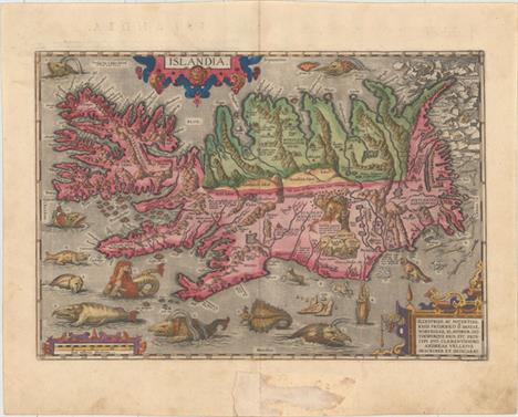
Islandia This is one of the most spectacular of all decorative maps, filling the Icelandic seas with a Boschian array of sea monsters. A lettered key on the verso gives descriptions of the creatures. Some of the beasts can be linked to a real sea creature, particularly whales and walruses, while others are wholly fantastic, such as the aquatic hyena (D) and seagoing cow (K). A Latin note near the coast explains a group of foxes holding each others tails suspended down a cliff as follows: Sly little foxes reaching for bird`s nests to rob. The upper right corner accurately depicts polar bears gamboling and fighting on ice flows, while below them an expanse of driftwood makes its way to the northern coast. Driftwood was and still is an important natural resource in coastal Iceland after it floats down from Siberia. Ambergris is noted as well (O), with the description on the verso linking it to sperm whales. The interior of the island shows its mountainous topography, including Mt. Hekla in all its volcanic fury, spewing flames and rocks. Ortelius attributed the cartography to Andres Sorensen Vedel, a Danish historian, who acquired the information from a now lost map by Bishop Gudbrandur Thorlaksson. The map was published in the 1595 Latin edition with descriptive Latin text on the verso. A fine impression with full original color on watermarked paper, light soiling in the blank margins, and a centerfold separation confined to the bottom blank margin. There is as a tear in bottom blank margin that has been closed on recto with old paper. Remnants of hinge tape on verso along edges of sheet. 13.3"" W x 19.4"" H Ortelius, Abraham 1585

Islandia This important map first appeared in the 1595 edition of Mercator`s Atlas. It is similar to Ortelius` map of Iceland (issued five years earlier) and is based on the same source - that of Bishop Gudbrandur Thorláksson. Although the map is far from accurate, it is a marked improvement on earlier maps in both content and execution. The island is depicted with its vast mountains, glaciers and fiords and the eruption in Hekla. The settlements are fairly well located and many places of interest are named. The map is decorated with a strapwork title cartouche, a sea monster and a distance scale topped with dividers. Latin text on verso. A nice impression with attractive color and marginal soiling. There are professionally repaired centerfold separations at top and bottom, only entering map 1.5"" at bottom, and a small chip in bottom blank margin has also been professionally repaired. 11.2"" W x 17.4"" H Mercator/Hondius, 1623

Septentrionalium Regionum Descrip. Ortelius based this influential map on the work of earlier authorities including Mercator, Zeno and Magnus. Of particular interest are the mythical islands of Brasil, Frisland, Drogeo, Icaria, and St. Brendan. Part of Mercator`s imaginary polar continent is depicted with a Latin note that it is inhabited by pygmies. Iceland (Islant, Thule) is basically unchanged from Mercator´s map of Europe from 1554 with the shape originated by Zeno. Greenland is separated from Europe by a wide sea and a portion of North America appears in the upper left corner with the name Estotilant. The map is adorned with a variety of very inventive creatures including a half-man, half-sea creature playing a lute. This is the seventh and final state. Latin text on verso. A strong impression with light toning, a few spots of printer`s ink residue, a minute hole in the northern ship, and a small abrasion to the east of Frisland. 14.3"" W x 19.2"" H Ortelius, Abraham 1603

Europa/ die Erst Tafel des Ersten Buchs This rare and striking woodcut map of Europe is oriented with south at the top. Although the map is a derivative of Munster`s map of Europe, first published in his Cosmographia in 1544, it supersedes Munster`s map with its elaborate decorations. The continent is filled with miniature bird`s-eye views of towns, trees, exaggerated rivers, and rope-like mountain ranges. The surrounding waters are teeming with galleons and sea monsters of every variety, reminiscent of Olas Magnus` Carta Marina. At the top of the map, to the right of Sardinia, is the sea God Triton, who plays music to calm or raise the waves in the sea. The various seas are labeled in decorative cartouches.This map was first published in Stumpf`s Gemeiner Loblicher Eydgnoschafft, which was the first national atlas of Switzerland, and the first national atlas published in Europe. Twenty-three woodblock maps were included in the first edition of Stumpf`s atlas, of which 10 were acquired from Honter`s Rudimenta Cosmografica. The remaining 13 maps, including this map of Europe, were newly engraved for Stumpf`s atlas based on the work of Waldseemuller and Munster. It is believed that Stumpf`s atlas was such an excellent example of bookmaking that it incited Munster to make significant improvements to his second edition of Cosmographia. An excellent impression with original margins, light toning along the centerfold, and a few small spots of foxing. There is marginal soiling and an archivally repaired centerfold separation in the bottom blank margin, far from map. 11"" W x 15.4"" H Stumpf, Johann 1548

Europa This miniature map of Europe extends to include Iceland, Greenland, the mythical island of Frisland and a bit of Americae Pars. French title page on verso. A nice impression with attractive color and a printer`s crease at bottom right that just enters title cartouche. 3.8"" W x 5.4"" H Hondius/Bertius, 1618

Europam sive Celticam Veterem, sic Describere Conabar Abrahamus Ortelius This is an uncommon variant of the map Jansson issued in his historical atlas. It is based on Ortelius` map of the same title, and credits him in the title cartouche. It covers Celtic Europe and is fully engraved with forests, mountains and rivers, and there are several ancient tribal and place names. The map bears the same engraver`s imprint of Everard Symonsz Hamersveldt and the cartographic content remains unchanged, but the cartouches have been simplified. Latin text on verso. Original color on watermarked paper with wide margins. There are a few short printer`s creases, a stain just west of Denmark, and minor soiling. There is moderate soiling and several professionally repaired chips and tears all confined to the blank margins. 14.1"" W x 18.9"" H Jansson, Jan 1638
![[Pascaart van Europa op Wassende Graaden door Dirck Rembrantsz van Nierop] This is the central portion of an extremely scarc](http://lot-images.atgmedia.com/SR/36385/2916721/449-2014116144348_468x382.jpg)
[Pascaart van Europa op Wassende Graaden door Dirck Rembrantsz van Nierop] This is the central portion of an extremely scarce oversized copperplate chart of Europe, extending to include the majority of the North Atlantic. The full plate was listed in an advertisement in Doncker`s Nieuw Groot Stuurmans Straetsboeck, published in 1664, and was to be printed on either vellum or paper. The advertisement explains that the chart would be fit to put in a golden frame as a ""jewel"" or prize decoration in the home. Only one example of the full chart is known to be in existence, a hand-colored vellum example at the Maritime Museum in Rotterdam. As the oversized chart would not fit in a folio atlas, Doncker masked different portions of the chart in order to print the chart on paper for several of his atlases. The British Library has an example of this masked chart in a Doncker atlas published in 1696, Nieuwe Groote Vermeerderde Zee-Atlas ofte Water-Werelt. However, the chart in the British Library exemplar is shifted slightly to the west and includes a title added below the ships at bottom left: ""Pascaert van het Westerlyckste Deel van Europa."" This is the only known copy of this atlas. Another example of the masked chart exists in a 1693 Doncker atlas in the Biblioteca Nacional in Madrid, with the chart shifted farther north.Doncker`s oversized sea chart is largely based on Jacob Aertsz. Colom`s four-sheet chart published in 1651, Der Groote Noord Zee Wassende Grade Pas Caart, which extends further north and west than Doncker`s chart (see Burden #302). The coastlines of Europe and northern Africa are filled with place names, while the coats of arms of various nations are placed within the interior. In Scandinavia is a charming depiction of horned sheep in a pasture. Along the right edge of the sheet are the beginnings of an elaborate vignette and the title cartouche.The Prime Meridian is based in the Canary Islands. Iceland, Jan Mayen Island, and the mythical Enchuyser Eylant are depicted just west of the Prime Meridian in the North Atlantic, with numerous place names and depth soundings surrounding Iceland. This chart also gives good detail of Greenland, which has a partially delineated coastline to the south and a projected coastline to the northeast. Interestingly, there are significant differences between this chart and all of Doncker`s other charts representing Greenland, Iceland, and Davis Strait, published between 1659 and his death in 1699. This chart gives two additional place names in Iceland: Lokula Haske in the south and Suer in the east. In addition, the shape of Greenland and place names along the coastline are starkly different in this map versus his other works. This map has place names concentrated on the western coast (partially truncated in this example), and depict the island with a more accurate shape. In contrast, Doncker`s other charts of Greenland show the island with a pointy southern tip that slants to the southwest, with several large islands at the southern end. These differences clearly show that this chart was based on Colom`s chart, whereas Doncker`s other maps representing Greenland were based on Pieter Goos` chart of Greenland, Iceland, and Davis Strait, first published in 1650 (Pascaerte van Groen-Landt), which itself was based on Theunis Jacobsz` chart of Greenland. A nice impression with minor soiling and light damp stains at right and left. There are 2"" centerfold separations at top and bottom, as well as several short tears and one long tear extending from northern Africa to Ireland that have been closed on verso with archival materials. 19.9"" W x 23.7"" H Doncker, Henrick 1690

Carte Itineraire et Politique d`Europe d`Apres les Derniers Traites de Paix avec les Plans des Principales d`Europe This large-scale map of Europe depicts the political boundaries subsequent to the Napoleonic Wars. There is also excellent detail of towns of various sizes and roads throughout. The map is adorned with a drape-style title cartouche held aloft by the angel of Fame, blowing her trumpet. Bird`s-eye plans of 10 key cities of Europe flank the map, including Paris, London, Vienna, St. Petersburg, Istanbul, Rome, Naples, Madrid, Berlin and Copenhagen. Each of the plans features a note on the city and a numbered key identifying important locations and buildings.The map is dissected into 24 sections and mounted onto linen with green ribbon edging and marbled paper board covers. The map folds into a matching marbled paper slipcase. A very nice example with original outline color, a few tiny spots, and very minor toning along a few folds. The covers and slipcase show light wear and rubbing. 29.4"" W x 43.3"" H Maire, N. 1818
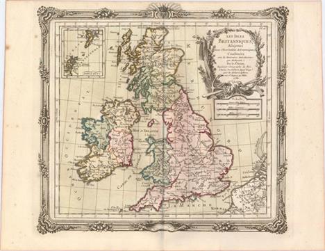
Les Isles Britanniques, Assujetties aux Observations Astronomiques A decorative and simply detailed map depicting topography with major place names noted. An inset of the Shetland and Orkney islands and three distance scales are also featured. The cartouche is decorated with garland and an anchor with two oars. The beautifully engraved picture-frame border was printed from a separate plate, and was designed in a rococo-style. A nice impression with original color, just a hint of color offsetting, and a few minor spots of foxing confined to the blank margins. 11"" W x 12.25"" H Brion de la Tour/Desnos, 1766
![Anglesey [on sheet with] Wight Vectis Olim [and] Garnesay [and] Iarsay Very handsome folio sheet with four maps depicting th](http://lot-images.atgmedia.com/SR/36385/2916721/456-201411614442_468x382.jpg)
Anglesey [on sheet with] Wight Vectis Olim [and] Garnesay [and] Iarsay Very handsome folio sheet with four maps depicting the English islands Jersey, Guernsey (with Castle Cornet noted), Wight and Alderney. Each map with its own decorative title cartouche and distance scale. Latin text on verso. A fine impression with attractive color, wide margins, and a long tear adjacent to centerfold that has been expertly and almost invisibly repaired. 12.7"" W x 17.3"" H Mercator/Hondius, 1623

Warwicum, Northhamtonia, Huntingdonia, Cantabrigia, Suffolcia, Oxonium, Buckinghamia, Bedfordia, Hartfordia, Effexia... Mercator`s great map of the southeast region of England including the British Channel and London. The map includes London, Kent, Oxford and Cambridge, as it covers the region between Norwich in the north and west to beyond the Isle of Wight. The sea is engraved in a moiré pattern and the title is included in a fine strapwork cartouche. Latin text on verso. A nice impression with attractive color, light toning, and faint scattered foxing primarily confined to the blank margins. There are light damp stains in the bottom blank margin. 14.6"" W x 18.5"" H Mercator/Hondius, 1623
![[Lot of 4] The Environs of London [and] A New Map of the County of Surrey [and] A Map of the Hundred of Eyhorne [and] Essex](http://lot-images.atgmedia.com/SR/36385/2916721/459-201411614447_468x382.jpg)
[Lot of 4] The Environs of London [and] A New Map of the County of Surrey [and] A Map of the Hundred of Eyhorne [and] Essex Reduced from the Ordnance Survey This lot includes four maps from over a century of cartographic history detailing areas in southeastern England in and around London.A. The Environs of London, by Joseph Hutchins Colton, dated 1855, black & white (14.6 x 12.3""). This detailed plan covers the city and its surroundings from Southgate south to Mitcham and Kingston east to Woolrich. The River Thames is central, and several parks, railroads, marshes, hills, bridges, and more are shown. Condition: A crisp impression with two small chips and a few edge tears, all of which are confined to the blank margins, with the exception of one that grazes the neatline at bottom. (A) B. A New Map of the County of Surrey, by Charles Smith, dated 1808, hand color (19.8 x 17.6""). This is the second edition of this comprehensive map of Surrey that extends to include a small plan of London. Within the county itself are numerous towns, farms, roads, canals, churches and chapels, parks, railroads, and more. There is nice topographical detail. The county is subdivided into fourteen hundreds (although Copthorne and Effingham are here counted as one), and a key at bottom right explains the different symbols used throughout the map. A compass rose appears above the county. Condition: Issued folding on watermarked paper with light toning and offsetting. There are some edge tears and fold separations that enter into the image, most of which have been repaired with archival materials. (B)C. A Map of the Hundred of Eyhorne, by Edward Hasted, circa 1782, hand color (15.1 x 19.6""). This elegantly engraved map focuses on Eyhorne, the largest hundred in the county of Kent. There is nice detail of the wooded, hilly terrain, and towns, roads, mills, heaths, parsonages, and castles are located. Bordering hundreds are left mostly blank with the exception of some town names. Ref: cf. Shirley (BL Atlases) #G.HAST-1a #16. Condition: Issued folding with light offsetting. Backed in tissue to repair several fold separations and edge tears. There is minor loss of image near the center of the map. (B) D. Essex Reduced from the Ordnance Survey, by Anonymous, circa 1890 (17.9 x 11.9""). This informative map delineates the county of Essex, located to the northeast of London, which appears at bottom left. The county is divided into West, East, and South divisions, and boroughs, towns, railways and stations, roads, rivers, and more appear. There is nice detail along the coasts, with piers, harbors, mudflats, a light vessel, and other notable features shown. Condition: There are a few small unobtrusive spots as well as an edge tear at right and two short centerfold separations in the top and bottom blank margin that have been closed with archival tape on verso. (A) See description See description 1782-1890

The Road from Exeter to Barnstable & Thence to Ilsarcomb Co: Devon... This attractive strip-style map covers 76 miles of roads in Devonshire. It is in the pictorial style pioneered by Ogilby with the road laid out in several ribbon-like panels. Each of the six panels has a decorative compass rose to orient the traveler. The route travels from Exeter through Crediton Kerton, Chimleigh, Barnstable, Ilfarcomb, Bedford, and on to Torington. The map locates three beacons in hilly regions, ostensibly for night travel. The strapwork title cartouche features the royal coat of arms and grapes. An excellent impression on watermarked paper with good margins, a tiny abrasion at far right, and a small rust stain at left. 12.6"" W x 17.1"" H Ogilby, John 1675

Map of London and Its Vicinity This magnificent map of London centers on the River Thames and spans from Kensington Palace and Hyde Park to the East India Docks and Greenwich Park. It is filled with detail, showing boroughs, streets, parks, railways, canals, docks, gardens, and more. Among the sites of interest located are St. Paul`s Cathedral, the Houses of Parliament, Westminster Abbey, the site of the Great Exhibition of 1851, London Bridge, and Buckingham Palace (here called The Queen`s Palace). A nice impression issued folding with numerous fold separations that have been closed on verso with archival tape, light offsetting, and one small chip at top and a few short edge tears. The top margin has been trimmed to the neatline above the title. 19.1"" W x 35.5"" H Lowry, J. W. 1854
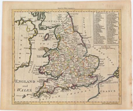
England and Wales This elegantly engraved map of England and Wales also extends to show portions of Scotland, Ireland, the Netherlands, and France. England and Wales are divided into 52 counties, which are named in a key in the top right corner, with numerous towns and cities identified within each one. Issued folding on watermarked paper with a couple of faint spots within the image and light toning mostly confined to the blank margins. 7.4"" W x 8.5"" H Walker, John 1797
-
109198 item(s)/page