Barrow (John) Voyages of Discovery and Reasearch within the Arctic Regions from 1818 to the Present Time .., John Murray, 1846, portrait frontis, two charts (the large folding chart torn without loss), original cloth (gutter gaping in places, spine head worn); Fisher (Alexander), Journal of a Voyage of Discovery to the Arctic Regions, in his Majesty's Ships Hecla and Griper, in the Years 1819 & 1820, Longman Hurst .., 1821, third edition, folding frontis. chart, a map and five plates as called for, half calf (rubbed); with one other (3)
We found 109198 price guide item(s) matching your search
There are 109198 lots that match your search criteria. Subscribe now to get instant access to the full price guide service.
Click here to subscribe- List
- Grid
-
109198 item(s)/page
A novelty carved oak wall mounted sundial, in the form of a Norman soldier holding a shield shaped sundial inscribed "John Drayden of Ye Towne, Windsor, Ano Dom 1657", standing on a circular roundel with applied metal plaque with central Roman numerals on a circular segmented map engraved with countries.
A large collection of vintage folding maps to include Bartholomew's Map of England And Wales (31 sheets), Scotland (7 sheets), map of Central and East Africa, Tourist and Cyclists, HArrogate, Oban District, Orkney, Geological map of the British Islands, Wick, Ordnance Survey Thurso and Reay, London Transport Central Buses, Bacon's County map and guide Lincoln, Scarborough, Orkney Islands, Plymouth and Torquay etc., Rugby, Exmoor and many more. Also a larger folio of coloured paper maps.
A believed late 19th century Victorian large oak six-drawer architects plan / map chest of drawers in two parts. flanked on the right with six deep pockets for rolled maps / plans, applied brass cup handles and name pockets raised on plinth base. Measures: 88cm high x 133cm wide x 84cm deep.
A quantity of reports, booklets, magazines and other items to include The Kenya Settlers Cookery Book and Household Guides, Ministry of Aviation Photographic Study of the origin and development of fatigue fractures in aircraft structures, Land Tenure in Buganda, Townsmen in the Making Kampala and its suburbs and a framed map of East Africa
[Signed Letter] A Narrative of The Siege of Kars and of The Six Months Resistance by the Turkish Garrison under General Williams to the Russian Army together with A Narrative of Travels and Adventures in Armenia and Lazistan…by Humpry Sandwith, published John Murray 1856 first edition with engraved frontispiece, title and folding map, cloth with signed autograph letter from the author
[Childrens] Theodore or The Crusaders by Mrs. Hofland published John Harris (c1830s) with engraved plate in leather backed boards, Aunt Judy’s Tales by Mrs. Alfred Gatty Illustrated by Clara S. Lane 1861 in gilt lettered cloth. Geography and History Selected by A Lady for the Use of Her Own Children 1843 with folding Map of the World and other plates, with a copy of Joan Of Arc by Robert Southey 1853 with engraved title & portrait (4)
A collection of ephemera relating to Cardiff Docks including a handbill for the opening of Eastern Bute Dock, Cardiff, 1855, an invitation and official map to the opening of the Roath Dock, Cardiff 1887, luncheon menus and a piece of tartan ribbon from the official opening, Cardiff Railway Company Bute Docks shipping list July 15th 1907, two postcards featuring the Royal Yacht opening new dock, Cardiff, entered for sale by direct descendants of Thomas Newland Rosser (1857-1935), dockmaster at Bute Docks (later the Cardiff Railway Company). He was apprenticed in 1872, gained his master's certificate in 1880, in 1885 he was appointed deputy dockmaster and in 1896 dockmaster. His father was also a pilot in Cardiff, having been so for around 40 years. Thomas Newland Rosser hosted Captain Scott and the Terra Nova before setting off on their Antarctic expedition. He was also present at two visits of the Royal Yacht Victoria and Albert III
The Whole Art of Navigation; in five books containing I: The Principles of Navigation and Geometry; II: The Principles of Astronomy; III The Practical Part of Navigation; IV: The Description and Life of Such Instruments as are useful in taking Observations at Sea; V: Useful Tables in Navigation wherein those of the Suns and Stars Declination and Right Ascension &c are Newly Calculated; by Captain Daniel New-House, Printed for Tho. Passinger at Three Bibles on London Bridge, and Tho. Sawbridge and E. Playford in Little Britain 1686, with Engraved pictorial title page, printed title in red and black, numerous engravings, diagrams, plans, charts and a folding map. Leather-bound boards (worn and detached) with raised bands
Robert Morden (c. 1650 - 1703), by and after, two-page map, Darbyshire (sic, Derbyshire), [Published and] Sold by Abel Swale, Awnfham (sic) and John Churchill, London [n.d., 1695], hand-coloured copperplate engraving, 38cm x 435.5cm; another similar, monochrome, 18th century, 36cm x 40.5cm [2]
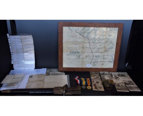
Medals and Militaria, WW1, Royal Warwickshire, Too Young/Assumed Identity, Gas Warfare Instructor in Washington, group of three, 1914-15 Star, Great War and Victory Medals, named to 1422 A. Sjt. W.A. Price, R. War. R. [Royal Warwickshire Regiment], the Star named to the then Private, Pte. W.A. Price, R. War'. R., erroneous ribbon arrangement but present; his 1907 pattern bayonet, 43cm blade inscribed Wilkinson, Pall Mall, surmounted by crowned GR cypher, stamped with War Department markings to verso, two-piece wooden grip, scabbard with khaki fittings, 57.5cm long overall; framed Trench map, Fifth Army Situation Map, 5 p.m. 20th August, 1917, 39.5cm x 49.5cm; Army Reserve (Special Reservists) 6 Years' Service; 1915 Calendar and Map of Flanders and Northern France; certificates: Employment During the War, Character and Discharge; send from the Front in 1918 to America, to instruct in Washington and New York vis-à-vis gas warfare and intelligence work: Certificate of Identity, with signed photo, from the New York Office of the British Military Attaché, signed, stamped and dated 7th September 1918, Movement Order dated 7th October 1918 directing the then Sergeant William Arthur Price from Washington to New York from the British Military Mission, D.C., etc; postcards, WW1, humour: b/w (5) and coloured (2); personal possessions: gilt brass vest case, box of Cru-Steel Star Razor Blades, brown leather change wallet; (archive) William Arthur Price was the assumed wartime name of Harold Price he was too young to enlist and so assumed his predeceased brother's name and birth date, as evidenced by the carbon copy of a handwritten letter from is his son/daughter and might also explain why his Certified Copy of Attestation though filled in is not signed by a magistrate or attesting officer.
Smooth edge. Diakov 30.1 (R3), SM--. Laureate, draped and cuirassed bust of Peter right, signed M on truncation / Soldier with lit grenade scaling siege ladder, river-god at left, topographical map of the city and fortifications in the background. Extremely rare, original lifetime medal of Peter. Small reverse rim tap, obverse hairlines. Very fine
Cartography - Olympia 1936: Map of Berlin, a thirty-two fold chromolithographic map of the German capital, the front fold with the Olympic Rings and the Brandenburg Gate, the margins with guides and instructions for international visitors to the city and Olympiad, 82cm x 79cm overall; England _ East Coast: River Tyne, Jarrow Slake to Elswick, Soundings by Commander H.J. Gedge, R.N., Topography from the Ordnance Survey [...], large corrected edition, Published at the Admiralty, London 1948, 53.5cm x 70cm; others maps, British Grand Fleet in the Great War, Complete Chart of North Sea Movements 1914 - 1918 and Air Raid Map of the Metropolitan Are and Central London, [4]
Football/Cricket/Motor Bike, a Peter Crouch presentation, a framed and glazed map signed by Rochdale FC, three photographs plus a signature (480mm x 480mm) James Toseland action photograph (470mm x 370mm) with a signature, two sets of cigarette cards cricketers and a photograph of race horse Montjeu winner in 1999 of three major races al framed and glazed
NOTTINGHAMSHIRE, AFTER MORDEN (ROBERT), a hand coloured reprint, approximately 36cm x 42.5cm, 'A View Accurate and Correct Map of Nottinghamshire, Engraved from an Actual Survey and other Improvements by E. Sudlow', approximately 45cm x 38cm and 'A New Map of The County of Nottingham, Divided into Hundreds', printed for C. Smith, hand coloured, approximately 55cm x 49cm, all three framed and glazed (3)
MOUNT EVEREST REGION, a Royal Geographical Society scale 1:100000 colour map, printed by Cook, Hammond & Kell Ltd, circa 1975, titled in the margin 'TREK IN NEPAL 2-22ND MAY 1981 - PARTY LED BY MR A. GREGORY', with route marked in black ink and signed by Alfred Gregory and Suzanne G. Gregory, mounted, framed and glazed, 68cm x 76cm, Alfred Gregory (1913-2010) was a mountaineer, explorer and professional photographer, he was a member of the 1953 British Mount Everest Expedition in charge of stills photography and personally reached 28,000 feet in support of the assault on the summit
ANON, 'THE WORLD ACCORDING TO THE LATEST DISCOVERIES', a hand coloured engraving double hemisphere World map, similar to Thomas Jeffries map of the mid 18th Century, with vignettes to corners or four seasons of four elements, approximately 20cm x 37.5cm (condition: framed and glazed, a damp patch is visible to mount in bottom left hand corner, fold to centre and various creases throughout print
A SMALL GROUP OF PICTURES AND PRINTS, etc to include an oil painting of a stream flowing through open countryside, unsigned, approximate size 35cm x 45cm, a pastel drawing of mountains and a cloudy sky, signed G R Brown 7/07, a map of Staffordshire by Emanuel Bowen, topographical engravings of Lichfield, together with other pictures etc (one box and loose)
BRITISH ISLES, JANSSON (JAN) 'MAGNAE BRITANNIAE et HIBERNIAE Nova DESCRIPTIO', a mid 17th Century engraved map, hand coloured, Royal Coat of Arms upper left, Orkney Isles inset to cartouche upper right, Latin text verso, unmounted and unframed, some staining, paper repair on bottom edge to vertical centre fold, a few tears around margin, some creases in centre and top edge, paper size approximately 49.2cm x 57.7cm, image size approximately 42.5cm x 54.1cm
BRITISH ISLES, BLAEU (JOHN) 'INSULAE ALBION et HIBERNIA cum minoribus adjacentibus', a mid 17th Century engraved map, hand coloured, Ptolemaic projection, Spanish text verso, centre fold, stained, crease in margin upper right and upper left, some small tears on left hand edge, paper size approximately 49.4cm x 63cm, image size approximately 38cm x 44.3cm
-
109198 item(s)/page