We found 109198 price guide item(s) matching your search
There are 109198 lots that match your search criteria. Subscribe now to get instant access to the full price guide service.
Click here to subscribe- List
- Grid
-
109198 item(s)/page

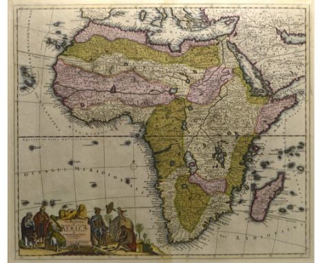
Lot 1072
AFTER FREDERICK DE WIT; 'Novissima et Perfectissima Africae Descriptio', a late 17th century copper engraved hand-coloured map of Africa, later issued by R. & J. Ottens, 48.8 x 56.8cm, framed and glazed.Additional InformationWaviness to the paper, central vertical fold/crease, spotting and foxing particularly to corners and edges but present in varying degrees throughout.
![AFTER JOHANN BAPTIST HOMANN; 'Totius Africae Nova Repraesentatio [...]', an early 18th century hand coloured engraved map of](https://cdn.globalauctionplatform.com/680b153e-6c63-4eed-ba91-aa0f0118148b/b5531200-6fa9-442b-96d3-aa1c011db691/468x382.jpg)
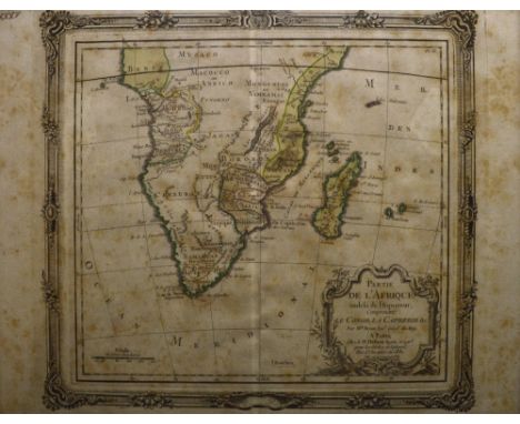
Lot 1073
AFTER JOHANN BAPTIST HOMANN; 'Totius Africae Nova Repraesentatio [...]', an early 18th century hand coloured engraved map of Africa, circa 1720, title cartouche decorated with native peoples, wildlife and landmarks, pub. Nuremberg, 48.5 x 57cm, framed and glazed with Frank R. Thorold Ltd of Johannesburg label verso.Additional InformationCentral fold/crease, some foxing, spotting and minor discolouration but colours remain distinct.
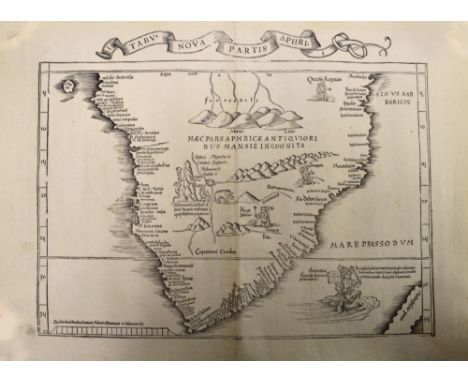
Lot 1074
AFTER MARTIN WALDSEEMÜLLER; 'Tabula Nova Partis Aphri', an early to mid-16th century map of South Africa with Latin text and illustrations, uncoloured, map approx 30 x 42cm, unframed.Provenance: Purchased from Frank R Thorold of Johannesburg in 1997.Additional InformationCentral fold, some foxing, spotting and marks, the right hand side is lifting from the central joint at both the top and the bottom of the vertical fold with a few small surface losses.
![AFTER GUILLAUME SAMSON; 'Iudaea Seu Terra Sancta, In Suas Duodecim Tribus Divisa [...]', a late 18th century copper engraved](https://cdn.globalauctionplatform.com/680b153e-6c63-4eed-ba91-aa0f0118148b/67ab1ad0-9e1b-4364-9846-aa1c011db873/468x382.jpg)
Lot 1075
AFTER GUILLAUME SAMSON; 'Iudaea Seu Terra Sancta, In Suas Duodecim Tribus Divisa [...]', a late 18th century copper engraved hand coloured map of Judea and the Holy Land, cartouche to upper left showing Moses holding the Tablets of Law and cartouche to lower right depicting Adam and Eve in the Garden of Eden, pub. by Jaillot Paris 1677, 52.5 x 84cm, framed and glazed. Additional InformationCentral vertical fold/crease, foxing and spotting throughout, some fading to colours and staining.
Lot 1077
AFTER LOUIS BRION DE LA TOUR; 'Partie de L'Afrique Audelà de L'Equateur, Compremant le Congo, la Cafrerie & C', a mid-18th century copper engraved hand coloured map of Africa, pub. Sr. Desmos Paris 1766, map 23 x 25.5cm, framed and glazed. Additional InformationHeavily foxed and browned, later page no. inscription upper left, central crease/fold.
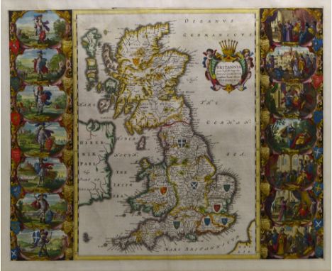
Lot 1078
AFTER JAN BLAEU; 'Britannia Prout Divisa Fuit Temporibus Anglo-Saxonum Praesertim Durante Illorum Heptarchia', a mid-17th century copper engraved map of the Saxon Kingdoms of Britain as featured in Volume 4 of 'Atlas Novus' with 14 highly detailed and finely hand-coloured vignettes and further hand-colouring to the map and cartouche, pub. Amsterdam c.1645, approx 41 x 52cm, framed and glazed.Additional InformationCentral fold/crease, some waviness to the paper, some spotting, pronounced crease mark to the lower left of the map and again to the lower left of the left column of vignettes, some further lines or creases, spotting and discolouration however colours remain distinct.

Lot 1079
AFTER HENRICUS HONDIUS; 'Africae Nova Tabula', an early-mid 17th century copper engraved hand-coloured map of Africa with detail of galleons and mythic sea creatures, dark impression, 37.7 x 50.3cm, framed and glazed.Additional InformationA dark impression as stated, central fold/crease with marks following it, spotting and foxing and discolouration throughout.

Lot 1080
AFTER ABRAHAM ORTELIUS; 'Africae Tabula Nova', an early 17th century copper engraved hand-coloured map of Africa from the Spanish text edition of 1612, 37.5 x 50.2cm, framed and glazed.Additional InformationCentral fold/crease, discolouration and foxing, some waviness to the paper, some printing errors, bleeding of text.

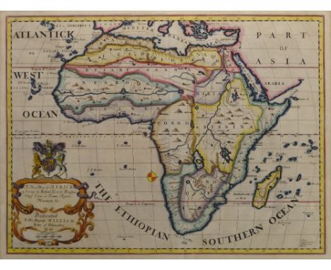
Lot 1082
AFTER EDWARD WELLS; 'A New Map of Africk Shewing its Present General Divisions Chief Cities or Towns, Rivers, Mountains &c Dedicated to His Highness William Duke of Gloucester', a circa 1700 copper engraved hand coloured map, R. Spofforth sculp., 36.8 x 50.7cm, framed and glazed.Additional InformationCentral vertical fold/crease, some spotting and foxing particularly to edges, colours remain distinct.

Lot 1083
An 18th century Italian copper engraved hand coloured map of the Cape of Good Hope, 'Carta Geografica Del Capo Di Buona Speranza', 32.5 x 42cm, and a Dutch engraving depicting the Cape of Good Hope, 'Gezigt Van De Kaap De Goede Hoop' with key of landmarks to lower section, approx 26.5 x 36cm, both framed and glazed (2). Additional InformationRegarding the map, some old print marks, some discolouration and spotting, later inscribed 117 to upper right, engraving also with some spotting and discolouration.
![AFTER NICOLAS SANSON; 'A Mapp of the Higher and Lower Aethiopia Comprehending ye Several Kingdomes [...] by Monsieur Sanson G](https://cdn.globalauctionplatform.com/680b153e-6c63-4eed-ba91-aa0f0118148b/48409d90-9c21-4aa0-b433-aa1c011dbfcb/468x382.jpg)
Lot 1084
AFTER NICOLAS SANSON; 'A Mapp of the Higher and Lower Aethiopia Comprehending ye Several Kingdomes [...] by Monsieur Sanson Geographer to ye French King', a late 17th century copper engraved hand-coloured map of Africa, dedication 'To the Right Worshipful S. R. William Glynne of Bissister in Oxfordshire [...]' upper right, Francis Lamp sculp., 29.8 x 40.7cm, framed and glazed. Additional InformationBrowning to paper, foxing, some fading to colours, some waviness to paper and crease/fold marks.

Lot 1085
An unusual and large rectangular coloured map, 'Nyasaland Protectorate Central Africa' printed by Vincent Brooks, Day & Son Ltd of London, with profuse illustrations of native people, landmarks, flora, fauna and travel routes, scale 8.89 miles to 1 inch, 146.5 x 59.5cm, framed and glazed. Additional InformationIn good well preserved condition, colours are strong, only some light waviness but overall in good original condition.


Lot 1092
AFTER ROBERT MORDEN; an early 18th century copper engraved hand coloured map, 'The County Palatine of Lancaster', sold by Abel Swale Aunsham & Iohn Churchill, approx 41 x 35.7cm, framed and glazed. Additional InformationCrease to upper right, vertical fold/crease marks, some crinkling and waviness to the paper, small loss lower left corner, some discolouration.

Lot 201
Map - London, Westminster and Southwark as in the Olden Times, by William Newton, "Shewing the City and its Suburbs with the Churches, Monasteries and all the important Buildings as they stood in the Reign of Henry VIII before the Reformation", published by Wm. Newton & Bell & Daldy, London 1855, large folding map, sectionalised and laid on linen, contemporary outline colouring, elaborate decorative borders, 41 x 55in. (104 x 140cm.)., *Condition: Some wear and losses along edges and to corners of paper sections throughout. 4in. horizontal tear to lower left corner with old tape adhesive mark to linen verso. Small tear with associated old tape adhesive mark to corner of one section. Index section dirty and time stained and top sections of map have some dirty smudges throughout and time stain spots & staining to edges. A few spots stains and dirty marks elsewhere.

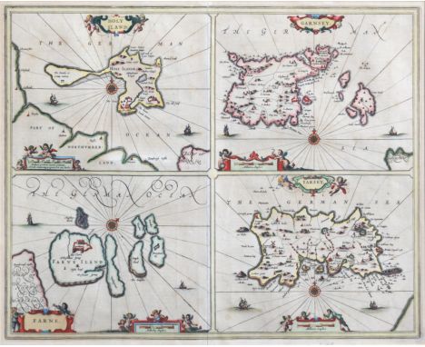
Lot 203
Robert Mordan (fl.1668-1703) - The Smaller Islands in the British Ocean, depicting Farne Island, Holy Island, Isle of Man, Scilly Islands, Jersey, Garnsey and Alderney, sold by Abel Swale, Awnsham and John Churchill, hand coloured engraving with decorative title cartouche, early 18th century, 14½ x 17in. (36.8 x 43.2cm.)., * Provenance: with The Map House, Knightsbridge, London

Lot 687
A George III silkwork map of England and Wales by Mary Ann Thompson, oval, worked in coloured silks and including parts of Scotland, Ireland and France and the Isle of Man, inscribed 'Mary Ann Thompson Nov 27th 1784' within a floral wreath upper right, within a floral meander border, 19½ x 17in. (49.5 x 43.2cm.), in a 19th century gilt and composition bead and reel moulded frame., *Condition:Coloured silks retain good colour. The linen ground is time stained throughout and has a few small insect holes (including one a little larger - 4 x 4mm. - to upper right border and one - 3 x2mm. - to Oxfordshire) and more extensive damage to the lower centre border, with some losses to the black edge thread here. Also a small loss to black edge thread to centre left. Three old splits and minor losses to frame.


Lot 201
Pertwee (Roland) Little Doggerels, illustrated by Eileen Soper, first printed 1938 together with poetry books, Meccano magazines, pamphlets, railway tickets, ration books, photographs, advertising ephemera, postcards, road map of India, Alhambra theatre programme, Mother Storks Baby Book, Pictorial plan of London, Illustrated London News cuttings, The Sphere cuttings, Punch, sheet music etc


Lot 4207
Speed, John (1552-1629). 17th-century map of Warwickshire, 'The Counti of Warwick, The Shire Town and Citie of Coventre described', hand-coloured copper engraving on laid/chain-lined paper, featuring heraldic shields, bear & ragged staff, and inset views of Warwick and Coventry. Sudbury & Humble, Latin text to verso (early edition). Framed & glazed to recto and verso. 39cm by 52cm


Lot 4212
Collection of framed antique maps of Warwickshire, 17th to 19th century, comprising: Greenwood & Co., 1830, with inset etched topographical view of Warwick Castle, 58.5cm by 69cm; Richard Blome, c.1673, 32cm by 27cm; Herman Moll, c.1730, 31.5cm by 20cm; Emanuel Bowen for General Magazine Arts & Sciences, 1760, 19.5cm by 18cm; Robert Morden (miniature), c.1720, 21cm by 16.5cm; Thomas Moule, c.1840, 26cm by 20.5cm; Isaac Slater (re-issue of James Pigot), c.1850, 36.5cm by 23cm, and an anonymous 19th-century map of Warwickshire (8)

Lot 4223
Speed, John (1552-1629). 17th-century map of Nottinghamshire, hand-coloured copper engraving on laid/chain-lined paper, featuring heraldic shields and inset view of Nottingham, published by Sudbury & Humble, English text to verso. Framed & glazed to recto and verso (both sides visible). 38.5cm by 51cm

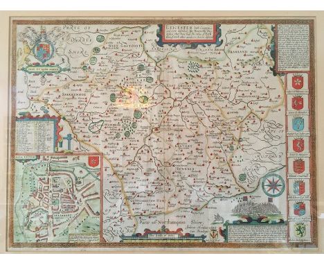
Lot 4225
Speed, John (1552-1629). 17th-century map of Leicestershire, hand-coloured copper engraving on laid/chain-lined paper, featuring heraldic shields and inset view of Leicester. Bassett & Chiswell. Mounted & framed. 39cm x 51cm. Some light creasing and pale spotting, unexamined out of frame. Attached to the verso of frame is the Leicestershire entry from England Displayed
Lot 4248
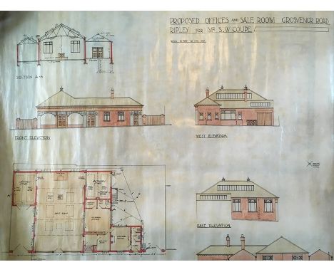
A large collection of maps and plans relating to the county of Derbyshire, predominantly linen-backed OS maps from 1880s-1950s but including several manuscript documents: 'Explanatory Plan' to accompany Mr Coke's Report showing the several Springs and Watersheds proposed to be impounded for a Supply of Water to Alfreton, Somercotes, Riddings, Swanwick and Ripley. June 1871' (ink & watercolour); a late-18th/early-19th century manuscript map on vellum showing 'Mr Rolleston's Land' and 'Newlands Farm'; a vellum indenture for land in South Normanton, dated 1873, relating to 'John Slater Wilkinson of Hilcote Hall in Blackwell in the County of Derby' and 'Raymond Wilson Radford of Sherwood House, Sutton in Ashfield in the County of Nottingham'; 'Plan of the Lordship of the Riddings in the County of Derby Belonging to Christopher Rolleston Esquire, copied from a plan made by James Green in the Year 1806 by J. Horsley 1830'; ink & watercolour architectural plan for 'Proposed Offices and Sale Room Grosvenor Road Ripley for Mr S. W. Coupe' (indistinctly signed and dated 1923). Condition varied, rolled, some discoloured/torn as found
![Ortelius, Abraham (1527-1598), Angliae, map of England and Wales [1573 or later], hand-coloured copper engraving on laid/chai](https://cdn.globalauctionplatform.com/7ba6604f-ec34-455b-8692-aa180126680e/771fefc9-7881-4c30-8efa-aa24010768cd/468x382.jpg)
Lot 4251
Ortelius, Abraham (1527-1598), Angliae, map of England and Wales [1573 or later], hand-coloured copper engraving on laid/chain-lined paper bearing manufacturer's watermark (crossed arrows), featuring decorative cartouche with birds and figures, animals, ships and sea monsters. Latin text verso (Anglia), unmounted/unframed, wide margins, good and bright, slight discolouration at upper fold-line, approx. 47cm by 57cm (sheet)

Lot 4254
Jansson, Jan (1588-1664). 17th-century map of Staffordshire, uncoloured copper engraving on heavy laid/chain-lined paper, featuring decorative cartouche, heraldic shields and figures, French text to verso, unmounted/unframed. 50.5cm by 60cm (sheet). Good, clean and bright, some very minor spotting to margins

Lot 4255
Speed, John (1552-1629). 17th-century map of Denbighshire (north-east Wales), hand-coloured copper engraving on laid/chain-lined paper, featuring decorative cartouches and inset view of Denbigh, ships and sea monsters, published by Sudbury & Humble, English text to verso. Hand-coloured recto and verso. Unmounted/unframed, 41cm x 54cm (sheet)
![Anonymous [William Smith] 17th-century map of Staffordshire, uncoloured copper engraving on laid/chain-lined paper, scarce, S](https://cdn.globalauctionplatform.com/7ba6604f-ec34-455b-8692-aa180126680e/8045554e-fc5b-416c-a0a1-aa24010808c6/468x382.jpg)

Lot 4259
Ogilby, John (1600-1676), 17th-century road map depicting the route from Buckingham to Bridgnorth, showing Banbury, Stratford-upon-Avon, Coughton, Bromsgrove, Kidderminster, Banbury, Bridgnorth and Shipston-on-Stour. Hand-coloured copper engraving on laid/chain-lined paper bearing manufacturer's watermark. Good, clean and bright, extreme left edge of margin partially trimmed (well clear of plate-mark), 40.5cm by 52cm (sheet); hinge-mounted (not stuck down), hinged along top of sheet well clear of plate-mark
Lot 4262
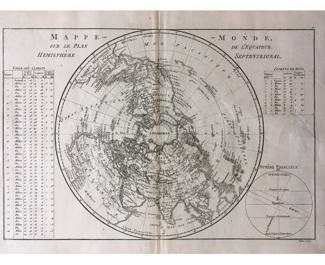
Collection of antique maps, comprising: Mappe Monde, map of the northern hemisphere, by Rigobert Bonne (1727-1794), copper engraving on laid/chain-lined paper bearing manufacturer's watermark (heart and initials 'RB'); 19th-century street plan of Birmingham engraved by J. Henshall; six 19th-century county maps engraved by S. Hall (Isle of Wight, Huntingdonshire, Cumberland, Rutlandshire, Norfolk, Westmoreland); two 19th-century street plans of Oxford and Cambridge; two 19th-century maps of Surrey and Middlesex engraved by R. Scott; 19th-century map of Shropshire for The British Gazetteer; a coaching road map showing Shropshire, Laurie & Whittle, 1806; two c.1820s engraved maps of Norfolk and Cumberland with etched inset topographical views; an etched bookplate/frontispiece topographical view of Ingestrie; four 19th-century engraved maps by J. & C. Walker, Ancient France, Ancient Italy, and two of Ancient Britain (England/Wales, Scotland); five facsimile maps after Hondius; many of the maps are mounted or in protective wallets, all housed in clip folder


Lot 4264
A New Map of Rutlandshire, Divided into Hundreds, Exhibiting its Roads, Rivers, Parks, &c., by John Cary, 1801, hand-coloured copper engraving on heavy wove paper bearing manufacturer's watermark ('Smith 1801'), unmounted/unframed, 55.5cm by 63.5cm (sheet). Together with a Robert Morden map of Rutland, uncoloured coper engraving on laid/chain-lined paper, unmounted/unframed, 39cm by 42.5cm (sheet) (2)

Lot 4266
Collection of three framed antique maps of Staffordshire: Staffordiae, Saxton & Kip, c.1637, hand-coloured copper engraving on laid/chain-lined paper, 28.5cm by 39cm; Stafford-Shyre, Michael Drayton, engraved by William Hole for Poly-Olbion, an unusual map with allegorical figures, uncoloured copper engraving on laid paper, 36.5cm by 33cm; The County of Stafford, by W. Yates, published by W. Faden, 1798, sectional map in sixteen parts, 73cm by 51cm (3)

Lot 4267
Collection of framed antique maps, 18th & 19th century, comprising: six canal plans/maps by Stockdale, 1795, hand-coloured engravings (Lancaster Canal; Canal from Liverpool to Leeds; Canal from Manchester to Runcorn; Ellesmere Canal; Rochdale Canal; Canal from the Trent to the Mersey); A Plan of the Navigable Canal from Birmingham to Atherley, Snape & Saunders; A Map of the Intended Canal to join the Rivers Severn and Trent, T. Kitchin; anonymous map showing Proposed Deviation of the Leeds and Liverpool Canal; A Plan of the Intended Navigable Canal from Leeds to Selby, Gentleman's Magazine, 1774 (unframed).Together with two 19th-century maps of Norwich (one unframed), an 18th-century map of Norfolk by Cowley, a map of Norfolk by Toms, 1742, two 19th-century maps of Walsall, a facsimile Robert Morden map of Staffordshire and a facsimile Blaeu world map (16)

![Very scarce map/prospect of Nottinghamshire with rural figures in foreground, George Bickham [1796], engraving on laid/chain-](https://cdn.globalauctionplatform.com/7ba6604f-ec34-455b-8692-aa180126680e/39c4f2aa-57eb-4e54-a6ca-aa2401085f8f/468x382.jpg)
Lot 4271
Very scarce map/prospect of Nottinghamshire with rural figures in foreground, George Bickham [1796], engraving on laid/chain-lined paper, later hand-colouring, mounted/unframed, 23cm by 16cm. Together with a rare map of Nottinghamshire by Jacob van Langeren [c.1657], and a mid-18th century map of Nottinghamshire by Herman Moll (3)

Lot 4273
Saxton, Christopher (1540-1610). Map of Lincolnshire & Nottinghamshire, 1576, featuring decorative cartouche and coastal illustrations of ships and sea monsters. Hand-coloured copper engraving on laid/chain-lined paper, 40.5cm by 53.5cm. Together with a Gerard Mercator map depicting Yorkshire, Lincolnshire, Derbyshire, Staffordshire, Nottinghamshire, Leicestershire, Rutland and Norfolk, again with sailing vessels and monsters, 37cm by 43cm. Both unframed, mounted with printseller's protective wrappers (2)


Lot 4416
Josephus, Flavius. The Genuine Works of Flavius Josephus, The Jewish Historian, by William Whiston, in four volumes, London: D. Browne, 1755. Full contemporary calf with oxblood morocco title labels, large folding map of Palestine, plus a further five folding plates/maps, armorial bookplates for Henry & Anne Rebecca Collins. Contents good and bright, bindings solid with some wear to headcaps/spines/corners (4)Four volumes by "Flavius Josephus of the Antiquities of the Jews" 1755 (complete) maps, and printed items


Lot 4514
Travel / Exploration Interest. Bell, James Stanislaus. Journal of a Residence in Circassia During the Years 1837, 1838 and 1839, first edition, in two volumes, London: Edward Moxon, 1840. Complete with all 13 plates as called for: 12 lithographs (three of which hand-coloured), folding engraved map of Circassia (in good order). Contents generally good, clean and bright, occasional pale spotting/foxing (tissue-guard of Vol.II frontis.). Rebound/rebacked but completely retaining the original publisher's embossed brown cloth with gilt titles (2)
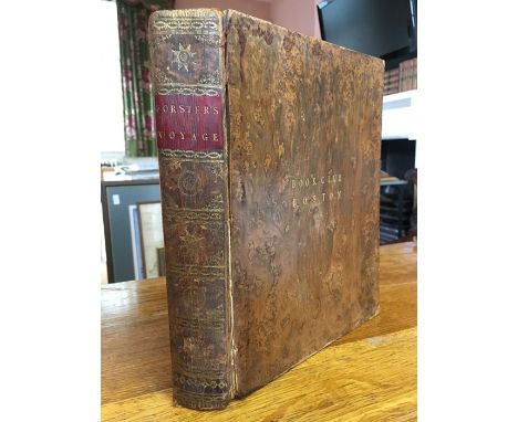
Lot 4526
Travel / Exploration Interest. Forster, John Reinold. Observations Made During a Voyage Round the World, on Physical Geography, Natural History, and Ethic Philosophy, London: G. Robinson, first edition, 1778. Quarto, full marbled calf with 'Book Club Boston' in gilt to upper board, red morocco title label, errata and list of subscribers at rear. Folding table present, lacking folding chart/map. Contents generally good, clean and bright, some discolouration/spotting to opening leaves, contemporary owner inscription to front free endpaper, 'Samuel R Fydell', remnants of old label to front pastedown
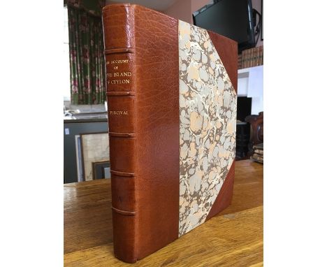
Lot 4528
Travel / Exploration Interest. Percival, Robert. An Account of The Island of Ceylon, containing Its History, Geography, Natural History, with the Manners and Customs of its various Inhabitants; to which is added, The Journal of an Embassy to the Court of Candy, first edition, London: C. and R. Baldwin, 1803. Quarto, handsome later half crushed morocco with marbled boards, gitl title, raised bands, untrimmed page edges, engraved folding map frontispiece (with a few reinforcements) plus three folding charts within the text

Lot 4530
Travel / Exploration Interest. Boswell, James. An Account of Corsica, the Journal of a Tour to that Island; and Memoirs of Pascal Paoli, first edition, Glasgow: Printed by Robert and Andrew Foulis for Edward and Charles Dilly, 1768. Engraved folding frontispiece, 'A New and Accurate Map of the Island of Corsica'. Full contemporary calf with red morocco title label, gilt title, raised bands. Attractive binding in very good order, tight and solid; contents generally very good, clean and bright throughout, some discolouration and pale spotting to a few leaves.


Lot 214
C. S. Lewis, The Chronicles of Narnia, The Magician’s Nephew, The Lion, the Witch and the Wardrobe, Prince Caspian, The Voyage of the Dawn Treader, The Silver Chair, The Horse and the Boy, The Last Battle (London, Folio Society, 1996), illustrated by Pauline Baynes. Green cloth with gold spines in gold, slipcase illustrated with the map of Narnia.

Lot 230
Richard Burton, A Secret Pilgrimage to Mecca and Medina (London, Folio Society, 2004). Introduction Tim Mackintosh-Smith. Fawn illustrated boards. Complete with 2 maps. Black slipcase. Fine. Plus, Richard Burton, The Source of the Nile (London, Folio Society, 1993). Introduction Ian Curteis. Brown pictorial boards. Complete with map. Black slipcase.
-
109198 item(s)/page