We found 109182 price guide item(s) matching your search
There are 109182 lots that match your search criteria. Subscribe now to get instant access to the full price guide service.
Click here to subscribe- List
- Grid
-
109182 item(s)/page


Lot 8740
John Haywood (British fl.1781-1792) and Edward Sudlow (British fl.1784-1793): 'Map of Worcestershire' 'Herefordshire' and 'Leicester & Rutland', three 18th century engraved maps two with hand-colouring pub. John Harrison 'Maps Of The English Counties' 1788-1789, 35cm x 44cm; Henry Beighton (British 1687-1743): 'Map of Kineton-Hundred', 18th century engraved map with hand-colouring pub. 'The antiquities of Warwickshire illustrated' c1730, 36cm x 34cm (4)

Lot 8751
Collection of 18th and 19th century engraved maps of Wiltshire, Gloucester, Essex and Shropshire including John Smeaton (British 1724-1792): 'A General Plan of the Bay and of the old and new Harbours of Rye', very rare 18th century engraved map with hand-colouring pub. 1763; and others by Charles Smith, Thomas Badeslade, Thomas Osborne, Thomas Moule, John Cary, John Emslie, Robert Dawson etc. (14)


Lot 8725
William Hole (British ?-1624) and Christopher Saxton (British c1540-c 1610): 'Frugiferi ac ameni Herefordiae comitatus qui olim pars suit Silurum delineatio' (Herefordshire), 17th century engraved map pub. William Camden 'Britannia' c1637, 29cm x 31cm (2) (unframed)Condition Report:Two copies

Lot 8712
Thomas Conder (British 1747-1831): 'Durham', 18th century engraved map with hand colouring pub. Alex Hogg c1784, 18cm x 22cm; Thomas Kitchin (British 1719-1784): ' A New Map of Durham', 18th century engraved map with hand colouring pub. c1764; Thomas Moule (British 1784-1851): 'Durham', 19th century engraved map with hand-colouring pub. c1840, 21cm x 27cm (3)


Lot 8705
John Cary (British 1754-1835): 'North Riding of Yorkshire' 'North Plan of the West Riding' South Part of the West Riding' and 'East Riding', set four 18th century engraved maps of Yorkshire with hand-colouring pub. c1793; George Kemp (British fl.1823-1843): 'East Riding and Ainsty of Yorkshire', 19th century engraved map with hand-colouring; Thomas Moule (British 1784-1851): 'Yorkshire North Riding' and 'East Riding', pair 19th century engraved maps max 23cm x 30cm (7) (unframed)


Lot 8750
John Speed (British 1552-1629): 'Suffolke Described and Divided into Hundreds, The Situation of the fayre towne Ipswich shewed, with the Armes of the most noble families that have bene either Dukes or Earles both of that Countie as also of Clare', 17th century engraved map of Suffolk with hand-colouring pub. George Huble [Humble] c1612-1624, 39cm x 51cm


Lot 8726
William Hole (British ?-1624) and Christopher Saxton (British c1540-c 1610): 'Frugiferi ac ameni Herefordiae comitatus qui olim pars suit Silurum delineatio' (Herefordshire), 17th century engraved map pub. William Camden 'Britannia' c1637, 29cm x 31cm (2) (unframed)Condition Report:Two copies


Lot 8732
Richard Blome (British 1635-1705): 'A Mapp of Ye County of Hereford with its Hundreds', 17th century engraved map pub c1673, 19cm x 24cm; Thomas Badeslade (British c1715-1750): 'Nottinghamshire' and 'Worcestershire', pair 18th century engraved maps pub. c1741, 16cm x 18cm; together with another similar, a rare map of Worcester by I Cowley and a rare map of Leicester (6)


Lot 8824
Macaulay, Z - 'Macaulay's Railway Map of England Shewing the Limits of certain L.&N.W. and G.W. Agreements', folding map of forty two panels, circa 1880 published by Smith & Ebbs, Tower Hill, London in leather boards. Contains official hand written notes and drawn lines relating to the 1863 agreement, dated 1907 138cm x 90cm

Lot 8785
Thomas Bowen (Welsh 1733-1790): 'A New and Correct Map of Great Britain from the most accurate surveys', rare 18th century engraved map with hand colouring; together with a collection of others including: John Bayly's map of 'Gloucestershire' 1779; 'Large Scale Railway & Station Map of England & Wales' 1875; 'Stanford's Map of the Environs of Paris' 1870; and a 19th century map of 'Texas and Indian Territory' (8) (unframed)


Lot 8708
Thomas T Clerk (British 18th-19th century): 'Atlantic Islands' - Cape Verde, Canary, Azore and Madeira Islands, early 19th century engraved map with hand-colouring pub. 1817; Robert K Dawson (British 1798-1861): 'Yorkshire', 19th century engraved map, with another similar; Mostyn John Armstrong (British fl.1769-1791): 'County of Berwick', 18th century engraved strip-map with hand-colouring pub. c1776; together with collection landscape engravings and a lithographed map of Glasgow max 53cm x 61cm (15)


Lot 8851
Large collection of engravings and maps to include: 'Battle of Crecy', 'Canute the Great', 'Aries' artillery war machine', various British landscape engravings and etchings, selection of mid-19th century plates from 'The Illustrated London News', map of 'England and its Railways' and others (approx. 50)


Lot 1618
2 Seidentücher der Serie "Carré" in Original-Kartons. Hermés Paris. Tücher 85 x 88 cm, Karton 24 x 24 cm. Annähernd quadratische Tücher. Bandelwerk-Ornament aus Reiterzubehör "eperon d'or" beschriftet bzw. Australienkarte mit Schiffen und Persönlichkeiten in der Ornamentrahmung. Je gemarkter oranger Karton mit eingesteckter Broschüre zur Serie Carré. Aufrufzeit 26. | Okt 2023 | voraussichtlich 15:32 Uhr (CET)2 silk scarves of the series "Carré" in original boxes. Hermés Paris. Sheets 85 x 88 cm, cardboard 24 x 24 cm.Approximately square cloths. Bandelwerk ornament of equestrian accessories "eperon d'or" inscribed or Australia map with ships and personalities in the ornament frame. Each marked orange box with inserted brochure to the series Carré. Call time 26 | Oct 2023 | expected 15:32 (CET).*This is an automatically generated translation from German by deepl.com and only to be seen as an aid - not a legally binding declaration of lot properties. Please note that we can only guarantee for the correctness of description and condition as provided by the German description.
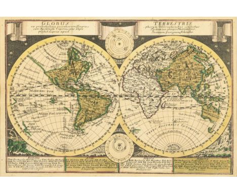
Lot 1750
SCHREIBER, Johann Georg(1676 Spremberg - 1750 Leipzig) WeltkarteKolorierter Kupferstich. Druckplatte: 17 x 24,5 cm. Gerahmt & hinter Glas : 27 x 33 cm. Detaillierte Weltkarte mit zwei Hemisphären, Titelband "Globus Terrestris ex Probatissimis Recentiorum Geographorum Observationibus […]", Legende zu "Europa", "Asia", "Africa" und "America", umgeben von Naturphänomen; zwei weitere Darstellungen mit Kopernikanischem und Tychonischem Weltbild; aus "Atlas Selectus von allen Königreichen und Ländern der Welt, Zum bequemen Gebrauch in Schulen, auf Reisen und bey dem Lesen der Zeitungen", Leipzig, 1730. Bugfalte, Blatt lichtgebräunt. Deutscher Kupferstecher, Kartograf und Verleger. Aufrufzeit 26. | Okt 2023 | voraussichtlich 16:45 Uhr (CET) SCHREIBER, Johann Georg(1676 Spremberg - 1750 Leipzig) World mapColored copper engraving. Printing plate: 17 x 24.5 cm. Framed & behind glass : 27 x 33 cm. Detailed world map with two hemispheres, title band "Globus Terrestris ex Probatissimis Recentiorum Geographorum Observationibus [...]", legend to "Europe", "Asia", "Africa" and "America", surrounded by natural phenomena; two other representations with Copernican and Tychonian world view; from "Atlas Selectus of all kingdoms and countries of the world, For convenient use in schools, on trips and bey dem Lesen der Zeitungen", Leipzig, 1730. Buck crease, sheet light browned. German engraver, cartographer and publisher. Call time 26th | Oct 2023 | expected 16:45 (CET).*This is an automatically generated translation from German by deepl.com and only to be seen as an aid - not a legally binding declaration of lot properties. Please note that we can only guarantee for the correctness of description and condition as provided by the German description.
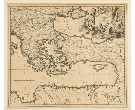
Lot 1751
DANCKERTS, Justus(1635 Amsterdam - 1701 Amsterdam) Landkarte des MittelmeerraumesKupferstich. Blatt: 51,5 x 59 cm, auf Karton montiert 56 x 64,5 cm. Detaillierte Landkarte des Mittelmeerraumes, große figürliche Titelkartusche "Accuratissima orientalioris districtus maris Mediterranei tabula", Meilenzeiger. Bugfalte, Blatt griff- und knickspurig, etwas stockfleckig. Aus der niederländischen Kupferstecher- und Verlegerfamilie Danckerts, die zu den bekanntesten niederländischen Herausgebern für Landkarten und Atlanten gehören. Aufrufzeit 26. | Okt 2023 | voraussichtlich 16:45 Uhr (CET) DANCKERTS, Justus(1635 Amsterdam - 1701 Amsterdam) Map of the MediterraneanCopper engraving. Sheet: 51.5 x 59 cm, mounted on cardboard 56 x 64.5 cm. Detailed map of the Mediterranean, large figural title cartouche "Accuratissima orientalioris districtus maris Mediterranei tabula", mileage pointer. crease, sheet grip and crease, some foxing. From the Dutch family of engravers and publishers Danckerts, who are among the most famous Dutch publishers of maps and atlases. Call time 26 | Oct 2023 | expected 16:45 (CET).*This is an automatically generated translation from German by deepl.com and only to be seen as an aid - not a legally binding declaration of lot properties. Please note that we can only guarantee for the correctness of description and condition as provided by the German description.
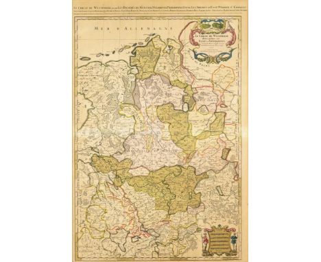
Lot 1752
SANSON, Nicolas(1600 Abbeville - 1667 Paris) Große Landkarte des Westfälischen ReichskreisesWohl Nachdruck des 19. Jh. Druckplatte: 88 x 59 cm. Gerahmt & hinter Glas : 104,5 x 75 cm. Große, detaillierte Karte des Westfälischen Reichskreises, Titelkartusche mit Beschlagwerk und Jagdmotiven "Le Cercle de Westphalie divisé en tous ses Estats et Souverainetés. Dressé sur les Memoires les plus nouveaux Parle Sr. Sanson, Geographe Ordinaire du Roy A Paris chez H. Jaillot [...]", Beikartusche mit Meilenzeigern; 1692 unter Alexis Hubert Jaillot (1632 - 1712) herausgegeben. Bugfalte, Blatt stärker lichtgebräunt und stockfleckig. Französischer Kartograf; gilt als Vater der Geografie in Frankreich und wurde zum königlichen Kartenmacher ernannt - er unterrichtete die französischen Könige Ludwig XIII. und Ludwig XIV. in Geografie. Aufrufzeit 26. | Okt 2023 | voraussichtlich 16:46 Uhr (CET) SANSON, Nicolas(1600 Abbeville - 1667 Paris) Large map of the Westphalian Imperial CircleProbably 19th century reprint Printing plate: 88 x 59 cm. Framed & behind glass : 104.5 x 75 cm. Large, detailed map of the Westphalian Imperial Circle, title cartouche with hardware and hunting motifs "Le Cercle de Westphalie divisé en tous ses Estats et Souverainetés. Dressé sur les Memoires les plus nouveaux Parle Sr. Sanson, Geographe Ordinaire du Roy A Paris chez H. Jaillot [...]", accompanying cartouche with mileage markers; published in 1692 under Alexis Hubert Jaillot (1632 - 1712). Buck crease, leaf more light browned and foxing. French cartographer; considered the father of geography in France and was appointed royal mapmaker - he taught geography to the French kings Louis XIII and Louis XIV. Call time 26 | Oct 2023 | expected 16:46 (CET)*This is an automatically generated translation from German by deepl.com and only to be seen as an aid - not a legally binding declaration of lot properties. Please note that we can only guarantee for the correctness of description and condition as provided by the German description.

Lot 1753
SANSON, Guillaume(verstorben 1703) Landkarte der griechischen Inseln "Graecia Foederata"Kolorierter Kupferstich. Druckplatte: 42 x 51,5 cm, Blatt: 46 x 61,5 cm. Detaillierte Landkarte von Griechenland und der zugehörigen Inseln, mit schmuckvoller Titelkartusche "Graecia Foederata sub, Agamemnone ob Helenae Raptum in Troiam Coniurans ex Homero Collecta Conatibus Geographicis", aus "Cartes Generales de toutes les parties du Monde", 1657. Hinterklebte Bugfalte, Randbereich griffspurig und gebräunt. Sohn des Nicolas Sanson, der als Vater der Geografie in Frankreich gilt und die französischen Könige Ludwig XIII. und Ludwig XIV. in Geografie unterrichtete. Aufrufzeit 26. | Okt 2023 | voraussichtlich 16:46 Uhr (CET) SANSON, Guillaume(died 1703) Map of the Greek Islands "Graecia Foederata"Colored copperplate engraving. Printing plate: 42 x 51.5 cm, sheet: 46 x 61.5 cm. Detailed map of Greece and the associated islands, with ornate title cartouche "Graecia Foederata sub, Agamemnone ob Helenae Raptum in Troiam Coniurans ex Homero Collecta Conatibus Geographicis", from "Cartes Generales de toutes les parties du Monde", 1657. Backglued centerfold, marginal traces of grip and browned. Son of Nicolas Sanson, considered the father of geography in France and taught geography to the French kings Louis XIII and Louis XIV. Call time 26 | Oct 2023 | expected 16:46 (CET)*This is an automatically generated translation from German by deepl.com and only to be seen as an aid - not a legally binding declaration of lot properties. Please note that we can only guarantee for the correctness of description and condition as provided by the German description.

Lot 1754
SANSON, (1600 Abbeville - 1667 Paris) Landkarte der Halbinsel PeloponnesKolorierter Kupferstich. Druckplatte: 48 x 54,5 cm, Blatt: 56 x 63 cm. Detaillierte Landkarte der griechischen Halbinsel Peloponnes, mit schmückender Titelkartuscher "Peloponnesi hodie Morea", figürlicher Kartusche mit Meilenzeigern. Randbereich rissig und knickspurig, Bugfalte mit Rissen, etwas fleckig. Französischer Kartograf; gilt als Vater der Geografie in Frankreich und wurde zum königlichen Kartenmacher ernannt - er unterrichtete die französischen Könige Ludwig XIII. und Ludwig XIV. in Geografie. Aufrufzeit 26. | Okt 2023 | voraussichtlich 16:47 Uhr (CET) SANSON, (1600 Abbeville - 1667 Paris) Map of the Peloponnese PeninsulaColored copperplate engraving. Printing plate: 48 x 54.5 cm, sheet: 56 x 63 cm. Detailed map of the Greek peninsula of Peloponnese, with decorative title cartouche "Peloponnesi hodie Morea", figural cartouche with mileage pointers. Margin cracked and creased, centerfold with tears, some staining. French cartographer; considered the father of geography in France and was appointed royal mapmaker - he taught geography to the French kings Louis XIII and Louis XIV. Call time 26 | Oct 2023 | expected 16:47 (CET)*This is an automatically generated translation from German by deepl.com and only to be seen as an aid - not a legally binding declaration of lot properties. Please note that we can only guarantee for the correctness of description and condition as provided by the German description.
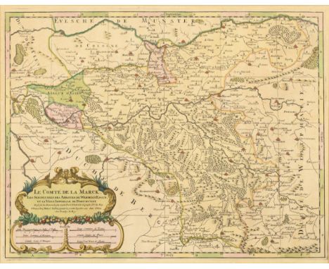
Lot 1755
SANSON, Nicolas(1600 Abbeville - 1667 Paris) Landkarte der Grafschaft MarkWohl Nachdruck des 19. Jh. Druckplatte: 43,5 x 56 cm. Gerahmt & hinter Glas : 62 x 74 cm. Detaillierte Landkarte der Grafschaft Mark mit der Abtei Essen und der Abtei Wehrden, ornamentale Titelkartusche "Le Comté de La Marck, Les Seigneuries des Abbayes de Werden, D'Essen, et de la Ville Imperiale de Dortmundt", Beikartusche mit Meilenzeigern; 1696 unter Alexis Hubert Jaillot (1632 - 1712) herausgegeben. Blatt stärker lichtgebräunt. Französischer Kartograf; gilt als Vater der Geografie in Frankreich und wurde zum königlichen Kartenmacher ernannt - er unterrichtete die französischen Könige Ludwig XIII. und Ludwig XIV. in Geografie. Aufrufzeit 26. | Okt 2023 | voraussichtlich 16:47 Uhr (CET) SANSON, Nicolas(1600 Abbeville - 1667 Paris) Map of the County of MarkProbably 19th century reprint Printing plate: 43.5 x 56 cm. Framed & behind glass : 62 x 74 cm. Detailed map of the County of Mark with the Abbey of Essen and the Abbey of Wehrden, ornamental title cartouche "Le Comté de La Marck, Les Seigneuries des Abbayes de Werden, D'Essen, et de la Ville Imperiale de Dortmundt", supplementary cartouche with mileage markers; published in 1696 under Alexis Hubert Jaillot (1632 - 1712). Sheet more light browned. French cartographer; considered the father of geography in France and was appointed royal mapmaker - he taught geography to the French kings Louis XIII and Louis XIV. Call time 26 | Oct 2023 | expected 16:47 (CET)*This is an automatically generated translation from German by deepl.com and only to be seen as an aid - not a legally binding declaration of lot properties. Please note that we can only guarantee for the correctness of description and condition as provided by the German description.

Lot 1756
JANSSONIUS, Johannes(1588 Arnhem - 1664 Amsterdam) Landkarte von ThessalienKolorierter Kupferstich. 53,5 x 62,7 cm. Detaillierte Landkarte der nordgriechischen Region Thessalien, mit figürlicher Titelkartusche "Thessaliae", Rollwerkkartusche mit Meilenzeigern, dekoriert mit Seemonster und Segelschiffen, nach einer Karte von I. Laurenbergio. Auf Büttenpapier montiert, Blatt griff- und knickspurig. Niederländischer Kartograf, Verleger und Hersteller von Globen. Er führte die Herausgabe der Mercator-Hondius-Atlanten fort. Aufrufzeit 26. | Okt 2023 | voraussichtlich 16:48 Uhr (CET) JANSSONIUS, Johannes(1588 Arnhem - 1664 Amsterdam) Map of ThessalyColored copper engraving. 53.5 x 62.7 cm. Detailed map of the northern Greek region of Thessaly, with figural title cartouche "Thessaliae", scrollwork cartouche with mile markers, decorated with sea monsters and sailing ships, after a map by I. Laurenbergio. Mounted on laid paper, sheet with traces of handling and creases. Dutch cartographer, publisher and manufacturer of globes. He continued the publication of the Mercator-Hondius atlases. Call time 26 | Oct 2023 | expected 16:48 (CET)*This is an automatically generated translation from German by deepl.com and only to be seen as an aid - not a legally binding declaration of lot properties. Please note that we can only guarantee for the correctness of description and condition as provided by the German description.
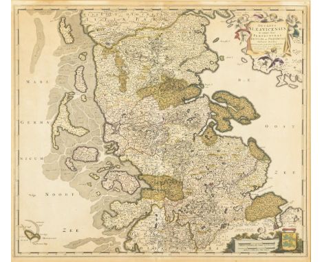
Lot 1757
WIT, Frederik de(1630 Amsterdam - 1706 Amsterdam) Landkarte des Herzogtums SchleswigWohl Nachdruck des 19. Jh. Druckplatte: 49,5 x 57,5 cm. Gerahmt & hinter Glas : 67 x 54 cm. Detaillierte Landkarte des Herzogtums Schleswig, mit figürlicher Titelkartusche "Ducatus Slesvicensis in omnes suas Praefecturas Circulos et Provincias Distinte Divisus [...]" und Meilenzeiger. Blatt stärker lichtgebräunt, Bugfalte gerissen. Niederländischer Verleger, Kupferstecher und Kartograf; das von ihm gegründete Verlagshaus wurde nacheinander von drei gleichnamigen Personen geführt. Aufrufzeit 26. | Okt 2023 | voraussichtlich 16:48 Uhr (CET) WIT, Frederik de(1630 Amsterdam - 1706 Amsterdam) Map of the Duchy of SchleswigProbably 19th century reprint Printing plate: 49.5 x 57.5 cm. Framed & behind glass : 67 x 54 cm. Detailed map of the Duchy of Schleswig, with figural title cartouche "Ducatus Slesvicensis in omnes suas Praefecturas Circulos et Provincias Distinte Divisus [...]" and mileage indicator. Sheet more light browned, centerfold torn. Dutch publisher, engraver and cartographer; the publishing house he founded was successively led by three people with the same name. Call time 26 | Oct 2023 | expected 16:48 (CET)*This is an automatically generated translation from German by deepl.com and only to be seen as an aid - not a legally binding declaration of lot properties. Please note that we can only guarantee for the correctness of description and condition as provided by the German description.
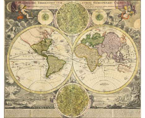
Lot 1759
HOMANN, Johann Baptist(1664 Oberkammlach - 1724 Nürnberg) Außergewöhnliche WeltkarteKolorierter Kupferstich. Gerahmt & hinter Glas : 56,7 x 65 cm. Äußerst dekorative Weltkarte der östlichen und westlichen Hemisphäre, 2 weitere Hemisphären mit dem nördlichen und südlichen Sternenhimmel mit den Sternbildern, Darstellung der Sommer- und Wintersonnenwende, Titelkartusche mit Spruchband "Planiglobii Terrestris Cum Utroq Hemisphærio Cælesti Generalis", gehalten von 2 Putten, die Tag und Nacht symbolisieren; reich dekoriert mit detaillierten Darstellungen von Göttern des Windes und Naturphänomenen, Beschreibung der Naturphänomene in lateinischer Sprache; erstmals erschienen in Johann Baptist Homanns Ältestem Atlas von 1707. Blatt griffspurig, stockfleckig. Deutscher Kartograf, Kupferstecher, Verleger und Globenhersteller; bedeutendster deutscher Herausgeber von Atlanten und Landkarten im 18. Jh. Aufrufzeit 26. | Okt 2023 | voraussichtlich 16:49 Uhr (CET) HOMANN, Johann Baptist(1664 Oberkammlach - 1724 Nuremberg) Extraordinary world mapColored copperplate engraving. Framed & behind glass : 56.7 x 65 cm. Extremely decorative world map of the eastern and western hemispheres, 2 other hemispheres with the northern and southern starry sky with the constellations, depicting the summer and winter solstice, title cartouche with banner "Planiglobii Terrestris Cum Utroq Hemisphærio Cælesti Generalis" held by 2 putti symbolizing day and night; richly decorated with detailed depictions of gods of wind and natural phenomena, description of natural phenomena in Latin; first appeared in Johann Baptist Homann's Oldest Atlas of 1707. Leaf griffspurig, foxing. German cartographer, engraver, publisher and globe maker; most important German publisher of atlases and maps in the 18th century Call time 26 | Oct 2023 | probably 16:49 (CET).*This is an automatically generated translation from German by deepl.com and only to be seen as an aid - not a legally binding declaration of lot properties. Please note that we can only guarantee for the correctness of description and condition as provided by the German description.

Lot 1760
HOMANN, Johann Baptist(1664 Oberkammlach - 1724 Nürnberg) Historische Postroutenkarte von DeutschlandKolorierter Kupferstich. Blatt: 52 x 61 cm. Detaillierte, zur damaligen Zeit bahnbrechende Landkarte des Obersten Feldpostmeisters Johann Peter Nell zu Damenacher (1672 -1743) mit Postwegen und Poststationen durch Deutschland, mit den angrenzenden Ländern, heraldische Titelkartusche "Illustrissimo ac Excellentissimo Domino Dno Carolo Josepho [...]", mit Titel in lateinischer Sprache am oberen Rand "Postarum seu Veredariorum Stationes per Germaniam et Provincias Adiacentes", Titel in deutscher Sprache unten rechts "Neu-vermehrte Post-Charte durch gantz Teutschland nach Italien, Franckreich, Niederland, Preußen, Polen und Ungarn etc.", Legende und Meilenzeigern, ca. 1720. Blatt stockfleckig, hinterklebte Bugfalte, Randbereich gebräunt und teils hinterklebt. Deutscher Kartograf, Kupferstecher, Verleger und Globenhersteller; bedeutendster deutscher Herausgeber von Atlanten und Landkarten im 18. Jh. Aufrufzeit 26. | Okt 2023 | voraussichtlich 16:50 Uhr (CET) HOMANN, Johann Baptist(1664 Oberkammlach - 1724 Nuremberg) Historical Postal Route Map of GermanyColored copperplate engraving. Sheet: 52 x 61 cm. Detailed, at the time pioneering map by the chief field postmaster Johann Peter Nell zu Damenacher (1672 -1743) showing postal routes and postal stations through Germany, with adjacent countries, heraldic title cartouche "Illustrissimo ac Excellentissimo Domino Dno Carolo Josepho [...]", with title in Latin in the upper margin "Postarum seu Veredariorum Stationes per Germaniam et Provincias Adiacentes", title in German lower right "Neu-vermehrte Post-Charte durch gantz Teutschland nach Italien, Franckreich, Niederland, Preußen, Polen und Ungarn etc.", legend and mileage markers, ca. 1720. Sheet foxed, back-taped centerfold, marginal browned and partly back-taped. German cartographer, engraver, publisher and globe maker; most important German publisher of atlases and maps in the 18th century Call time 26th | Oct 2023 | probably 16:50 (CET).*This is an automatically generated translation from German by deepl.com and only to be seen as an aid - not a legally binding declaration of lot properties. Please note that we can only guarantee for the correctness of description and condition as provided by the German description.

Lot 1762
HOMANN, Johann Baptist(1664 Oberkammlach - 1724 Nürnberg) Landkarte des Bayerischen ReichskreisesKolorierter Kupferstich. Blatt: 61x 52 cm. Detaillierte Landkarte von Niederbayern, Oberbayern und der Oberpfalz, mit heraldischer Titelkartusche "Bavariae, Circulus et Electorat [...]", mit Titel in französischer Sprache am oberen Rand, Legende und Meilenzeigern, ca. 1720. Blatt griffspurig und stockfleckig, hinterklebte Bugfalte, Randbereich gebräunt. Deutscher Kartograf, Kupferstecher, Verleger und Globenhersteller; bedeutendster deutscher Herausgeber von Atlanten und Landkarten im 18. Jh. Aufrufzeit 26. | Okt 2023 | voraussichtlich 16:51 Uhr (CET) HOMANN, Johann Baptist(1664 Oberkammlach - 1724 Nuremberg) Map of the Bavarian Imperial CountyColored copperplate engraving. Sheet: 61x 52 cm. Detailed map of Lower Bavaria, Upper Bavaria and the Upper Palatinate, with heraldic title cartouche "Bavariae, Circulus et Electorat [...]", with title in French at the top margin, legend and mileage markers, ca. 1720. Sheet grip-marked and foxed, back-taped centerfold, marginal area browned. German cartographer, engraver, publisher and globe maker; most important German publisher of atlases and maps in the 18th century Call time 26th | Oct 2023 | expected 16:51 (CET).*This is an automatically generated translation from German by deepl.com and only to be seen as an aid - not a legally binding declaration of lot properties. Please note that we can only guarantee for the correctness of description and condition as provided by the German description.
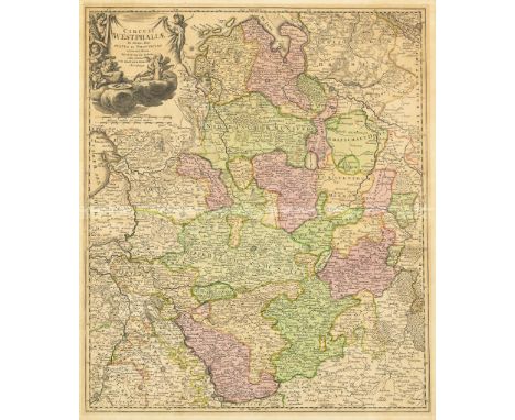
Lot 1764
HOMANN, Johann Baptist(1664 Oberkammlach - 1724 Nürnberg) Landkarte des Westfälischen ReichskreisesKolorierter Kupferstich. Gerahmt & hinter Glas : 65 x 56 cm. Detaillierte Landkarte des Westfälischen Reichskreises mit dem Gebiet zwischen Hamburg, Köln, Oldenburg und Hannover, mit figürlicher Titelkartusche "Circuli Westphaliae in Omnes suos Status et Provincias" und Meilenzeiger. Bugfalte, Abbildungsbereich stark lichtgebräunt, wohl hinterklebt. Deutscher Kartograf, Kupferstecher, Verleger und Globenhersteller; bedeutendster deutscher Herausgeber von Atlanten und Landkarten im 18. Jh.. Aufrufzeit 26. | Okt 2023 | voraussichtlich 16:52 Uhr (CET) HOMANN, Johann Baptist(1664 Oberkammlach - 1724 Nuremberg) Map of the Westphalian Imperial CircleColored copperplate engraving. Framed & behind glass : 65 x 56 cm. Detailed map of the Westphalian Imperial Circle with the area between Hamburg, Cologne, Oldenburg and Hanover, with figural title cartouche "Circuli Westphaliae in Omnes suos Status et Provincias" and mileage indicator. Bow crease, illustration area heavily light browned, probably pasted behind. German cartographer, engraver, publisher and globe maker; most important German publisher of atlases and maps in the 18th century. Call time 26 | Oct 2023 | expected 16:52 (CET)*This is an automatically generated translation from German by deepl.com and only to be seen as an aid - not a legally binding declaration of lot properties. Please note that we can only guarantee for the correctness of description and condition as provided by the German description.
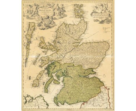
Lot 1767
HOMANN, Johann Baptist(1664 Oberkammlach - 1724 Nürnberg) Landkarte von SchottlandKolorierter Kupferstich. Gerahmt & hinter Glas : 74,5 x 67 cm. Landkarte von Schottland, dem nördlichen Teil der Insel Großbritannien, mit detailreicher figürliche Titelkartusche "Magna Brittania Pars Septentrionalis qua Regnum Scotiae" und figürliche Beikartusche mit Wappen und Meilenzeigern. Blatt stark lichtgebräunt, stockfleckig, wohl hinterklebt. Deutscher Kartograf, Kupferstecher, Verleger und Globenhersteller; bedeutendster deutscher Herausgeber von Atlanten und Landkarten im 18. Jh. Aufrufzeit 26. | Okt 2023 | voraussichtlich 16:53 Uhr (CET) HOMANN, Johann Baptist(1664 Oberkammlach - 1724 Nuremberg) Map of ScotlandColored copper engraving. Framed & behind glass : 74.5 x 67 cm. Map of Scotland, the northern part of the island of Great Britain, with detailed figural title cartouche "Magna Brittania Pars Septentrionalis qua Regnum Scotiae" and figural subsidiary cartouche with coat of arms and mile markers. Sheet heavily light browned, foxing, probably pasted behind. German cartographer, engraver, publisher and globe maker; most important German publisher of atlases and maps in the 18th century Call time 26th | Oct 2023 | probably 16:53 (CET).*This is an automatically generated translation from German by deepl.com and only to be seen as an aid - not a legally binding declaration of lot properties. Please note that we can only guarantee for the correctness of description and condition as provided by the German description.

Lot 1768
HOMANN, Johann Baptist (Erben) Landkarte von ThüringenKolorierter Kupferstich. Blatt: 52 x 61 cm. Detailreiche Landkarte der thüringischen Fürstentümer und Grafschaften, mit figürlicher Titelkartusche "Landgraviae Thuringiae tabula generalis in suos principatus [...]", oberer Rand mit Titel in lateinischer Sprache, Legende und Meilenzeigern, ca. 1729, am linken Rand mit handschriftlichen Notizen in Tusche. Blatt stockfleckig, hinterklebte Bugfalte, Randbereich gebräunt. Johann Baptist Homann (1664 - 1724), deutscher Kartograf, Kupferstecher, Verleger und Globenhersteller; bedeutendster deutscher Herausgeber von Atlanten und Landkarten im 18. Jh. Aufrufzeit 26. | Okt 2023 | voraussichtlich 16:54 Uhr (CET) HOMANN, Johann Baptist (Heirs) Map of ThuringiaColored copperplate engraving. Sheet: 52 x 61 cm. Detailed map of the Thuringian principalities and counties, with figural title cartouche "Landgraviae Thuringiae tabula generalis in suos principatus [...]", upper margin with title in Latin, legend and mile markers, ca. 1729, left margin with handwritten notes in ink. Sheet foxed, back-taped centerfold, marginal area browned. Johann Baptist Homann (1664 - 1724), German cartographer, engraver, publisher and globe maker; most important German publisher of atlases and maps in the 18th century Call time 26th | Oct 2023 | expected 16:54 (CET).*This is an automatically generated translation from German by deepl.com and only to be seen as an aid - not a legally binding declaration of lot properties. Please note that we can only guarantee for the correctness of description and condition as provided by the German description.

Lot 1770
HOMANN, Johann Baptist (Erben) Landkarte der SchweizKolorierter Kupferstich. Blatt: 52 x 61 cm. Detaillierte Landkarte der Schweiz, mit heraldischer Titelkartusche mit den 13 Wappen der 13 Kantone "Potentissimae Helvetiorum Reipublicae Cantones Tredecim [...]", Meilenzeigern und Titel in lateinischer Sprache am oberen Rand, unten links detailreiche Innenansicht einer Sennhütte, 1732. Blatt stärker griffspurig und stockfleckig, hinterklebte Bugfalte. Johann Baptist Homann (1664 - 1724), deutscher Kartograf, Kupferstecher, Verleger und Globenhersteller; bedeutendster deutscher Herausgeber von Atlanten und Landkarten. Aufrufzeit 26. | Okt 2023 | voraussichtlich 16:55 Uhr (CET) HOMANN, Johann Baptist (Heirs) Map of SwitzerlandColored copperplate engraving. Sheet: 52 x 61 cm. Detailed map of Switzerland, with heraldic title cartouche with the 13 coats of arms of the 13 cantons "Potentissimae Helvetiorum Reipublicae Cantones Tredecim [...]", mile markers and title in Latin at the top margin, bottom left detailed interior view of a sennhütte, 1732. Sheet more grip-marked and foxed, back-taped centerfold. Johann Baptist Homann (1664 - 1724), German cartographer, engraver, publisher and globe maker; most important German publisher of atlases and maps. Call time 26 | Oct 2023 | expected 16:55 (CET)*This is an automatically generated translation from German by deepl.com and only to be seen as an aid - not a legally binding declaration of lot properties. Please note that we can only guarantee for the correctness of description and condition as provided by the German description.

Lot 1771
HOMANN, Johann Baptist (Erben) Landkarte der ApenninhalbinselKolorierter Kupferstich. Blatt: 52 x 61 cm. Detaillierte Landkarte der Apenninhalbinsel mit Sizilien, Korsika und Sardinien, mit figürlicher Titelkartusche "Italia in suos Status divisa et ex prototypo del Isliano de sumsta [...]", Meilenzeigern und Titel in italienischer Sprache am oberen Rand, ca. 1742. Blatt etwas verschmutzt und stockfleckig, hinterklebte Bugfalte, unterer Rand verstärkt. Johann Baptist Homann (1664 - 1724), deutscher Kartograf, Kupferstecher, Verleger und Globenhersteller; bedeutendster deutscher Herausgeber von Atlanten und Landkarten im 18. Jh. Aufrufzeit 26. | Okt 2023 | voraussichtlich 16:55 Uhr (CET) HOMANN, Johann Baptist (Heirs) Map of the Apennine PeninsulaColored copperplate engraving. Sheet: 52 x 61 cm. Detailed map of the Apennine Peninsula with Sicily, Corsica and Sardinia, with figural title cartouche "Italia in suos Status divisa et ex prototypo del Isliano de sumsta [...]", mileage markers and title in Italian in the upper margin, ca. 1742. Sheet somewhat soiled and foxed, back-taped centerfold, lower margin reinforced. Johann Baptist Homann (1664 - 1724), German cartographer, engraver, publisher and globe maker; most important German publisher of atlases and maps in the 18th century Call time 26th | Oct 2023 | probably 16:55 (CET).*This is an automatically generated translation from German by deepl.com and only to be seen as an aid - not a legally binding declaration of lot properties. Please note that we can only guarantee for the correctness of description and condition as provided by the German description.

Lot 1772
HOMANN, Johann Baptist (Erben) Landkarte von EuropaKolorierter Kupferstich. Blatt: 52 x 61 cm. Detaillierte Landkarte von Europa, mit allegorischer Titelkartusche "Europa Secundum Legitimas Projectionis Stereographicae Regulas et Juxta Recentissimas Observationes Aeque ac Relationes [...]", Meilenzeigern und Titel in französischer Sprache am oberen Rand, mit stereografischer Horizontalprojektion nach Johann Matthias Hase (1684 - 1742), 1743. Blatt stärker griffspurig und stockfleckig, hinterklebte Bugfalte, unterer Rand verstärkt. Johann Baptist Homann (1664 - 1724), deutscher Kartograf, Kupferstecher, Verleger und Globenhersteller; bedeutendster deutscher Herausgeber von Atlanten und Landkarten. Aufrufzeit 26. | Okt 2023 | voraussichtlich 16:56 Uhr (CET) HOMANN, Johann Baptist (Heirs) Map of EuropeColored copperplate engraving. Sheet: 52 x 61 cm. Detailed map of Europe, with allegorical title cartouche "Europa Secundum Legitimas Projectionis Stereographicae Regulas et Juxta Recentissimas Observationes Aeque ac Relationes [...]", mileage markers and title in French in the upper margin, with stereographic horizontal projection after Johann Matthias Hase (1684 - 1742), 1743. Sheet more grip-marked and foxed, back-taped centerfold, lower margin reinforced. Johann Baptist Homann (1664 - 1724), German cartographer, engraver, publisher and globe maker; most important German publisher of atlases and maps. Call time 26 | Oct 2023 | expected 16:56 (CET)*This is an automatically generated translation from German by deepl.com and only to be seen as an aid - not a legally binding declaration of lot properties. Please note that we can only guarantee for the correctness of description and condition as provided by the German description.

Lot 1773
WALCH, Johann(1757 Kempten - 1815 Augsburg) Landkarte des Osmanischen ReichesKolorierter Kupferstich. Druckplatte: 51,5 x 60,5 cm, Blatt: 55 x 67 cm. Detaillierte Landkarte des europäischen Teils des osmanischen Reiches, mit Titelkartusche "Imperii Osmanici sive Turcici Europaei tabula ad normam Recentissimarum Observationem concinnata Sumtibus joannis Walchii, Augustae Vind. - Das osmanische Reich in Europa. Nach den neuesten nachrichten und bewährtesten Hülfsmitteln [...] 1820 entworfen" . Hinterklebte Bugfalten, großer Knick im rechten Bereich, etwas griffspurig und stockfleckig. Deutscher Maler, Zeichner, Kupferstecher, Kartograph und Verleger. Aufrufzeit 26. | Okt 2023 | voraussichtlich 16:56 Uhr (CET) WALCH, Johann(1757 Kempten - 1815 Augsburg) Map of the Ottoman EmpireColor copperplate. Printing plate: 51.5 x 60.5 cm, sheet: 55 x 67 cm. Detailed map of the European part of the Ottoman Empire, with title cartouche "Imperii Osmanici sive Turcici Europaei tabula ad normam Recentissimarum Observationem concinnata Sumtibus joannis Walchii, Augustae Vind. - The Ottoman Empire in Europe. According to the latest news and proven Hülfsmitteln [...] 1820 designed" . Backglued centerfolds, large crease in the right area, some grip and foxing. German painter, draftsman, engraver, cartographer and publisher. Call time 26 | Oct 2023 | expected 16:56 (CET).*This is an automatically generated translation from German by deepl.com and only to be seen as an aid - not a legally binding declaration of lot properties. Please note that we can only guarantee for the correctness of description and condition as provided by the German description.
-
109182 item(s)/page