We found 108737 price guide item(s) matching your search
There are 108737 lots that match your search criteria. Subscribe now to get instant access to the full price guide service.
Click here to subscribe- List
- Grid
-
108737 item(s)/page


Lot 120
Greece.- Wordsworth (Christopher) Greece: Pictorial, Descriptive, and Historical, new edition, engraved frontispiece, additional vignette title, steel engraved map, plates, illustrations, occasional faint spotting, cracked hinges, contemporary morocco, gilt, a little rubbed, 1853 § Brayley (E. W.) Views in Suffolk, Norfolk, and Northamptonshire; Illustrative of the Works of Robert Bloomfield, engraved frontispiece, additional vignette title, 12 plates, occasional spotting, bookplate, contemporary calf, rubbed joints, 1806 § Pope (Alexander) The Works of ..., engraved frontispiece, additional vignette title, plates, prize label, contemporary morocco, gilt, a little rubbed, [c.1850]; 8vo & 12mo (3)

Lot 123
Polar.- M'Clure (Capt. Robert) The Discovery of the North-West Passage by H.M.S. "Investigator" ..., edited by Commander Sherard Osborn, first edition, lithographed frontispiece, 3 plates, folding hand-coloured map, occasional faint spotting, contemporary half-calf, rebacked, 1856 § Barrow (Sir John) Voyages of Discovery and Research within the Arctic Regions, first edition, engraved portrait frontispiece, 2 maps (1 folding), occasional faint spotting, bookplate, later calf, gilt, 1846; 8vo (2)

Lot 124
Polar.- Richardson (Sir John) Arctic Searching Expedition: a Journal of a Boat-Voyage through Rupert's Land and the Arctic Sea, 2 vol., first edition, colour lithographed frontispieces and 8 plates, 1 hand-coloured linen backed folding map, a little chipped, some marginal damp-staining, ex-Belfast Library with ink stamps, occasional pencil annotations, modern half calf, 1851 § Franklin (Sir John) Narrative of a Journey to the Shores of the Polar Sea, second edition, 2 vol., hand-coloured engraved folding map frontispiece, 3 folding engraved maps, occasional spotting, ink ownership inscription to titles, bookplate, contemporary half calf, a little rubbed, 1824; 8vo (4)
![Portugal.- Boid (Captain [Edward]) A Description of the Azores, or the Western Islands, first edition, lithographed frontispi](https://cdn.globalauctionplatform.com/45b2b405-2768-4463-9e5c-a8e80105b4ce/55a30562-4d30-4c57-ebfd-d3659275e405/468x382.jpg)

Lot 128
Switzerland.- Acland (Hugh Dyke) Illustrations of the Vaudois in a Series of Views, folding engraved map frontispiece, 12 plates, occasional faint off-setting, spotting, bookplate, previous owner's ink inscriptions, original cloth backed boards, paper label to upper cover, a little spotting to the upper cover, rubbed, small 4to, 1831.
![Britain.- [Macky (John)] A Journey through England ..., 3 vol., mixed set, vol. 1 fifth edition, vol. 2 third edition, vol. 3](https://cdn.globalauctionplatform.com/45b2b405-2768-4463-9e5c-a8e80105b4ce/08be8801-df99-4eef-dbf9-86a04bda38b6/468x382.jpg)
Lot 130
Britain.- [Macky (John)] A Journey through England ..., 3 vol., mixed set, vol. 1 fifth edition, vol. 2 third edition, vol. 3 second edition, pencil annotations to blank prelims (vols. 1 & 2), small marginal tear (F4, vol. 1), one or two tiny holes occasionally affecting text (Q1, vol. 1), occasional light finger soiling, spotting, bookplates, uniform later calf, gilt, 8vo, 1732 § Wakefield (Priscilla) Family Tour through the British Empire, ink signature to title, occasional spotting, ?lacking map, contemporary half calf, rubbed and worn, 1816; and another, v.s. (5)

Lot 133
Somerset.- Bath.- Guidott (Thomas) A Discourse of Bathe, and the Hot Waters There ..., engraved additional title with explanatory leaf, engraved folding map (small tear, small repair), 3 plates (2 folding), illustrations, browning, occasional soiling, later calf, rebacked, a little rubbed, [Wing G2192], 8vo, for Henry Brome, 1676.

Lot 150
Natural History.- Kirkman (F. B.) and B. A. Oxen, The British Bird Book, 2 vol. only (of 4), edition de luxe numbered and signed by publisher, 95 colour plates, black and white plates and illustrations, occasional faint spotting, contemporary half morocco, rebacked with original spine laid down, a little rubbed and worn, 1911 § Goldsmith (Oliver) A History of the Earth and Animated Nature, 2 vol., engraved portrait frontispiece, additional hand-coloured titles, engraved plates, many hand-coloured, map, illustrations, ink signature to blank prelims, occasional spotting, occasional water-staining, contemporary half morocco, rubbed joints, 1852; folio 8vo (4)
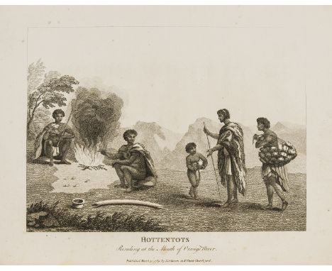
Lot 25
Africa.- Paterson (Lt. William) A Narrative of Four Journeys into the Country of the Hottentots and Caffraria, first edition, without pp.vii-viii as usual, with 17 engraved plates (mostly botanical or natural history subjects), folding engraved map at end, some light foxing and offsetting, original boards, uncut, a little worn and stained, rebacked, new label, 4to, 1789.⁂ One of the earliest descriptions in English of the interior of southern Africa, particularly important for the botanical specimens collected.
Lot 28
Americas.- Chappell (Lt. Edward) Voyage of His Majesty's Ship Rosamond to Newfoundland and the southern coast of Labrador, engraved folding map and 2 plates only (of 3), advertisement leaf at end, spotting and soiling, old library label, original cloth-backed boards, uncut, joints split, spine worn, 1818 § Lyell (Charles) Travels in North America; with Geological Observations on the United States, Canada, and Nova Scotia, 2 vol., folding chromolithographed frontispiece of Niagara Falls, folding hand-coloured engraved geological map, folding map, 3 folding lithographed plates, wood-engraved plate, contemporary ink signature at head of titles, some light soiling, original blind-stamped cloth, spines slightly faded, 1845, first editions, [Sabin 12006 & 42761], 8vo (3)
![Spain.- [Ford (Richard)] A Hand-Book for Travellers in Spain, and Readers at Home, 2 vol., first edition, half-titles, 2 fold](https://cdn.globalauctionplatform.com/45b2b405-2768-4463-9e5c-a8e80105b4ce/877ce974-e78e-48d6-94f6-f37cd0bbdfb3/468x382.jpg)
Lot 35
Spain.- [Ford (Richard)] A Hand-Book for Travellers in Spain, and Readers at Home, 2 vol., first edition, half-titles, 2 folding engraved maps, one laid down on linen, the other in pocket at end of vol.2, also 24pp. pages of advertisements printed on blue paper at end of vol.2, contemporary signature of Ed. Bowen and bookplate of J.W.Bowen on front endpapers, original cloth, rather faded, vol.1 slightly damp-stained, vol.2 with short split to upper joint, John Murray, 1845 § Greene (William) Manuel Matamoros: His Life and Death. A Narrative of the late Persecution of Christians in Spain, ?first edition, with frontispiece of mounted actual photograph of Matamoros in his cell, original cloth, rubbed and damp-stained, 1866; and a Laurie & Whittle folding hand-coloured engraved map of Spain and Portugal dated 1808 in slip-case, 8vo (4)⁂ The first is a classic work of travel-writing and one of Murray's finest handbooks. The second concerns the Spanish Protestant Matamoros who was imprisoned for his prosetylising and became a symbol of religious freedom.
Lot 6
Britain.- Camden (William) Camden's Britannia, Newly Translated into English with Large Additions and Improvements... by Edmund Gibson, engraved portrait frontispiece by R. White, 8 plates of coins and 50 folding double-page maps by Robert Morden mounted on stubs, engraved and woodcut illustrations, one or two full-page, with loosely-inserted later engraved strip road map of road (A6) from Northampton to Market Harborough, ink inscriptions to title (one crossed out, the other faint at head) and another to front free endpaper, portrait and title lightly soiled but generally a good clean copy, small tear to final two leaves (the last causing hole with loss to a few lines of Appendix), contemporary calf, rubbed, gouge to rear cover, corners and spine ends worn, splits to joints, [Wing C359], folio, by F. Collins for A.Swale...and A & J Churchill, 1695.⁂ First edition of Gibson's translation and the first to contain the fine maps by Robert Morden.


Lot 403
RITCHIE HENRY: (1876-1958) Henry Peel Ritchie. British Royal Navy Captain. Ritchie received the first Victoria Cross awarded to naval personnel during the First World War for his courageous actions in November 1914, which left him seriously wounded. Attractive signed printed 5.5 x 4.5 card `H. Peel. Ritchie´, being a printed drawn map entitled `BISERTA´. The map shows the Bizerte lake and city close to the Mediterranean coast, also showing the mountains and lakes surrounding and the roads leading to the city. Boldly signed by Ritchie to the lower white border. Tear to the left lower corner not affecting the map or the signature and small remnants of former affixing to the verso, otherwise about VG £100-150The Victoria Cross is the highest and most prestigious award for valor that can be given to members of the British armed forces. Bizerte, also known as Bizerta, is a town in Tunisia, the northernmost city in Africa.


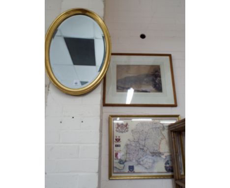
Lot 122
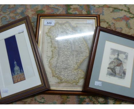
Christopher Greenwood (1786 - 1855) and John Greenwood (fl. 1821 - 1840), Map of the County of Lincoln, from an Actual Survey Made in the Years 1827 & 1828 [...], Published by Greenwood & Co., London, Corrected to the Present Period and Published, January 26, 1831, Engraved by Josiah Neele, vignette of Lincoln Cathedral to margin, steel engraving with hand-colouring, 66cm x 74cm


Lot 732
Various ephemera, prints, pictures, etc., Whose Who In World Cricket, Biographies of Famous World Players, Home Gardener 1967, a News Chronicle 60 Old Time Variety Songs song book, various 20thC coloured postcards, Fraser (Antonia) Cromwell Our Chief of Men, hardback, book plates prints, Silver Jubilee Royal Map of Succession pamphlet, etc. (a quantity)

Lot 537
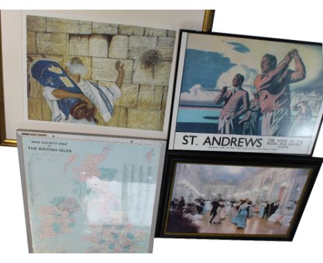
A Nobo Mag-Map of 'New County Map of the British Isles', 85 x 70cm, framed and glazed, a large decorative print of an Edwardian ballroom scene, a printed golf-related poster for 'St Andrews the Home of the Royal and Ancient Game' and a signed limited edition print, no.293/500, a Rabbi with a copy of the Torah in prayerful pose by the Wailing Wall Jerusalem, signed lower-right, 54 x 69cm (3).


Lot 703
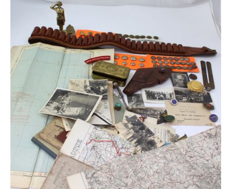
An interesting mixed group of militaria to include WWII period military issue map of Bastia (air) and two early 20th century Ordnance Survey maps of Belgium and Germany, ephemera to include Service and Release books, Signal Wing of School of Infantry booklet, photographs and official documents, also a Christmas 1914 tin, mixed badges and buttons, leather cartridge belt etc.


Lot 266
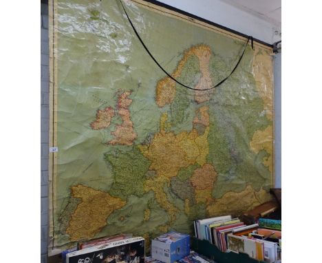
After Richard Bloome, 'A Generall mapp of North Wales' hand coloured engraving, 34 x 46cm (PL), together with a engraved map of England and Wales published by J Badeslade, an 18th century map of Europe titled 'Cumen Historiarum per Occidentem ex Canabitus' by Fran Haraei and an 18th century map of Europe titled 'Europa' by Annae Seile.


-
108737 item(s)/page