We found 109182 price guide item(s) matching your search

Refine your search

Year

Filter by Price Range
  • List
  • Grid
  • 109182 item(s)
    /page

Lot 250

A collection of maps of Arabia comprising `A New Map of Arabia Divided into its Several Regions and Districts`, being a hand tinted map by Monsieur D.Andille, published by Laurie & Whittle, 53 Fleet Street, London, 1794, showing Arabia and various islands around the Red Sea, 47x79cm, unframed, `Carte De L`Entre`e du Golfe de La Merrouge`, being a map showing the Arabian coast with the Isle of Socotra, circa.1780, 33x49cm, unframed, `Persian Gulph`, from the original by D`Anville, showing the various towns around the Persian Gulph, circa.1790, 29x43cm, `A Large Draught of The Coast of Arabia from Maculla to Dofar`, being a hand tinted map with two decorative compass roses, circa.1790, 43x53cm, unframed, `A Plan of the Road of Geddah, on The Western Coast of Arabia in the Red Sea`, by Monsieur D`Apre`s de Mannevillete, printed for R Sayer & J Bennett, Map & Chart Sellers, Fleet Street, London, 1778, 49x33cm, unframed, also a map of Arabia printed by J & F Talis, London & New York, late 19th century, a collection of copies of historic maps of the Gulf, hand tinted map of Delamere Forest, dated 1813, a reproduction map of England after Robert Morden and a modern forestry record map (illustrated)

Lot 252

A collection of antique maps comprising `The County Palatine of Lancaster` by Robert Morden, being a hand coloured map sold by Abel Swale Awnsham & John Churchill, 41x36cm, framed and glazed, `Hampshire` by H Moll geographer, being a hand coloured map circa 1700, showing the various hundreds of Hampshire, decorated to either side with mythical figures to include Bachus, Murcuris etc, 20x33cm, `A Mapp of Devonshire with its hundreds` by Richard Blome circa 1700, being a hand tinted map showing ships at sea and the coat of arms of The Earl of Bath, together with a table of hundreds of Devonshire, 39x31cm, framed and glazed, `Somersetshire` by John Cary engraver dated 1st January 1793, being a double sided hand tinted map with description on verso, 22x26cm, framed and glazed (4) (illustrated)

Lot 253

A hand tinted map of Derbyshire by T Kitchin circa 1747-60, printed for R Baldwin junior at the Rose Inn Paternoster Row, 22x17cm, framed and glazed, also a late 16th/early 17th century engraving of a Biblical scene of a building on fire, bodies being tortured, tied up and mythical man birds, another early 17th century engraving of a group of worthies in discussion, another early 17th century engraving of Jesus performing miracles and a 19th century engraving after Teniers of a man holding a Wheatsheaf

Lot 256

An early 17th century engraved and coloured map of Southern Italy titled `Regno di Napoli`, engraved by Benjamin Wright for Giovanni Antonio Magini`s Italia, 1620, with plate mark, framed and measuring 38cm by 44cm.

Lot 257

Map: a Speed hand coloured map of `Norfolcke`, dated to the back by a description taken from the `Miniature Speed atlas, published 1627`, framed and measuring 9 by 12cm.

Lot 611

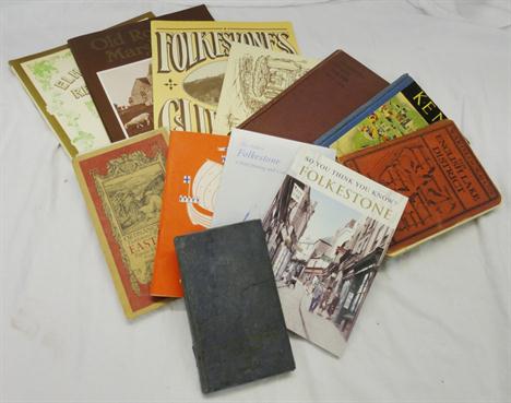
Books Relating To Folkestone & Surround Areas inc. Elham Valley Reflections, Old Romney Marsh In Camera, Folkestone During The War 1914 to 1919, Kent, East Kent Ordnance Survey Map, In Praise of Kent, Rye etc.

Lot 1083

A Phillips tape indicator map of London and other maps and guides

Lot 1186

An `Exide sectional road Map and motorist guide` and a Daily Express New road Book of Great Britain

Lot 1382

A beautifully written Leather bound Journal `Diary of South American Tour, Dec. 1920 to May 1921` by Mr C.H. Leach together with a Book of the Photographs taken and a Map

Lot 1392

An old Framed Map of India in Latin with Camels and Elephants

Lot 2109

A box of prints and watercolours incl. map of Cornwall

Lot 707

A vintage large tubular leather map case with carry strap 32 1/4" long

Lot 446

An EDWARD STANFORD`S folding library map of Europe illustrated and constructed by A. KEITH JOHNSTON, in 48 folding sections, card on linen, hand-coloured

Lot 451

19 various Ordnance maps comprising "Swindon", "Cricklade", "Northleach", "Moreton-in-the-Marsh", "Chipping Norton", "Ross", etc, contained within a leather bound folio, a Bacon`s "New survey map of Staffordshire and Shropshire", a Bacon`s "New Library Map of South Wales", a survey map depicting Richmond and Catterick, and one volume "Devonshire" with county map by ROBERT MORDEN (Ex Dartington Hall Library Devon Collection), leather spine and cloth boards

Lot 497

AFTER EMMANUEL BOWEN "An accurate map of the county of Bedford divided into its Hundreds", bearing shaped cartouche inscribed "To the most noble John Russell, Duke of Bedford", with town index table, coloured engraving, and AFTER ROBERT MORDEN a county map of Bedfordshire, sold by Abel Swale Awnsham & John Churchil, coloured engraving (2)

Lot 322

A small 17th c. map of Worcestershire.

Lot 1052

Railway Books: LSWR by Burtt, LBSC by Morris, Sectional Map of BR by Allan 1948, Big Four in Colour by Jenkinson, Dorset remembered by Oppitz, Woking to Portsmouth by Smith, GW wagons by Russell, BR wagons by Rowland, GWR gas turbines by Robertson, British Locomotives 1825-1925 by Ahrons, RCTS books and other books, G-VG (27)

Lot 452

A hand-coloured Morden map of Northumberland; tog. with a Stanley Minefield Clearance map (2)

Lot 241

Seven various pictures/map and a mirror (8)

Lot 513

A box of books, map etc

Lot 1240

Two wall mirrors, a framed map, a firescreen, etc. (6)

Lot 331

Robert Baugh `Shropshire` engraving, published by Robert Baugh, Llanymynech, August 1st 1808, the map to nine sheets, each unframed and rolled, each approximately 48cm x 48cm

Lot 294

Johannes Blaeu Wallia (Sic), 17th century hand coloured map of Wales

Lot 313

A map of Hertfordshire by Robert Morden

Lot 96

Map of the County of Northampton, from an Actual Survey made in the Years 1825 and 1826, by C. & J. Greenwood, engraved by J. & C. Walker, published by Greenwood & Co, London, 1830, hand-coloured, with an image of Peterborough Cathedral lower right, 57 x 70 cm (22 1/2 x 27 1/2 in)

Lot 313

A `Daily Excursion to Rhyl` poster for the Great Western, London and North Western and Denbigh, Ruthin and Corwen Railways, printed by Gee, Denbigh and dated Denbigh Station, June 1873, 16 x 12 ins and `Railway Clearing House` official railway map of Staffordshire District

Lot 360

William Kipp, After Christopher Saxton, Lecestriae Comitatus, hand-coloured county map of Leicestershire.

Lot 361

Leicestrensis Comitatus, a hand-coloured county map of Leicestershire.

Lot 362

John Speed, Leicester Both Countye and Citie Described, A County Map.

Lot 363

Johan Jansson, Leicestrensis Comitatus Cum Rutlandiae, a hand-coloured county map.

Lot 364

Emanual Bowen, An Accurate map of the Counties of Leicester and Rutland, part coloured county map.

Lot 365

Robert Morden, "Leicestershire" an uncoloured county map.

Lot 1334

A Collection of Framed Railway and Tram Memorabilia, including two displays of badges and buttons, a set of Gallahers `Trains of the World` cigarette cards, Tallis`s Railway Map of Great Britain, two carriage panels, pictures and prints, in two boxes

Lot 292

Malan, H.Noel & Hume, Frank G `Sark, A Practical Guide and map of The Island . 8th Edition (revised). Pamphlet c1909, with detailed information regarding Sark, its people, culture, Glossary of terms used in Sark, with advertisements and folding map.

Lot 789

Three framed reproduction maps, Saxtons map of Durham, and two of Cambridgeshire

Lot 1405

A pair of ivory and gilt brass opera glasses, a pair of faux ivory glove stretchers, a case Moore and Wright micrometer, a map distance calculator and a Rabone boxwood folding pocket rule (crack to ivory eye piece)

Lot 207

Rare WW2 Folded silk RAF Europe escape map used for sewing into a pilots uniform (map covers Eastern Europe/Greece)

Lot 242

A framed Antiquarian map, Scotia Regmum after F.De Witt, 60 x 52cm

Lot 283

A hand coloured print of Aylesbury market square, after Peter Johnson, together with a reproduction map after Saxton of Oxon, Bucks and Berks.

Lot 13

Atkyns (Sir Robert) The Ancient and Present State of Glostershire, W Bowyer for Robert Gosling 1712, first edition: engraved frontispiece of Robert Atkyns by M van der Gucht, title page with woodcut printer`s device, Author`s Epitaph, eight single page engraved coats of arms, double page folding map of Gloucestershire, double page folding plan Gloster City, double page folding engraving West Prospect of Gloster, double page folding engraving Gloster Cathedral, 61 double page engraved bird`s eye views drawn and engraved by Johannes Kip; brown leather covered boards, ribbed spine with gilt tooling and lettering, bears armorial bookplate Cork & Orrery/see illustration.

Lot 55

Orr and Smith (pub)/Ireland/coloured engraved map, 27cm x 21cm (10.75" x 8.25")/Brightly and Kinnersley (pub)/Ireland from the Best Authorities/coloured engraved map, 20cm x 23cm (8" x 9") /and seven unframed hunting prints, 31cm x 23cm (12" x 9") .

Lot 564

Map: Leicestershire - Spede van den Keere.

Lot 566

Strip Map: Stony Stratford to Derby - Ogilby .

Lot 576

Estate Map: Lord Ailesford, Shoby, Grimston & Saxelby.

Lot 279

18th century hand coloured map of Poole and 2 Antique maps of South America, (3), framed.

Lot 1297

A Cantonese carved ivory rectangular visiting card case, the exterior panels carved as figures in garden scenes and a rectangular base metal cigarette case, the cover decorated with a map of Jamaica.

Lot 542

After Blome, "A General Map of South Wales", uncoloured, framed & glazed.

Lot 602

After Robert Mordon, uncoloured map of South Wales, framed & glazed together with another after Walker, "Northampton shire" framed & glazed. (2).

Lot 134

Three hand-coloured road maps, published by Laine & Whittle 1815, a hand-coloured map of Essex engraved by J Harrison 1787 and various other local maps

Lot 226

A quantity of watercolours and prints, and a map

Lot 492

ABRAHAM ORTELIUS.A map of French Burgundy, later hand coloured, latin text verso, unframed,14 1/2 x 20 in

Lot 74

Scarce silk printed handkerchief commemorating the Coronation Durbar Delhi 1911 with views of processions and map of events Further images and condition reports are available at www.reemandansie.com

Lot 89

A Collection of Militaria, including a 1 3/4inch brass three draw telescope by B.C.Ltd.& Co., stamped TEL.SCT.REGT.Mk.IIs 25006 O.S.126.G.A with brown crinkle enamel sleeve, three O.R. white leather waistbelts, two stable belts, a sergeant`s pace making stick, a walking cane to the Royal Corps of Signals, three signalling flags, nine various prints, a canvas map case etc

Lot 234

A French Model 1866 `Chassepot` Yataghan Sword Bayonet, with black painted steel scabbard; a German Model S84/98 Knife Bayonet, with steel scabbard; a US Model 1913/17 Sword Bayonet by Remington, with steel mounted leather scabbard and webbing frog; two British Pattern 1907 Mk1 `SMLE` Short Magazine Lee-Enfield Bayonets, each with steel mounted leather scabbard, one with leather frog; a Parachutist`s Type Knife, with single edge steel blade enclosed by the centre folding chequered black steel two piece grip; a Gilt and Silvered Metal Cigarette Case, engraved and dot enamelled with a map of the US Occupation Zone 1946. (7)

Lot 432

An 18th century map of Glamorgan by Hole, 28 x 34cm

Lot 434

A map of Monmouthshire by Saxton engraved by William Hole, 28 x 35cm

Lot 435

An 18th century map of Somerset by Saxton engraved by William Hole, 28 x 39cm

Loading...Loading...
  • 109182 item(s)
    /page

Recently Viewed Lots