We found 109198 price guide item(s) matching your search
There are 109198 lots that match your search criteria. Subscribe now to get instant access to the full price guide service.
Click here to subscribe- List
- Grid
-
109198 item(s)/page


Lot 263
A set of linen backed hunt maps by A H Swiss, Devonport, including: 'South Devon hunt map, including a portion of East Cornwall', 66x92cm; 'The Hampshire, East Wiltshire, West Surrey, and West Sussex District', 79x101cm; East Cornwall; The Dorst, Wilts. Somerset, etc; North Devon; The Hampshire; Oxfordshire; Hertfordshire (8)


Lot 140
SAVOYBLAEU (WILLEM) Sabaudia Ducatus Savoye, hand-coloured engraved map, decorative cartouche flanked by 2 putti holding the coat of arms of the House of Savoy, marginal damp-staining, framed and glazed, sheet: 485 x 590mm, image: 380 x 500mm, Amsterdam [c.1635-1650]Footnotes:Blaeu's early map of Savoy, showing Geneva, Lake Geneva and Grenoble. It appeared in the 1634 edition of Blaeu's Atlas Novus.This lot is subject to the following lot symbols: •• Zero rated for VAT, no VAT will be added to the Hammer Price or the Buyer's Premium.For further information on this lot please visit Bonhams.com


Lot 139
MAUDE PARKER, R.W.A: "FISHERMAN'S MAP OF SALMON POOLS ON THE RIVER DEE" 1931; J. Bernard & Sons, Jermyn Street, London 1909-1910 Fishing Tackle Catalogue; and The Army & Navy Stores Ltd, London general price list 1935-1936, a J. Bernard & Son of German St London, 1909-1910 fishing tackle catalogue (4)Provenance: From a private East Sussex vintage fishing tackle collection.

Lot 653
A large map of Loch Lomond, engraved 1862, this being the later corrected version (1953), framed under glass and measuring approx. 105cm x 73cm; together with two framed books published by Blackie & Son, with covers designed by Charles Rennie Mackintosh (2) Condition Report:Available upon request

Lot 110
WEDGWOOD; a boxed set of white stone encrusted silver plated napkin rings, a boxed Royal Doulton giftware cut glass crystal box and lid of lozenge form, length 15cm, a boxed Murano blown glass and stainless steel bottle stopper, and a stainless steel cigarette case with map of Africa to the front, length 13cm (4).

Lot 704
GEORGE ANSON ESQ; 'A Voyage Round the World in the Years MDCCXL, I, II, III, IV', now Lord Anson Commander in Chief of a squadron of his Majesty's ships sent upon an exhibition to the South Seas, compiled from his papers and materials by Richard Walter, MA, chaplain of his Majesty's ship The Centurion, in that expedition, with charts of the south part of South America, of part of the Pacific Ocean and of the track of the Centurion round the world, 7th edition, printed for John and Paul Knapton, in Ludgate Street, MDCCLIII (1753), with map to the front and back.Condition Report: Cannot confirm all pages are present, boards have been detached, maps worn with splits and tears, in need of restoration

Lot 712
'The Universal Magazine of Knowledge and Pleasure with Essays Literature Arts and Sciences', Vol LVI and LVII, with etchings and plates to include a rare 18th century etching, 'A View of The City of Boston, Capital of New England', original fold-out book insert, original drawing by Gov. Pownal, painted by Pugh, and engraved by PC Canot, dated in pen to the top 1804, indistinct writing to one side, insert 20 x 33cm.Condition Report: There is a poor condition map of North America (see additional images)All items appear to be in the two volumes

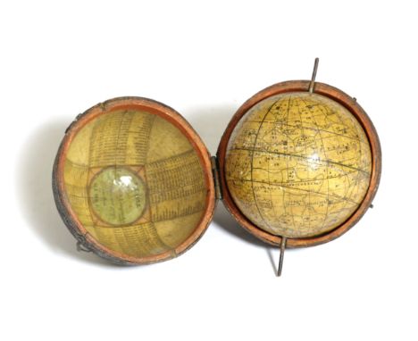
Lot 309
A GEORGE III CELESTIAL POCKET GLOBE BY JOHN AND WILLIAM CARY, LATE 18TH / EARLY 19TH CENTURYthe 3in globe displaying 24 stars and Ptolemaic constellations, with a cartouche inscribed 'New Celestial Globe' and 'Pub'd by J & W Cary, Strand', with two metal pivots at the poles, in a shagreen case, the interior with a 'Table of Latitudes & Longitudes of Places not given on this Globe' and a map of 'The World as known in Caesar's Time agreeable to D'Auville'9.2cm diameterCatalogue NoteThe Cary family firm was established in the late 18th century by John Cary (1755-1835) a noted map seller and his brother William (1758-1825) an optician and nautical instrument maker. The firm published their first globes in 1791 advertising in the 'Traveller's Companion' where it stated they made terrestrial and celestial globes in 3, 9, 12 and 21in diameter sizes 'from entire new plates'.

Lot 562
A VICTORIAN HAND-DRAWN AND PAINTED HISTORY OF ENGLAND AND WALESC.1860the central map of the realm surrounded by shields giving the names and dates of key periods, monarchs and characters from pre-Roman Britons to Queen Victoria, with two rondels giving events through out Queen Victoria's life, in a glazed frame58.5 x 70cm


Lot 454
M SHAFER, pair, of gilt framed and glazed watercolours, labelled to gilt mount, "Arras & Louvrain" signed lower left "Louvring Belgium Shafer, and the other arras France; and Quantity of framed and glazed black and white lithographs, prints etc of architectural interest; and an Antique style map, "Hertford", AND a quantity of unframed black and white etching prints of architectural buildings and landscapes and another modern print

Lot 492
Glazed and gilt framed military pictures, The Bombardment of Sveaborg, officers on the island of Tona Miola by J W Carmichael; The Baltic fleet "The Archer" in the Ice in Wingo Bay; larger , image 18 x 25; and another part gilt glazed coloured illustration, "Ou @Art De La Guerre" ( "All the art of War"); and a quantity of other small pictures and prints in wooden frames, and a print of an Antique map of table mountain.


Lot 20
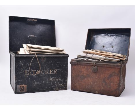
Bath local history / interest - a collection of mostly Victorian 19th Century Bath related ephemera, presented in two vintage tin safe cases likely previously in the possession of a solicitor or banker. The contents to include indentures, deeds, receipts, wills, probates, paperwork, an architect's sketch map, letters, cheque books etc. With deeds relating to the estates of Ellen Bernard, Henry Hancock, Morgan Joseph Esq., Dora Twyford, and others. Oldest indenture to date to 1812, with many relating to land in Batheaston, Lyncombe, Widcombe, etc. Including an interesting architect's plan depicting the improvement to James Street signed Charles [Chas.] R. Fortune, 1907. Oldest indenture dated 1841. Presented in two early-mid 20th Century tin safekeeping boxes, one produced by E. Tucker of Weston, the other unmarked. Larger tin measuring approx. 32cm x 39cm x 30cm.

Lot 174
An assortment of Victorian 19th Century & later wooden lidded pots / tureens. The lot comprising of a matryoska style Tunbridge ware graduating lidded pots, a hand painted lidded pot with map of the world possibly tape holder, a walnut veneered lidded pot, together with a selection of sewing portable tools. Approx. seven items. Largest measuring approx. 6cm x 7cm.
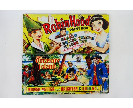
Lot 309R
MAP - Vintage Paint Tins / Pallets. A selection of Two vintage 1950/60/70's era, lithographed water colour tin paint sets appearing in Excellent condition with light scuffs and signs of rust appearing. Manufactured by MAP, a British maker of quality paint boxes with fine lithograph colours. The MAP logo is depicted on the lid. No lithographer is identified. “Made in England” is printed on the paint tray insert inside. Much like Page London, MAP paint sets typically depict children painting a scene of whatever they are observing at the time and display "Childhood memories" or hot topics. Lot consists of: Robin Hood Paint Box and Treasure Island Paint Box. Both Measure: 206mm x 518mm x 18mm. (This does not constitute a guarantee).
-
109198 item(s)/page