235
Low, E. 1800 North Carolina from the Best Authorities This is an early map of the state of North

Interested in the price of this lot?
Subscribe to the price guide

Description
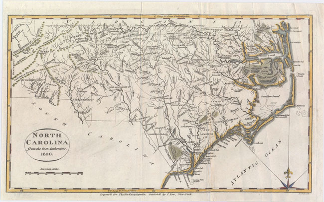
Low, E. 1800 North Carolina from the Best Authorities This is an early map of the state of North Carolina, which is a reduced version of Reid’s map of 1796. The map shows fine detail of watershed, towns, wagon roads, and mountains. There is particular emphasis on the Outer Banks. It locates Roanoke Island, Cape Fear, the "Great Alligator dismal Swamp" along the southern edge of the Albemarle Sound, and the "Gr. Dismal Lebanon Swamp" along the northern edge. 12.7" W x 7.4" H Issued folding with a 2" split near the fold at bottom right that has been closed with archival tape on verso and some extraneous creases.
Auction Details
Shipping
T&Cs & Important Info
Ask seller a question
Low, E. 1800 North Carolina from the Best Authorities This is an early map of the state of North Carolina, which is a reduced version of Reid’s map of 1796. The map shows fine detail of watershed, towns, wagon roads, and mountains. There is particular emphasis on the Outer Banks. It locates Roanoke Island, Cape Fear, the "Great Alligator dismal Swamp" along the southern edge of the Albemarle Sound, and the "Gr. Dismal Lebanon Swamp" along the northern edge. 12.7" W x 7.4" H Issued folding with a 2" split near the fold at bottom right that has been closed with archival tape on verso and some extraneous creases.
Antique Maps, Charts, Atlases, Books, Prints, and Medieval Manuscripts – Online bidding through Nov. 20 at 10pm EST USA (3am UK time)
Sale Date(s)
Venue Address
ONLINE ONLY
.
United States
General delivery information available from the auctioneer
We have a full service shipping department to ensure proper packing and safe delivery of purchases at reasonable cost. We are specialists at packing and shipping antique maps, books and works on paper. All lots purchased by the same client are combined for shipping in order to keep the cost as economical as possible. Domestic shipments are typically sent UPS Ground or USPS Priority Mail, but we can accommodate other shipping preferences. For international orders we select the most appropriate carrier depending on the value and weight of the items purchased. We are happy to accommodate special arrangements by request.
Important Information
Information:
FREE LIVE BIDDING – Please note that bids must be placed on www.oldworldauctions.com. You may register to bid up until the close of the auction.
For additional images, full descriptions, and condition statements, please visit www.oldworldauctions.com
Buyer’s Premium 15% for all items
Viewing is available by appointment at 4449 Cox Road, Glen Allen, Virginia 23060, USA. Please call +1-804-290-8090 to schedule an appointment.
Shipping: Old World Auctions offers in-house packaging and shipping for all items. They ship to over 70 countries worldwide via UPS, DHL, USPS, and Fedex. They add a specific shipping fee to all invoices sent out based on the actual cost of shipping and in-transit insurance.