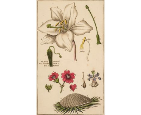

Wakefield (Priscilla). An Introduction to Botany, in a series of Familiar Letters..., to which is added, The Pleasures of Botanical Pursuits. A Poem, by Sarah Hoare, 9th edition, London: Harvey and Darton [et al], 1823, 9 hand-coloured engraved plates including frontispiece, folding table, some offsetting and toning, endpapers renewed, contemporary calf, rebacked and corners repaired, red morocco title label to spine, 12mo, together with:[Newton, James]. [A Compleat Herbal of the late James Newton, M.D. containing the prints and the English names of several thousand Trees, Plants, Shrubs, Flowers, Exotics, &c. all curiously engraved on cooper-plates, London: E. Cave [et al.], 1752], engraved portrait frontispiece and 175 plates, bound without text leaves (title, dedication, preface, 3 leaves of table of authors and 3 leaves of index), index at rear provided in 5 folding leaves of manuscript written in a neat hand, plates from 165 onwards incorrectly numbered and corrected in a contemporary hand, contemporary diced calf, gilt decorated spine with green morocco title label, joint and head of spine rubbed, 8vo,Smith (James Edward). A Grammar of Botany, illustrative of Artificial, as well as Natural, Classification, with an explanation of Jussieu's System, 2nd edition, London: Longman, Rees, Orme, Brown, and Green, 1826, 21 hand-coloured engraved plates, spotting mostly to title and final leaf, light offsetting from plates, contemporary half calf, gilt decorated spine, joints and foot of spine strengthened, 8vo,Miller (Phillip). The Gardeners Kalendar; Directing what Works are necessary to be performed every Month in the Kitchen, Fruit, and Pleasure-Gardens, as also in the Conservatory and Nursery..., 14th edition, London: Printed for the Author, 1765, engraved frontispiece, five folding engraved plates, Eardiston armorial bookplate to upper pastedown, contemporary calf, worn at head and foot of spine, 8vo,Lindley (John). Ladies' Botany: or a Familiar Introduction to the Study of the Natural System of Botany, 2 volumes, London: James Ridgway and Sons, 1837, 50 hand-coloured engraved plates, top edge gilt, later 19th-century green morocco-backed cloth by Birdsall & Son of Northampton, some cracking and wear to joints and extremities, 8vo, plus other 18th-early 20th century natural history and botany relatedQTY: (15)
We found 1181390 price guide item(s) matching your search
There are 1181390 lots that match your search criteria. Subscribe now to get instant access to the full price guide service.
Click here to subscribe- List
- Grid
-
1181390 item(s)/page
![E[velyn] (J[ohn]). Acetaria. A Discourse of Sallets, 1st edition, London: Printed for B. Tooke, 1699, folding table, spotting](https://cdn.globalauctionplatform.com/910db78b-cd1e-4760-a5d0-b0dc011def41/76fce894-0202-4467-a70e-b11e012078f1/468x382.jpg)
E[velyn] (J[ohn]). Acetaria. A Discourse of Sallets, 1st edition, London: Printed for B. Tooke, 1699, folding table, spotting and browning throughout, lacks initial blank and final errata leaf, title frayed along gutter margin and near detached, bookplate of ‘Capt. W. Hext, R. N., Lancarfe’, contemporary panelled calf, some wear with leather loss from biopredation, 8voQTY: (1)NOTE:Bitting p. 149; Cagle 669; Hunt 401; Henrey 117; Keynes 105; Oxford p. 46; Wing E3480. First edition of this uncommon ‘cookery-garden book with excellent recipes for unusual dishes of all sorts flavoured with the ever useful pot herbs grown so universally in the 17th century’ (Hunt).
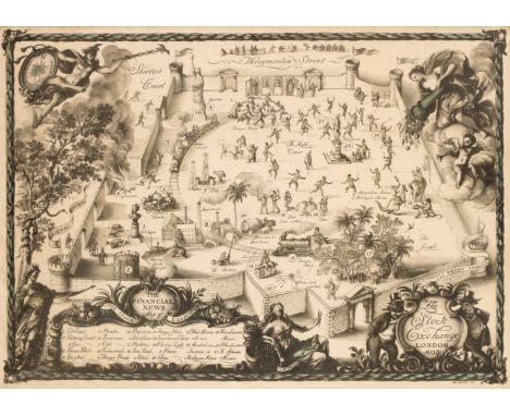
* The Stock Exchange. Whistler (Reginald John, 'Rex'), The Stock Exchange London 1933, London: The Financial News, 1933, colour photolithograph, additional cartouche with the title 'The Financial News map of the Stock Exchange' with a table of explanation below, numerous allegorical symbols and figures surrounding the map, slight marginal staining, laid on later card, 390 x 535 mm, framed and glazedQTY: (1)NOTE:A scarce map crammed with allegorical symbolism. The cartouche is supported by a bear and a bull, the classic representations of a sellers and buyers market, and both are shown in morning dress. The secondary cartouche is flanked by King Midas who has coins spilling from his waist and Dame Fortune who is blindfolded and holding a pair of scissors and whose arm rests on the 'rota fortunae' or wheel of fortune, a symbol of the capricious nature of fate. In the upper corners of the map are representations of Mercury carrying an elaborate compass and the goddess Demeter spilling her cornucopia into the market. The stock exchange itself is shown as a castellated courtyard within whose walls commodities, gilts and bonds are depicted being traded by a variety of humorous vignettes.
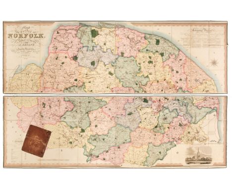
Norfolk. Bryant (Andrew), Map of the County of Norfolk from Actual Survey by A. Bryant in the Years 1824, 1825 and 1826, Respectfully dedicated to the Nobility, Clergy & Gentry of the County, published A. Bryant, Dec. 1st. 1826, large-scale engraved folding map on two sheets, bright contemporary hand colouring, sectionalised and laid on linen, calligraphic cartouche, list of the ecclesiastical divisions, compass rose, table of explanation and uncoloured engraved vignette of Norwich Cathedral, slight offsetting, bordered with green silk, each sheet approximately 750 x 2275 mm, contained in a contemporary sheep book box, box heavily worn and frayed with one section near detachedQTY: (1)NOTE:T. Chubb. A Descriptive List of the Printed Maps of Norfolk 1574 - 1916, page 106.
Barclay (Rev. James). A Complete and Universal Dictionary of the English Language..., A New Edition, George Virtue, circa 1845, portrait frontispiece of Queen Victoria, additional decorative title and half-title, 10 uncoloured engraved plates and fifty uncoloured engraved maps by Thomas Moule, a few maps trimmed with slight loss, chronological table bound at the rear, some water staining to the preliminaries, later endpapers, later half calf with contrasting morocco gilt label to the spine, 4toQTY: (1)
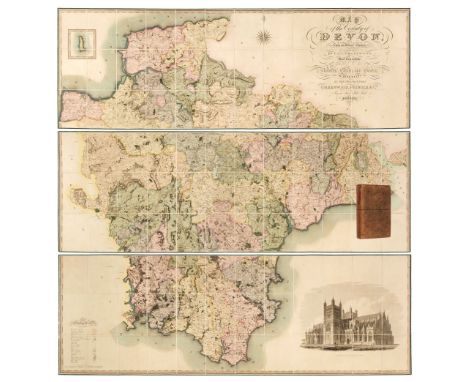
Devon. Greenwood (C. & J.), Map of the County of Devon from an Actual Survey, made in the Years 1825 & 1826 by C. & J. Greenwood, most Respectfully dedicated to the Nobility, Clergy and Gentry of the County, by the Proprietors Greenwood, Pringle and Co., February 20th, 1827, large scale engraved map on three sheets, sectionalised and laid on linen with bright contemporary wash colouring, inset map of Lundy Island, calligraphic cartouche, compass rose, table of explanation, uncoloured engraved vignette of the 'North West View of Exeter Cathedral', slight offsetting and spotting, each sheet edged in green silk, each sheet approximately 645 x 1905 mm, contained in a contemporary tree calf book box with a contrasting red morocco gilt label to spineQTY: (1)NOTE:Batten & Bennett. The Printed Maps of Devon, number 96.

Geological Maps. Wyld (James), Map of the United Kingdom of Great Britain and Ireland, circa 1850, engraved map with contemporary wash colouring, sectionalised and laid on linen, inset map of the Shetland Islands, slight dust soiling and staining, a statistical table and a table of references, 485 x 375 mm, contained in a contemporary cloth slipcase with publisher's printed label to the upper cover, slipcase a little worn and faded, together with Walker (J & C). Geological Map of England and Wales, published for the Society for the Diffusion of Useful Knowledge, arranged by Roderick Impey Murchison, 1843, engraved map with contemporary wash colouring, 390 x 320 mm, with Geological Map of England & Wales, circa 1900, unattributed colour lithographic map on two sheets with inset table of references and cross-sections, each sheet approximately 315 x 495 mm, plus Geological Survey of England and Wales (publishers). Isle of Wight, 1947, colour photolithographic map, slight creasing, 510 x 690 mmQTY: (4)
![* Thackeray (Lance). A Billiard Match, "Left", "Kissing", "The Cannon" [and] "Snookered", Landeker & Brown, 1902, a set o](https://cdn.globalauctionplatform.com/910db78b-cd1e-4760-a5d0-b0dc011def41/2beaf32d-5d5d-4677-8258-b11e011ecbd0/468x382.jpg)
* Thackeray (Lance). A Billiard Match, "Left", "Kissing", "The Cannon" [and] "Snookered", Landeker & Brown, 1902, a set of four humorous photolithographs of an attempted courtship during a game of billiards, interrupted by a cleric, overall each approximately 385 x 505 mm, uniformly framed and glazed, together with Chabet (C. publisher). The Interior of a Billiard Room, with Thurston's Table, Improved Revolving lamp and Furniture Complete, circa 1870, hand-coloured lithograph, old folds, 250 x 380 mm, mounted, framed and glazed, with Ansell (Charles). A new way of paying Debts of Honor, S. W. Fores, June 28th 1800, etching with contemporary hand-colouring, some spotting, 230 x 345 mm, mounted, framed and glazedQTY: (6)
![Bible [English]. The Bible: Translated according to the Ebrew and Greeke, and conferred with the best Translations in divers](https://cdn.globalauctionplatform.com/910db78b-cd1e-4760-a5d0-b0dc011def41/612b0e6e-848b-48bd-8b78-b11e011f4226/468x382.jpg)
Bible [English]. The Bible: Translated according to the Ebrew and Greeke, and conferred with the best Translations in divers Languages..., Imprinted at London by Robert Barker, 1614/13, general title and New Testament title within woodcut border (imprint to general title dated 1614 and imprint to New Testament title dated 1613), text in double-column black letter, Apocrypha present, lacking blank before New Testament title and first leaf of 'Certaine questions and answers...' (following NT title), few leaves with early ownership inscriptions including several of William and Thomas Speechly(?), some light worming to lower blank margins with occasional discreet repairs, light cropping to few running titles, bound with at rear Concordance. Two right profitable and fruitful Concordances, or large and ample Table Alphabeticall..., Collected by R. F. H., Imprinted at London by Robert Barker, 1613, early manuscript ownership inscriptions to verso of title and final leaf, dust-soiling throughout volume, some damp-staining mostly to margins, spotting and few other marks, modern blind panelled calf, 4to (21.4 x 15.5 cm)QTY: (1)NOTE:Darlow and Moule 256; Herbert 330; STC 2232.This volume is bound without Speed's Genealogies and map which is sometimes present.
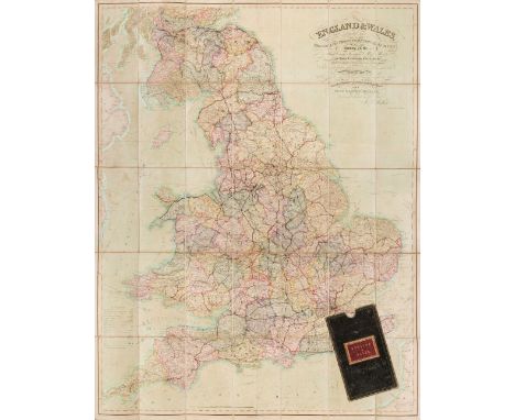
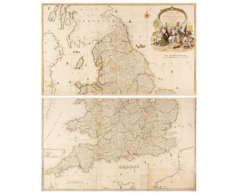
England & Wales. Walker (J & C), England & Wales founded upon the Grand Trigonometrical Survey, Shewing all the Mail Coach, Turnpike & Rail Roads, the Rivers & Navigable Canals, also the Boundaries & Divisions of Counties..., circa 1850, engraved map with contemporary wash colouring, sectionalised and laid on linen, slight staining and spotting, calligraphic title and table of explanation, 1300 x 1030 mm, contained in a contemporary green morocco gilt slipcase with red morocco gilt label to the upper cover, some wear to extremities, together with another copy similar (dated 1845) with some offsetting from the calligraphic title, contained in a contemporary cloth slipcase, with Wyld (James. successor to Mr Faden). A New Map of England & Wales Projected upon the Trigonometrical Operations made for the General Survey of the Kingdom, January 1st 1836, engraved map with contemporary wash colouring, sectionalised and laid on linen, table of the 'Altitudes of the Principal Mountains', and table of explanation, slight offsetting, edged in green silk, advertisement endpapers, 1250 x 950 mm, contained in a contemporary cloth slipcase with publisher's printed label to the upper cover, slipcase worn and frayed, plus Mogg (Edward). Map of the United Kingdom of Great Britain & Ireland with the adjacent parts of the Continent from Amsterdam to Paris and Brest..., January 1st 1834, engraved map with contemporary wash colouring, sectionalised and laid on linen, with an additional title above the map 'Mogg's Map of Steam Navigation', inset map of the Shetland and Orkney Islands, table of reference and compass rose, very slight staining, 770 x 610 mm, advertisement endpapers, contained in a contemporary blue card slipcase with publisher's printed label to the upper cover, slipcase worn and frayed at extremities, and Sayer (Robert). An Accurate Modern Map of England and Wales, drawn from the latest Surveys, Corrected & Improved by the Best Authorities, circa 1775, an engraved map with contemporary outline colouring, sectionalised and laid on linen, some staining and dust soiling, slight wear where old folds cross, 480 x 405 mm, contained in a contemporary marbled card slipcase with a near-contemporary manuscript ownership signature to the upper cover, slipcase worn and frayed, with Wyld (James). Wyld's Road Director through England and Wales being a New and Comprehensive Display of the Roads and Distances from Town to Town and of each Remarkable Place from London, 1851, lithographic folding map with contemporary outline colouring, laid on linen, slight offsetting, bound in contemporary cloth boards with publisher's label to the upper cover, some wear to extremitiesQTY: (6)

* Terrestrial Globe. Philip (George & Son), 12 Inch Terrestrial Globe, circa 1925, twelve-inch table globe with twelve colour lithographic globes, oval cartouche, analemma and reference to states in the U. S. A. slight chipping to the printed image, bronze graduated meridian ring, presented on a turned stained wooden stand, height 600 mm QTY: (1)
Serres (John de). A General Inventorie of the History of France, from the beginning of the Monarchie, unto the Treatie of Vervins, in the yeare 1598,...translated by Edward Grimeston, London: George Eld., 1607, engraved title page plus further in-text illustrations & vignettes, later inscription to the head of the title page, bookplate to the front pastedown, gutters cracked, some marginal toning, lacking final page of 'The Table' to the rear, later embossed full calf, boards & spine rubbed with some loss, folio, together with:Mill (James), The History of British India, 3 volumes, London: printed for Baldwin, Cradock, and Joy, 1817, some repaired slight damage to the foot of the title page to volume 1, lacking a map in volume 2, some light spotting & toning throughout, contemporary uniform gilt decorated plum half morocco, boards & spines slightly rubbed, large 4to, plusCampbell (J.), Lives of the British Admirals: containing a new and accurate Naval History, from the earliest periods, 4 volumes, London: printed for Alexander Donaldson, 1779, period inscriptions to the front endpapers of volumes 1 & 2, 4 engraved frontispieces, 4 folding maps, bookplates to the front pastedowns, gutters cracked, some marks & light marginal toning, contemporary uniform full calf, hinges cracked, boards & spines slightly rubbed with some minor loss, 8vo, and other 18th & 19th century literature, mostly contemporary leather bindings, some odd volumes, overall condition is generally fair/good, 8vo/folioQTY: (6 shelves)
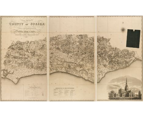
Sussex. Greenwood (C. & J.), Map of the County of Sussex from an actual Survey made in the Years 1823 & 1824..., Greenwood Pringle & Co., March 24th, 1825, large scale uncoloured engraved map, sectionalised and laid on linen, in three sections, calligraphic title, engraved vignette of Chichester Cathedral and table of reference to the hundreds, slight staining, 1250 x 2020 mm, marbled endpapers, contained in contemporary cloth slipcaseQTY: (1)
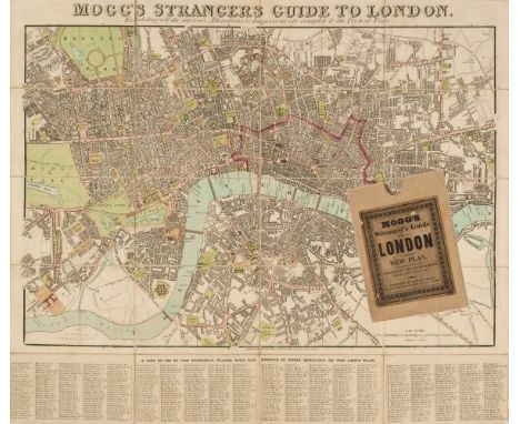
London. Mogg (Edward), Mogg's Strangers Guide to London, exhibiting all the various alterations & improvements complete to the present time, January 1st. 1837, engraved map with contemporary outline colouring, sectionalised and laid on linen, with 'A List of 500 of the Principal Places with References to their Situation on the Above Plan' below the map, very slight dust soiling, 500 x 570 mm, card endpapers with a contemporary manuscript ownership inscription, contained in a later card slipcase with a contemporary label to the upper cover, together with Cruchley (George Frederick). Cruchley's New Plan of London Shewing All the New and Intended Improvements to the Present Time, 1830, engraved map with contemporary outline colouring, sectionalised and laid on linen, table of references to both vertical margins and the lower horizontal margin, marbled endpapers, one with a publisher's advertisement, 425 x 595 mm, contained in a contemporary marbled card slipcase with a publisher's yellow printed label to the upper cover, slipcase wornQTY: (2)NOTE:The first described item. J. Howgego. The Printed Maps of London, number 238, state 9. The second item, number 307, state 4.
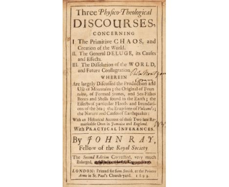
Ray (John). Three Physico-Theological Discourses Concerning The Primitive Chaos, and Creation on the World..., 2nd edition, London: Printed for Sam[uel] Smith, at the Princes Arms in St. Paul's Church-Yard, 1693, erasure and previous owner inscription to title page dated 1852, book stamp of Robert Montgomery and previous ownership inscription to front pastedown, ownership inscription to verso of G8 fore margin, later endpapers, closed tear to lower outer corner of E2, lacking plates, contemporary blind panelled calf with some surface mottling, some loss to spine, head, foot and joints repaired, lower outer corner to upper board repaired, title label replaced, 8vo, together with;Worlidge (John). Systema Horti-cultura: or, the Art of Gardening..., 2nd edition, London: Printed for Tho[mas]. Dring at the Harrow over against the Inner-Temple Gate in Fleetstreet, 1683, previous ownership inscription dated 1705 to preface, ink staining to verso of title page, trimming to upper margin affecting headline, book ticket to Harrison D. Horblit and book ticket for Mr. G. L. Wintle to front pastedown, bookplate of John. T. Beer to front free endpaper, endpapers renewed, 20th-century quarter calf gilt, 8vo andTurner (Robert). Botanologia. The Brittish Physician: or, The Nature and Vertues of English Plants. Exactly describing such Plants as grow Naturally in our Land, with their several Names, Greek, Latine, or English, Natures, Places where they grow, Times when they flourish, and are most proper to be gathered..., London: Printed for Obadiah Blagrave, at the Black Bear and Star in St. Pauls Church-Yard, over against the Little North-Door, 1687, facsimile frontispiece, title page laid on later paper, alphabetical table and table of diseases to rear, some toning and damp staining, a few repaired closed tears, modern endpapers, modern half-calf by Richard Lane, Fakenham, gilt spine with morocco title labels, 8vo QTY: (3)NOTE:Provenance: Robert Montgomery (book stamp), for Ray (John).Harrison D. Horblit (book ticket), Mr. G. L. Wintle (book ticket) and John. T. Beer (bookplate) for Worlidge (John).Wing R409 for the first work, Wing W 3605; Henrey p. 276 for the second and Wing T3329 for the third.
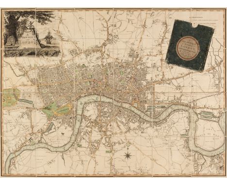
London. Laurie & Whittle (publishers), A New Map of London, November 8th. 1800, engraved map with contemporary outline colouring, sectionalised and laid on linen, title cartouche of a ruined pyramid, a beehive, a ship, flag and anchor, table of explanation, 585 x 780 mm, contained in a contemporary marbled card slipcase with circular engraved label to upper cover, slipcase worn QTY: (1)NOTE:J. Howgego. Printed Maps of London, number 231. Unrecorded state published before Howgegos's first entry of 1804. This example may be the first edition as the 1804 edition is recorded as the '3rd. edition'.
Ireland. Taylor (John), Taylor's Map of the Environs of Dublin, extending 10 to 14 Miles from the Castle, by Actual Survey on a Scale of 2 Inches to 1 Mile, Dublin, 1816, engraved map with contemporary wash colouring, sectionalised and laid on linen, table of explanation, dedication and a note of the banks in Dublin Bay, 900 x 805 mm, contained in a contemporary marbled card slipcase, case worn and frayedQTY: (1)
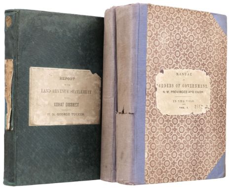
Tucker (H. St. G). Report on the Settlement of the Kohat District in the Panjab, Calcutta: Calcutta Central Press Company, 1884, folding genealogical table, folding table, lacking map in pocket, rear hinge cracked, a few gatherings loose, lightly toned, original green cloth, paper title label to upper cover and spine (label to spine mostly lacking), rubbed and marked, 8vo, together with:North Western Provinces and Oudh. Orders of the Government, N.-W. Provinces and Oudh, 2 volumes, Allahbad: North-Western Provinces and Oudh Government Press, 1882, contemporary ownership inscription of 'High Court N. W. P.' to head of volume one title (with a few further pencil marks to both titles), errata slip to volume one, toned, a few leaves frayed, hinges cracked with text block loose in volume one, original blue cloth-backed decorative boards, paper title labels to upper covers, split to backstrip of volume one, backstrips faded, 8voQTY: (3)NOTE:Both works exceedingly rare. Institutionally the first work is held at four locations (British Library, University of Cambridge, University of Oxford and National Library of Scotland) and we cannot trace another example appearing commercially. The second work we cannot trace either institutionally or in commerce.

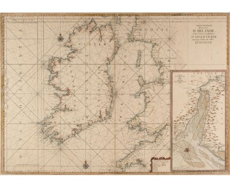
Ireland. Van Loon (Hermanus.), Carte Generale des Costes D'Irlande et des Costes Occidentales D'Angleterre avec une Partie de celles D'Ecosse, [1661 or later], large hand-coloured sea chart of Ireland and the west coast of England & Wales, inset map of the River Dee and Chester, compass rose and numerous rhumb lines, narrow margins, slight spotting, 610 x 870 mm, together with Taylor (Alexander). A New Map of Ireland having the Great Features of the Country described in a Manner Highly Expressive..., New Edition, James Wyld, Successor to Mr Faden, June 1st. 1827, engraved map with contemporary wash colouring, sectionalised and laid on linen, decorative cartouche and dedication and table of references, toned overall short splits along old folds, one section torn and detached, 740 x 610 mm, contained in a near-contemporary cloth slipcase (not uniform with the map), the slipcase worn and rubbed, with Forster & Co. (publishers). Geological Map of Ireland to Accompany the Instructions to Valuators..., Sold by Hodges & Smith, Dublin, August 1853, colour-lithographic map, sectionalised and laid on linen, inset tables and cross-section, 515 x 360 mm, marbled endpapers and bound in contemporary cloth boards with publishers printed label to the upper cover, board size 145 x 100 mmQTY: (3)

Culpeper (Nicholas). The English Physitian Enlarged: With Three Hundred, Sixty and Nine Medicines made of English Herbs that were not in any Impression until this..., London: Printed by Peter Cole in Leaden-Hall, and to be sold at his Shop at the sign of the Printing-press in Cornhil, neer the Royal Exchange, 1653, title page tipped in with slight loss to margins, vertical half-title bound in after alphabetical table, lacking portrait, some water staining, spotting and fraying throughout, contemporary brown morocco skilfully re-backed, gilt lettering to spine, minor wear to extremities, 8vo QTY: (1)NOTE:Henrey 87; Wing C7502.
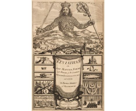
Hobbes (Thomas). Leviathan, or The Matter, Forme, & Power of a Common-Wealth Ecclesiasticall and Civill, 1st edition, 1st issue, London: Printed [by Thomas Warren and Richard Cotes] for Andrew Crooke, at the Green Dragon in St. Pauls Church-yard, 1651, 1-248, 247-256, 261-396 pp., additional pictorial engraved title by Abraham Bosse, with manuscript signature to lower blank margin 'W. Best' [?] dated 1713, letterpress title with woodcut ornament with head motif (indicating the first issue), folding letterpress table, errata list struck through in early ink to verso of A3, several leaves at front of volume (mainly between leaves B1-E2) with occasional early marginal notes, occasional ink markings and underlining, short closed tear to lower blank margins of I1, 2S2, upper blank margin of 2T1 tiny rust hole to 2D4 affecting one letter of text, repaired closed tear to lower edge of 3B3 (without loss), further manuscript notes (probably by the same annotator) to rear flyleaf, light toning or browning to outer margins of a few leaves, late 19th-century blind-ruled calf, decorative ligatures in blind and red morocco title label to spine, spine and extremities slightly rubbed, covers lightly faded, folio in 4s (leaf size 27.7 x 18 cm) QTY: (1)NOTE:Macdonald & Hargreaves 42; Pforzheimer 491; PMM 138; Wing H2246.The remarkable additional engraved title by Abraham Bosse, designed in collaboration with the author) in this copy is an excellent and strong impression. The face depicted on the figure of Leviathan (whose body represents the 'body politic') at the top of the title is almost certainly that of Hobbes himself.Thomas Hobbes (1588-1679) was born in Malmesbury, Wiltshire. His most important work of political philosophy Leviathan espouses the idea of a 'social contract' which is freely entered into between an absolute ruler and their subjects. It was his main work upon which his contemporary reputation was founded and aroused a storm of opposition. Its contents haunted political, religious, and philosophical writers for several decades, so necessary did they find it to refute Hobbes' ideas. The Roman Catholic Church placed the work on the Index of Prohibited Books for its idea that the sovereign should also act as head of the state's religion. Leviathan is the product of those troubled times leading up to and during the English Civil War. 'The State, it seemed to Hobbes, might be regarded as a great artificial monster made up of individual men, with an existence which could be traced from its generation through human reason under pressure of human needs to its destruction through civil strife proceeding from human passions. The individual (except to save his own life) should always submit to the State, because any government is better than the anarchy of the natural state' (PMM). Leviathan was written while Hobbes was resident in Paris and also tutor to the Prince of Wales. After the Restoration, he was protected by Charles II, who always retained affection for him.
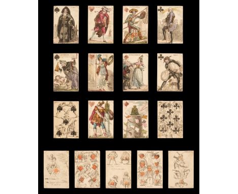
* French transformation playing cards. Cartes á Rire, Jeu des Journaux, Paris: Grandebes, circa 1819, 48 (of 52, without QC, A & 4 & KS) hand coloured engraved and captioned playing cards (French suits), designs attributed to Baron Louis Athalin, full-length courts representing Parisian newspapers, pip cards with humerous scenes, 7D probably added from another deck, dusty, somewhat soiled and marked, some stains, few (mainly corner) creases, 5D with closed 1cm ege tear, versos plain white, each card 90 x 61 mm, with original (very damaged) two-part box, label of A. Giroux & Cie, Paris to inner lip, together with: Belgian Animal Tarot, Ghent: J. De Porre, circa 1795, a shortened deck of 52 stencil coloured woodcut playing cards (French suits), comprising 12 courts (without caveliers) and 40 pip cards only (without trumps), single figure court cards, JS holding an armorial, JH with armorial and banner giving maker's details, some toning and spotting (mainly to pips), JH darkened and dusty, versos red dots and dotted flowers, each card 110 x 60 mm, plus: Spanish Archaic Pattern, Bayonne: Bernain (Antoine Joseph?), circa 1812, 36 (of 48, without 3, 4 & 5 of each suit) stencil coloured woodcut playing cards (Spanish suits), single figure courts, each stamped with 'France' and 'Bernain', some toning, courts and aces each with faint impression of a previous ownership signature, 7 of swords with some pale brown staining, versos plain white, each card 87 x 58 mm, and with another part pack: Theatrical playing cards, Strasbourg: Pflüger, circa 1850, 12 (of 52) hand coloured wood engraved playing cards (French suits), comprising all courts except QH and only one ace (diamonds), double-ended courts portraying named characters from theatre plays, each with central bar containing 'France Pflüger Strasbourg', the ace showing two scenes from 'Don Quichotte', lightly toned, corner chips and wear, JC with small stained surface abrasion to blank area, versos pale pink dotted swirls, each card 87 x 61 mm, a quantity of cards from each pack mounted with photo corners onto 5 display boards, encapsulated in clear plastic (none examined out of boards), the remainder in plastic bags, the boards 59 x 42 cm and similarQTY: (4)NOTE:Provenance: Collection of Dudley Ollis.First item: D'Allemagne, Les Cartes á Jouer... I, pp.260-264; Berry, Playing-Cards of the World [71] & [659]; British Museum 1896,0501.731.1-52 (Schreiber, French 97); Cary, FRA 325; Field #27; Morley pp.120-122; WWPCM00582.Second item: Mann, All Cards on the Table #221.
England & Wales. Rocque (John), England and Wales Drawn from the most accurate surveys, Containing all the Cities, Boroughs, Market Towns and Villages..., circa 1794, large engraved map with contemporary outline colouring on two sheets not conjoined, large cartouche with later hand-colouring, inset map of the Scilly Isles, old folds, slight offsetting and spotting, overall size 1200 x 985 mm, together with Kitchin (Thomas). A New Map of England & Wales Drawn from Several Surveys &c. on a new Projection Corrected from Astronomical Observations..., The Canals inserted to 1792 by J. Phillips Surveyor, Laurie & Whittle, 12th May 1794, large engraved map with contemporary outline colouring on two sheets not conjoined, inset map of the Scilly Isles, large uncoloured decorative cartouche, the cartouche incorporates a coastal scene with a ship, a soldier and a sailor and a spread of artefacts representing British trades, including sheep, wheat and cannonballs, compass rose and table of remarks, slight dust soiling, old folds, overall size if conjoined 1275 x 1090 mmQTY: (4)


Subbuteo Manchester United Set, circa 1999 Hasbro mint sealed condition, set 60140, with three teams,61158 Score board, 61102 goalkeeper, 61107 Linesman, 1 x Referee, 61205 3 x balls, 61139 trainers, 61214 14 x figures, 61131 two kickers, plus two sets of table rugby teams, all in good to mint condition.(11 items)

A boxed Bowman Jenkins Sailing Model of Sir Alec Rose’s Ketch ‘Lively Lady’ and a Sailor buoy game, 1970s, blue hard plastic hull and wood deck, red cockpit and hatches, tinplate rudder and original sails, 38cm (15”) long, good condition, side name plates probably not original, box with inner packing fair to good condition, some tears and wear, together with a Tri-ang Sailor Buoy table top Yacht racing game, very good complete condition with instructions, box good, (2 items).

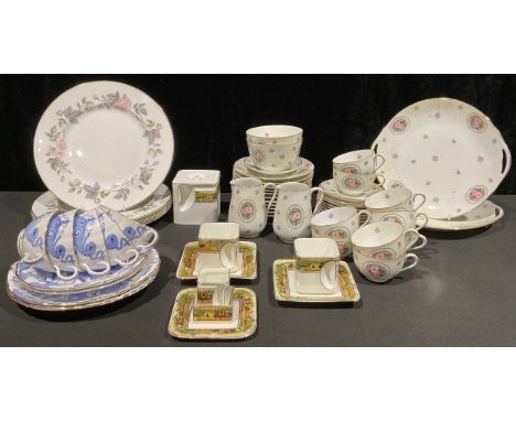
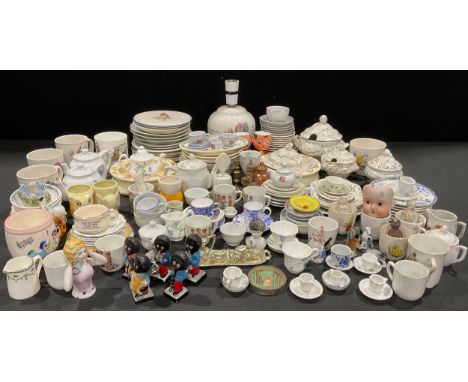
Nursery Ware - a Wedgwood of Etruria Beatrix Potter table lamp; other Beatrix Potter; Doulton Bunnykins baby plates; other nursery ware plates, cups, etc; a Victorian Staffordshire child's part dinner service; other child's part tea and dinner services; a Shelley miniature cup and saucer; Spode miniatures; porcelain dolls heads; etc, qty


ROYAL ALBERT; an approximately 135-piece 'Old Country Roses' pattern tea and dinner service to include eight large dinner plates, diameter 26.5cm, eight side plates, diameter 21cm, ten teacups, saucers and tea plates, ten soup bowls and saucers, lidded tureens, sandwich plates, teapot, milk, sugar, salt, pepper, napkins, cake server, oval plates, length 34cm, coffee pot, dessert bowls, gravy pot, telephone, gold plated teaspoons, mats, coasters, three large oval linen table cloths, eighteen serviettes, etc.

A collectors' lot comprising a Harley-Davidson Motor Cycles 2009 presentation set of five petrol tanks through the ages, case 24.5 x 39cm, a leather handbag in the form of a saddle, height 26cm, a modern whimsical table lamp in the form of a group of mushrooms with fairy, height 35cm, a small teddy bear, 16cm, a boxed Universal Studios 'ET', with tags, an Art Nouveau brass soap tray, 20cm, a Christmas 1980 'Rejoice' wall plaque by Jerrandie, limited edition no. 1540/4000, and a Swiss music box in the form of 'The Traveller's Rest' thatched tavern, plays 'Tavern In The Town' (8).Condition Report: -This lot is sold for decorative purposes only, and you must ensure that testing is completed by a qualified electrician before use.

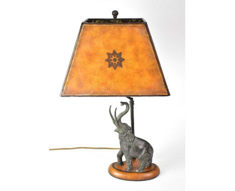
A figural table lamp with bronzed resin elephant figure raised on an oval plinth, height including fitment 59cm.Condition Report: - This lot is sold for decorative purposes only, and you must ensure that testing is completed by a qualified electrician before use.

-
1181390 item(s)/page