We found 297893 price guide item(s) matching your search
There are 297893 lots that match your search criteria. Subscribe now to get instant access to the full price guide service.
Click here to subscribe- List
- Grid
-
297893 item(s)/page


Lot 127
CF Porcelaine française Sèvres Suite de huit assiettes à feuilles de chou et trois assiettes à potage en porcelaine tendre à décor polychrome de bouquets de fleurs cernés de motifs de feuilles de chou rehaussés de peignés bleu et filet or, filet or sur les bords et motif de bouquet de fleurs au centre. Quatre assiettes sans marques et quatre assiettes marquées en bleu :LL entrelacés et lettres date N, Q, EE, et FF pour 1766, 1769, 1782 et 1783.Les trois assiettes à potage marquées R pour 1770 et diverses marques de peintres. XVIIIe siècle Diamètres : 24,4 cm et 23,5 cm Une assiette à feuilles de chou avec un éclat sur le bord, une assiette à potage avec une fêlure, une autre assiette à potage avec éclat sur le bord

Lot 132
CF Porcelaine française Sèvres Gobelet litron et sa soucoupe deuxième grandeur en porcelaine tendre à décor polychrome sur le gobelet d’un couple assis dans un paysage et sur la soucoupe de volière et cages dans un paysage dans des réserves cernées d’un filet or sur fond bleu céleste orné de guirlandes de feuillage retenues par des anneaux et rinceaux rocaille. Le gobelet marqué en bleu : LL entrelacés lettre date R pour 1770, marque de peintre K pour Charles Nicolas Dodin, la soucoupe marquée en bleu : LL entrelacés, lettre date effacée mais probablement FF pour 1783, marque de peintre illisible et marque de doreur pour Chauvaux. XVIIIe siècle, années 1770 et 1783 Hauteur : 7 cm Diamètre : 13,6 cm. La scène représentée sur le gobelet a pour source une gravure par Daullé d’après Boucher intitulée Les Amusemens de la Campagne faisant pendant à La Musique pastorale et annoncée au Mercure en décembre 1754 (Pierre Jean Richard, L’Œuvre gravé de François Boucher, 1978, no 555, p. 162 164). Sur la gravure des Amusemens de la Campagne, la corde que tient le jeune homme est reliée à une volière ici absente sur le gobelet mais représentée sur la soucoupe. Le décor de la soucoupe n’est donc pas sans lien avec celui du gobelet et il est fort probable qu’il reprend le décor de la soucoupe originelle. La même gravure a également été utilisée par Dodin pour la peinture d’un vase à bandes à fond bleu nouveau aujourd’hui dans les collections du duc de Buccleuch au château de Boughton.


Lot 558
RON KRAY: Oil on board, thickly applied paint, showing cottage beside tree and pond, signed R. Kray, the reverse inscribed Loury O`Leary, 13 1/2 x 10 1/2in, accompanied by handwritten letter from Ron to O`Leary stating `Thank you for comeing to see us. It was a very nice viset, and how good it was not to talk about crime. Please give our best wishes to Alf and Marc (Bolan) and would you tell Marc that I will do him a painting. He will have it soon (thought to be this one) and would you give Joe Bailey our best wishes, Well Loury thank you very much for comeing all this way to see us. It was nice to see you after so long. Loury in October we have done 5 and a half years. God Bless from Ron. Also accompanied by a photograph of Marc Bolan and Laurie O`Leary
Lot 113
Ensemble de 17 bouteilles 1 bouteille GEVREY-CHAMBERTIN Clair-Daü 19721 bouteille VIEUX MARC DE CHAMPAGNE Goyard (LB) 1 bouteille MEURSAULT Bouhey Allex 19712 bouteilles PINOT GRIS [1 de 1994, 1 de 1996] 1 bouteille MUSCAT R. Schofhit 1 bouteille PULIGNY-MONTRACHET Bouhey Allex 1969 (LB) 1 bouteille SAINT CHINIAN Caza Viel 19883 bouteilles HERMITAGE 1970 (blanc) 1 bouteille BEAUNE Delagrange 19731 bouteille BOURGOGNE (SE) 1 bouteille ANJOU Gamay 19822 bouteilles CHOUILLY Blanc de Blancs, 1 bouteille MEURSAULT Delagrange 1974


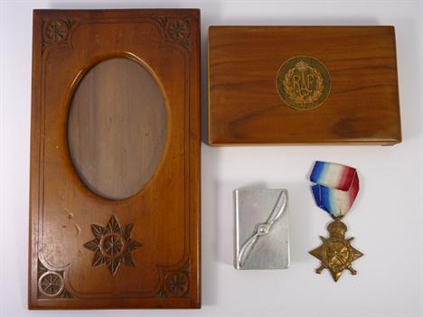
Lot 240
WW1 1914 start trio to W.H. Heagarty CPL 6487 1/Devon R together with volunteer long service and good conduct medal marked 5900 BNDMN W. Heagarty 1/Devon & Somerset Rev. Note: the victory medal is also misspelt `H Heggarty`. Together with discharge certificate showing enlistment as musician. Medal strip with silver rosette etc. Also together with WW1 pair to pte 465 W. Heagarty rifle brigade. From the family.


Lot 287
Astronomical Nautical Compass, c. 1860 Manufactured by: "Lilley & Son, London", brass, lithographed compass rose, graduation 4 x 90°, arc divided 0-150/150-0, circle divided 80-0-80, with embossed brass plaque "By her Majesty`s Royal Letters Patent, E. D. Ashe. R. N., Patentee", height 12 1/2 in. - Probably made for the Royal Society. Astronomisch nautischer Kompaß, um 1860 Hersteller: "Lilley & Son, London", Messing, lithographierte Windrose, Teilung 4 x 90 Grad, Winkelteilungen 0-150/150-0, Kreisteilung, 80-0-80, mit geprägter Plakette "By her Majesty`s Royal Letters Patent, E. D. Ashe. R. N., Patentee", Höhe: 32 cm. Eventuell hergestellt für die Royal Society. Condition: (2-3/3) Starting Price: €500

Lot 910
Steam Locomotive with Tender "Märklin" Gauge I No. R 3021 EB, high-voltage current, hand-painted locomotive, lithographed tender, overall length 16 1/6 in. Dampflokomotive mit Tender "Märklin" Spur I Nr. R 3021 EB, Starkstrom, handlackierte Lokomotive, Tender lithographiert, Gesamtlänge 41 cm. Condition: (3-4/-) Starting Price: €160


Lot 8
A Martin Brothers stoneware grotesque monk bird jar by Robert Wallace Martin, in typical form with blue and green mottled blue glazes, the removable head cover inscribed to the rim "R W Martin & Brothers London, Southall, 4.3.1911", the main body on a circular base inscribed "R W Martin & Brothers London, Southall, 4.3.1911" on an ebonised base, 23 cm high (ILLUSTRATED)

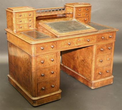
Lot 251
A Victorian walnut veneered desk in the manner of C & R Light, the top with central galleried shelf flanked by two chests, each with three quarter galleried top and moulded edge over three drawers with Wellington style locking mechanism, over a central writing slope with lidded stationery compartment opening to reveal a basic fitted interior with five pigeon holes flanked by two further tooled leather writing surfaces within a moulded edge over three frieze drawers with turned knob handles raised on two pedestals, each of three drawers with turned knob handles to plain plinth bases, left pedestal drawer stamped "Kerry, 545 New Oxford St", 123 cm wide (ILLUSTRATED)


Lot 103
Eastern North America (Map of the European Settlements in North America), Kitchin, A Philosophical and Political History…, London, ca. 1779. 9.5 x 12.5”. (HC) This map covers the eastern part of North America from Greenland to Florida with settlement confined to the eastern seaboard. Numerous Indian names are noted throughout. A comment by L. Ouinipigon alludes to a Northwest Passage: "R. of ye Assenpouels supposed to fall into the Western Ocean." The map is adorned with a garland style title cartouche and compass rose. This map appeared in both the 1779 and 1784 editions of Abbe Raynal`s A Philosophical and Political History of the Settlements and Trade of the Europeans in the East and West Indies. Ref: McCorkle no.779.9. Issued folding, now pressed with light offsetting. There is a binding trim at right, but still ample room for framing. (+B)

Lot 183
Western United States (Map of Upper California by the U.S.Ex.Ex. and Best Authorities 1841), Wilkes, Narrative of the United States Exploring Expedition, Washington D.C., 1841. 11.5 x 8.3”. (HC) This crisply drawn map covers all the American West south of 42 N. and west of the Rocky (Anahuac) Mountains, with by far the greatest detail in California. The cartography is distinctly pre-Fremont. The Sacramento and San Joaquin valleys combine to form the large Buenaventure Valley with the Rio San Buenaventura in the area of today`s Salinas River. The map pre-dates the discovery of gold by several years, but in the vicinity of Sutter`s mill where the settlement of New Helvetica is located. Along the coast the mission towns are named, but there is no mention here of Los Angeles even though it was a self-sustaining farming community as early as 1821. The Colorado River is shown trending in an oddly straight course giving no credit to the Grand Canyon. The Great Basin, called the Great Sandy Plain, is crossed by Smith`s Track and is bounded east and west by the Colorado Range and the California Range. The Great Salt Lake is Youta Lake and the Salt River is called the Inconstant R. Interesting notes explain the unknown qualities of the land and another describe the Indians as "the most miserable objects in creation," an unfortunate depiction. Ref: Wheat (TMW) no.458; Wheat (Gold) 23. Light offsetting with slightly uneven toning and an archivally repaired tear in top blank margin, far from map image. (+B)

Lot 201
Southwestern United States (Topographical Map of the Road from Fort Smith, Arks. to Santa Fe, N.M. and from Dona Ana N.M. to Fort Smith), Marcy, 31 Cong., 1st Sess, House Ex. Doc No. 45, Washington D.C., [1850]. 27.5 x 14.5”. (BW) This important map is bound in the original and complete report "Route from Fort Smith to Santa Fe. Letter from the Secretary of War" by Capt. R.B. Marcy, 5th U.S. Infantry, made by order of Bvt. Brig. Gen. M. Arbuckle. On the first page the report is forwarded by J.J. Abert, Col. Corps Top. Eng. to Hon. Geo. W. Crawford, Secretary of War and finally to the Hon. Howell Cobb, Speaker of the House of Representatives. This excellent topographical map delineates, for the first time, the region along the Red and Canadian Rivers. It shows two major roads from Fort Smith to Santa Fe, plus several other routes and Indian trails. The map also notes various tribal lands, topography and hydrology as well as the location of daily campsites. It is filled with interesting details and notations including the Apache Trail and Comanche Trail - "Said to be a good route for wagons, with water daily." It includes a very early depiction of Dallas located along the Trinity River. Wheat says "Marcy`s was the first comprehensive map of this area…" Disbound, 89pp, large folding map, and two plates by R. H. Kern, including "View of Santa Fe and Vicinity from the East." Ref: Howes S500, [map] Wheat TMW no.681. Light scattered foxing and toning along the folds. The pages are mostly clean with some scattered light foxing and a few stains on the title page. Map and report are housed in an attractive, contemporary brown clamshell folder. (+B)
![Houston & Galveston, Texas ([Views of Texas] Houston, Texas [On Sheet With] The Strans, or Main Street, Galveston, Texas](http://lot-images.atgmedia.com/SR/36385/2862480/312-2012510162829_468x382.jpg)
Lot 312
Houston & Galveston, Texas ([Views of Texas] Houston, Texas [On Sheet With] The Strans, or Main Street, Galveston, Texas [and] Galveston, Texas [and] Custom-House, Galveston, Texas), Harper`s Weekly, New York, 1866. 9.5 x 14.5”. (HC) This sheet includes four panoramic views of Houston and Galveston, Texas, all sketched by Theodore R. Davis for Harper`s Weekly. Originally published in the October 27, 1866 issue of Harper`s Weekly "A Journal of Civilization." English text on verso. Attractive color with a few spots of soiling and some short tears and cracks, two of which enter bottom images. The paper is a bit brittle. (+C)
-
297893 item(s)/page