We found 297893 price guide item(s) matching your search
There are 297893 lots that match your search criteria. Subscribe now to get instant access to the full price guide service.
Click here to subscribe- List
- Grid
-
297893 item(s)/page


Lot 200
Queen's South Africa 1899-1902, three clasps (2), Cape Colony, Transvaal, Wittebergen (4216 Pte. R. McGrath, 2nd Rl. W. Kent Regt); Cape Colony, Orange Free State, Transvaal (4730 Sgt. J.C. Mitchell, 2nd Rl. W. Kent Regt), first toned, good very fine, second suspension claw re-pinned, very fine (2) Subject to 20% VAT on Buyer’s Premium. For more information please view Terms and Conditions for Buyers.


Lot 210
Army Long Service & G.C., E.VII.R. (2) (1504 Pte. G. Humphreys. Rl. W. Kent Regt; 4730 Sjt: Mr: Tlr: J. Mitchell. Rl. W. Kent Regt), suspension claw re-pinned on latter, generally very fine or betterTerritorial Force Efficiency Medal, G.V.R. (68 C.Q.M. Sjt. E.G. Field. 5-R.W.Kent R), very fine (3) Subject to 20% VAT on Buyer’s Premium. For more information please view Terms and Conditions for Buyers.

Lot 211
Army Long Service & G.C. (3), G.V.R., 1st 'Field Marshal's bust' type (2) (4493 Pte. W. Cridland. R. W. Kent Regt; 6188485 Sjt. E. Hill. R.W. Kent Regt); G.VI.R., with 'Regular Army' bar suspension (6338044 Sjt. J.D. Parks. R.W. Kent. R.), last with official corrections, generally very fine (3) Subject to 20% VAT on Buyer’s Premium. For more information please view Terms and Conditions for Buyers.

Lot 218
Pair: Police Constable W. Allen, Metropolitan PoliceJubilee 1887, with 1897 Bar (PC. W. Allen. R. Divn.); Coronation 1902, bronze (P.C.. W. Allen. R. Div.), nearly very fineJubilee (Metropolitan Police) 1887, with 1897 Bar (PC. W. Brown. T. Divn.), good fineJubilee (City of London Police) 1887, with 1897 Bar (PC, 930. C. Clinkscales.), edge bruise, nearly very fine (4) Subject to 20% VAT on Buyer’s Premium. For more information please view Terms and Conditions for Buyers.

Lot 667
A gentleman's Heuer Chronosplit LCD Ferrari stainless steel wristwatch, on a stainless steel Heuer strap, boxed with limited warranty See illustration Condition report Report by MW The watch is from a private source, a deceased estate, who was a prominent figure in the Ferrari Owners Club UK. The watch is currently not working, the crystal with the Ferrari insignia has two very large and deep scratches on it. The case has several scratches and marks of general use. The integral stainless steel bracelet has several scratches and marks of general use. The links are quite tight. The back engraved, assembled in Switzerland, quartz solid state, R.100.703-3, 331109, complete with box and operating instructions and warranty booklet.

Lot 753
A Lalique clear and opalescent glass Volutes pattern bowl, etched R Lalique France, 20.5 cm diameter See illustration Condition report Report by NG Some production faults are visible including bubbles and pitting, also a seam/fold visible in base. Some surface scratches and wear. Inside centre stencilled R LALIQUE FRANCE

Lot 754
A Lalique clear and opalescent glass Volutes pattern plate, etched R Lalique France, 28 cm diameter See illustration Condition report Report by NG Some manufacturing faults, including pitting and bubbles. Also brown mark visible in the centre of the plate which is in the glass. Stencilled R LALIQUE FRANCE marked to centre. Some surface scratches and wear.


Lot 206
Map of Passes in the Sierra Nevada from Walker`s Pass to the Coast Range: from Explorations and Surveys Made Under the Direction of the Hon. Jefferson Davis Secretary of War... This detailed map of the region centers on Tejon Pass, including the Tulare Valley, and the Kern and Buenavista Lakes. Walker`s Pass, Hum-pah-map Pass, Tah-ee-chay-pay Pass, Tejon Pass, Arroyo de las Uvas, Arroyo de San Arminio, and Fremont`s route through the region are located. A wagon road through Tejon Pass and a new pass leading to Los Angeles are also identified, and topography is denoted through finely engraved hachure. Issued folding, now pressed, with very light toning along a few folds and a couple of small spots. Backed in Japanese tissue to repair several short fold separations. 30.5"" W x 20.1"" H Williamson, R. S. (Lt.) 1853
Lot 314
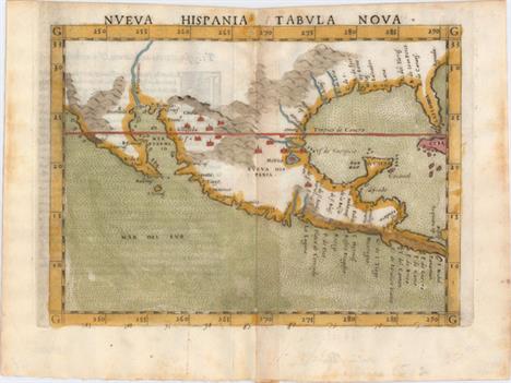
Nueva Hispania Tabula Nova This is a foundation map in the cartography of the American Southwest, and a must for collectors of that region. It is an enlarged version of Gastaldi`s map of 1548 with the only notable change being the peninsular Yucatan. The legendary seven cities of Ciuola are prominently depicted and Mexico City is shown floating in a large lake. The place names along the upper Gulf Coast reveal the explorations of Pineda, Cabeza de Vaca and Moscosso. The Mississippi makes its appearance as the Rio de Spiritu Santo and the R. Tontonteanc flows in the vicinity of the Colorado River. Considered the earliest relatively obtainable map of Mexico and the American Southwest. This is the first state according to Burden. Latin text on verso.See also lot 737 for the first edition of Ruscelli`s atlas, La Geografia de Claudio Tolomeo Allessadrino A dark impression on watermarked paper with faint offsetting, light text show-through, and minor toning along centerfold. 7.3"" W x 9.5"" H Ruscelli, Girolamo 1564

Lot 315
Hispania Nova This is one of the earliest maps of the American Southwest and Mexico, including the southern part of present-day Texas, here called Floridae Pars, with the Rio Grande, labeled R. de Palmas. The map concentrates on the Spanish area of influence and is one of nineteen regional maps of the Americas contained in Wytfliet`s atlas, which was the first devoted exclusively to the New World. Stipple engraved seas, calligraphy and a decorative title cartouche adorn the map. Fine impression and color on watermarked paper with two soft creases and light printer`s ink residue. 9"" W x 11.3"" H Wytfliet, Cornelis 1598

Lot 318
Spanish Dominions in North America An uncommon map by Arrowsmith that shows an oddly shaped western coast of Mexico, names the town of Texas on the Rio Colorado or Cannes R, locates the fictional Quivira, and much more. This copper engraved map further shows numerous place names, provinces, topography, missions, towns, forts and Indian tribes. The relief is shown by hachure and the seas are fully engraved with closely placed ruled lines. A simple title cartouche floats in the lower left. A rarely offered and desirable map of the Southwest. Light damp stains at left and bottom right with a worm track in the bottom right corner of the sheet, away from map image. 8"" W x 9.5"" H Arrowsmith & Lewis, 1804

Lot 326
Audience de Guadalajara Nouveau Mexique, Californie, &c. This map was first published in 1656 and introduced the so-called second Sanson model of California as an island. This depiction shows a small peninsula (Agubela de Cato) above the island, two bays along the island`s northern coast and two new place names, Tolaago and R. de Estiete. Sanson actually based this on information from the less well known map by Luke Foxe, but it was this map that influenced many other cartographers throughout the rest of the century. On the mainland there are new Indian tribes identified in the region of the R. del Norte, which flows southwest from a large inland lake. The map was re-engraved for this edition, with only very minor differences from Sanson`s map of 1657. This is the second state of the Ribbius edition, with the addition of a grid of longitude and latitude. A dark impression, issued folding, with minor printer`s ink residue and a professionally repaired tear confined to right blank margin. 8"" W x 9.4"" H Sanson, Nicolas 1700

Lot 329
Central America II. Including Texas, California and the Northern States of Mexico This excellent map covers the southwestern United States just a few years before Mexico lost the region in the Mexican-American War. Texas is shown as an Independent Republic with its panhandle extending well north up to Spanish Peaks. Excellent detail throughout Texas shows many towns and villages, roads and trails, topography, and watershed. All of the Southwest and California are here noted as ""Generally called Upper California."" Large swamps and lakes in the Great Basin drain through a complex R. Buenaventura system. The map displays excellent detail throughout and includes many frontier forts, Indian tribes, etc. There are interesting notations; a Supposed Petrified Forest in the western part of Texas, Supposed residence of the Aztecs in 12th century (Humboldt ) in the Moquis (Hopi) region of present-day Arizona. Published by Chapman and Hall, engraved by J. & C. Walker. Dated 15 Oct. 1842. A nice example with a hint of toning and one small chip in the top right corner of the sheet, away from map image. 12.2"" W x 15.5"" H SDUK Society for the Diffusion of Useful Knowledge, 1842

Lot 358
A New and Correct Large Draught of the Tradeing Part of the West Indies This two-sheet map of the Gulf of Mexico and Caribbean gives excellent detail along the coastlines. The map extends north just past the May River in present-day South Carolina. Southern Florida is depicted as a series of large islands, with a prominent R. Dais extending to the northwest. A large river and delta located where the Mississippi River should be is left unnamed, with the huge Carlile Island located at the mouth. Instead, theR. Messisepy and B. de Spirito Sancto is erroneously labeled in the area of Galveston Bay.Place names, soundings, rocks, shoals, and anchorages are identified throughout. A dotted line along the shore of the Bay of Mexico and along the eastern coast of Nicaragua indicates the area within which soundings have been measured. The map is embellished with two compass roses and three sailing ships. This map appeared in the pirated edition of The English Pilot, published by George Grierson in 1749 and by his son, Boulter Grierson, in 1767.This map is extremely scarce. We have found only two examples of it being offered for sale in the last 35 years, one of which was still bound in the atlas. A nice impression with light printer`s ink residue on the western sheet. Issued folding, now pressed with very minor archival repairs along the folds. 20.1"" W x 32.8"" H Thornton, Samuel 1749

Lot 386
America Meridionalis Superb folio map of the continent that was added by Jodocus Hondius for publication in his continuation of the Mercator Atlas. The interior features the large mythical Parime Lacus straddling the equator and an equally interesting river system. The huge Rio de la Plata flows south from the conjectural Eupana Lacus in Brazil, while the R. Grande flows north from the same lake to join the Amazon River. The Strait of Magellan is shown, but Tierra del Fuego is part of the large southern continent. The map is beautifully engraved with a wave pattern in the oceans, which are filled with ships, sea monsters and a native canoe. The continent is flanked by two elaborate cartouches; title to the right and a large inset plan of Cuzco incorporated into the distance scale cartouche on the left. A Native American is seen with a bow and arrow in the interior. Latin text on verso. A clean and bright example with a nice impression. There are expert repairs to several separations along the centerfold. 14.1"" W x 19.4"" H Hondius, Jodocus 1623

Lot 612
Ierusalem Comme Elle Est a Present This lovely, uncommon view of modern Jerusalem by Pierre R. Aveline is drawn after Matthaus Merian. It shows the city from the east, with a vantage in front of the sealed Golden Gate. In the foreground there are numerous individuals in contemporary dress moving toward the city. A key running along the bottom of the view identifies 36 places of interest, with an additional note pointing out that Jerusalem means ""Vision of Peace"" or ""Perfect Vision"". Among the places listed are the Church of the Holy Sepulchre, the Tomb of Absalom, and the Ecce Homo arch (called here Arc de Pilate) above Via Dolorosa, the road Jesus walked while hoisting the cross on which he was to be crucified. The Dome of the Rock is prominently displayed, although it is here referred to as Temple de Salomon. Although there has been no compelling archeological evidence that Solomon`s Temple existed, it is said to have been located on Temple Mount. For instance, during the Crusades the Knights Templar believed that the Dome of the Rock was the site of Solomon`s Temple. A nice impression with light soiling and a number of small abrasions. There are a number of short tears that have been professionally repaired with tiny portions of the image missing. 12.8"" W x 20.7"" H Merian, Matthaus 1700

Lot 648
To James Carnegy and R. Scott Esqrs. Of Prince of Wales Island as a Tribute Due for Their Valuable Communications ... This Chart of the Islands and Channels at the Southwest Extremity of the China Sea... This large sea chart of the South China Sea shows Singapore and the islands to its south. The chart is dense with detail and spans from the southern tip of the Malay Peninsula through the Singapore Strait down to Pulau Singkep and stretches east past the Bangka Strait. Depth soundings, rocks, notes on navigation and exploration, channels, banks, shoals, compasses, and hundreds of islands are shown. Several small views are included, illustrating various peaks from the vantage of the sea. Originally published in December 1821 with corrections up to 1850. Engraved by John Bateman. On a slightly toned sheet with small light damp stains and scattered foxing. There are numerous small chips and short edge tears confined to the blank margins, a few of which have been closed on verso with archival tape. 37.6"" W x 24.9"" H Horsburgh, James (Capt) 1850

Lot 667
An Accurate Map of the East Indies, from the Latest Improvements and Regulated by Astronomical Observations This decorative small map, with a rococo-style title cartouche and compass rose, extends from Persia to Indochina and south to include most of Sumatra and the corner of Borneo. It provides a good depiction of the Maldives, Ceylon, and the islands in the Indian Ocean with several of the smaller islands named. At the top of the map is the Coby or Sandy Desert, north of the Kingdom of Tibet. Engraved by R. Reynolds. A nice impression with a few miniscule pinholes only visible when held to light. 7.8"" W x 11.5"" H 1773

Lot 737
La Geografia di Claudio Tolomeo Alessandrino, Nuovamente Tradotta di Greco in Italiano... This is the first edition of Girolamo Ruscelli`s translation of Claudius Ptolemy`s Geographia, published in Italian. It was printed by Vincenzo Valgrisi in Venice, with the text translated from Greek by Ruscelli. It is complete with 62 maps; 25 classic and 37 modern, which are enlarged copies of the maps created by Giacomo Gastaldi for his 1548 edition of Ptolemy. These maps demonstrate the amazing advances in geographic knowledge taking place in this great era of exploration. They are from finely engraved copper plates, which were a great improvement over the rather crude woodcut maps in many of the earlier editions. The maps were engraved two to a plate, then printed and separated for binding, which is why the plate mark for each map runs off the top edge of the page. The classic maps include a conical projection of the world, 10 maps of Europe, 4 of Africa, and 12 of Asia. The modern maps include two world maps, 17 maps of Europe, 5 of Africa, 6 of Asia, and 7 maps of the Americas.Orbis Descriptio is the first double-hemisphere world map to appear in atlas form. It is elegantly engraved in the characteristic Italian style, adapted from the oval projection used by Gastaldi, and presented on what is known as Roger Bacon`s circular projection. This projection was popularized by Ruscelli and later by Rumold Mercator. Another important feature of the map is the apocryphal bulge in South America; one of the most copied cartographic errors of the 16th century. Terra Incognita is distinctly shown as a land bridge linking Asia and North America with its coastline labeled Littus incognitum. This is the first state with no southern continent.Ruscelli`s important early map devoted to the East Coast of North America, Tierra Nueva, is based on Giacomo Gastaldi`s map of 1548, which combined data from the Verrazano and Cartier voyages. The cartography is unchanged, with the exception of the depiction of the Hudson and St. Lawrence Rivers (unnamed), which are shown connected upriver, a notion he borrowed from Ramusio. Engraved on copper by Giulio and Livio Sanuto in the unmistakable Italian style.Also included is Nueva Hispania Tabula Nova, a foundation map in the cartography of the American Southwest, and a must for collectors of that region. It is an enlarged version of Gastaldi`s map of 1548 with the only notable change being the peninsular Yucatan. The legendary seven cities of Ciuola are prominently depicted and Mexico City is shown floating in a large lake. The place names along the upper Gulf Coast reveal the explorations of Pineda, Cabeza de Vaca and Moscosso. The Mississippi makes its appearance as the Rio de Spiritu Santo and the R. Tontonteanc flows in the vicinity of the Colorado River.Complete, 358 pages, 62 maps, and index. Bound with the 47-page Discorso Universale de M. Gioseppe Moleto Matematico.... Original vellum binding with brown ink manuscript title on spine. The text and maps are bright with light foxing and a faint damp stain at top right, entering up to 1"" into some maps. Most of the maps are in very good to near fine condition, with a few only in good condition. The first 40 pages of text also have a damp stain along the spine. There are some manuscript notations and a previous owner`s stamp on the title page. The hinges are starting and the covers show some wear with a few small worm tracks. 9.3"" W x 6.4"" H Ptolemy/Ruscelli & Valgrisi, 1561

Lot 769
Facsimile-Atlas to the Early History of Cartography with Reproductions of the Most Important Maps Printed in the XV and XVI Centuries This is a reprint of Nordenskiold`s highly important and useful work, which was the first systematic approach to the study of cartographic history. Translated by Johan Adolf Ekelof and Clements R. Markham with a new introduction written by J. B. Post and a glossary of cities. Reproduces 169 of the most important maps printed before 1600, including the complete 1400 edition of Ptolemy. This is a wonderful reference atlas of significant maps. 141 pp., plus 102 plates. Soft pictorial covers. Minor shelf wear and sunned spine. 16"" W x 11"" H Nordenskiold, Nils Adolf E. 1973

Lot 51
Americae Sive Novi Orbis, Nova Descriptio This is one of the most famous maps of America and one that had enormous influence on the future cartography of the New World. Frans Hogenberg engraved this map and it is primarily based on Gerard Mercator`s great multi-sheet world map of 1569. The map features an exaggerated breadth of the North American continent, with a lengthy St. Lawrence River reaching across the continent to nearly meet the fictitious, westward flowing Tiguas Rio. The strategically placed title cartouche hides the unknown South Pacific and therefore most of the conjectural great southern continent, which is shown attached to both New Guinea and Tierra del Fuego.This is the third of the plates that Ortelius used of the Americas, evidenced by the removal of the bulge on the southwestern coast of South America and an added cartouche in North America. Also on this plate, the Solomon Islands are noted for the first time since their discovery in 1568, and the names California, R. de los estrechos, and C. Mendocino have been added to the west coast of North America. The native name of Wingandekoa has been added to the eastern coast, originating from an unsuccessful attempt to colonize the Outer Banks by the English. Dutch text on verso, published in 1598, 1610, and 1613 with identical versos. A strong impression with superb original color on watermarked paper. There is very light soiling and professional repairs to a tiny hole along the centerfold and a short centerfold separation confined to the top blank margin. 14"" W x 19.1"" H Ortelius, Abraham 1587

Lot 70
Americque Septentrionale par N. Sanson d`Abbeville Geographe du Roy This is a charming little map of North America with California as an island embellished with a strapwork title cartouche. California is shown with an indented northern coastline in the Foxe form. The detached coastline to the northwest of California is named Terre de Iesso, rather than reflecting Sanson`s earlier belief that it was an extension of the American continent. The R. de Nort drains into the Gulf of California from a large interior lake in the country of Les Apaches. The two western-most Great Lakes are left open-ended and Lake Erie remains unnamed. Engraved by A. d`Winter. This is the second state with a peninsula inserted northeast of California, the Carolinas attributed to the French, and N. Iork added below N. Amstredam. A dark impression on watermarked paper. Issued folding with light soiling and a professionally repaired tear in bottom blank margin. 7.8"" W x 10.9"" H Sanson, Nicolas 1700

Lot 86
North America Detailed and finely engraved map that portrays an Independent Texas, with Mexico controlling Nueva California. The boundary between Canada and the United States is left unengraved, leaving the ownership of Oregon Territory (here labeled Columbia) unknown, which is unusual for a British map. Filled with well-developed topography, the map names numerous forts, trading posts, Indian tribes and locates L. Youla roughly near the Great Salt Lake with the American Fur Depot on its eastern shore. The R. Buenaventura extends to the Pacific from two branches, one originating from a large swamp in the Great Basin. The course of the Snake River is fairly accurate, but the Colorado River originates too far north and rushes to the Sea of Cortez in a straight line. Locates the 3 buttes in present-day Idaho -- important landmarks on the Oregon Trail. Lake Michigan retains its erroneous elongated shape. Distance scales outside of border give English Miles and Spanish Leagues. Engraved by J. & C. Walker and published by Chapman & Hall. Original outline color with just a hint of toning along edges of sheet. 15"" W x 12"" H SDUK Society for the Diffusion of Useful Knowledge, 1843

Lot 91
The Isle of California. New Mexico. Louisiane. The River Misisipi. And the Lake`s of Canada. Herman Moll`s map of the island of California and the western part of North America combines a lot of information with quite a bit of nonsense. Just north of California is The North Straits that separate the island from Agubela de Cato and the Land of Panimaha. Further north lies the Straits of Annian and the partial coastline of Annian. Four major rivers flow west into the Gulf of California with The 7 Cittys near the mouth of the Coral R., just west of Acoma. Conibas Lake forms the source of the North or Bravo R. (Rio Grande), which correctly empties into the Gulf of Mexico. Much of the map appears to have been derived from Hennepin, but it contains vastly more detail and the locations of numerous Indian villages, including the Missourits on the bank of what would become the Missouri River. Several forts are shown along the Mississippi River and in the Great Lakes region. In Canada, the Mission des Recolets is located just south of the Lake of Assinibouels, and is noted as ye Farthermost in ye whole Country. Another interesting notation shows a tree, near the headwaters of the Mississippi, into which the Arms of France are cut. On a full sheet of English text measuring 8.4 x 12.3"". A fine, dark impression with one small spot. 6.4"" W x 7.3"" H Moll, Herman 1701
![[On 2 Sheets] A Map of Louisiana and Mexico / Carte de la Louisiane et du Mexique This highly detailed large-scale map of we](http://lot-images.atgmedia.com/SR/36385/2916721/94-2014116145415_468x382.jpg)
Lot 94
[On 2 Sheets] A Map of Louisiana and Mexico / Carte de la Louisiane et du Mexique This highly detailed large-scale map of western North America extends north to Queen Charlotte Sound and James Bay in Canada, east just past the Mississippi River, and south to Guatemala. The map depicts the U.S. just after the settlement of its boundary with Mexico in 1819. The Adams-Onis Treaty, or Transcontinental Treaty, of 1819 was critical in defining the U.S.-Mexico boundary. In the provisions of the treaty, the U.S. ceded to Spain its claims to Texas, New Mexico and California in exchange for Spain`s claims to east Florida and the Oregon Country north of the 42nd parallel (the present-day northern border of California). This map shows the new boundary between the U.S. and Mexico, and leaves the boundary between the U.S. and Canada open to the west, reflecting the joint interests in the area between the Americans and British.There is incredible topographical detail of the Rocky Mountains, and the extensive network of rivers in the U.S. is also well defined. Towns and early roads are also identified. California and Nevada are left blank with the exception of the R. del Carmelo o S. Felipe connecting the Pacific Ocean to L. Teguayo. Both L. Teguayo and nearby L. Timpanogos are noted as ""doubtful."" U.S. state boundaries are identified east of the Mississippi River, including the Northwest Territory, encompassing Wisconsin and parts of Minnesota. To the west of the Mississippi River is the enormous Louisiana, which is divided into the state of Louisiana, Arkansas Territory, and Missouri Territory with an undefined western border. Present-day Texas is divided into several Mexican provinces with only a few towns noted (including S. Antonio) and one long trail crossing the state. The Red River is illustrated dipping too far south.A note at bottom explains the cartographical sources for the map. Upper Louisiana was based on the work of Pike and Lewis and Clark, while the state of Louisiana was based on the work of William Darby. Arkansas Territory and the Province of Texas were derived from John Melish`s map of the United States. Several other cartographers are also noted, including Alexander von Humboldt and Aaron Arrowsmith.This map was published for distribution in Paris by J. Goujon and in New York by Anthony Girard. On two sheets. If joined, the map would measure approximately 31"" x 43"". A bright, clean example with original color and just a few tiny spots of foxing. Trimmed to neatlines at sides. Please note that the image of the map as a whole is a composite image - the 2 sheets are not joined. 20.9"" W x 31"" H Tardieu, Pierre Antoine 1820

Lot 103
Carte des Parties Nord et Ouest de l`Amerique Dressee d`Apres les Relations les Plus Authentiques par M... en 1764 Robert de Vaugondy`s rendition of Samuel Engel`s map of 1764 alters the North American coastline slightly and extends to include part of Asia. The myth of a Northwest Passage continues to persist, here linking the Detroit d Anian with Lac Michinipi by a system of rivers and a large Lac des Conibas. There is also a River of the West that connects to another large lake, L. des Tahuglanuks that is located near a remnant of Lanhotan`s R. Longue. Alaska is shown as a series of large islands. California is labeled Grand Quivira. A great map that illustrates many of the cartographic myths of the period.See also lot 766 for Portinaro and Knirsch`s excellent reference work, which describes this map. A clean and bright example with a dark impression on watermarked paper and a couple of minute worm holes. Issued folding with a binding trim at left that has been replaced with old paper. Narrow bottom margin. 11.8"" W x 15.2"" H Robert de Vaugondy, Didier 1772

Lot 111
A Map of New France Containing Canada, Louisiana &c. in Nth. America... This interesting map depicts the French possessions in North America in the early part of the eighteenth century. New France included Canada and the proprietary colony of Louisiana, which included the former Spanish possessions in Florida. In 1712, King Louis XIV selected Antoine Crozat, the Marquis de Chatel, as the proprietor for Louisiana. Crozat was granted a monopoly on trade for fifteen years, but failed to develop the colony and relinquished his rights in 1717. The map is filled with information including colonial settlements, Indian villages, and forts. The British colonies are confined east of the Appalachian Mountains. The Great Lakes are presented in a strange format and La Hontan`s R. Longue is shown in the upper left. The route of the Spanish treasure fleet is shown in the Gulf of Mexico and around the tip of Florida. Published in London in Thomas Salmon`s Modern History: or the Present State of All Nations. A superb impression on watermarked paper with scattered foxing confined to the blank margins. 7.2"" W x 10.2"" H Moll, Herman 1745

Lot 176
Countries Bordering on the Mississippi and Missouri This rarity is an early map detailing the heart of the United States, from the region of present-day North Dakota to Lake Erie in the north, and from San Antonio to the Georgia and Florida coast in the south. The boundaries and internal political divisions of Arkansas and Missouri are unique to this map. Their western boundary is defined by the ""Osage Boundary"" shown at 94°W longitude. Arkansas contains two districts, namely Arkansas and Lawrence, and Missouri contains Cape Girardeau, St. Louis and Howard districts. To the west is an immense Missouri Territory which in turn incorporates a large but ill-defined Dewalieierres Grant with no mention of Texas or Cenis. Chicago is on the shore of Lake Michigan in Illinois Territory, but is shown many miles south of its correct position. The ""Extended [Indian] Boundary by various Treaties"" wanders through Indiana and Ohio and is loosely associated with the north-south Osage Boundary. In the area of Texas, the outward and homeward routes for Pike`s expedition are delineated, many forts are named, and the Haywa Wanderings and the Haytones Wandering Grounds are located. Early wagon roads and trails noted, as are early towns and cities as far north as Cleveland. Imprint below neatline ""Published Jany. 15, 1821 by Sir Richd. Phillips & Co. London."" The map is bound it the original ""Journal of a Tour into the Interior of Missouri and Arkansas, from Potosi, or Mine a Burton, in Missouri Territory, in a South-West Direction, toward the Rocky Mountains; Performed in the years 1818 and 1819"" by Henry R. Schoolcraft, Printed for Sir Richard Phillips and Co., London. This is Schoolcraft`s log detailing his remarkable 90-day expedition. Without covers, 102 pp, large folding engraved map present. Also includes 26 pp. of text at the end entitled ""Voyage from France to Cochin-China."" The map has faint offsetting, minor soiling, and a 3"" binding tear closed on verso with old paper. Disbound text is mostly clean with about half of the pages dog-eared in the bottom corner. 12"" W x 14.5"" H Schoolcraft, H. 1821

Lot 187
Map of Upper California by the U.S. Ex. Ex. and Best Authorities This crisply drawn map covers all the American West south of 42 ° N. and west of the Rocky (Anahuac) Mountains, with by far the greatest detail in California. The cartography is distinctly pre-Fremont. The Sacramento and San Joaquin valleys combine to form the large Buenaventure Valley with the Rio San Buenaventura in the area of today`s Salinas River. The map pre-dates the discovery of gold by several years, but in the vicinity of Sutter`s mill the settlement of New Helvetica is located. Along the coast the mission towns are named, but there is no mention here of Los Angeles even though it was a self-sustaining farming community as early as 1821. The Colorado River is shown trending in an oddly straight course giving no credit to the Grand Canyon. The Great Basin, called the Great Sandy Plain, is crossed by Smith`s Track and is bounded east and west by the Colorado Range and the California Range. The Great Salt Lake is Youta Lake and the Salt River is called the Inconstant R. Interesting notes explain the unknown qualities of the land and another describe the Indians as ""the most miserable objects in creation,"" an unfortunate depiction. A crisp impression with faint offsetting and minor toning along sheet edges. 8.4"" W x 11.4"" H Wilkes, Charles 1841

Lot 192
Milk R. to the Crossing of the Columbia R. from Explorations & Surveys Made Under the Direction of Hon. Jefferson Davis, Secretary of War Remarkable map that details the 1853-55 surveys conducted to locate a northern route (47th and 49th Parallels) on an expedition led by Isaac Stevens, Governor of Washington Territory. Most of the map covers Montana, with extraordinary detail and excellent relief by hachure, the naming of rivers, numerous routes with dates, and interesting topographical commentary. The map not only shows the main party`s route, but also numerous routes followed by the various parties attached to the command. Printed on three sheets, joined as issued. It is dated 1853-55, but was published in 1860. Issued folding. There are two holes that have been infilled with paper with a minute amount of image missing, a few light stains, and light toning especially concentrated along the top of the sheets. Several short fold separations and edge tears appear in the blank margins. 23.5"" W x 60.9"" H U.S. Railroad Surveys, 1853-55


Lot 147
A group of four World War I medals including The British War Medal, The Victory Medal, The 1914-15 Star and the Mercantile Marine medal issued to 2543 Pte. E. Attwood, Monmouth R. and ephemera, a 9ct yellow gold masonic jewel with enamel decoration for the Morganwg Lodge, a 9ct gold bar brooch, Stewards jewels, and a white metal belt


Lot 393
A Swansea six lobed creamware dish with a chocolate edge hand painted with a botanical scene possibly by Thomas Pardoe, painted to the reverse `Alpine Soldanella` impressed mark, 18.5cm diameter together with another similar dish painted with poppies and cornflowers impressed mark, collection label for Gwyneth and Ieuan R Evans no.1043


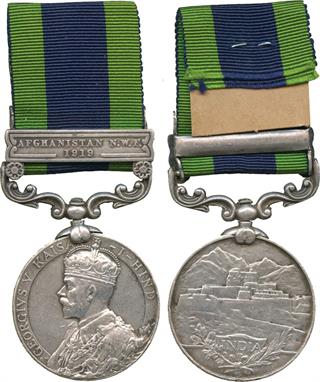
Lot 100
MILITARY MEDALS, A Fascinating IGSM and RAF Long Service Pair awarded to Trumpet Major Albert Horace ‘Ime’ Imeson, Royal Air Force Central Band, late Derbyshire Yeomanry and 4th Dragoon Guards, he was later wounded at Gallipoli in 1915, and later became the RAF’s first official Trumpet Major, playing at St Paul’s Cathedral 10 October 1930 to the victims of the R101 airship disaster, and numerous times at the Cenotaph, comprising: India General Service Medal, 1895-1902, single clasp, Punjab Frontier 1897-98 (4032 Pte A. Imeson 4th Dragoon Gds.), Royal Air Force Long Service Medal, GVR (402169 Sjt. A. H. Imeson. R.A.F); the first officially engraved in a running script, the second officially impressed, pair loose. Lightly toned, and polished as can be expected for a long service soldier, with a few tiny marks and nicks in places. Proudly worn, fair. Trumpet Major Albert Albert Horace Imeson enlisted as a Trumpeter Private in the 4th Dragoon Guards at the age of 14, later serving during the Punjab campaign of 1897-98. On completion of 12 years’ service he was living in Derbyshire and enlisted into the Derbyshire Yeomanry in the Great War and was severely wounded at Gallipoli in 1915. Presumably as a result of his wounds he transferred to the Royal Flying Corps. Awarded his RAF LS&GC Medal in 1920 in 1922 Imeson was appointed the first official Trumpet-Major in the Royal Air Force. From this period until his retirement in 1931 he taught recruits to play the bugle and trumpet. Annually he would train and lead the trumpeters at the Armistice Day Cenotaph ceremony and played at the memorial service at St. Paul’s Cathedral on 10 October 1930 to the victims of the R.101 disaster. On reaching 55 years’ service he was discharged to a pension on 28 October 1931 on completion of 29 years and 110 days regular service. Four years later he died, aged 59, at his home, Casella, Hercies Road, Hillingdon, Middlesex. In his obituary published in the Daily Express it stated: ‘Last Post will be sounded on Wednesday over the grave of the man who has sounded the same call every Armistice Day for the past seven years at the Cenotaph in Whitehall. He was Trumpet-Major A. H. Imeson, late of the Royal Irish Dragoons, who died yesterday at Hillingdon, Middlesex, aged fifty-nine. The hill passes of India heard his trumpet, and it rang on the battlefields of Gallipoli, where he was wounded in action. Millions throughout the world have heard its notes broadcast on Armistice Day.’ A further more detailed obituary was published in a Tasmanian newspaper, The Mercury, it read: Trumpet-Major Albert H. Imeson, the finest trumpeter the Royal Air Force has ever known has died at his home in Hillingdon, near Uxbridge. Thousands of airmen new “Ime”. For years he was one of the most popular figures in the training depot at Uxbridge. For seven years he was called upon to train and lead the trumpeters at the Armistice Cenotaph service in London. At all the big Royal Air Force ceremonial parades, including the funeral of the R.101 victims, he had charge of the trumpeters sounding “The Last Post.” “Ime” taught hundreds of men how to blow a trumpet and bugle. His whole life was devoted to “calls”. At the age of 14 he joined the Dragoon Guards as a trumpeter and served in India for 12 years. During the war he was severely wounded at Gallipoli. Later he transferred to the Royal Air Force, and was appointed trumpet-major of the band. Just before he was due to be discharged on pension he said, “It will kill me if I leave the service. I can never go on without my trumpet.” As a civilian he “haunted” the Royal Air Force depot at Uxbridge. He refused to leave the district, living only a short distance from the camp gates. Now he has died at the age of 59 – died, his friends say, of a broken heart. At his funeral on the 2 October 1935 The R.A.F.

Lot 115
MILITARY MEDALS, A Second Boer War and WWI LSGC Group of 6 awarded to Battery Sergeant Major Richard J Dellbridge, 14th Brigade, Royal Field Artillery, comprising: Queen’s South Africa Medal, 1899-1902, 2nd type reverse with ghosted dates, 3 clasps, Cape Colony, Orange Free State, Transvaal (34614 A. Br. R. J. Dellbridge, 39th Bty: R.F.A.), King’s South Africa Medal, 1901-1902, 2 clasps, South Africa 1901, South Africa 1902 (34614 Bomb. R. J. Dellbridge. R.F.A.), 1914 Star (34614 Sjt. R. J. Dellbridge), British War and Victory Medals, 1914-1920 (34614 W. O. Cl.2 R. J. Dellbridge R.A.), Army Long Service and Good Conduct Medal, GVR (34614 B. S. Mjr: R. J. Dellbridge. R.F.A.); medals officially impressed, group loose, with original riband bar. Attractive old tone, very fine. (7) Sold with copy MIC showing that he was also MID, although the group lacks the emblem.

Lot 123
MILITARY MEDALS, THE GREAT WAR, ROYAL NAVY, A Great War Royal Naval Trio awarded to Stoker 1st Class Edward Smith, Royal Navy, comprising: 1914-15 Star (307553, E. Smith, Sto. 1., R. N.), British War and Victory Medals, 1914-1920 (307553 E. Smith. Sto. I R. N.); medals officially impressed, group loose. About extremely fine, toned. (3) Stoker Edward Smith was born 22 September 1877, at Liverpool, Lancashire. Sold with copy service papers.
-
297893 item(s)/page