

Western Hemisphere (Americae Mappa Generalis Secundum Legitimas Projectionis Stereographicae Regulas ... Concinnata et Delineata ab Aug. Gott Boehmio Phil. Magistro. In Lucem Proferentibus Homannianis Heredibus A MDCCXXXXVI), Haas/Homann Heirs, Nuremberg, 1746. 21 x 18.3”. (HC) This is a handsome, decorative eighteenth century map of the Americas with considerable detail throughout. It extends to the western part of Africa and southwest Europe. There is only an amorphous coastline shown above the peninsular California, with the Pacific Northwest left blank. The very large title cartouche includes two erupting volcanoes, Native Americans, palm trees, sugar cane, parrots and a pot of gold. Johann Matthias Haas was a professor of mathematics at Wittenberg, and he worked with the Homann Heirs updating their map stock. There are two short centerfold separations at top and bottom which have been repaired with archival tape on verso. There are a few tiny spots in the image, and light damp staining confined to the left and right blank margins. (+B)
We found 534325 price guide item(s) matching your search
There are 534325 lots that match your search criteria. Subscribe now to get instant access to the full price guide service.
Click here to subscribe- List
- Grid
-
534325 item(s)/page

North America (A New Map of the North Parts of America Claimed by France under ye Names of Louisiana, Mississipi, Canada and New France with ye Adjoyning Territories of England and Spain), Moll, London, 1720. 39.8 x 24.3”. (HC) This large format map of North America is one of the most accurate English maps of the early 18th century. It is based upon Delisle`s influential map of 1718 and refutes the French territorial claims made on that map. The map shows French claims covering the Midwest and Mississippi valley. Moll notes the encroachment of the English claims in the east with a dotted line roughly following the Allegheny Mountains, showing the French interpretation of the evolving boundaries. Dotted lines also note the disputed boundaries of Carolina. These rival claims eventually culminated in the French and Indian War. According to Cumming, Moll’s map presents new information in the Southeast including trading routes, Indian tribes and villages, and French, English and Spanish forts and settlements. This information, which does not appear on any other printed map, was purportedly obtained from a manuscript map in the Public Record Office in London. In the west, California is shown as an island and the entire west coast south of Lahontan`s Limit is marked as "Parts Unknown." While there is little inland detail, the river system is well documented, including an area of Texas where many French explorers` routes are shown. The map is filled with interesting notations noting the quality of the land, the variety of Indian nations, the Country full of Beeves (Texan longhorn cattle) and a fascinating account of an Indian slave-hunting expedition in Florida. There are three insets including The Harbour at Annapolis Royal, A Map of the Mississippi and Mobile Rivers &c., and The Indian Fort Sasquehanok. It is further decorated by an elegant title cartouche topped with the British coat of arms and an elaborate distance scale. This is the first state of the map, dated 1720, with the imprint of Thomas Bowles, John King and John Bowles. Printed on two sheets, joined as issued. Ref: McLaughlin no.197; Wheat (TMW) no.105; Cumming (SE) pp. 43-44; Pritchard & Taliaferro no.21. Backed with tissue to repair a number of small chips and cracks, with minor loss of image mainly along the folds, and later color. There are some manuscript ink notations around the Great Lakes, light toning, and some minor soiling. (B)

North America (America Septentrionalis, Concinnata juxta Observationes Dnn Academiae Regalis Scientiarum et Nonnullorum Aliorum, et juxta Annotationes Recentissimas, per G. De L`Isle …), Lotter, ca. 1770. 22.5 x 17.8”. (HC) This attractive map is Lotter`s version of Guillaume Delisle`s foundation map of North America (1700). The Great Lakes are based on the Coronelli model showing the French strong points at Tadousac, Quebec, Fort Sorel, Montreal and Fort Frontenac. The English settlements are confined east of the Mississippi and Illinois Rivers and include all the land around both lakes Erie and Ontario. French Louisiana is comprised of a narrow strip between the Mississippi and New Mexico, but stretches south to include most of present-day Texas. Numerous tracks in the Pacific show the routes of different voyages. The Sargasso Sea is graphically shown in the Atlantic. The most interesting aspect of the map is the region of California. Delisle was the first cartographer to revert to a peninsula form for California. Lotter follows that here, but engraved the map with a small gap at the head of the Gulf of California, thus leaving the possibility still open for the island theory. The large cartouche features a Native American and a ship`s captain. Ref: cf Tooley (America) no.34, p. 19; Sellers & Van Ee; no.126. Watermarked paper with wide margins and light toning and soiling. There are a some minute wormholes, only visible when held to light. (B)

North America (America Divided into North and South with their Several Subdivisions and the Newest Discoveries), Laurie & Whittle, London, 1794. 21.3 x 19.5”. (HC) This map of the Americas shows the United States confined to east of the Mississippi River. Much of the rest of the country is shown under Spanish control. The area of Texas is labeled New Mexico and both Taos and Sante Fe are located. The Northwest is largely blank but two different possible River of the West locations are shown. In South America, there is good inland detail of the river system but two fictitious lakes, Parime and Xarayos, are identified. There is a light damp stain along centerfold at bottom, in addition to a few small spots and light soiling. Backed with linen. (+B)

North America (Charte von Nord-America zur Erlauterung des Systems der Winde und Stromungen), Weimar Geographisches Institut, Weimar, 1804. 13 x 9”. (BW) This unusual thematic map shows the wind and ocean current systems in North America. Two notes in northern Canada indicate the discoveries of Mackenzie and Hearne, and a note that stretches from Canada through the U.S. indicates "plains, or massive expanses of meadows like in Tartary." In Central America, Honduras is named Mosquitos. Issued folding with faint offsetting and a minute hole in blank area of map image only visible when held to light. (+B)

North America, Texas (Amerique Septentrionale), Levasseur, Atlas Universel Illustre, Paris, ca. 1845. 17 x 11.8”. (HC) This richly engraved map of North America shows the United States` claims into present-day Canada reflecting the Oregon boundary dispute. The Republic of Texas is shown, and Mexico`s northern border is drawn according to the Treaty of 1819 (here misprinted as 1810). Russia is in control of Alaska. The map is surrounded by beautifully engraved scenes of North and Central America including wildlife, a ship stranded in the polar sea and a Mayan temple. Original color with a small tear in the right blank margin, away from the image, and light toning in blank margins. (A)

Eastern North America (Map of the European Settlements in North America), Kitchin, A Philosophical and Political History…, London, ca. 1779. 9.5 x 12.5”. (HC) This map covers the eastern part of North America from Greenland to Florida with settlement confined to the eastern seaboard. Numerous Indian names are noted throughout. A comment by L. Ouinipigon alludes to a Northwest Passage: "R. of ye Assenpouels supposed to fall into the Western Ocean." The map is adorned with a garland style title cartouche and compass rose. This map appeared in both the 1779 and 1784 editions of Abbe Raynal`s A Philosophical and Political History of the Settlements and Trade of the Europeans in the East and West Indies. Ref: McCorkle no.779.9. Issued folding, now pressed with light offsetting. There is a binding trim at right, but still ample room for framing. (+B)

Eastern Canada - Atlantic Ocean (Carte Reduite du Grand Banc et d`une Partie de l`Isle de Terre Neuve…), Bellin, Paris, 1764. 31.5 x 20.8”. (HC) This attractive sea chart focuses on the fish-rich Grand Bank, as well as the smaller banks located off the coasts of Newfoundland and Cape Breton. The chart is filled with rhumb lines and soundings for the banks, in addition to the approaches to the southern coast of Newfoundland, the eastern coast of Cape Breton and Sable Island. The map is decorated with a fine cartouche wreathed with flowers and topped by the crest of the King of France. Printed on two sheets, joined as issued. Strong impression on thick watermarked paper. There are some scattered stains and light toning where the two sheets were joined. There are a few short tears in blank margins, and fold separations at top and bottom, one of which just enters map border. (B)
![Halifax, Canada (A Plan of the Harbour of Chebucto and Town of Halifax), Gentlemen`s Magazine, [1750]. 10.8 x 8.8”. (HC](http://lot-images.atgmedia.com/SR/36385/2862480/108-2012510161331_468x382.jpg)
Halifax, Canada (A Plan of the Harbour of Chebucto and Town of Halifax), Gentlemen`s Magazine, [1750]. 10.8 x 8.8”. (HC) This very attractive and early map of the town of Halifax and vicinity is commonly referred to as The Porcupine Map for its awkward depiction of a porcupine at lower right. The top of the map is oriented to the west. It includes Bedford "formerly call`d Torrington Bay," Cornwallis Island, and a grid plan of Halifax with fortifications. The map is decorated with coats of arms, the Ensign of Nova Scotia, a Musk Beetle and the Orange Underwing Tyger and White Admirable butterflies. The seven coats-of-arms are of the baronets of Nova Scotia and include those of Pinkington, Pickering, Longueville, Musgrave, Meredith, Slingsby, and Gascoigne. Issued in the July 1750 issue of Gentlemen`s Magazine. Kershaw attributes the map to Moses Harris due to his initials appearing in the vegetation below the title block. However, Jolly credits Thomas Jefferys because the butterflies depicted were a part of a collection advertised in the associated article as being on display at Jefferys` address in Caring Cross. Ref: Jolly no.GENT-70; Kershaw no.813; Sellers & Van Ee no.450. Issued folding, now pressed with light offsetting and a few faint spots. (+B)

Colonial United States and Canada - Great Lakes (Le Canada, ou Nouvelle France, &c.), Sanson, Paris, 1656. 21.5 x 15.8”. (HC) This is one of the most influential seventeenth century maps of the French and English colonies in North America. It concentrates on the region of greatest French interest with the boundary lines reflecting the French version of territorial boundaries. Sanson based the map primarily on Jesuit sources, retaining Champlain`s basic cartographic model for the northern parts of Canada. He added some nomenclature of James, Foxe, and Button and retained the earlier concept of Button`s Northwest Passage, in the southwest corner of the bay. The most important aspect of the map is the first appearance of L. Erie, ou du Chat as a recognizable lake. This delineation influenced the cartography of the region for over 100 years and was not superceded until Delisle`s Carte du Canada in 1703. The entire Great Lakes basin and the St. Lawrence River are shown in great detail. Lake Superior and Michigan (Lac du Puans) are left open-end to the west. Other geographical improvements introduced with this map include a more detailed Hudson Bay, the introduction of Long Island, and the correct position of New Amsterdam. Engraved by Jan van Somer. Ref: Burden no.318; Kershaw no.133; Schwartz & Ehrenberg no.62; Pastoureau, Sanson V [86]. Original outline color on watermarked paper with light toning along centerfold and a printer`s crease at bottom left. There is an extraneous crease at left and two unobtrusive manuscript ink marks at top left. Remnants of paper hinge tape on verso. (+B)

Colonial New England and Canada (Partie Orientale de la Nouvelle France ou du Canada), Bellin, Paris, 1755. 21.3 x 17”. (HC) This is the final state of Bellin`s definitive map of eastern Canada and New England showing the mouth of the St. Lawrence, the length of the river, the Maritime provinces and French claims in the region. There are some very interesting details of the coastal towns, showing Havre de Baston for Boston Harbor, up the coast to Portsmouth in New Hampshire, Wells, York and Cape Elizabeth in Maine. There is considerable information shown on the extent of French exploration in the region. In this state, Bellin updated the plate with changes to the Saint Lawrence River, Lake Ontario and Cape Code. A large decorative cartouche incorporates two distance scales. Ref: Kershaw no.689; McCorkle no.745.1, Sellers and Van Ee no.273. Watermarked paper with a couple of minor spots, few miniscule worm holes at top right, and a light damp stain with a couple of tiny tears along centerfold at bottom. Remnants of paper tape on verso. (+B)
![Eastern Colonial United States & Canada ([On 2 Sheets] An Exact Chart of the River St. Laurence, from Fort Frontenac to t](http://lot-images.atgmedia.com/SR/36385/2862480/125-201251016155_468x382.jpg)
Eastern Colonial United States & Canada ([On 2 Sheets] An Exact Chart of the River St. Laurence, from Fort Frontenac to the Island of Anticosti Shewing the Soundings, Rocks, Shoals, &c. with Views of the Lands and All Necessary Instructions for Navigating that River to Quebec), Jefferys/Sayer & Bennett, The American Atlas, London, 1775. 18.8 x 23.5”. (BW) This large-scale map of the St. Lawrence River was first issued in 1757. It is based on the surveys of Jean Desayes with an updated depiction of the river from Lake Ontario to Quebec based on D`Anville. This great navigational chart is complete with soundings, rhumb lines, sailing directions, and coastal profiles. The central part of the map shows the river from Anticosti Island to Quebec, and it includes a number of insets depicting important sections of the river with greater detail. First issued in 1757, it was reissued in 1775 by Sayer and Bennet prompted by the growing tensions between the British government and its colonies, which generated an increasing demand for maps of North America. Printed on two sheets, unjoined, which would measure 37.5" x 23.5" if joined. Ref: Kershaw no.669; Stevens & Tree no.76-d. Nice impression on thick watermarked paper. There is some slight extraneous creasing and light toning along the centerfold and toning along the edges of the sheet. (+B)

Eastern Colonial United States & Canada (America Septentrionalis a Domino d`Anville in Galliis Edita nunc in Anglia Coloniis in Interiorem Virginiam Deductis nec non Fluvii Ohio Cursu…), Homann Heirs, Nuremberg, 1777. 20 x 18”. (HC) This is the Revolutionary War issue of Homann`s map that was originally published during the French and Indian War in 1756 after Jeffery`s map from the previous year. This edition includes several alterations and updates plus the line "et ad bellum praesentis temporis accomodata" added to the imprint. It shows the area from James Bay and Newfoundland in the north to northern Florida and the Gulf coast in the south, and depicts the British and French possessions during the first full year of the war. The western extent of the map is just west of the Mississippi River, and is called Mississippi or Louisiana. The boundaries of Virginia and North Carolina, shown with dotted lines, extend westward off the map. The boundary of New York still appears to cross Lakes Ontario, Huron and Erie to include the lower peninsula of Michigan, but the western extent is not clearly delineated. There is an early depiction of Georgia with its boundary on the Mississippi. The map is embellished with a large title cartouche. The extensive German text at upper left and lower right describes the British claims and French encroachments with historical context. Ref: McCorkle no.756.1; Sellers & Van Ee no.68. A slightly uneven impression with light toning along centerfold and a few unobtrusive spots in the image. There is light soiling, two archivally repaired worm holes, and a few tiny chips and tears all confined to the blank margins. (+B)

Eastern Canada & United States (Nouvelle Carte des Etats-Unis, des Haut et Bas-Canada, de la Nouvle. Ecosse, du Nouvau.-Brunswick, de Terre-Neuve &c.), Brue, Paris, 1839. 37 x 24.8”. (HC) This scarce map shows the United States east of the Texas panhandle and Arkansas and Missouri River valleys, which are divided into the Ozark, Osage, Sioux, and Mandan Indian Districts. It also includes the eastern, settled parts of Canada. The map is beautifully engraved and incredibly detailed, particularly of the roads and railroads. Notations throughout concern the Indian tribes, river courses, and early western trails. Includes seven insets: Newfoundland, Southern Florida, Western United States, Philadelphia & Trenton vicinity, New York City vicinity, Boston vicinity and Baltimore & Washington. All surrounded in a bold keyboard style border. Printed on thick paper with the embossed seal of the Brue firm above title. Dissected and backed with old linen, with an engraved paper label by publisher Ch. Picquet on verso. Original color with light offsetting and a few unobtrusive spots. There are a couple of small holes in the linen at fold intersections. (+B)
![Eastern Canada & United States (Part of the United States, Lower Canada & New Brunswick), Blackwoods Magazine, [1840]](http://lot-images.atgmedia.com/SR/36385/2862480/129-2012510161522_468x382.jpg)
Eastern Canada & United States (Part of the United States, Lower Canada & New Brunswick), Blackwoods Magazine, [1840]. 10.5 x 12.3”. (BW) This interesting map focuses on the Maine boundary dispute between the United States and Great Britain. The dispute was settled during the Aroostook War, a nonviolent confrontation that ended in 1842 with the Webster-Ashburton Treaty of Washington. The map depicts the topography of the land with the "Disputed Territory" well delineated. Adapted from an 1832 map by the Society for the Diffusion of Useful Knowledge, North America Sheet II Lower Canada and New Brunswick with Part of New York, Vermont and Maine. Published by J. M. Mason for Blackwoods Magazine. Issued folding, now pressed, with faint offsetting and some minute worm holes only visible when held to light. There is an archivally repaired fold separation in top blank margin. (+B)

Western Canada & United States (Charte von der Nordwestkuste Americas nach Vancouver), Anon., 1818. 8 x 9.8”. (HC) Nice map of the Pacific coast stretching from present-day San Francisco north to Anchorage, Alaska. There is extensive detail of the coastline naming Vancouver Island, Prince William Sound and Kodiak Island. There is also a numbered key to the left of the image naming 24 different points of interest. Issued folding on watermarked paper with light soiling. There is a binding trim in left blank margin, with ample room for framing. (+B)
![United States ([Map of Proposed Routes of Western Railroads]), Whitney, Report No. 733, 30th Congress, 1st Session, Washingto](http://lot-images.atgmedia.com/SR/36385/2862480/135-2012510161545_468x382.jpg)
United States ([Map of Proposed Routes of Western Railroads]), Whitney, Report No. 733, 30th Congress, 1st Session, Washington D.C., 1848. 15.5 x 9.6”. (BW) This important map of the United States shows the existing (finished and unfinished) railroads in the eastern states with a proposed railroad shown beginning at Prairie du Chin and stretching toward the Pacific through South Pass. There is also an unusual railroad stretching from Memphis to Guaymas with a connector reaching to Matagorda. This is named as Mill`s Road. Robert Mills proposed linking the two coasts by rail as early as 1819 and was among the project`s most ardent supporters. The map portrays the United States prior to the acquisition of California and the Southwest, with a large Oregon Territory and a large Texas. The map, engraved by O.H. Throop, was issued for Whitney`s report to the 30th Congress in 1848, which is included with the map. The report is "Report No. 733 (To accompany H.R. bill No. 468.) House of Representatives. Railroad to Oregon. June 23, 1848." The complete report includes the second Whitney map, an untitled world map " (20.7 x 12.5") prepared by Mr. Whitney for Mr. Breese`s report to the Senate." This map shows the United States at the center with Whitney`s railroad connecting to sailing routes throughout the world, making us "the centre and thoroughfare" to the 950,000,000 people of the world. 8vo, 77pp, 2 folding maps. Uncommon to find the report and maps together. Asa Whitney was one of the earliest backers of an American Transcontinental Railway. It was as early as 1830 that Whitney first became enthralled with railroads and foresaw their future role in business and transport. Whitney`s proposed route from Lake Michigan through South Pass to the Pacific was not accepted mainly because of the growing sectionalism before the Civil War. However, the map is an important part of the railroad history of the United States. Maps are issued folding. The U.S. map is lightly toned with a hint of offsetting, a few minor spots, and an extraneous crease at lower left. The world map has some scattered foxing and an extraneous crease at lower left. The report has light scattered foxing. (B)

United States (Vereinigte Staaten von Nordamerika), Flemming, ca. 1854. 27 x 20.5”. (HC) This large, detailed map of the United States extends to include part of Canada and Mexico, although information is focused on the United States. The map provided an excellent view of the American West with five large territories encompassing almost the entire west, shown to be mostly the domain of numerous Indian nations. Minosotah Territory takes in the Dakotas with Missouri Territory stretching to the Rocky Mountains. Indian Territory encompasses present day Oklahoma, Kansas and Nebraska. West of the Rockies are the state of California and the territories of New Mexico, Utah and Oregon, which encompasses present-day Washington, Idaho and Oregon. The border with Mexico is shown along the Gila River, pre Gadsden Purchase. The map depicts towns, missions, forts, railroads, and canals, and includes a list of the highest mountain peaks. A table lists the states and territories, with populations in 1840, number of counties, and size. Lithography by Handtke. Printed on four sheets joined. Wide margins with light, scattered foxing and toning in far blank margins. (B)

United States (A New Map of the United States of America by J.H. Young), Desilver, Mitchell`s New Universal Atlas, Philadelphia, 1857. 26.3 x 16”. (HC) This is the uncommon edition published by Charles Desilver, 251 Market Street, Philadelphia. It features an inset of the Gold Region of California and contains some of the largest western territorial boundaries. The large Kansas Territory borders Utah and New Mexico as there is no Colorado. Washington and Oregon both extend eastward to the Rocky Mountains at the Continental Divide. Utah and New Mexico are both shown at their largest configuration, with New Mexico occupying the entire Southwest. A large area in the southern portion of today`s Nevada is Unexplored Region. Minnesota Territory stretches to the Missouri River, which it shares as a boundary with a huge Nebraska Territory that extends north to the Canadian border and west to the Continental Divide in the Rocky Mountains. The map is filled with details and place names, forts, Indian Tribes, emigrant roads and much more. Several exploration routes are shown, including those of Fremont, Marcy, and Kearney. The proposed routes for the "Great Pacific Railroad" are traced. A second inset contains a plan of the District of Columbia. The map is copyright 1856, but this edition is dated 1857 in the title. Original color with a few faint, unobtrusive spots and light toning in blank margins. (+B)
![United States ([Puzzle] Outline Map of the United States), Milton Bradley Co., ca. 1881. 22.5 x 15.5”. (PC) This is a v](http://lot-images.atgmedia.com/SR/36385/2862480/140-201251016164_468x382.jpg)
United States ([Puzzle] Outline Map of the United States), Milton Bradley Co., ca. 1881. 22.5 x 15.5”. (PC) This is a very early, complete puzzle map of the United States in its original box produced by Milton Bradley & Co. of Springfield, Massachusetts. There is basic detail including the location of major cities, rivers and railroads along with illustrations of a train and sailing ship in the blank areas. The circa date is based on railroad construction progress on the map, which show lines ending at Miles, Montana; Durango, Colorado; and El Paso, Texas. These cities were all reached in 1881. The puzzle is housed in a solid wood box with paper title label attached to the top, "Dissected Outline Map of the United States of America." The 61 puzzle pieces are made of 1/16" thick compressed paper board and are all 4 sided with straight edges instead of the more common state shaped pieces. Milton Bradley established his color lithography shop in 1860 and soon thereafter started making board games. During the Civil War he produced small games that soldiers could easily pack in their knapsacks – considered the first American travel games. By the 1870s the company was producing dozens of different types of games and in 1880 began making jigsaw puzzles. Milton Bradley was an early advocate of the idea of kindergarten and many of the company’s products were educational in nature. This is a great example of his early work. The puzzle has some light wear and a few abrasions. The box is solid with light wear and soiling. (+B)
![United States ([Lot of 4 - USGS Maps]), U.S. Geological Survey (USGS), Washington D.C., 1884-97. 28 x 17.5”. (PC) This](http://lot-images.atgmedia.com/SR/36385/2862480/143-2012510161613_468x382.jpg)
United States ([Lot of 4 - USGS Maps]), U.S. Geological Survey (USGS), Washington D.C., 1884-97. 28 x 17.5”. (PC) This lot of four USGS maps exhibits the progression of surveying efforts during the 1880s and 1890s. The maps were published in the 5th, 14th and 18th Annual Reports under the direction of John Wesley Powell and Charles Walcott. A. Map of the United States Exhibiting the Progress Made in the Geographic Survey 1884, dated 1884. Condition: Light offsetting. (B+) B. Map Showing Condition and Progress of Topographical Surveys for the Fiscal Year 1892-3, dated 1893. Condition: (A) C. Map Showing Condition and Progress of Topographic Surveys and Location of Gaging Stations for the Fiscal Year 1896-1897, dated 1897. Condition: Light toning along one fold with one fold separation confined to the blank margin. (B+) D. Map Showing Condition and Progress of Astronomic Location, Primary Triangulation, Primary Traverse and Precise Levelling for the Fiscal Year 1896-7, dated 1897. Condition: Light toning in the left blank margin and along one fold. (B+) See descriptions. Issued folding. ()

United States and Texas (Stati-Uniti), Geografia Storica, Genoa, ca. 1850. 12 x 8.8”. (HC) This is a scarce Italian edition of Thunot Duvotenay`s map of the United States lithographed by the Doyen Brothers in Turin. The map illustrates a tumultuous period in U.S. history and the confusion this caused among European publishers as they tried to keep up-to-date with the rapid political changes in North America. It shows both an independent Republic of Texas (1836-46) as well as the U.S. acquisition of the Southwest and California (1846-48). Large Indian Districts or Distrecttos cover the area west of the Mississippi River, and the northwest shows the border well into present-day Canada, reflecting United States interests in Oregon Territory. Issued folding with wide margins, light toning along folds, a few tiny spots of foxing, and an extraneous crease. (+B)

Eastern United States (United States), Smith, Smith`s New General Atlas, London, 1820. 14 x 11”. (HC) Attractive map of the United States focusing on the states east of the Mississippi River with the Missouri Territory beyond. North West Territory takes in the region of present-day Wisconsin and Minnesota. Ohio, Indiana and Illinois are misplaced too far west and Lake Michigan is too small, so that Illinois does not have a border on Lake Michigan. There are several interesting notations concerning early boundaries and several early roads are shown. The southern part of Florida is shown in a inset. The map extends north to include Newfoundland. Ref: Phillips (A) no.6042-50. Original color on watermarked paper with an unobtrusive spot near scale of miles and light toning along sheet edges. (A)

Colonial New England (A Map of Connecticut and Rhode Island, with Long Island Sound, &c.), Anon., Gentleman`s Magazine, [1776]. 9 x 6.8”. (BW) This Revolutionary War period map has good detail of early settlements including roads, villages and ports, and locates New London, Groton, Stanford, Norwalk, New Haven, Seabrook, etc. The counties of Fairfield, New Haven and New London are noted in Connecticut. There is a copper mine near Simsbury, CT. Includes a portion of eastern Long Island from Hog Neck to Montuck Point, noting villages and roads. This is the last of a series of four maps issued in the Gentleman’s Magazine during 1776 to illustrate the growing unrest in the colonies. Ref: Jolly: GENT-249; Sellers & van Ee no.819; Thompson no.25. Issued folding, now pressed with a couple of minute pinholes only visible when held to light, and light soiling. There is a fold separation in top blank margin that has been closed on verso with Japanese tissue. (+B)

Colonial Mid-Atlantic (A Map of the Country round Philadelphia Including Part of New Jersey New York Staten Island & Long Island), Anon., Gentleman`s Magazine, Edinburgh, [1776]. 8.5 x 7”. (BW) This Revolutionary Warperiod map encompasses the area of Eastern Pennsylvania through Long Island and south to include Chesapeake Bay. The map was issued to illustrate the British Army`s objective of defeating Gen. Washington at Long Island and then to march to Philadelphia and put a quick end to the conflict. It is centered on Philadelphia, includes most of New Jersey, Delaware, Long Island, southwest Pennsylvania, northern Chesapeake Bay and the greater New York City area. The southern New Jersey coast is labeled Sandy Barren Deserts. The map is filled with interesting features including Indian villages, towns and cities, ferries, and roads (including the distances between towns). Adorned with a simple compass rose. Ref: Jolly GENT-247; Phillips (M) p.699; Klein G76.6; Sellers and Van Ee 1041. Issued folding, with light offsetting and a few short fold separations in blank margins, closed on verso with archival tape. (+B)

Colonial Mid-Atlantic United States (A Map and Chart of those Parts of the Bay of Chesapeak York and James Rivers which are at Present the Seat of War), Lodge, Political Magazine, London, 1781. 14.5 x 10”. (BW) Rarely seen Revolutionary War map shows the seat of the Battle of Yorktown, where the British General Cornwallis surrendered on October 19, 1781, effectively leading to the end of the war with Britain. This map was published in the November 30th, 1781 edition of the magazine, not long after the battle. The map shows soundings in fathoms, the locations of Rochambeau and Washington`s armies, as well as those of the ill-fated Cornwallis. A French fleet is located off of Cape Henry. Published by John Bew. Ref: Jolly no.POL-38. Issued folding, now pressed on watermarked paper with light offsetting from opposing text page. The right-hand fold has light soiling with some fold separations and a few short tears that have been archivally repaired. (B)

Mid-Atlantic United States (Theatre des Operations les Plus Importantes de l`Armee du Sud, dans la Virginie, dans les deux Carolines, et dans la Georgie), Marshall, Vie de George Washington, Philadelphia, ca. 1807. 10 x 14”. (BW) This map extends from Norfolk, Virginia to Savannah, Georgia and depicts the southern theater of the Revolutionary War. Towards the end of the war, the British shifted their attention towards the southern colonies, and succeeded in seizing control of several important port cities, including Savannah and Charleston. The map depicts towns, roads, rivers, mountains and important battle sites, including the Battle of Cowpens, shown at left. This map appeared in the French edition of Marshall`s Life of Washington. Light offsetting and a few spots. (+B)

Mid-Atlantic United States (Sketch of the Country Embracing Several Routes from Portsmouth Ohio, to Linville, N.C…), U.S. Corps of Engineers, 1832. 41 x 12.3”. (BW) This map details the country between Lake Erie south to the Atlantic Ocean near Savannah. The route of the proposed road originates in Portsmouth on the Ohio River and meanders down through Kentucky, [now] West Virginia, Tennessee and to the Vicinity of Morgantown in North Carolina. The National Road is shown running between Columbus and east to Brownsville, PA. The map locates Louisville, Sparta, Savannah, Charleston, Columbia, Parkersburg, Pittsburgh, Cleveland and many more. Important places like the Charleston Salt Works are also located. Drawn by Lieut. F.L. Darcy under the direction of Lieut. Col. S.H. Long, Topographical Engineers. Signed in the plate. There is some light staining primarily near the title and along the edges in the blank margins. Issued folding. (B)

Colonial Southeast (A New and Accurate Map of North Carolina, and Part of South Carolina, with the Field of Battle between Earl Cornwallis and General Gates), Lodge, Political Magazine, London, 1780. 15 x 10.8”. (BW) This scarce map of the Carolinas, published during the American Revolution, is apparently based on Henry Mouzon`s 1778 foundation map of the region. It is filled with topographical notes and the locations of important plantations, court houses, meeting houses, swamps, and chapels. This map illustrates the region involved in the southern theater of the war. After General Clinton seized Charleston in May of 1780, the British began a campaign into the Carolinas in pursuit of the remnants of the Continental Army. The map illustrates the Battle of Camden in August, 1780, where the American General Gates was defeated by British General Cornwallis. Ref: Jolly no.POL-16. Issued folding, now pressed with light soiling. There are several fold separations, tears, extraneous creases and small holes along left-hand fold that have all been closed on verso with archival materials, with minute loss of image. (B)
![Southeast United States (Southern Provinces of the United States), Thomson, A New General Atlas, Edinburgh, [1817]. 23.3 x 19](http://lot-images.atgmedia.com/SR/36385/2862480/175-2012510161825_468x382.jpg)
Southeast United States (Southern Provinces of the United States), Thomson, A New General Atlas, Edinburgh, [1817]. 23.3 x 19.5”. (HC) This finely engraved, large map covers a much broader region than indicated by the title, including the states and territories east of the Mississippi River to the Atlantic and as far north as Lake Erie and eastern Connecticut. The focus of the map however is the southern region with a huge Georgia incorporating today`s Alabama and Mississippi. The only settlements shown in this immense territory are located along the Savannah River and the Atlantic Ocean. The balance of the territory is shown under the control of Native Americans with numerous villages, hunting grounds and a few scattered forts located. The area north of the Ohio River also appears to be unorganized except for a few forts. There are also several peculiar mountain ranges shown in this region. There is a scenic vignette of the Hudson River in the top left corner. There is a centerfold separation that enters 3" into map at bottom and a separation at top that just passes the neatline. Light offsetting, centerfold toning, and a few spots. (B)
![Florida, Georgia ([Lot of 2] Florida. Nach den besten Quellen bearbeitet [and] Neueste Karte von Georgia mit seinen Strassen,](http://lot-images.atgmedia.com/SR/36385/2862480/176-2012510161833_468x382.jpg)
Florida, Georgia ([Lot of 2] Florida. Nach den besten Quellen bearbeitet [and] Neueste Karte von Georgia mit seinen Strassen, Eisenbahnen und Entsernungen), Meyer, Hand Atlas, 1845. 11.5 x 14.5”. (HC) A. Florida. Nach den besten Quellen bearbeitet. This is an interesting map of the state of Florida based on the important Mitchell series showing towns, forts, roads, canals, major rivers and lakes. There are references to forts, battlefields, and routes used by the Army during the Seminole War. There are also three inset maps detailing Pensacola, Tallahassee, and St. Augustine. Water routes from St. Augustine and Pensacola to various ports are described along the upper and lower margins. B. Neueste Karte von Georgia mit seimen Strassen, Eisenbahnen und Entsernungen. This is the German edition of the Tanner/Mitchell Georgia map from the New Universal Atlas, with a German title but using English place names. Along the bottom of the map are the steamboat routes from Savannah to Augusta and Charleston (here spelled Carleston). The map shows early county development along with gold mines, canals, trails, roads and railroads. It has a remarkable twelve distance scales. Florida has a few faint spots with light toning along sheet edges Georgia is lightly toned with a few edge tears confined to the blank margins that are closed on verso with archival tape. (+B)
![Central United States (Louisiana), Ehrmann, Schilderung von Louisiana, Weimar, [1804]. 6.6 x 8.5”. (HC) An interesting](http://lot-images.atgmedia.com/SR/36385/2862480/180-2012510161852_468x382.jpg)
Central United States (Louisiana), Ehrmann, Schilderung von Louisiana, Weimar, [1804]. 6.6 x 8.5”. (HC) An interesting little map showing the Mississippi basin. The United States are labeled Freye Staaten with the frontier showing a huge Indiana, an incompletely formed Kentucki, and Georgia taking in all the region to the Mississippi, including the area of Tennessee. Locates many Indian villages as well as early western forts. Ref: Phillips (Maps) p. 371. Issued folding with light toning in blank margins. (A)

Central United States (The Upper Territories of the United States), Carey, General Atlas…, ca. 1814. 12.5 x 17”. (HC) This early American map focuses on what was then the western frontier. It shows the new territories that had been created from the original Northwestern Territory of the River Ohio - Ohio, Michigan, Indiana, Illinois and the remainder of Northwest Territory (Wisconsin and Minnesota). It shows Chicago in the Northwestern Territory, as the northern Illinois border is shown south of the present-day boundary without touching Lake Michigan. The spurious Phillipeaux Island still persists in Lake Superior. There is excellent detail of the Mississippi River and above to the Lake of the Woods. Detroit is shown with its Canadian neighbor, Windsor, named Sandwich. Numerous frontier forts and Indian villages are located, but much of the territory still appears unsettled. The apocryphal mountain ridges are the most prominent topography on the map. Engraved by Kneass & Delleker. Ref: Karpinski, p. 215, no.27; Phillips (Atlases) no.722-25. Original outline color on watermarked paper with light toning, a few tiny spots, and a small chip in bottom-left corner. There is a short tear that just enters map border at left, and one just outside of neatline at top left, that have both been closed on verso with archival tape. (B)
![Central United States ([Lot of 2] Geological Map of the Middle and Western States [and 22 plates from the Report]), Hall, Geo](http://lot-images.atgmedia.com/SR/36385/2862480/182-201251016191_468x382.jpg)
Central United States ([Lot of 2] Geological Map of the Middle and Western States [and 22 plates from the Report]), Hall, Geology of New York, Part IV...Survey of the Fourth Geological District, New York, [1843]. 32 x 22.5”. (HC) This colorful lithographed geological map, produced by the eminent American geologist James Hall, blends science and the art of cartography. Twenty-three geological formations are named and differentiated using hand applied color. The map covers the region of the United States from its western boundary along the Mississippi River, east to Long Island and the Atlantic. It includes all or parts of Wisconsin, Illinois, Missouri, Kentucky, Virginia, Indiana, Ohio, Michigan, Pennsylvania, New York, New Jersey, Maryland, and Delaware. The lakes Michigan, Huron, Erie and Ontario are shown. Lithographed by Endicott of New York and signed in the plate by James Hall. A very nice example of an early and scarce geological map. Blank verso. This important regional geological map employs the "New York System" of stratigraphic nomenclature developed by Hall and others at the New York Geological Survey. This system emphasized the importance of paleontology for delineating geological units and introduced the concept of "type locality," a primary reference location used for defining the characteristics of geological formations. This map is the first regional application of this new system, which evolved into the standard nomenclature used today for North America and much of the rest of the world. Included with the map are 22 attractive and detailed plates from the disbound report which feature numerous hand colored profile sections of the area, along with many views and images of fossils. Ref: Marcou no.32. The map is very good with narrow side margins as issued, light offsetting, and an edge tear at top that enters 0.5" into the image. The original binding strap is attached at top left. Plates and text are generally good with some scattered foxing. (+B)

Western United States (Map of Upper California by the U.S.Ex.Ex. and Best Authorities 1841), Wilkes, Narrative of the United States Exploring Expedition, Washington D.C., 1841. 11.5 x 8.3”. (HC) This crisply drawn map covers all the American West south of 42 N. and west of the Rocky (Anahuac) Mountains, with by far the greatest detail in California. The cartography is distinctly pre-Fremont. The Sacramento and San Joaquin valleys combine to form the large Buenaventure Valley with the Rio San Buenaventura in the area of today`s Salinas River. The map pre-dates the discovery of gold by several years, but in the vicinity of Sutter`s mill where the settlement of New Helvetica is located. Along the coast the mission towns are named, but there is no mention here of Los Angeles even though it was a self-sustaining farming community as early as 1821. The Colorado River is shown trending in an oddly straight course giving no credit to the Grand Canyon. The Great Basin, called the Great Sandy Plain, is crossed by Smith`s Track and is bounded east and west by the Colorado Range and the California Range. The Great Salt Lake is Youta Lake and the Salt River is called the Inconstant R. Interesting notes explain the unknown qualities of the land and another describe the Indians as "the most miserable objects in creation," an unfortunate depiction. Ref: Wheat (TMW) no.458; Wheat (Gold) 23. Light offsetting with slightly uneven toning and an archivally repaired tear in top blank margin, far from map image. (+B)

Western United States (Western Territories of the United States), Robinson, 1847. 17.5 x 10.5”. (HC) This is a great map showing the transitional boundaries of the American West. Oregon and Washington Territories are massive, stretching all the way from the Pacific to the Rocky Mountains at the Continental Divide. The wide Utah Territory reaches across to a newly formed Kansas Territory, and the huge Nebraska Territory extends from Canada`s border down to Kansas. Minnesota is a large territory as well, which includes a vague Dacotahs region that extends to the Missouri River. A Mormon settlement is noted on the Great Salt Lake - this is one of the earliest maps to note that fact, as Joseph Smith and his followers had just settled in this region in 1847. Original color with toning, some light scattered spots, and the centerfold is reinforced with archival tape. (B)

Northwestern United States (Map of the United States Territory of Oregon West of the Rocky Mountains Exhibiting the Various Trading Depots or Forts occupied by the British Hudson Bay Company Connected with the Western and Northwestern Fur Trade), Albert/Hood, Report of the Senate Select Committee on the Occupation of the Oregon Country, Washington D.C., 1838. 20.3 x 17.4”. (HC) This map accompanied an important report intended to awaken public interest in the American occupation of Oregon Territory in the controversy with Great Britain, who also claimed the territory south to the Columbia River. Among the many interesting details are the locations of the various trading posts or forts connected with the American and British northwestern fur trade. The map covers present day Oregon, Washington, Idaho, Montana and Wyoming. The region east of the Rocky Mountains is named Mandan District. It also shows much of southwestern Canada. The map was copied from John Arrowsmith`s 1832 map of British North America. At lower left is the wording of an ultimatum given to the British by Henry Clay, Secretary of State, stating that the 49th parallel will be the boundary. Engraved by M.H. Stansbury. Ref: Claussen & Friis no.221; Hayes no.197; Wheat (TMW) no.434. Clean paper with a bright impression. Issued folding with some light scattered damp staining. (+B)
![Southwestern United States ([Lot of 2] Military Reconnaissance of the Arkansas, Rio del Norte and Rio Gila… [and] Notes](http://lot-images.atgmedia.com/SR/36385/2862480/199-201251016208_468x382.jpg)
Southwestern United States ([Lot of 2] Military Reconnaissance of the Arkansas, Rio del Norte and Rio Gila… [and] Notes of a Military Reconnaissance, from Fort Leavenworth, in Missouri, to San Diego, in California…), Emory, Washington D.C., 1847-48. 67 x 30”. (BW) A) Military Reconnaissance of the Arkansas, Rio del Norte and Rio Gila, by W.H. Emory, dated 1847, (67" x 30"). An important Mexican-American War period map that shows the route of Col. Kearny and his Army of the West as they traveled from Ft. Leavenworth to Los Angeles via Santa Fe and San Diego. Wheat states that the map was an important milestone in the cartographic development and accurate determination of the geography of the West. Published in Senate Doc no.7, 30th Cong., 1st Session. A large map printed on three sheets, joined as issued. Ref: Wheat [TMW] no.544. Condition: Scattered foxing with numerous short splits at fold intersections and a few light damp stains at left. Folds into attractive contemporary hard blue covers with ribbon tie closures. (C+) B) Notes of a Military Reconnaissance, from Fort Leavenworth, in Missouri, to San Diego, in California..., by W. H. Emory, published 1848, (6" x 9"). This is the Senate edition of Emory`s important report documenting the 1846-1847 journey of the advanced guard of General Kearny`s Army of The West. Emory was Brevet Major of the Corps of Topographical Engineers. Emory`s reports are enjoyable reads and this is no different, with passages such as "I stopped in the little town of Isoletta, to visit my friend, the accolade, who has the reputation, Indian though he be, of being the most honest man and best maker of brandy in the territory." The report summarizes the activity of the U.S. Army of the West after the capture of New Mexico with important early views of the region. It is illustrated with 26 lithographed views, three battle maps, and 14 botanical plates. The important view of San Diego is present. The battle plans are: Sketch of the Actions fought at San Pasqual in Upper California…; Sketch of the Passage of the Rio San Gabriel...; and Sketch of the Battle of Los Angeles Upper California. Fought between the Americans and Mexicans Jany. 9th, 1847. Complete with the two page report (Appendix No. 7) by P. St. Geo. Cooke, Major 2d Dragoons. Printed by Wendell and Van Benthuysen. This is the second edition printed, and thus did not originally contain the large folding map by Emory, which was included in the first and third editions. 416 pages + plates. 8vo, hardbound in brown cloth covers with original paper label on spine. Ref: Wagner & Camp no.148:2. Condition: Moderate to heavy foxing throughout the text with the plates showing only light scattered foxing. Label and covers are very worn. (B) See descriptions. ()

Southwestern United States (Map of the Route Pursued in 1849 by the U.S. Troops, under the Command of Bvt. Lieut. Col. Jno. M. Washington, Governor of New Mexico, in an Expedition Against the Navajos Indians), Simpson/Kern, Navajo Journal, 31st Congress, 1st Session, Senate Exec. Doc. No.64, Washington D.C., 1849. 27.5 x 20”. (BW) This map is the product of a punitive expedition against marauding Navajo Indians. The expedition traveled from Santa Fe to Jemez Pueblo, then on the Navaho trail to Chaco Canyon, and via Washington Pass to Canyon de Chelly. They engaged the Navajo in their strongholds at Chaco Canyon and Canyon de Chelly where the tribe was soundly defeated. The soldiers then explored the area and were the first white men to discover and describe the prehistoric pueblos in the region. The return route traveled south of the Zuni Pueblos and east past Inscription Rock and Laguna Pueblo to the Rio Grande. A seldom seen map that Wheat calls "an arresting production, bringing out many new details of the region." Ref: Wheat (TMW) no.641. There is a 1" binding tear at upper left and a 0.25" edge tear at top left, both of which have been closed on verso with archival tape. The top left corner is chipped, just passing the neatline and there is some light toning primarily along a few folds. Fold intersections have been reinforced with archival tape on verso. (B)

Southwestern United States (Topographical Map of the Road from Fort Smith, Arks. to Santa Fe, N.M. and from Dona Ana N.M. to Fort Smith), Marcy, 31 Cong., 1st Sess, House Ex. Doc No. 45, Washington D.C., [1850]. 27.5 x 14.5”. (BW) This important map is bound in the original and complete report "Route from Fort Smith to Santa Fe. Letter from the Secretary of War" by Capt. R.B. Marcy, 5th U.S. Infantry, made by order of Bvt. Brig. Gen. M. Arbuckle. On the first page the report is forwarded by J.J. Abert, Col. Corps Top. Eng. to Hon. Geo. W. Crawford, Secretary of War and finally to the Hon. Howell Cobb, Speaker of the House of Representatives. This excellent topographical map delineates, for the first time, the region along the Red and Canadian Rivers. It shows two major roads from Fort Smith to Santa Fe, plus several other routes and Indian trails. The map also notes various tribal lands, topography and hydrology as well as the location of daily campsites. It is filled with interesting details and notations including the Apache Trail and Comanche Trail - "Said to be a good route for wagons, with water daily." It includes a very early depiction of Dallas located along the Trinity River. Wheat says "Marcy`s was the first comprehensive map of this area…" Disbound, 89pp, large folding map, and two plates by R. H. Kern, including "View of Santa Fe and Vicinity from the East." Ref: Howes S500, [map] Wheat TMW no.681. Light scattered foxing and toning along the folds. The pages are mostly clean with some scattered light foxing and a few stains on the title page. Map and report are housed in an attractive, contemporary brown clamshell folder. (+B)

Southwestern United States (Johnson`s California Territories of New Mexico and Utah), Johnson & Browning, Illustrated Family Atlas, New York, ca. 1861. 24.5 x 17”. (HC) A very nice example of this early map from Johnson`s Southwest series. The Confederate Territory of Arizona appears in the southern third of New Mexico Territory. Between August 1861 and July 1862, the Confederate General Baylor appointed himself the territorial governor and claimed all of New Mexico Territory south of the 34th Parallel for the Confederacy. The map names the "Gadsden Ten Million Purchase of Mexico" line between the U.S. and Mexico. Nevada Territory makes an early appearance; its boundary with Utah begins near the Great Salt Lake but wanders south-southwest from Lake Sevier. Hastily added to this plate, `Nevada` is crudely fitted in an arc between the U and T of Utah. Filled with historical notations, one note near Quartzite, Arizona refers to the area as being "fertile and abundantly timbered and well watered," which it most certainly is not. The Emigrant Road, the Hastings Road, and the routes of numerous explorers and military expeditions are detailed. The Gold Region of present-day Colorado`s South Park is prominently shown in what was then Kansas. A superb map of the Southwest. Ref: Wheat [TMW] no.1027. Original hand color with a few tiny abrasions near the centerfold, scattered foxing and staining, and light toning. Light soiling in the blank margins. (B)
![Southwestern United States ([Lot of 2] Asher & Adams` Arizona [and] Asher & Adams` Utah), Asher & Adams, New York](http://lot-images.atgmedia.com/SR/36385/2862480/205-2012510162055_468x382.jpg)
Southwestern United States ([Lot of 2] Asher & Adams` Arizona [and] Asher & Adams` Utah), Asher & Adams, New York, 1873. 22.8 x 16.3”. (HC) A. Asher & Adams` Arizona. Double-page map shows an early Arizona with five very large counties that composed the territory of the time. The map displays major rivers, numerous mines, military and Indian reservations, and the progress of public surveys. It also depicts a few key roads and two proposed east-west rail lines that were to cross the territory. A small Navajo Reservation is noted in the northeast corner and Tucson is shown as the territorial capital. B. Asher & Adams` Utah. Another double-page map focused on Utah but including parts of Wyoming, Colorado and Nevada. 18 counties are noted and Salt Lake City is shown as the capital. Development is confined from the Salt Lake area down to the southwest corner along the Salt Lake, Sevier Valley and Pioche Railroad. The completed Central/ Union Pacific Railroad is shown going from Wyoming through Utah into Nevada with some spur lines going into central and northern Utah. Original hand color with just a hint of offsetting on the Arizona sheet and light toning along the centerfold and edges of both sheets. (+B)

Southwestern United States (Report of the Exploring Expedition from Santa Fe, New Mexico, to the Junction of the Green Rivers of the Great Colorado of the West, in 1859…), Macomb, Washington D.C., 1876. 9.5 x 12”. (PC) This important report was produced in 1860 but not issued until 1876 due to the Civil War. Included is the very rare Map of Explorations and Surveys in New Mexico and Utah… (34 x 28.5"), which is considered by Wheat to be a landmark in the mapping of the region and "one of the most beautiful maps every published by the Army." According to Wheat there are several reasons for its importance. First, it is the first to show a trail to the junction of the Green and Grand Rivers. Second, he praises the map for its depiction of numerous routes of other explorers. Finally, it demonstrates the culmination of the process developed by Egloffstein to convey the idea of altitude. The process used a combination of extremely fine lines and applying acid to the plate for varying times, thus giving the map a remarkable 3-dimensional realism unmatched in the period. It is also the first to correctly establish the relationship between the San Juan and Colorado Rivers. The map covers Arizona, Utah, New Mexico and about 30% of Colorado. This highly sought after report is complete with eleven black and white engravings and eleven chromolithograph prints, and also features "Descriptions of the Cretaceous fossils collected on the San Juan Exploring Expedition under Capt. J. N. Macomb, U.S. Engineers." by F. B. Meek. 4to. Complete. Hardbound in brown cloth with gilt title on spine. Ref: Wheat (TMW) no.983. There are a number of fold separations and splits at fold intersections, some of which have been repaired on verso with archival material, including a clean 5" fold separation crossing the title that has not been closed. There is some light toning along folds, minor offsetting, and a few small spots. Text and plates are very good with some light toning and occasional small spots. The covers and spine are worn with the front cover loose and almost detached. The binding is almost perished with some pages separated from text block. (B)
![Alaska ([Lot of 16 - Alaska Maps and Prints]), U.S. Department of Interior, Washington D.C., 1880. x ”. (PC) This lot i](http://lot-images.atgmedia.com/SR/36385/2862480/208-201251016216_468x382.jpg)
Alaska ([Lot of 16 - Alaska Maps and Prints]), U.S. Department of Interior, Washington D.C., 1880. x ”. (PC) This lot includes 2 large maps, 6 smaller maps and 8 colored prints of Alaska which were included in the 10th Census report. The maps were completed by Ivan Petrof, who was the special agent to Alaska for the Census, and includes the topographical Map of Alaska and Adjoining Regions and the ethnographical Map of Alaska and Adjoining Regions…Showing the Distribution of Native Tribes. These two measure 30.5 x 23.7". The 6 smaller maps (9 x 7") focus on the distribution of wildlife across the state including beavers, bears, foxes and minks. The colored prints (7.5 x 5.5"), show various native scenes including "Mahlemute Man and Woman", "Kuskokvagmute Male Summer Dress" and "Beluga Hunter and Dwellings." The two large maps have a few small stains in the image and a few minute splits at fold intersections. The smaller maps and prints are very good with some light even-age toning and an occasional tiny spot. (+B)
![California ([Lot of 4 - California Oil]), ca. 1894-1907. x ”. This lot focuses on California oil near the turn of the 2](http://lot-images.atgmedia.com/SR/36385/2862480/212-2012510162120_468x382.jpg)
California ([Lot of 4 - California Oil]), ca. 1894-1907. x ”. This lot focuses on California oil near the turn of the 20th century and includes 1 stock promotional item and 3 books: A. Map of Kern River Oil District, by Standard Consolidated Oil and Land Co., circa 1901, black & white, (7.8 x 10.2"). This promotional map offers stock for sale at a "nominal figure" and promises "immense fortunes" in the Kern River District. According to newspaper reports of the time, it appears that the company didn`t have title to the properties advertised but sold substantial amounts of stock before the perpetrators of the scam disappeared. Condition: Issued folding with a few tiny splits at fold intersections and light toning. (B+) B. The Gas and Petroleum Yielding Formations of the Central Valley of California, by W. L. Watts, published 1894, black & white (6" x 9.3"). 100 pp. with 4 small folding maps and 5 plates. Condition: (A) C. The Santa Clara Valley, Puente Hills and Los Angeles Oil Districts Southern California, by George Homans Eldridge & Ralph Arnold, published 1907, printed color (5.5" x 9). 266 pp. with 41plates and maps including the large Geologic Map of the Santa Clara Valley and Adjacent Oil Fields, Ventura and Los Angeles Counties, California (47.5 x 12.2"). Condition: Plates and maps are very good while the paper covers are chipped with insect damage. (B+) D. Oil and Gas Yielding Formations of California, by W. L. Watts, published 1900, printed color (6" x 9"). 236 pp., numerous illustrations and 14 small folding maps. Maps and plates are generally very good. Covers are somewhat worn and edges are bumped. (B+) See descriptions. ()

San Francisco, California (Plan du Port de St. Francois, Situe sur la Cote de la Californie…), La Perouse, Atlas du Voyage de La Perouse, London, ca. 1798. 9.5 x 14.3”. (HC) This is a reduced version of an uncommon chart that is one of the earliest obtainable maps of San Francisco Bay. La Perouse sailed the California coast in 1786 before setting out for the Philippines on his fateful expedition. His map was based on Dalrymple`s map of 1789 with information derived from Spanish sources including Josef Camacho and Jose de Canizares. The map includes 21 place names, including Alcatraz and the Presidio. Published by G.G. & J. Robinson. Ref: cf. Wagner (NW) no.846. Nice impression on a sturdy sheet with a few tiny creases near the neatline at left and some light, scattered foxing in blank margins. (A)

San Francisco, California (San Francisco), Bill, History of the World, New York, 1852. 15.8 x 7.5”. (PC) An early and justly famous view of San Francisco. Thirteen points of interest are listed and keyed to the view including Contra Costa in the distance, the California Exchange, the Marine Telegraph, etc. The harbor is filled with ships and the city`s growth is already evident. A remarkable, historical, early and very desirable tinted lithographic view. Printed on a full sheet that measures 17.3" x 10.3". Ref: Reps (Views) no.278. Nice bright image with full margins. There is some light toning along the folds and a few indentations in the image caused by some pencil markings on verso. Folding as issued. There is some minor paper damage on the verso caused by tape removal. The image itself is unharmed. (+B)
![Washington, D.C. (Plan of the City of Washington), Good, The Literary Magazine and British Review, London, [1793]. 10.5 x 9.5](http://lot-images.atgmedia.com/SR/36385/2862480/225-2012510162215_468x382.jpg)
Washington, D.C. (Plan of the City of Washington), Good, The Literary Magazine and British Review, London, [1793]. 10.5 x 9.5”. (BW) This rare map of Washington DC is based on the small Thackara & Vallance plan produced in March 1792 for `The Universal Asylum And Columbian Magazine`, which is considered the first printed plan of Washington. This British version of the map is chronologically seventh, published a mere 10 months later. The map itself shows a few major buildings including the Capitol and the Presidents House, while others are simply outlined. The proposed landscape design for the Mall is shown with considerably more detail. The rudimentary eagle and shield surrounding the title is the only apparent difference to the Thackara & Vallance map. The map is bound into The Literary Magazine and British Review published in January 1793. This monthly periodical includes a 3-page section discussing the Washington Plan immediately following the map (pp. 49-51). Published by J. Good, Bond Street. 479 pp., hardbound, 8vo, contemporary quarter calf over marbled boards. Ref: Jolly LITB-4; Phillips (M) p. 1004 The map has some light offsetting and a tiny binding tear away from the image. Text has some light scattered foxing and a small damp stain in the first few pages along with a few ink notations. Covers are worn and bumped and the hinges are starting. (+B)

Florida (Carte des Costes de la Floride Francoise…), Bellin, Charlevoix`s Histoire et Description de la Nouvelle France, Paris, [1744]. 5.8 x 8.3”. (BW) This map shows the coast from Cape Fear south to St. Augustine and locates the English, French and Spanish settlements along the coastline. There are a number of cartographic errors, including the incorrect positions of James Town and Charles Town which are labeled as neighboring towns. Ref: Cumming no.259 There is some light offsetting and a binding trim at lower left with minor loss of neatline. Issued folding. (+B)

Florida (North America XIV Florida), SDUK Society for the Diffusion of Useful Knowledge, London, 1834. 12 x 16”. (HC) Early and very detailed, steel engraved map of Florida that was published eleven years before statehood. The western panhandle, from Apalachicola to the Perdido River, is shown in an inset on the same scale. South Florida is virtually empty of settlement, but is bisected by a long Indian Path. A large reservation for the Seminole Indians takes in much of the interior of the peninsula and the region around Charlotte Harbor. Lake Okeechobee (here Lake Macaco) is incorrectly located, which is a common error on maps of this period because the region was largely unexplored. The first railroad was chartered three years before this map was issued, but we find no mention of it here. An early map of Florida, published by Baldwin & Cradock. Light soiling and toning with two small edge tears at bottom that just enter the map image and have been closed on verso with archival materials. (+B)

Southern Florida, Bahamas, Cuba (A Chart of the Gulf of Florida or New Bahama Channel, Commonly Called the Gulf Passage…), Faden, London, 1794. 29 x 23”. (HC) This chart was completed by Charles Roberts, Master of the Royal Navy, and is based on the work of George Gauld, a Scottish surveyor. Gauld was assigned by British Admiralty to chart the waters off the Gulf Coast from Louisiana to the Bahamas. He arrived in the Florida area in 1764 on the English ship Tartar, along with John Harrison’s son. William Harrison was on board to test his father`s clock Number Four, which was designed to determine longitude at sea. Although Harrison returned to England soon after arriving in Barbados, his longitude measurements were determined to be accurate to two minutes, or two miles. This data aided Gauld in creating extremely accurate charts. Realizing the importance of his work, Gauld began sharing manuscript charts of his early work with scientific societies in America. The Revolutionary War forced Gauld to suspend his work due to attacks by American privateers, and he was taken prisoner in 1781 and repatriated to England, where he died. This rare sea chart depicts southern Florida, the Keys, the Bahamas, and the northern coast of Cuba. Extensive detail of soundings, shoals, navigational hazards, safe anchorages, and wind and water currents is shown. Seven coastal views are depicted in Cuba, and a small inset shows enlarged detail of the islands from Nassau to Booby Rocks. A table with the longitudes and latitudes of various locations fills the top right corner. This map was published by William Faden, who published many of Gauld`s charts. Original outline color with toning, minor offsetting, and light scattered foxing at top. There is a clean centerfold separation that enters 2.5" into map at top, a tear that enters 1/2" into map at top of the cartouche, and several small chips and tears in blank margins, not affecting map. (B)
![Pensacola, Florida ([Lot of 2] Plan de la Baye de Pansacola [and] Pensacola Harbour), ca. 1744-1833. x ”. (BW) A. Plan](http://lot-images.atgmedia.com/SR/36385/2862480/234-2012510162246_468x382.jpg)
Pensacola, Florida ([Lot of 2] Plan de la Baye de Pansacola [and] Pensacola Harbour), ca. 1744-1833. x ”. (BW) A. Plan de la Baye de Pansacola, by Jacques Nicolas Bellin, from Charlevoix`s Histoire et Description de la Nouvelle France, dated 1744, (11" x 7.8"). An early chart of Pensacola Harbor, showing the locations of forts St. Charles and St. Rose, as well as soundings and anchorages. This example was engraved from maps and charts brought back to Paris by Pierre Francois Xavier de Charlevoix (1682-1761), a Jesuit historian who explored the Great Lakes, and the Mississippi River Basin from 1721-22. He was shipwrecked near Pensacola on his way to New Orleans. His detailed notes and scientific observations enlivened the memoir on the explorations, Histoire et Description de la Nouvelle France. The map was engraved by Dheulland in Paris under the direction of Jacques Nicolas Bellin and published in 1744. Condition: Light offsetting with a binding trim at lower right with minute loss of neatline. Issued folding. (B+) B. Pensacola Harbour, by Edmund Blunt, circa 1833, (8" x 10"). Surveyed by Major Kearney, this chart showing numerous soundings in the Harbor, as well as a tiny Pensacola and Rosa Island. Condition: There are a few minor extraneous creases and a few tiny spots. Issued folding. (B+) See description. ()
![Hawaii ([Lot of 7 - Views of Hawaii]), ca. 1781-1850. x ”. This attractive lot of seven scenes and views of Hawaii incl](http://lot-images.atgmedia.com/SR/36385/2862480/235-2012510162253_468x382.jpg)
Hawaii ([Lot of 7 - Views of Hawaii]), ca. 1781-1850. x ”. This attractive lot of seven scenes and views of Hawaii includes: A. 2 of Habitations and People of the Island of Atooi, by Royce, from Banke`s New System of Geography, circa 1787, 1 hand color/1 black & white (12.8 x 8.2"). B. Honolulu, by Verleger, circa 1850, hand color (6.3 x 4.7"). C. A View of a Morai at O`whyee, by G. Robinson, 1781, hand color (6 x 4"). D. Truncated Mountain, with the Focus of an Extinguished Volcano, in the Island of Owyee., by Craig & Deeble, from The Gallery of Nature and Art, published 1815, hand color (6.2 x 4.2"). E. External View of a Morai, or Burial Place, in Atooi, one of the Sandwich Islands., by Webber & Wooding, circa 1817, hand color (7 x 5.3"). F. Internal View of a Morai, or Burial Place, in Atooi, one of the Sandwich Islands., by Webber & Wooding, circa 1817, hand color (7.8 x 5.3"). The views range from very good to near fine with light toning and a few faint spots. (+B)

Iowa (Iowa), Tanner, New Universal Atlas, Philadelphia, ca. 1845. 12.8 x 15”. (HC) This great map of Iowa Territory depicts 31 counties clustered along the Mississippi River in the southeast. There are a number of early settlements (many of which no longer exist) and roads depicted in this region. The majority of the territory is divided among Indian nations; the Sioux in the north, and the Sauks and Foxes, Iowas and Pottawattamies in the south - separated by a large swath through the middle labeled Neutral Ground. County development is current to 1843. The map was published by Carey & Hart just prior to Iowa`s admission as a state. Original color with light soiling and toning primarily in the blank margins. (+B)
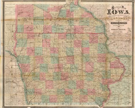
Iowa (Sectional Map of Iowa…), Cram, Chicago, 1871. 32.3 x 26.8”. (HC) This uncommon pocket map is highly detailed and filled with information including watershed, towns and early settlements, and wagon roads. It is colored by county with the county seat identified. The railway system is well developed throughout the state. The map carries the date of 1871 with a copyright date of 1869. The imprint is Cram`s Western Map Depot, 148 Lake St. Chicago, Ill. The map folds into original brown cloth boards with fancy embossed pattern and gilt title. Paper label on inside cover is the "Official Census of Iowa, 1870" and includes 3 pp. of population data. Ref: Rumsey no.3160.002 There is light toning along folds, and a few small separations and areas of loss along folds which have been closed on verso with archival materials. Narrow top and bottom margin, as issued. (B)

Tennessee (The State of Tennessee), Carey, General Atlas…, Philadelphia, ca. 1814. 20.8 x 9.8”. (HC) This fine map of Tennessee shows the state at an early point in its development with only twelve organized counties in the Mero and Washington Districts. The majority of the state is shown to be Cherokee tribal territory. The map depicts a few settlements, forts, trails, and roads, two of which venture out into Cherokee country toward the Tennessee River. This map lacks the engraved "22" plate mark above the neatline, and could possibly represent an unrecorded first state of the map which first appeared in Carey`s General Atlas in 1814. Good impression and original outline color with light toning centerfold and scattered foxing. (+B)
![Maine ([Lot of 2] Map of the Northern Part of the State of Maine and the Adjacent British Provinces… [and] Extract from](http://lot-images.atgmedia.com/SR/36385/2862480/253-2012510162359_468x382.jpg)
Maine ([Lot of 2] Map of the Northern Part of the State of Maine and the Adjacent British Provinces… [and] Extract from a Map of the British and French Dominions in the North America by Jno. Mitchell), U.S. Government, Sen. Doc. 502, 25th Cong., 2nd Sess., [1838]. 16.5 x 15.3”. (HC) The first map details the boundary dispute between the United States and Great Britain relating to Maine. Hand coloring is used to show the boundary as claimed by the United States and by Great Britain, with a third line labeled "that of the Arbiter" which closely corresponds to Maine`s present-day border with Canada. A table gives the major points of contention in this border dispute. Another table names land grants belonging to six land holders. The second map (13.3 x 13") was included in the same Senate report for historical purposes. It was extracted from Mitchell`s map of 1755 by W.J. Stone. Both maps are still bound into the original 16 pp. report. Ref: Claussen & Friis no.223; Phillips (M) p. 384. Map of the Northern Part... has light offsetting and a hint of toning with a binding trim at left. Extract from a Map... also has light offsetting and toning with a binding tear at right that extends 0.5" into the image. Both issued folding. (+B)

Boston, Massachusetts (Boston and Surroundings), Walker Lithograpic & Publishing Co., Boston, ca. 1910. 27 x 41”. (PC) This is a large format folding map of the greater Boston area. It is highly detailed showing street names, bridges, railroads, parks and docks. Published by the Walker Lithographic & Publishing Co., 400 Newbury St, Boston on behalf of the New England News Company. Folds into tan paper wrappers measuring 4 x 8". Bright and clean example with a few small splits at fold intersections and light toning where the map folds into its wrappers. Front wrapper is detached. (+B)
![Cape Cod, Massachusetts ([Lot of 2] Map of Cape Cod and Vicinity [and] Automobile Map of Massachusetts. Cape Cod), Walker Lit](http://lot-images.atgmedia.com/SR/36385/2862480/264-2012510162447_468x382.jpg)
Cape Cod, Massachusetts ([Lot of 2] Map of Cape Cod and Vicinity [and] Automobile Map of Massachusetts. Cape Cod), Walker Lithograpic & Publishing Co., Boston, ca. 1900-08. x ”. (PC) This lot features two automobile maps of the Cape Cod area including Nantucket and Martha`s Vineyard, both published by the Walker Lithographic & Publishing company. The maps display the "best" highway routes in red and show numerous other roads, railroads and abundant coastline. Both maps are dissected and mounted onto linen with brown paper labels. A. Map of Cape Cod and Vicinity, circa 1900, (18.5" x 20.5"). Condition: Light toning and a few minor spots, else very good. (B+) B. Automobile Map of Massachusetts. Cape Cod, dated 1908, (29" x 30.8"). Condition: The map is toned and the linen is partially separated along a few of the fold intersections. (B) See descriptions. ()

New Jersey & New York (Partie Septentrionale du New-Jersey, et Positions des Armees Americaine et Britannique Apres le Passage de la Riviere du Nord, en 1776), Marshall, Vie de George Washington, Philadelphia, ca. 1807. 9.8 x 15.5”. (BW) This map illustrates the military operations of the American Revolution in northern New Jersey during the late fall of 1776 and the early summer of 1777. The locations of the armies, with dates, are shown along with roads, towns, rivers, etc. The map extends to include Trenton and Sandy Hook, north to Tappan and Dobbs Ferry, and to New York City, Staten Island and the western part of Long Island. This map appeared in the French edition of Marshall`s Life of Washington. Ref: Fite & Freeman no.66 (English edition). Light offsetting and a couple of faint spots. (+B)
-
534325 item(s)/page