![[Lot of 4] Battle Monument, Baltimore [and] [Views of Washington, D.C.] A. [Lot of 2] Battle Monument, Baltimore, by W. Good](http://lot-images.atgmedia.com/SR/36385/2906594/155-201458125844_468x382.jpg)

[Lot of 4] Battle Monument, Baltimore [and] [Views of Washington, D.C.] A. [Lot of 2] Battle Monument, Baltimore, by W. Goodacre, Jr., from History and Topography of the United States of North America, circa 1834, (7.8 x 6.7""). This evocative engraving shows the Battle Monument on North Calvert Street in Baltimore. A man and child sit at the foot of the monument, which was erected to commemorate the Battle of Baltimore and those who died in the War of 1812 in the month of September 1814. Published by Samuel Walker and engraved by Archer & Boilly. This lot includes two copies of this print. Condition: Both prints have a few small spots within the image and marginal soiling. The one pictured in the first image has a chip out of its bottom left corner, well away from image. (A)B. Battle Monument, Baltimore, by William Henry Bartlett, from American Scenery, circa 1840 (7.4 x 5.6""). Another lovely print of the Battle Monument, which stands in the center of a bustling street scene. The stately elegance of Maximilian Godefroy`s design, from the cenotaph base up to the Roman fasces column, is prominently shown, topped with Antonio Capellano`s iconic Lady Baltimore statue. Published by George Virtue and engraved by Henry Griffiths. Condition: On a sturdy, slightly toned sheet, trimmed to the neatline at top and remargined with tissue. (B)C. [Views of Washington, DC], by H.F. Sumner, from A Book of the United States..., circa 1839 (5.4 x 8.8""). Two pages from A Book of the United States... featuring four views of government buildings in America`s capitol. At the top of the first page is the White House, here called President`s House, with a man and woman standing outside the gates. Below is the Capitol building, depicted before the dome was capped by the iconic Statue of Freedom. An engraving inside the empty chamber of the House of Representatives is at the top of the second page, with a view of the Department of State beneath. The measurement refers to the size of the individual pages. Condition: Both pages are attached to a matte measuring 12.1 x 8.9"", with each view visible through cut-out frames. Light scattered foxing in the text that does not impact the images. (B+) See description above. 1834-40
We found 534310 price guide item(s) matching your search
There are 534310 lots that match your search criteria. Subscribe now to get instant access to the full price guide service.
Click here to subscribe- List
- Grid
-
534310 item(s)/page
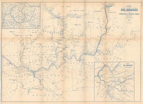
The Oil Regions of Pennsylvania and Western Virginia This very early map of the oil regions in Pennsylvania and West Virginia includes a large inset (8.8 x 8.8"") entitled ""Map of the Oil District of Western Virginia"" and an untitled inset (8.5 x 6"") showing Crawford, Warren, Venango, Mercer and Clarion Counties. The map is very detailed and notes locations of oil wells with the main map also giving extensive property ownership information. The map extends from Utica east to Oil Spring in Kingsley County in the east, and from Oil Creek south to Franklin and beyond to Rockland County. Locates Oil City, and numerous individual wells. The town of Cornplanter, named after a Seneca Indian chief, was renamed Oil City and became the major center, along with Titusville, for the area we know today as the Oil Regions. Printed in blue ink. Issued folding with a few short splits at fold intersections, some minor foxing, and light toning along the folds. 22.3 W x 30.8 H Sweet, S.H. 1865

Carte de la Partie Sud des Etats Unis de l`Amerique Septentrionale Attractive and concise copper-engraved map that covers the states of Virginia, North and South Carolina, and Georgia in the new United States. All settlement is confined east of the Appalachians with les Cherokees the only note in the otherwise blank region west of the mountains. There are four distance scales located on the left side of the map. On watermarked paper with light offsetting and a printer`s crease at bottom left. 8.4 W x 12.4 H Bonne, Rigobert 1780

Carte de la Floride et de la Georgie Handsome early map covering from South Carolina to Florida and the Bahamas and much of the lower Mississippi valley. The map depicts Florida and southern Louisiana during the period it was controlled by the Spanish. There are no engraved political divisions indicating the mapmaker`s bias toward the territorial claims of either Spain or the United States. In Georgia, settlement is confined to east of the mountains, while a large number of Indian villages and a few French forts are shown on the western frontier. The map provides an excellent view of the Gulf Coast with a dramatically oversized Tampa Bay (Baie de St. Esprit), reflecting the limits of contemporary knowledge of the region. Numerous Indian villages are located and roads are shown connecting early settlements. In central Florida the southern-most settlements are Dest, Suliga and Allavatra. The Bahamas are also well delineated. Published by Chanlaire & Mentelle and engraved by P.J. Valet. A nice impression on watermarked paper with light toning along sheet edges. 12.9 W x 16.8 H Tardieu, Pierre Francois 1797
![[Lot of 2] Amer. Sep. Partie des Etats Unis. No. 57 [and] Amer. Sep. Partie des Etats-Unis. No. 57 (bis) A. Amer. Sep. Parti](http://lot-images.atgmedia.com/SR/36385/2906594/163-201458125858_468x382.jpg)
[Lot of 2] Amer. Sep. Partie des Etats Unis. No. 57 [and] Amer. Sep. Partie des Etats-Unis. No. 57 (bis) A. Amer. Sep. Partie des Etats Unis. No. 57 (19.4 x 18.2""). Covers the region from northern Florida to southern North Carolina. Shows the topography of the southern Appalachians and river system and lists numerous towns and cities. Condition: An attractive example in original color with just a few small, faint spots of foxing. (A) B. Amer. Sep. Partie des Etats-Unis. No. 57 (bis) (19.4 x 19.8""). This sheet, comprised mostly of text, includes the Outer Banks of North Carolina along with an inset of Bermuda. Condition: Original color with light color offsetting and a few spots of foxing. (B+) The Atlas Universel contained 400 maps in six volumes. It was the first atlas made up of lithographed maps, and the first to present all the maps on the same scale (1: 1,641,836), with each map covering an area of approximately 20 degrees longitude (from Paris) and 6 degrees of latitude. If all the maps were joined together they would form a globe of 7.75 meters in diameter. The maps were published by subscription between 1825 and 1827, with each part containing ten maps. There was only one edition and the subscription list shows that 810 copies were sold; thus the maps are quite rare. See description above. 18.2 W x 19.4 H Vandermaelen, Philippe Marie Guillaume 1825

Map of the Southern States, Including Rail Roads, County Towns, State Capitals, County Roads, the Southern Coast from Delaware to Texas, Showing the Harbors, Inlets, Forts and Position of Blockading Ships This terrific Civil War map shows good detail of the towns, villages, railroads, and the ship blockade of the south. The title continues along the bottom: ""Prepared for Harper`s History of the Rebellion. December, 1863."" Surrounded by a very decorative border, it features portraits at each corner of Lincoln, Seward, Gen. Scott, and Gen. McClellan. An inset of ""Florida. Southern Part."" lies at lower right. On the verso are three black and white wood engraved birds-eye views, two single page and a large double page. The double page view details the region around the Chesapeake Bay and is titled ""Pictorial Map of Portions of Delaware, Maryland, Virginia, and North Carolina "" The other two are ""Balloon View of Fortress Monroe and Hampton Roads"" and ""Balloon View of the Seat of War."" An uncommon issue. Folding, as issued. This example has terrific original coloring, full margins, and a dark impression with a small chip out of Georgia. There is light toning along one fold, numerous fold splits, and some marginal tears or chipping, all of which are closed on verso with archival tape. Shows much better than the condition suggests. 20.1 W x 30.1 H Harper`s Weekly, 1863

Carte de la Louisiane et Pays Voisins pour Servir a l`Histoire Generale des Voyages Superb small map based on Delisle`s map of the French colony of Louisiana. This finely engraved and detailed map of French Louisiana extends from the Great Lakes to the Gulf of Mexico and from Nouveau Mexique to Florida (not showing the tip of Florida). Many Indian place names, forts and early European settlements are shown. Nouveau Mexique in the far west includes Santa Fe and names the S. Jerome de Taos. The decorative title cartouche includes the distance scale. Issued folding on watermarked paper with faint offsetting and a few light stains. 8.7 W x 12 H Bellin, Jacques Nicolas 1757

N.W. Territory This is the earliest printed map to show the North West Territory. It covers the region of the upper Mississippi Valley and the Great Lakes, and shows the rivers and streams together with settlements, mines, and forts. Lit. Fort appears at the mouth of the Chicago River and Old Ft. Orleans appears on the Missouri River. The southern end of Lake Michigan is placed almost a full degree further north than the southern shore of Lake Erie, an error that resulted in a series of boundary disputes between Michigan and its neighbors in the 19th century. The fictitious Charlevoix-Bellin islands appear in Lake Superior. This is the second state which is geographically identical to the first, with only the addition of two small lines to strengthen the tiny circles locating the towns of Detroit, Sandusky, etc. Accompanied by three loose sheets of text containing an entry on the North West Territory. Issued folding, now flat, with light soiling. 7.3 W x 6.2 H Scott, Joseph 1800

Geographical, Statistical, and Historical Map of Arkansas Territory For this commercial atlas version of the seminal Stephen Long report map, Carey & Lea chose a single sheet format at a reduced scale with the political boundaries highlighted in color. It carries the cartouche title Map of Arkansas and Other Territories of the United States Respectfully inscribed to the Hon. J.C. Calhoun Secretary of War by S.H. Long Major T. Engineers and appears on a full folio sheet with text measuring 20.5 x 16.6"". This is one of the most important maps of the American West, which Wheat calls the ""most interesting map in this Atlas."" It covers the Missouri River Basin north to the Mandan villages and west to the Rocky Mountains. Long`s map corrected a number of geographical inaccuracies, foremost the erroneous course of the Red River. As on Long`s manuscript map the ""Highest Peak,"" James Peak, and Spanish Peaks appear and the route of his expeditions are clearly delineated. Extraneous details, including Major Long`s astronomical notations, camp site locations, and elevation profile were eliminated, and information about Arkansas and surrounding territories was added in columns framing the map at the sides. South of the Republican Fork appears the significant legend that reads ""The Great Desert is frequented by roving bands of Indians who have no fixed place of residence but roam from place to place in quest of game""; this is a change from Long`s report map, where he famously referred to the ""Great American Desert."" A note refers to ""Pawnee villages deserted in 1810,"" whereas the Long map uses the date of 1820. Salt works, Potatoe Hills, a large number of Indian villages and lands, A Broad and extensive swell of Land called by the French Coteau de Prairie, and Say`s route are located, along. Thomas Say was the expedition`s naturalist and entomologist, and is considered to be the father of American entomology. Engraved by Young & Delleker.Claims are sometimes made that this first edition (1822) Carey & Lea map preceded the publication of the Long report map based on the report`s date of 1823. However, both were actually published in 1822, making the distinction impossible to tell from date alone. Even Wheat erroneously assigns an 1823 date to the Long report map. A mystery that deserves further study. Original hand color with toning concentrated mostly along the centerfold, light offsetting, and a couple of spots in the text columns. There is a centerfold separation at bottom that does not enter the map. 14.5 W x 14.7 H Carey & Lea, 1822

North America Sheet V The North West and Michigan Territories This is an interesting map of most of the Northwest Territory and Michigan Territory. It has the elongated Lake Michigan and bears some resemblance to Burr`s map of 1831. The Ottawa and Miami Indian nations are shown occupying the whole northern part of Michigan and the only settlement in the North West Territory is Green Bay Township along with Fort Howard. There are a few minor abrasions, light toning along sheet edges, and a small professionally repaired hole at top right. 12.3 W x 15.3 H SDUK Society for the Diffusion of Useful Knowledge, 1833

Map Showing the Lands Assigned to Emigrant Indians West of Arkansas & Missouri This attractive map was originally published in 1836 in the ""Report of the Dragoons under command of Colonel Henry Dodge to the Rocky Mts. during the Summer of 1835."" Because of its scarcity and importance, it was reissued in the American State Papers (ASP) circa 1860. The map covers the region of present-day Iowa, Nebraska, Kansas and Oklahoma, with the tribal lands outlined. An inset provides tabulations of the numbers of Indians and a listing of estimated acres of land assigned to these Tribes. While it shows the Santa Fe Road, the route of Col. Dodge is not depicted. The map is based on the 1836 map that was prepared by Lt. Washington Hood. Wheat calls this ""an important historical map."" It documents an ugly phase of American history during the first half of the 19th century when Indian tribes were forced to migrate to areas outside of their ancestral lands. This is an American State Papers edition. Issued folding, now flattened with light offsetting and archival repairs to a number of fold separations. 18.7 W x 17.9 H U.S. War Dept., 1860

Johnson`s Nebraska, Dakota, Colorado, & Kansas This colorful map features Nebraska with a long panhandle that extends all the way to about present-day Idaho near Ft. Bridger and Fremont`s Peak. Above Nebraska is a huge Dakota Territory that extends all the way to the Canadian border, west to the Continental Divide and east to Minnesota Territory. The map is filled with information and locates numerous Indian tribes, trading posts, wagon roads and trails, exploration routes, mountain peaks, and more. Shows the railroad routes explored by Gov. Stephens, Lt. Beckwith, and Capt. Gunnision, as well as numerous forts and early settlements. The Oregon Trail is shown but not named and several other emigrant roads are shown including several converging on Denver. Names the North, Middle, and South Parks, as well as several forts and a few towns in Colorado. Original color with light scattered foxing and some minor toning that is mostly concentrated in the blank margins. 12.5 W x 15.4 H Johnson & Ward, 1862-63

Map of Minnesota Territory This well engraved map is the second map to show the newly created Minnesota Territory, and is largely based on the works of Nicollet and Pope, the latter of whom is credited with the first map of the new territory. This is Cowperthwait`s first map of the territory, showing very early county development extending in horizontal strips extending to the Missouri River. Nine counties are delineated, with Itasca, Benton, Ramsey and Washington east of the Mississippi River. Within Pembina, the northernmost region, is the large Salt Water Region. Additional counties are Mahkahta, Wahnahta, Dahkotah, and Wabashaw. Settlement is almost exclusively along the Mississippi River. Many Indian tribes are located, including the Assiniboine, Yanktonan, Chippeway, Mennomonees, Winebagoes, etc. Forts along the Missouri River include aux Cedres, Lookout, Pierre Choteau, Clarke, and Mandan (noted as the wintering place of Lewis and Clarke in 1804-05). This issue does not show the settlement of Minneapolis, which first began to appear the following year. Fancy titling and decorative borders. This detailed and interesting map documents the early stages of development of Minnesota and the Dakotas. Original color with light toning. Very narrow bottom margin, as issued. 13.3 W x 16.1 H Thomas, Cowperthwait & Co., 1850

Oregon and California This terrific western map from the era of the California Gold Rush covers roughly the same area as J.C. Fremont`s celebrated map of the west. The map extends as far east as Santa Fe and includes many towns and cities, rivers, lakes, and mountains. It features a large Oregon Territory which stretches to the Continental Divide and north to the border with Canada. A note at the border reads, ""Boundary Line between Great Britain and United States as settled June 15th 1846."" Another note runs along the U.S.-Mexico border, dating its establishment in 1848. Pyramid Lake and the Timpanogos or Gt. Salt L. are located, but there is no sign of Bigler Lake or Lake Tahoe. There is not a direct mention of gold mining activities but the important ore bearing rivers are shown and named. Published by A. Fullarton & Co. Light scattered foxing with a small damp stain confined to the top blank margin. 9.1 W x 6.1 H Swanston, George H. 1850

Progress Map of the U.S. Geographical Surveys West of the 100th Meridian A remarkable and attractive map that reflects the survey efforts in the West. It is a detailed representation of the various routes of western expeditions and the important surveys of King (40th parallel), Wheeler, Powell & Hayden. This edition includes the survey seasons of 1869, and 1871 through 1879. Among the details are the locations of occupied and abandoned posts, astronomical stations, signal service stations and the ""Route for Cattle Droves & Trains from Texas to Cal."" Published in Lieut. George M. Wheeler`s Annual Report under the direction of Brig. Gen. H.G. Wright, Chief of Engineers. Issued folding with light toning and a few short splits at fold intersections. 17.5 W x 22.3 H Wheeler, George (Lt) 1881

Hittell`s Hand-Book of Pacific Coast Travel This travel guide covering the western United States includes two folding maps by Bancroft including Bancroft`s Map of California and Nevada 1887 (11 x 13"") and Bancroft`s Map of Washington Territory and Oregon 1887 (10.7 x 14.3""). Each of the maps is highly detailed and shows cities and towns, railroads, wagon roads, rivers and topography. The maps are still bound into the 263 pp. guide which describes the ""notable views"" along the various railroads routes from the east, as well as information regarding climate, places to visit and distance tables. Published by John Hittell in San Francisco. Hardbound in green cloth with gilt title on front cover. Maps are good to very good with some light toning primarily along the folds and several fold separations that have been closed on verso with archival tape. Contents are very good with light toning and a few pen notations. The covers show light wear. 6.6 W x 4.8 H 1887
![[Lot of 2] Map of the United States Territory of Oregon West of the Rocky Mountains, Exhibiting the Various Trading Depots o](http://lot-images.atgmedia.com/SR/36385/2906594/194-201458125954_468x382.jpg)
[Lot of 2] Map of the United States Territory of Oregon West of the Rocky Mountains, Exhibiting the Various Trading Depots or Forts Occupied by the British Hudson Bay Company... [and] Chart of the Columbia River for 90 Miles from Its Mouth... A. Map of the United States Territory of Oregon West of the Rocky Mountains, Exhibiting the Various Trading Depots or Forts Occupied by the British Hudson Bay Company..., dated 1838 (20.6 x 17.4""). This map accompanied an important report intended to awaken public interest in the American occupation of Oregon Territory in the controversy with Great Britain, who also claimed the territory south to the Columbia River. Among the many interesting details are the locations of the various trading posts or forts connected with the American and British northwestern fur trade. The map covers present day Oregon, Washington, Idaho, Montana and Wyoming. The region east of the Rocky Mountains is named Mandan District. It also shows much of southwestern Canada. The map was copied from John Arrowsmith`s 1832 map of British North America. At lower left is the wording of an ultimatum given to the British by Henry Clay, Secretary of State, stating that the 49th parallel will be the boundary. Engraved by M.H. Stansbury. B. Chart of the Columbia River for 90 Miles from Its Mouth. Drawn from Several Surveys in the Possession of W.A. Slacum U.S.N., circa 1838 (9.1 x 16.3""). This is a companion map to the above depicting the river from Point Adams/Cape Disappointment east to Ft. Vancouver, showing villages along the way. The map shows the navigability of the river with soundings, sand bars and islands. It was drawn from several surveys in the possession of W. A. Slacum, USN. Issued folding with some light stains and minor soiling in the images. A few short splits at fold intersections have been closed on verso with archival tape. Albert/Hood, 1838

A Map of the Internal Provinces of New Spain This map was included in Pikes landmark report of the Southwest, describing his expeditions from 1805-1807. His book is one of the most important of all American travel narratives, and stands alongside those of Lewis and Clark as a cornerstone of early western exploration. The report itself (not included) contains accounts of Pike`s travels to find the headwaters of the Arkansas and Red Rivers, his explorations along the Mississippi River, and his Spanish escort to Santa Fe, New Mexico and Chihuahua, Mexico. Contained within the report are six maps including this one focused on the Southwest and much of what is now Texas, New Mexico, Arizona, southern Colorado and northern Mexico. Shown are boundaries between provinces, capitals of provinces or kingdoms, Spanish villages, Indian villages or towns, Spanish towns of consequence, fortified towns or forts garrisoned, springs or fountains, old towns excavated, roads, and the route traveled by Pikes troops in 1807. Additional features include the locations of numerous ranchos, mines, and notations such as ""Immense herds of wild horses,"" ""Immense plains used as pasturage by the Cibolas,"" and Indian tribe names. Issued folding and now flattened and backed with heavy tissue to extend the narrow margins and to reinforce and repair numerous short and long fold separations. Light soiling and offsetting. 18 W x 18.6 H Pike, Zebulon 1810
![[Lot of 4 - Fort Smith and Santa Fe Route] This historical and finely detailed set of maps covers the route of the expeditio](http://lot-images.atgmedia.com/SR/36385/2906594/199-2014581303_468x382.jpg)
[Lot of 4 - Fort Smith and Santa Fe Route] This historical and finely detailed set of maps covers the route of the expedition on a scale of 10 miles to the inch. The four sheets display the entire route, which initially crossed present-day Oklahoma, continued along the Canadian River to the llano Estacado in Texas` panhandle and finally into eastern New Mexico. Filled with details encountered along the way, it includes forts, rivers and creeks, topography, and many notes on wildlife, geological, emigrant roads, Indian tribes and villages, availability of water and wood. Every camp site is located and numbered. A table of distances appears on each map. One curious note just east of Albuquerque states that ""Fish with legs found in this pond."" This expedition represents the first detailed mapping of the area, and Simpson found the route to be ""superior"" and practicable for a railroad. The survey was made with a chain and compass checked by astronomical observations made with a sextant and chronometer. Simpson credits the surveys of the Canadian River and of New Mexico, made in 1845 - 46 & 47, by Lieut. T. Abert of the Topographical Engineers in the preparation of his maps. The maps were drawn by Lt. Simpson with the assistance of Mr. E.M. Kern and Mr. Champlin. Wheat notes the original drawings for these four maps are preserved in the National Archives. See Wheat Volume III for further details on the importance and accomplishments of Simpson` expedition. A. Map of Route Pursued by U.S. Troops from Fort Smith, Arkansas, to Santa Fe, New Mexico, via South Side of Canadian River in the Year 1849... (19.1 x 10.9""). B. Map, No. 2. Showing a Continuation of Details of Fort Smith and Santa Fe Route from Old Fort Holmes to Mounds Near 100 1/2 Degree of Longitude (19.6 x 11.1""). C. Map, No. 3, Showing Continuation of Details of Fort Smith and Santa Fe Route, from Mounds Near 100 1/2 degree of W. Longitude to Tucumcari Creek (20.3 x 12.5""). D. Map, No. 4 Showing Continuation of Fort Smith and Santa Fe Route from Tucumcari Creek to Santa Fe (18.8 x 12.6""). Issued folding with light toning and some minor scattered foxing. Simpson, James H. (Lt. Col.) 1849
![[Lot of 8] [Maps of the Mexican Boundary Survey] [in report] Executive Documents Printed by Order of the Senate of the Unite](http://lot-images.atgmedia.com/SR/36385/2906594/200-2014581308_468x382.jpg)
[Lot of 8] [Maps of the Mexican Boundary Survey] [in report] Executive Documents Printed by Order of the Senate of the United States, During the First Session of the Thirty-Second Congress The process of surveying the US-Mexican Boundary was beset by politics, interdepartmental rivalries and personal conflicts from the beginning. Ultimately, the dispute between the principals (mainly Bartlett and Graham) made its way to the floor of Congress and the claims and counterclaims ended up in numerous government documents. Senate document 119 includes correspondences, reports and documents and is the source of these seven maps: A. That Part of Disturnells Treaty Map in the Vicinity of the Rio Grande and Southern Boundary of New Mexico (11 x 8.8""). This map is centered roughly on Santa Fe and covers the area from the Arkansas River south to the 31st parallel, locating Albuquerque and Tucson. The parallels were being corrected from an incorrect position previously mapped, and this map illustrates both old and new parallels. Ref: Wheat (TMW) #719. B. Mexican Boundary, Sketch A. Referred to in Colonel Grahams Report to the Hon: The Secretary of the Interior of August 16th 1851 (18 x 5.0""). Ref: Wheat (TMW) #717. C. Mexican Boundary B, Extract from the Treaty Map of Disturnell of 1847 (15.3 x 9.0""). Ref: Wheat (TMW) #718. D. No. 1 Map Exhibiting the Southern Boundary of New Mexico As Respectively Claimed by the United States and the Mexican Commissioners under the 5th Article of the Treaty of Guadalupe Hidalgo (10.9 x 7.5""). E. No. 2 [from Emorys Map] Accompanying Commissioner Bartletts Letter to the Secretary of the Interior, Dated Santa Rita Del Cobre August 8th 1851 (12 x 7.8""). Ref: Wheat (TMW) #704. F. No. 1 Accompanying Commissioner Bartletts Letter to the Secretary of the Interior, Dated Santa Rita Del Cobre August 8th 1851 (6.6 x 5.8""). Ref: Wheat (TMW) #703. G. No 2. Disturnels Map Exhibiting the Error in the Rio Grandes Position (10.7 x 8.0""). Ref: Wheat (TMW) #706. 515 pp. Octavo, hardbound in full Congressional calf with maroon label and gilt title on spine. The maps are generally very good with some light to moderate toning primarily along the folds and some occasional offsetting. Text is generally clean and tight with some scattered faint foxing. The hinges are starting, the covers are worn with the back cover almost detached, and the spine is cracked and abraded. 8.9 W x 5.8 H U.S. Government, 1852

Johnson`s California Territories of New Mexico and Utah This is an uncommon edition from this great series of maps covering the Southwest, with the newly formed Nevada shown occupying part of California to the summit line of the Sierras. The western border of Nevada extends south from Goose Lake (just west of the 120th meridian) and then continues along the Sierra Nevada Mountains, and finally extends east to meet with the southern border of Utah. The Utah/Nevada border is also too far west on the 116th meridian. Arrizona shows up in the southern part of New Mexico Territory. This is thought to represent the Confederate Territory of Arizona that existed for nearly a year from August 1861 until July of 1862. The Confederate General Baylor appointed himself the territorial governor and claimed all of New Mexico Territory south of the 34th parallel. In the southern part of Arizona is the ""Gadsden Ten Million Purchase of Mexico."" The Gold Region in Colorado`s South Park is prominently shown, along with the Hastings Road and the routes of numerous explorers and military expeditions. The map is filled with historic and interesting notations. One note in the area of Quartzite, Arizona refers to the area as being ""exceedingly fertile and abundantly timbered and well watered."" Additional details include the U.S. Mail routes, the Emigrant road to California, the proposed railroad route through Utah, Nevada and California, and the Pony Express trail, the last time it appears on this series of map. Johnson was diligent in constantly revising his plates with new information; according to Dr. Ira Laurie`s Johnson U.S. Map Project, this is the third of 8 versions of this map. A great map of the Southwest. Original color with light toning, minor foxing, and an archivally repaired centerfold separation in bottom blank margin. 16.9 W x 24.5 H Johnson & Browning, 1861

Johnson`s California, Also Utah, Nevada, Colorado, New Mexico, and Arizona Johnson`s series of maps of the American Southwest is one of the most interesting progressions in 19th century American cartography. The series was produced during a time of rapid westward expansion and changes in territorial boundaries. This edition includes the original four counties of Yavapai, Mohave, Yuma, and Pima in the newly organized Arizona Territory, with Prescott as the capital. The Utah/Nevada border is now at 114° and Arizona and Nevada have their final borders. Early historical details include the Pony Express and United States Mail routes, the emigrant roads to California, and the proposed southern railroad route. Historical and statistical information on the verso. Original color with faint offsetting and light toning in the blank margins. 17 W x 23.4 H Johnson, A. J. 1864

Alaskan Boundary Tribunal Atlas of Award Twenty-Five Sectional Maps and Index Map Showing the Line Fixed by the Tribunal This atlas shows in great detail the end result of the Alaskan Boundary Tribunal. There are twenty-five maps consisting of 21 double-page sectional maps, three single-page sectional maps, and an index map. Some of the maps have facsimile notes signed by members of the commission. The Alaska boundary dispute of 1903 concerned the southernmost portion of Alaska and its border with Canada. Although seemingly insignificant today, it was a hotly debated issue in its time. Folio. Hardbound in maroon cloth with gilt title on front cover. The maps are in near fine condition with only light toning along sheet edges. The hinges are starting, the covers are lightly worn, and there is a small chip at the bottom of the spine. An overall attractive example. 19.1 W x 16.2 H U.S. Gov`t Printing Office, 1904
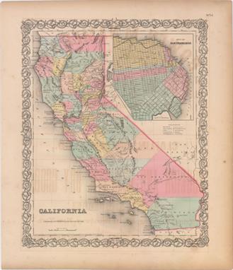
California This is one of the best mid-nineteenth century atlas maps of California. It shows the entire state with Utah and New Mexico territories on the eastern border. Two proposed railroad routes through the Central Valley are labeled ""Explored Route for Atlantic & Pacific R.R."" and a northern route through Fredonyers Pass, north of Pyramid Lake, is marked ""Practicable Route for Atlantic & Pacific R.R."" The only completed railroads service the Gold Regions and Sacramento. A huge inset titled ""City of San Francisco"" shows the planned land expansion into the bay with the streets already drawn in. There is offsetting in the image from an opposing page of text and light toning along the sheet edges. 14.8 W x 11.8 H Colton, Joseph Hutchins 1855
![[Lot of 5] [4 Coast Charts] [with report] A Series of Charts with Sailing Directions These charts of the San Francisco Bay a](http://lot-images.atgmedia.com/SR/36385/2906594/210-20145813025_468x382.jpg)
[Lot of 5] [4 Coast Charts] [with report] A Series of Charts with Sailing Directions These charts of the San Francisco Bay and associated headwaters were produced by Cadwalader Ringgold, who had a long and distinguished naval career, including commanding the Porpoise in the Wilkes Exploring Expedition from 1838-1842 where he made his first surveys of the northwest coast of America. In 1849 he returned to California where he completed the work A Series of Charts, with Sailing Directions that resulted in the present charts, which was precipitated by the flood of emigration to the anchorage of San Francisco and on the unexplored routes leading to the interior. Ringgold`s set of maps served as an important pilot guide to the water routes leading to the gold regions. There were a total of six maps issued with his report, of which this lot includes four: A. General Chart Embracing Surveys of the Farallones Entrance to the Bay of San Francisco..., (30.3 x 20.5"").B. Chart of the Bay of San Pablo Straits of Carquines and Part of the Bay of San Francisco California, (20.6 x 30.5"").C. Chart of Suisun & Vallejo Bays with the Confluence of the Rivers Sacramento and San Joaquin California, (30.4 x 20.4"").D. Chart of the Sacramento River from the Suisun City to the American River California, (20.4 x 30.1""). This is an uncommon issuance as the maps have never been folded. Included with the maps is Ringgold`s 44-page report. Maps are on sturdy sheets which are generally clean and bright with some areas of light to moderate scattered foxing. Report is lightly toned with a few small edge tears and creases. Ringgold, Cadwalader 1851

Map No. 1 From San Francisco Bay to the Northern Boundary of California from Explorations and Surveys Made Under the Direction of Hon. Jefferson Davis... This map is quite detailed along the coast from San Francisco Bay to the northern border with Oregon with place names, watershed and fine hachure in the mountainous areas. The balance of the map is mostly in skeletal format with an area to the west is noted as Not Explored Instrumentally. Locates the Emigrant Trail plus the earlier explorations of Warner and Williamson in 1849, and Wessell in 1852. Notes the place Warner was killed in 1849. Topography on the map was not added by this survey but taken from numerous sources including Fremont`s ""Map of Oregon and Upper California."" Issued folding, now pressed and backed in Japanese tissue to repair some short fold separations. There are a few tiny spots of foxing and some light soiling. A binding trim at bottom left has been replaced with paper to accommodate framing. 27.2 W x 23.1 H Williamson & Abbot, 1855
![[Untitled - Adjutant`s Office California Coast] This untitled Mexican-American War map shows the southern California coast.](http://lot-images.atgmedia.com/SR/36385/2906594/213-20145813029_468x382.jpg)
[Untitled - Adjutant`s Office California Coast] This untitled Mexican-American War map shows the southern California coast. It names San Diego, Capistrano, San Gabriel, Angeles, Monterey, and Santa Clara. A road extends from San Diego north to the San Francisco peninsula then to Sonoma and ends at Sutter`s Mill (Suters) where gold would be discovered the following year. A table gives the distance between major posts and the number of soldiers posted at each. The troops of the Mormon Battalion are not included ""as their term of service expires in July."" The map is dated June 19, 1847 and is signed in the plate, ""Adjutant`s Office, Monterey, California."" Large inset details the Baja from C. San Lucas up to Loreto, locating La Paz and shows Guaymas on the mainland. An uncommon issue printed by the P.S. Duval company of Philadelphia. Issued folding with some light scattered foxing and an edge tear that just enters the neatline at left and has been repaired on verso with archival tape. Toning along the sheet`s top edge. 14.4 W x 11.8 H U.S. War Department, 1847
![[Lot of 4] Reconnaissance of the Tulares Valley... [and] Sketch of the Battle de Los Angeles Upper California... [and] Sketc](http://lot-images.atgmedia.com/SR/36385/2906594/214-20145813031_468x382.jpg)
[Lot of 4] Reconnaissance of the Tulares Valley... [and] Sketch of the Battle de Los Angeles Upper California... [and] Sketch of the Passage of the Rio San Gabriel, Upper California... [and] Sketch of the Actions Fought at San Pascal in Upper California.. A. Reconnaissance of the Tulares Valley Made by Order of Brev. Brig. Gen. Riley..., by Lt. George Horatio Derby, from Senate Exec. Doc. #110, 32nd Congress, 1st Sess., dated 1850 (18.4 x 14.9""). This interesting map of the area south of the San Joaquin River from the Pacific Ocean to the foothills of the Sierra Nevada Mountains was not published until 1852. The Road to Los Angeles runs through the center of the map. This road offers two routes to LA on either side of Tache Lake with the eastern-most route running along the base of the Sierra Nevada Mountains. The road from Monterey to San Louis Obispo names several villages along the way including Tores, Guadalupe, Soledad, Ojitas, and Paso de Rables (sic). Derby`s route is traced by dashed lines and several mountain passes are noted. Further, the map locates Warsaw on the road to Los Angeles at the River San Joaquin, and other interesting features such as ""Wild Horses."" Ref: Wheat (Gold) #150. Condition: Issued folding, now flat and backed in tissue, with faint offsetting, two extraneous creases at top right, and light toning along the top and bottom edges of the sheet, well away from image. (A)B. Sketch of the Battle de Los Angeles Upper California, Fought Between the Americans and Mexicans Jany. 9th 1847, by William Hemsley Emory, from Senate Doc., 30th Congress, 1st Sess., published 1847 (8.3 x 5.9""). This historically significant Mexican-American War map locates the Pueblo de Los Angeles, the Rio de Los Angeles, and positions of forces during this battle. Engraved by A. Kollner. Condition: Foxed throughout, especially along the centerfold, with a tiny burn and related hole in an unengraved area. (B)C. Sketch of the Passage of the Rio San Gabriel, Upper California, by the Americans, - Discomfiting the Opposing Mex. Forces, Jan. 8th 1847, by William Hemsley Emory, from Senate Doc., 30th Congress, 1st Sess., published 1847 (8.2 x 6.3""). Shows the American troops advancing across the Rio San Gabriel and the resulting withdrawal of Mexican forces. Condition: Faint toning along the centerfold with remnants of hinge tape on verso and an edge tear measuring less than 1"" confined to the blank margin. (B+)D. Sketch of the Actions Fought at San Pascal in Upper California Between the Americans and Mexicans Dec. 6th & 7th 1846, by William Hemsley Emory, from Senate Doc., 30th Congress, 1st Sess., published 1847 (7.9 x 11.2""). Depicts the battle between Kearny`s troops and those of Mexican Major Andres Pico. Once reinforcements arrived, Kearny was able to push Pico`s troops south and reach San Diego. Condition: Issued folding with scattered foxing and toning along the sheet`s edges. (B) See description above. U.S. War Department, 1847-52

City of San Francisco and Its Vicinity, California... This early plan of the city of San Francisco covers the region from North Point to Mission de Delores and to Point San Quentin. The city plan was derived from a number of sources, including Eddy`s official map of the city and the now rare map by Cooke and Le Count, with topography by A.F. Rodgers. The streets are clearly laid out and named with detail down to individual buildings and contour lines at 20 ft. intervals showing elevation. Buildings are shown in black along the streets in both San Francisco and Mission de Dolores, and a Plank Road connects the two communities. A key indicates sixteen public buildings and fifteen reservoirs and numerous notes describe the soundings and navigational hazards. Issued folding with several fold separations that have been closed on verso with archival tape. There is a binding trim at top left, an extraneous crease at bottom left, and light toning along the folds. 25.1 W x 18 H U.S. Coast Survey, 1853
![[Lot of 3] Improved E-Z Guide Map of Los Angeles and Surrounding Territory [and] A Map of the Business Section of Los Angele](http://lot-images.atgmedia.com/SR/36385/2906594/218-20145813037_468x382.jpg)
[Lot of 3] Improved E-Z Guide Map of Los Angeles and Surrounding Territory [and] A Map of the Business Section of Los Angeles [and] Los Angeles and Vicinity This lot features three maps over a seven-year period published by the Clason Map Company including: A. Improved E-Z Guide Map of Los Angeles and Surrounding Territory, dated 1924, printed color (16.6 x 12.9""). This is an unusual and highly useful map which allows a lot of detail to be displayed on a small sheet. It includes a lettered pointer and clock-like border which enables the user to easily find a given street location. A table at left and on verso provides the street listing and location coordinates. Published by the Security Trust & Savings Bank. Condition: Issued folding. (A+) B. A Map of the Business Section of Los Angeles, dated 1926, printed color (17.8 x 11.0""). This small folding promotional map is centered on Pershing Square and covers the area from Figueroa Street to Los Angeles Street and from First Street to Twelfth Street. Numerous individual buildings are named, with red overprinting identifying the publisher, Mullen & Bluett Clothiers. The verso contains a listing of businesses on the map and advertising for the publisher. Condition: (A+) C. Los Angeles and Vicinity Including Parts of North Hollywood - Burbank - ..., dated 1931, black & white (20.6 x 22.9""). This densely filled folding map covers the area from Griffith Park south to Inglewood. It depicts roads, streets, railroads, parks and cemeteries with an extensive street index below the map. Condition: Light offsetting. (B+) See description above. Clason Map Company, 1924-31

Map of Colorado Territory, and Northern Portion of New Mexico Showing the System of Parcs William Gilpin was the first governor of the territory of Colorado and a proponent of the concept of Manifest Destiny and of a transcontinental railway. This map is based on a similar map issued by Jacob Monk in 1865 and shows all of Colorado and part of northern New Mexico. It illustrates the continental divide and four major Parcs; North, Middle, South and San Luis [Valley]. Lesser parks are also noted, as are the status of public land surveys, military posts, mines, and towns. Locates the Denver and Rio Grande, Joseph & Denver, Kansas Pacific, Leavenworth & Denver, Union Pacific, and Denver Pacific railroads, plus a few others. A fascinating map that should be part of any Colorado collection. Printed by the J.B. Lippincott Company. Bold original color with light to moderate toning along the folds and several fold separations that have been closed on verso with archival tape resulting in minute loss of image. 20.3 W x 20.8 H Gilpin, William 1873

Carte Geographique, Statistique et Historique du District de Colombie This is a striking map of the capital city with north oriented to the top left corner by a compass rose and an arrow indicating the flow of the Potomac River. Washington, Georgetown and Alexandria are well depicted and a good part of the vicinity is also illustrated with major roads named. Buchon`s atlas is often called the French Carey & Lea, and it was printed on better quality paper than the maps issued from Philadelphia. The map is surrounded by French text providing details of climate, topography, commerce, religion, government, history and military battles. At the time, Washington, D.C. had a total population of only 33,000. Dimensions given are for the map only; with full text, size is 24.1 x 18.1"". Original color with light, uneven toning and some light foxing. 10.6 W x 10.1 H Buchon, Jean Alexandre 1825

Bohn`s Hand-Book of Washington. With an Appendix. Illustrated with Twenty Engravings of Public Buildings, &c. This is a terrific pocket map and tourist guide for the nation`s capital city. The map, Map of the City of Washington in the District of Columbia... (11.3 x 15.3"") is bound into the front of the book. It is printed on fine banknote-style paper and is surrounded with reference tables and information useful to tourists. It is embellished with fancy titling and compass rose, and large vignette of the Capitol building. Interspersed within the text are 17 finely rendered color plates which include the President`s House, U.S. Patent Office, Washington Monument and Navy Yard. Published by Casimir Bohn. Hardbound in green cloth with stamped gilt title and illustrations on front cover. The map is generally clean and bright with some light offsetting and a very short closed binding tear. Text and plates are very good with some faint scattered foxing. Covers and spine show light wear and the spine is slightly sunned. The front hinge is perished. 6.1 W x 3.9 H 1854

Chart of the Head of Navigation of the Potomac River. Surveyed by the Order of the Sec. of War for the Corporation of Georgetown D.C. with a View to the Improvement of the Georgetown Channel This uncommon map shows a portion of Georgetown and Washington D.C. along the Potomac River, and includes part of the Chesapeake and Ohio Canal as well as Rock Creek and the Basin. Names the major streets and shows the location of the Washington Monument. Within the Potomac River are hundreds of soundings with notes on the bottom material. Place names mentioned include Alexandria Road, the Alexandria Canal, Mason`s Island and Timber Creek. Made under the direction of Capt. L. C. Woodruff by R.W. Burgess of the Topographical Engineers. Engraved by Denis Callahan and printed by the esteemed firm of Julius Bien. A seldomly seen issue that should not be confused with the smaller reprint issued in 1891. Issued folding with numerous short splits at fold intersections, light toning along the folds, and a few spots of foxing. 24.6 W x 40 H U.S. War Department, 1857
![[Lot of 2] Map of the District of Columbia Showing Areas Recommended to Be Taken as Necessary for New Parks and Park Connect](http://lot-images.atgmedia.com/SR/36385/2906594/228-20145813055_468x382.jpg)
[Lot of 2] Map of the District of Columbia Showing Areas Recommended to Be Taken as Necessary for New Parks and Park Connections ... No. D-288 [and] ...Showing Public Reservations and Possessions and Areas Recommended ... No. D-289 These two maps show the same topographical detail but are used for different purposes. The first map (D-288) shows those areas (shaded in green) that are recommended to be purchased by the District. The map also shows proposed ""elevated drives"" along the Potomac River. The second map shows the areas to which the public has access. Areas highlighted in green are park areas, and the areas in yellow are public but were not intended to be parks (Arlington Cemetery, the Naval Observatory, Washington Barracks, etc). Published by A. Hoen in Baltimore. Issued folding with a narrow left side margin due to binding trim with one tiny binding tear closed on verso with archival tape. Light toning along the folds with a few short splits at fold intersections. 26.6 W x 26.6 H U.S. Government, 1901

Florida This is a revised edition of Tanner`s map of Florida showing towns, railroads, forts, roads, canals, major rivers, and lakes. There are references to forts, battlefields, and routes used by the Army during the Seminole War. There are also three inset maps detailing Pensacola, Tallahassee, and St. Augustine. The map reflects the configuration of counties in 1843, although Mosquito County is far too large. Water routes from St. Augustine and Pensacola to various ports are described along the upper and lower margins. Printed by H.N. Burroughs. Original color with light toning along sheet edges. 14.4 W x 11.7 H Mitchell, Samuel Augustus 1846
![[Lot of 6] A Plat Exhibiting ... State of Florida... [and] F. Diagram: Explanatory of the Surveys Proposed to Be Executed...](http://lot-images.atgmedia.com/SR/36385/2906594/230-2014581310_468x382.jpg)
[Lot of 6] A Plat Exhibiting ... State of Florida... [and] F. Diagram: Explanatory of the Surveys Proposed to Be Executed... [and] D. Diagram: of Tampa... [and] D. Diagram of St. Augustine... [and] Diagram of Tallahassee... [and] D. Diagram of Alachua... This lot contains six General Land Office maps depicting the extent of surveying in the state. Included is a large map of the entire state with five smaller land district maps showing south Florida, the panhandle, St. Augustine and Alachua. Lithographed by Hoen & Co. for Senate Doc. No.1, 34th Congress, 1st Session. A. A Plat Exhibiting the State of the Surveys in the State of Florida with References, (26.4 x 24.3""). This is a later edition of a map that was published in a few different congressional reports in the late 1840s. Almost the entire state has had at least some survey work performed with good detail of the Everglades. Condition: Issued folding with numerous fold separations that have been closed on verso with archival tape with some very minor loss at fold intersections. B. F. Diagram: Explanatory of the Surveys Proposed to Be Executed in the Order of Importance to the Interests of the Government, Marked 1, 2, 3, (11.3 x 15.2""). Very good detail of south Florida and the Everglades and notes ""Country occupied by the Seminoles."" Condition: Issued folding. C. D. Diagram: of Tampa Land District Shewing Those Townships in Which Swamp Lands Lists Have Been Sent Up..., (10.4 x 15.8""). Similar to the map above with only surveying information. Condition: Issued folding with a binding trim at lower left that results in some loss of border and text. D. D. Diagram of St. Augustine Land District Shewing the Townships in Which Swamp Land Lists Have Been Examined and Approved..., (7.1 x 8.4""). E. Diagram of Tallahassee Land District Shewing the Townships in Which Swamp Land Lists Have Been Examined and Approved..., (15.9 x 6.9""). Condition: Issued folding. F. D. Diagram of Alachua Land District Shewing the Townships in Which Swamp Land Lists Have Been Examined and Approved..., (7.6 x 6.3""). The maps have light toning, some occasional faint offsetting, and a few of the folding maps have some tiny splits at fold intersections. See description for more details. U.S. Government, 1855

Historical Map of Illinois Showing Early Discoveries, Explorations, Indian Villages, Missions, Trails, Battle Fields, Forts, Block Houses, First Settlements and Mail Routes... This uncommon map of Illinois outlines the history of the state from 1670 through 1880, with an extensive table at left listing events for each decade. Key events include ""Marquette winters at Chicago"" in 1674, ""French and English War on the frontier"" in 1689, ""500 slaves brought to the Illinois country"" in 1720, and ""first statute book of laws published in Illinois"" in 1807. The map is divided by county, with dates listing the year each county was organized. Key towns (along with their settlement dates), roads, railroad lines, Indian villages, missions, and forts are also shown. The exploration routes of Marquette and Joliet (1673) and La Salle (1679-82) are depicted. A table listing the census dates for Illinois between 1810 and 1880 appears above the title, showing the population increasing from 12,282 to 3,077,871 during that time period.The map was issued with a 128-page book on the History of Illinois. Two additional maps appear in the book, showing the location of Indian tribes in Illinois in 1684 and again in 1765. Notes explaining the large folding map are also included. The book has several signatures removed to make space for the folding map, which fits nicely inside the book but is not attached.Black quarter-faux leather over black cloth boards, with gilt embossed title on front cover and spine. Map is dissected and mounted on linen. The map is good with bright, original color and light soiling along a few folds. Trimmed at top and bottom with complete loss of border, as issued. The map is separating from the linen in numerous places. The book is in very good condition, with a faint damp stain at bottom right of the first half of the text, a repaired hinge, and light wear to covers and spine. A previous owner`s stamp on title page has been covered with old paper. 42.5 W x 27.4 H Blanchard, Rufus 1883

Map of the Bounty Lands in Illinois Territory According to Streeter, this seldomly seen map of Illinois Territory is the ""earliest Illinois Map."" It is also listed in Phillips A List of Maps of America as the first map under the Illinois header. The map itself covers the western portion of Illinois between the Mississippi River and the Illinois River, from just north of St. Louis to just south of Davenport, Iowa. Lake Peoria is here called Lake Peoire and the creek just to its west that flows into the Illinois River is labeled Kickaboo or Red Bud Cr. Below the map image is a printed grid with an area colored in green that corresponds to a tract in the map with the manuscript notation ""Gently rolling prairie good soil Spoon River in the SE 1/4 of this Section,"" signed by John Gardiner. Most, if not all, of these maps would have included similar notations regarding each tract of land that was being awarded. John Gardiner was the chief clerk of the General Land Office until 1821. Following the War of 1812, the GLO was tasked with surveying the frontier lands and quickly distributing them to war veterans as payment for their services. Issued folding with light toning and offsetting and a few minor spots of foxing. There are two small holes along the vertical fold with minute and insignificant loss or image: one to the left of the highlighted tract and one to the right of the fleur-de-lis. 18.6 W x 14.9 H Gardiner, John 1818

Map of Boston and the Country Adjacent, Showing Rural Parks as Proposed by Ernest W. Bowditch This uncommon pocket map of the greater Boston area is printed on fine banknote-style paper. It covers the region from Cohasset in the south, north to Swampscott, and westward to Lexington in the northwest and Dedham in the southwest. Concentric circles are spaced at one mile intervals from the State House in Boston to indicate distance from the city. The map has good detail including railroads, wagon roads, and major streets, which are identified in the larger towns including Boston, Roxbury and Chelsea. Drawn on a scale of one mile per inch. There is a pencil inscription on the back of the map ""Katie B. Parks 1878"" which helps to date the undated map. Folds into green cloth covered boards (4 x 5.5"") with gilt title on front cover. Issued folding with light toning, a few small stains along the folds, and several short splits at fold intersections that have been closed on verso with archival tape. Covers show minor wear. 17.1 W x 25.1 H Williams, Alexander 1878
![[Lot of 2] Chart of Detroit River, from Lake Erie to Lake St. Clair... [and] Map of the Straits of Detroit... A. Chart of De](http://lot-images.atgmedia.com/SR/36385/2906594/251-20145813140_468x382.jpg)
[Lot of 2] Chart of Detroit River, from Lake Erie to Lake St. Clair... [and] Map of the Straits of Detroit... A. Chart of Detroit River, from Lake Erie to Lake St. Clair..., (29.3 x 45.8""). Very detailed map that was produced under the Direction of Captain W.G. Williams of the Corps of Topographical Engineers. The map is filled with detail including the islands of Hog, Grosse and Fighting, and town plans for Sandwich, Truago, Gibraltar and Amherstburg. It further delineates areas of overflow and the roads and towns along the river`s banks from Detroit to Truago Islands. The detailed plan of Detroit shows numerous roads and other details including the roads to Chicago and to Saginaw. Printed on two sheets, joined as issued. Condition: Issued folding with light to moderate offsetting with several small fold separations. B. Map of the Straits of Detroit..., (22.4 x 36.8""). Large and finely drawn chart that covers the straits to include town plans of Gibraltar, Truaco and Amherstburg, Grosse Isle, Celeron Island and Bois Blanc. Locates two old stone windmills, lime kiln, several roads including the Detroit and Ohio road, and several houses identified by owner including Maj. John Biddle and J. Dougall. Very detailed at a scale of 3 inches per mile. Table details historical high water flows beginning in 1830. A notation tells of a ""very dangerous rock in front of J. Dougall`s brick dwelling "" plus other interesting notations. Condition: Issued folding with a binding trim at bottom resulting in some loss of border, moderate foxing in the lower left portion of the image, and a few short splits at fold intersections. See descriptions above. Macomb, J. N. (Col.) 1842

Cram`s Railroad & Township Map of Montana Rare map from the first edition of Cram`s most celebrated atlas. It covers all of Montana Territory with portions of Idaho and Wyoming. Yellowstone National Park has good detail with the major geyser basins named. In Montana eleven counties are designated: Missoula, Deer Lodge, Lewis & Clark, Jefferson, Beaver Head, Madison, Choteau, Meacher, Gallatin, Dawson, and Big Horn. The large Reserve for the Flat Head Nation is delineated, and Crow Nation Reserve is also labeled. The map locates many forts, early towns, and rivers and it shows topography in hachure. The imprint is Cram`s Western Map Depot, 66 Lake St. Chicago, Ills. There was a close relationship between the Cram and Watson firms, who also published from this address. This Lake Street address was the home to Cram`s publishing company between 1873 and 1879, thereafter moving to Wabash Avenue. The map is dated 1878, although the counties are depicted circa 1876, as Big Horn County was renamed Custer County in 1877. Original color with minor offsetting, a light damp stain along centerfold at top, and a tear that enters 1/2"" into map at bottom right. The map was completely separated along the centerfold and has been archivally repaired. There are several short tears perpendicular to the centerfold that have been closed on verso with archival tape. 16.8 W x 28.3 H Cram, George F. & Company 1878

Plan of the Encampment and Position of the Army under his Excelly. Lt. General Burgoyne at Braemus Heights on Hudson`s River near Stillwater... This detailed and uncommon battle plan shows the placement of British and American forces during the Battle of Saratoga, which took place during the months of September and October 1777. The two battles were fought nineteen days apart, and the interesting overlay at bottom left shows the change in positions of the two armies over that time period, with the Americans advancing north (with north oriented to the bottom). This was a key victory for the Americans. The map uses hand color to depict the troop positions and is from John Bourgoine`s A State of the Expedition from Canada..., published in London. Faden`s maps of the American Revolution are particularly well presented because he based them on manuscript maps supplied to him from the war zone. Issued folding with light toning and offsetting and a binding trim to the neatline at upper left. 13.3 W x 13.9 H Faden, William 1780

Map of the State of New York This scarce piece is a decorative map of the state that includes a dramatic and beautiful bird`s-eye view of Niagara Falls at upper left. The map is colored by county with much detail of towns and villages, canals, railroads, wagon roads and watershed. A second inset shows all of Long Island on the same scale as the main map. The titling is in fancy text with flourishes and banknote-style pattern behind. A wide, handsome border surrounds. Blank verso. An uncommon map by Charles Magnus, 12 Frankfort St. New York with his own embossed stamp imprinted directly below the title cartouche. Backed with tissue to reinforce and repair several short tears and two small areas of loss near the center of the map in Seneca and Tomkins county. There is light toning near the middle of the map with a few small edge chips at top confined to the blank margin. 19.5 W x 24 H Magnus, Charles 1860

Sketch of General Grants Position on Long Island Charles Stedman was an American-born officer who served in the British Army during the American Revolution. Stedman served under Howe, Clinton and Cornwallis, and wrote a history on the war with explanations of the military campaigns and depictions of battle plans. This plan depicts the movements of Admiral Howe, General Grant, and General von Heister during the Battle of Long Island on Aug. 27, 1776. The British camps and the American camps, under the command of General Sullivan and Major General Stirling, are also shown. Geographical and topographical features are illustrated in detail. Issued folding, now pressed, with light offsetting. A binding trim at bottom right has been replaced with old paper, and an associated binding tear that enters 2"" into map has been archivally repaired. 13.9 W x 10.6 H Stedman, Charles 1794
![[Lot of 3] Map of the Deep River District North Carolina [and] Map of a Part of North Carolina Showing the Routes Connecting](http://lot-images.atgmedia.com/SR/36385/2906594/272-20145813217_468x382.jpg)
[Lot of 3] Map of the Deep River District North Carolina [and] Map of a Part of North Carolina Showing the Routes Connecting with Deep River District Constructing & Proposed [and] Report of the Secretary of the Navy This report was a result of a Senate resolution intended for ""expediency of establishing, at some point in the State, machine and workshops for the construction of engines, boilers, &c., &c., for naval vessels."" Captain Wilkes led this effort and determined that the Deep River District would be a favorable area for such operations. Included with the 29-page disbound report is one plate and the following two maps: A. Map of the Deep River District North Carolina (19.2 x 13.1""). Focused on the Deep River dividing the counties of Chatham and Moore, the map identifies the coal field and slate deposits following the river. Seven different geologic types are represented. On a detailed scale of 0.75"" per mile. Condition: Issued folding with moderate color offsetting and several fold separations that have been partially closed on verso with archival tape. B. Map of a Part of North Carolina Showing the Routes Connecting with Deep River District Constructing & Proposed (7.8 x 9.1""). This is a wider view of the area showing how the transportation network was connected to the Deep River District. Locates the Charlotte and Wilmington R.R., Wilmington and Raleigh R.R., as well as several proposed roads. Condition: Issued folding with light toning primarily along the folds and one fold separation. Report and plate are good with faint toning and a few minor edge tears. See description above for condition of maps. U.S. Navy Dept., 1858
![[Map and Report] Map of Oklahoma Territory [with] Report of the Governor of Oklahoma This map was compiled from the correcte](http://lot-images.atgmedia.com/SR/36385/2906594/276-20145813224_468x382.jpg)
[Map and Report] Map of Oklahoma Territory [with] Report of the Governor of Oklahoma This map was compiled from the corrected map of the General Land Office 1898 and from data on file in the territorial office under the direction of Harry King, Chief of Drafting. It is an attractive map with great attention paid to detail, including railroads constructed and proposed, as well as roads and trails. The map covers present-day western Oklahoma with the panhandle, but only the western portion of what was then Indian Territory is shown. Indian reservations within the territory are shown, including the Wichitas, Kiowas, Comanches and Apaches. Land Offices are located at Woodward, Alva, Enid, Perry, Guthrie, Kingfisher, Ft. Reno, Oklahoma City, Mangum and Lawton. The map is still bound into the original report which includes 26 plates related to the development of the territory (key buildings, agriculture, forest reserves) and 2 smaller folding maps showing average precipitation and temperature. 8vo, 133 pp. in original clay colored wrappers. Condition code is for the maps, plates and text which are all clean, bright and nearly flawless. Wrappers show only very light wear with a few cracks along the spine and a couple of small chips. 14.4 W x 21.9 H General Land Office, 1901
![[Lot of 2] A New Map of Pennsylvania with Its Canals, Rail-Roads &c. [and] Philadelphia A. A New Map of Pennsylvania wit](http://lot-images.atgmedia.com/SR/36385/2906594/279-20145813228_468x382.jpg)
[Lot of 2] A New Map of Pennsylvania with Its Canals, Rail-Roads &c. [and] Philadelphia A. A New Map of Pennsylvania with Its Canals, Rail-Roads &c., dated 1850 (14.3 x 11.6""). A very handsome map with good detail throughout locating numerous towns and villages, rivers, canals, and railroads. Tables give the steamboat routes between Philadelphia to New York via Trenton, New York via Bordertown, and Baltimore via New Castle, and the route between Pittsburgh and Louisville. Also included are profile views along the Pennsylvania Canal and another along the Columbia Railroad. Decorative borders.B. Philadelphia, circa 1850 (12.8 x 15.8""). This nice mid-19th century plan of the City of Brotherly Love is divided into wards as indicated in a key at bottom. An extensive index table at right lists banks, churches, hotels, and public buildings. Original color with a few faint spots within the image and toning in the blank margins. The Philadelphia map has a couple minute worm holes that are only visible when held up to light. Thomas, Cowperthwait & Co., 1850

Texas A historically interesting county map of Texas showing good detail. A table provides a key to the symbols used to indicate towns, post offices, stage roads and list names of 65 counties. Of particular note is the identification in outline color of the Gebiet des Texas Verins with the route from the port of Indianola to the German settlements. Over half of the state is unorganized and mostly blank but it does list Indian tribes and other place names, e.g. White Sand Hills, Flatrock Ponds, Castle Mountains, Horsehead Crossing, etc. Finely engraved with delicate outline coloring, minor offsetting, just a few edge tears confined to the blank margins, and light toning along sheet edges. 8.3 W x 10.5 H Lange, Henry 1854

Carte du Texas pour les Missions et Voyages Scarce map of Texas based on Jacob de Cordova`s 1849 depiction showing the state west to the Pecos, here labeled R. Puerco, just north of the Rio Grande. Even though published in 1857, this French map illustrates Texas after it became the 28th state in 1845, but before the Compromise of 1850, when the present boundaries were established. There were four empresario grant type colonies established during the Republic of Texas period, one being the Fisher and Miller Colony, shown here north of Fredricksburg. The other three that are no longer noted on this map were Peters` Colony, Castro`s Colony and Mercer`s Colony. These types of colonies were changed to be more in order with regular US land grants. West Texas is noted as being the Solitudes habitees par les Comanches. This map illustrates the travels of Abbe Emmanuel Domenech in Texas; first in 1846-50, and then again in 1851-2. Domenech was the first Catholic priest to be ordained in Texas and was charged with the establishment of the Catholic hierarchy in Texas, amid the tensions of the boundary disputes with Mexico. On his second journey he based himself in Brownsville and visited neighboring places in Texas and Mexico. The tracks of his missionary activities are shown in orange on the map. This map was engraved by Erhard and published by Fevrier. It is an unusual and important map in the history of the state of Texas from the first edition of Domenech`s Journal. Issued folding with a 1.5"" binding tear at right that has been closed on verso with archival tape and mat burn confined to the blank margins and on verso. There are some light pen marks in the image. 17.8 W x 13.8 H Domenech, Emmanuel 1857

Johnson`s New Map of the State of Texas Large, handsome map with county development mostly in eastern Texas and only the three large western counties of El Paso, Presidio, and Bexar in the west. The panhandle, noted as the El Llano Estacado or The Staked Plain (Elevated Table Land, without Wood or Water), includes a large section that is unorganized. Nice depiction of the wagon roads, many named, with several completed railroads including the Houston & Guaymas R.R. Insets include Plan of Sabine Lake, Plan of the Northern part of Texas, and Plan of Galveston Bay. Decorative scrollwork border. Original color with minor offsetting and light toning primarily along the sheet`s edges. 16.7 W x 24.5 H Johnson & Ward, 1864
![[Lot of 2 with Same Title] County Map of the State of Texas Showing Also Portions of the Adjoining States and Territories Th](http://lot-images.atgmedia.com/SR/36385/2906594/294-20145813255_468x382.jpg)
[Lot of 2 with Same Title] County Map of the State of Texas Showing Also Portions of the Adjoining States and Territories This lot includes two double-page maps of Texas showing the growth of the state over a nine-year period. The maps present an excellent view of the county development with only the large regions of West Texas yet to be organized. Galvestons role as a main port of entry is obvious as it is depicted in a large inset. The Llano Estacado, or Staked Plain, is shown extending from the New Mexico Territory through the Texas panhandle. In the later map, the railroad network has extended its reach to El Paso and Laredo. A. County Map of the State of Texas Showing Also Portions of the Adjoining States and Territories, by Samuel Augustus Mitchell, dated 1879. Condition: Original color with a 2"" wide faint damp stain along the centerfold with light toning along the sheet edges. (B) B. County Map of the State of Texas Showing Also Portions of the Adjoining States and Territories, by William M. Bradley & Bros., dated 1887. Condition: Attractive original color with just a few tiny edge tears confined to the blank margins. (A) See description above. 14.4 W x 21.3 H 1879-87

Map Showing the Route of the Arkansas Regiment from Shreveport La. to San Antonio de Bexar Texas Uncommon map covering east-central Texas from Shreveport on the Red River to San Antonio. The Old San Antonio and Nacogdoches Road is prominently shown. This fascinating map locates several very early settlements including Douglas, Nacogdoches, Crockett, Robbins` Ferry, Washington, Independence, Bastrop, Houston, Liberty, Austin, Saguin, and, of course San Antonio de Bexar. Good detail of the watershed delineates the flow of the Guadalupe, San Marcos, Colorado, Brazos and Sabine Rivers. Also locates several tributaries including the San Saba, Pecan, San Andres, Bosque, and Argentina Rivers, and the creeks of Brushy, Palo Pinto, Peach, Cibolo, Saloda, Lavaca, Village, Alabama, and Bidais. This map was among the maps submitted to Congress to illuminate the U.S. Army`s first explorations in Texas, and accompanied Capt. G.W. Hughes ""Memoir descriptive of the March of a Division of the US Army under the command of BGen. J.E. Wool from San Antonio in Texas to Saltillo in Mexico."" Issued folding with a narrow bottom margin and some light, extraneous creasing at left. 11.6 W x 17.2 H U.S. Government, 1846-50

Birds Eye View of Bennington & Bennington Centre This attractive bird`s-eye view depicts this small city located in southern Vermont. Very detailed, individual buildings are displayed and city streets named. A key at bottom lists 26 important buildings in Bennington and 12 in Bennington Centre (the top portion of the image) which is bisected by a passing train on the Lebanon Springs Railroad. The view is decorated by a vignette of the ""Graded School Building"" at lower left. Published by J.J. Stoner in Madison, Wisconsin and lithographed by Shober & Carqueville in Chicago. Backed in heavy paper to reinforce and repair several small edge tears and cracks that are mostly confined to the blank margins except for one tear that just touches the neatline at right and two tears that enter the image 1"" at top and 2"" at left. Light toning. 21.9 W x 24 H Stoner, J. J. 1877

The Famous Hysterical Map of the Yellowstone Park Including a Few Minor? Changes This graphic map of Yellowstone National Park was ""hatched & scratched"" by Jolly Lindgren. It depicts the park in a light-hearted manner, with a number of silly visual puns, including hot springs drawn as coils radiating sizzle lines, a belching cabin to mark Soda Butte, a pool table standing in for Congress Pool, and a holdup bear appearing as a bear with a pistol. Old Faithful sings, ""I`m Forever Blowing Bubbles,"" while Folsom Peak has a jail cell on top. Lindgren also inserts jokey asides, such as a parenthetical ""Are Ya Hurt?"" beneath Gibbon Falls and ""Hell for Certain"" under Brimstone Basin. The Lindgren brothers of Spokane, Washington, specialized in humorous maps of state parks. An alternate title surrounds the map: A Hysterical Map of the Yellowstone Park with Apologies to the Park Smileage Guaranteed. There is some toning evident around the sheet`s edges and one short edge tear at right that does not enter into the neatline. 16.6 W x 16.5 H 1936

Map of the United States and Texas, Designed to Accompany Smith`s Geography for Schools This great school atlas map with early territorial borders in the West features the Independent Republic of Texas with Austin shown as the capital by a large star. The Oregon Territory covers the northwest and extends well into Canada. The huge Indian Territory lies north of Texas and extends to the Mandan Territory, which in turn goes to the border with Canada. Iowa Territory is in a rare configuration, stretching from Missouri to the Canadian border and bounded east and west by the Mississippi and Missouri rivers. The population is annotated for the states and Texas. The large inset at lower left is a detailed ""Map of Mexico and Guatimala"" and also shows the Republic of Texas, and the Spanish holdings in North America. Drawn and engraved by Stiles, Sherman & Smith. There is a centerfold separation confined to the bottom blank margin that has been closed on verso with archival tape, and several tiny worm holes, only visible when held up to light. 10.4 W x 17.5 H Burgess, Daniel 1839

The United States of Mexico This map shows Mexico the year after Texas became independent, and was issued a few short years after the first edition published in 1835. The small Texas configuration is prominently shown, including the towns of San Antonio and San Felippe de Austin. Little Rock, here labeled Arkopolis, is identified as well as Sante Fe, Albuquerque and Taos. The map extends south from New California to the Yucatan with a large inset entitled Guatemala or the United Provinces of Central America. Original outline color with light toning and just a few tiny spots of foxing. Tape remnants (removed) in top and bottom blank margins, away from the map image. 12.1 W x 10.6 H Burr, David H. 1837

Granata Nova et California This is the first printed map to focus on California and the American Southwest, from the first atlas devoted entirely to maps of the Americas. Wytfliet`s work was referred to as a continuation of Ptolemy, despite the fact that there was little connection with Ptolemy except for his name on the title page. Wytfliet compiled his atlas using multiple published sources, including Ramusio, Hakluyt and De Bry. The basis of this map is taken from Petrus Plancius` influential world map of 1592, including the error in naming the Tropicus Capricorni instead of the correct Tropic of Cancer. The most notable feature of the map is the location of the legendary seven cities of Cibola, Septem civitatum Patria, shown surrounding a lake, out of which flows a river that empties into the Mar Vermeio or Gulf of California. The information on the map is from Spanish sources including the narrative of Fray Marco de Niza in 1539 and the account of a rescue party led by Antonio de Espego in 1582. A very attractive map with a strapwork title cartouche and fully engraved seas. A fine impression on watermarked paper with light toning along centerfold. Paper is very supple and in excellent condition. 9.1 W x 11.4 H Wytfliet, Cornelis 1597

L`Ancien et le Nouveau Mexique, avec la Floride et la Basse Louisiane, Partie Occidentale This handsome map covers the region of present day southern California, Arizona, New Mexico, Texas and Mexico. Excellent detail, particularly of the Jesuit missions in Mexico and the Southwest, and of the numerous Indian tribes. The map locates San Diego, Santa Fe, Taos, Acapulco, Cabo St. Lucas and many towns along the Sea of Cortez and Baja Peninsula. Six distance scales at lower right. On watermarked paper with light offsetting. 13.5 W x 9.3 H Bonne, Rigobert 1780

Mexico & Guatemala This map of the southwest shows Texas as still a part of Mexico with Austins Colony noted. Sonora extends north into present-day Utah and is wedged between New Mexico and Upper California. The rivers Timpanogos and San Buenaventura run straight through the Great Basin into the Pacific. Insets include the Valley of Mexico and Guatemala. The map presents a great picture of the region prior to Texas declaring its independence. Original color with some light toning along the sheet edges, away from the map image. 11.7 W x 14.7 H Tanner, Henry Schenck 1834
-
534310 item(s)/page