![Mercator/Hondius, 1628 [On 2 Sheets] Scotiae Regnum The cartography of this beautiful pair of maps of Scotland shows the inf](http://lot-images.atgmedia.com/SR/36385/2901770/475-201425154755_468x382.jpg)

Mercator/Hondius, 1628 [On 2 Sheets] Scotiae Regnum The cartography of this beautiful pair of maps of Scotland shows the influence of an earlier map by Nicolas de Nicolay. Mercator`s depiction of Cape Wrayght or Faro Head was to influence maps of Scotland for almost two centuries. The Hebrides and Orkney Islands are also superbly delineated. The maps are richly engraved with a moire pattern in the seas and strong topographical features in the interior. The northern map is decorated with Mercator`s trademark metalwork cartouche, while the southern section is untitled and decorated with a single sailing ship. A matched pair, with French text on verso, published between 1628-33. Size varies slightly. 17.9"" W x 13.9"" H Nice impressions with light soiling, archival repairs to several separations along the centerfold, and a couple of printer`s creases.
We found 534297 price guide item(s) matching your search
There are 534297 lots that match your search criteria. Subscribe now to get instant access to the full price guide service.
Click here to subscribe- List
- Grid
-
534297 item(s)/page

Blaeu, (Family) 1654 Fifae Pars Occidentalis, the West Part of Fife Beautifully engraved map of the region that stretches from the western edge of Fife to Leven, with the Firth of Forth to the south. The map is covered with mountains, forests, castles, lakes, and villages and includes the cities of Kirkcaldy, Dumfermline, Rosyth, and Falkland. A lovely title cartouche with a pastoral theme adorns the top right corner. Dutch text on verso, from an edition published from 1654 to 1662. 21.2"" W x 16.5"" H This example has ample margins as well as a light damp stain running along the centerfold, scattered mildew stains, minor show-through of text on verso, and a bit of offsetting.

Hondius/Bertius, 1618 Gotland This charming miniature map depicts the island of Gotland, with several towns named throughout. Soundings are noted along the coast, and the map is adorned with a 16-point compass rose. French text on verso. 5.3"" W x 3.8"" H Light toning and show-through of text on verso.

Homann, Johann Baptist 1729 Tractus Norwegiae Danicus Magnam Dioeceseos Aggerhusiensis The focus of this map of Aggerhus is the spectacular cross-section of a mountain mine that fills the right side of the map. The map itself covers the vicinity of Oslo (Christania) and provides a fine view of the roads, towns, villages and forts in the region. The large title cartouche is beautifully engraved with putti in a cloud background. 21.5"" W x 18.8"" H Light offsetting and toning with a short centerfold separation at bottom that just passes the neatline and has been closed on verso with archival tape. There is a small printer`s crease in the bottom left corner. There are a few small spots of sticky re

Hondius/Bertius, 1618 Delineatio Spitsbergiae A small and very early map of the island showing just a small part of the western coastline from Point Loockhoute to Ysfe Caep. It is beautifully engraved with two sailing ships, a raft of penguins, a compass rose and a strapwork title cartouche. French text on verso. 5.3"" W x 3.8"" H A fine impression with light show-through of text on verso.

Hondius/Bertius, 1618 Livoniae Descrip. A charming small map of the eastern Baltic Sea and present-day Lithuania, Latvia, Estonia. The map is adorned with a strapwork cartouche and moire patterned seas. French text on verso. 5.3"" W x 3.8"" H A fine impression with very light toning, minor show-through of text on verso, a printer`s crease in left blank margin, and a chip in top blank margin.

Mercator/Hondius, 1607 Leodiensis Dioec. Splendid small map of the Meuse River valley, centered roughly on Liege with east oriented at the top of map. Adorned with a strapwork title cartouche that incorporates the distance scale. This is from the first edition, with Latin text on verso. 7.6"" W x 5.1"" H Watermarked paper with light foxing in blank margins. Cardinal directions and page number written in manuscript ink in blank margins.

SDUK Society for the Diffusion of Useful Knowledge, 1837 Brussels (Bruxelles) Crisply engraved plan of the city roughly centered on the Hotel de Ville. It shows the city from the Rue de Paris and the Canal de Willebroeek to Fauburg de Namur and Fauburg de Louvain. Names all major streets and many public places. Elevations of eight important buildings are engraved along bottom. An inset map of the vicinity around Brussels is contained in a scroll. Published by Chapman & Hall. 15"" W x 13.2"" H Original color with light toning mostly confined to the blank margins and a few closed edge tears and chips completely confined to the blank margins.

Ottens, Reiner and Joshua 1730 Carte Nouvelle du Royaume de France Divise en toutes ses Provinces et ses Acquistions... A handsome map of France showing the country divided into provinces. The map is boldly engraved with good detail throughout. The title cartouche incorporates the royal coat of arms and several distance scales. A panel at right displays the twelve coats of arms of the ancient governments, and includes the subdivided regions within each. An alternate Latin title, ""Galliae Regnum in Omnes suas Provincias Accurate Divisum"", can be found in the upper margin. This map was originally published by Pieter Husson in 1708. 23.3"" W x 19.1"" H Original color with a few light stains and an archivally repaired centerfold separation that enters 2"" into map at bottom.

Hondius, 1627 La Principaute d`Orange et Comtat de Venaissin This decorative copper engraved map features the cities of Avignon and Orange, as well as several smaller villages. The mountains and forests that distinguish the topography of the region are graphically depicted. In addition to the title cartouche, there is a dedication cartouche topped with a coat-of-arms. North is oriented at the bottom of the map. Engraved by Evert Sijmons van Hamersveldt. German text on verso. 19.8"" W x 14.9"" H On watermarked paper with some spots of light toning and minor show-through of text on verso.
![Schedel, Hartmann 1493 Folio XXXIX / Parisius [and on verso] Maguncia ""This fabulous, woodblock view from the ren](http://lot-images.atgmedia.com/SR/36385/2901770/518-201425154926_468x382.jpg)
Schedel, Hartmann 1493 Folio XXXIX / Parisius [and on verso] Maguncia ""This fabulous, woodblock view from the renowned Nuremberg Chronicle is one of the earliest printed plans of Paris. An equally impressive view of Mainz is on the verso. On a sheet of Latin text (12 x 16.2""""). See also lot 824 for The Making of the Nuremburg Chronicle by Adrian Wilson."" 9"" W x 8"" H Scattered spots of foxing, light show through of the image on verso, with marginal soiling and a damp stain in right blank margin. The left blank margin has been reinforced with old paper.

Fer, Nicolas de 1706 Le Royaume d`Arragon This scarce map of the Kingdom of Aragon in northeastern Spain is filled with rivers, roads, and place names. Saragoca (Zaragoza), Tortosa, Castello de la Plana, Lerida and numerous other large cities are depicted with miniature castles. Adorned with a decorative title cartouche featuring the coat of arms of the Crown of Aragon. 17.5"" W x 19.8"" H Watermarked paper with original outline color and wide margins. There is toning along the centerfold, light offsetting, and a few stains. There are a few short edge tears, far from map image.

Fer, Nicolas de 1706 La Castille Vieiele et Nouvelle l`Estramadura de Castille et de Leon This scarce map of the heart of Spain includes Palencia, Segovia, Madrid, Tarazona, Toledo and Badajoz. The map is divided into provinces and filled with rivers, roads, and place names. Madrid, Valladolid, Badajoz and numerous other large cities are depicted with miniature castles. Adorned with a decorative rococo-style title cartouche featuring the coat of arms of Castile. 23"" W x 17.3"" H Watermarked paper with original outline color and wide margins. There is toning along the centerfold, light offsetting, a bit of color transfer, and a few spots. There is a damp stain in top blank margin, and a centerfold separation in bottom blank marg

La Feuille, Daniel de 1706 L`Allemagne avec Ses Confins et Ses Dependances Attractive small map of the German Empire, which covers the heart of Europe. The map is flanked by panels of coats of arms. 8.2"" W x 5.9"" H Issued folding, now pressed on watermarked paper with wide margins. A nice impression with light toning along folds.

1870 Oro-Hydrographische und Eisenbahn-Wand-Karte von Deutschland This giant folding map extends from Copenhagen in the north to Toulouse and Florence in the south, and from Paris in the west to Warsaw in the east. Red lines criss-crossing the map depict the extensive system of railroads throughout central Europe, with red dashed lines denoting rail lines under construction. The various towns and cities identified in the map are limited to those that fall on or near railroad lines. A secondary purpose of the map is to show the relation of the mountains to drainage and water sheds in the region. The topography of the land is graphically depicted and the size of the rivers is indicated through the width of the black lines. Surrounded in a decorative border with oak leaves and acorns. Created by Dr. Heinrich Mohl and printed by Theodor Fischer in Kassel. Dissected and backed in linen. 60"" W x 58"" H Brightly colored with light soiling and a few small abrasions at the top of the map. The dissected sections are detaching from the linen, and some of the sections have a tendency to stick together when folded, but they are fairly easily separated without

Mercator/Hondius, 1607 Saxonia Inferior et Mekleburg Lower Saxony and Mecklenburg are the central theme of this appealing map. It covers from Lubeck and the Baltic Sea in the north to Celle, Rathenow and Spandau in the south. Adorned with a strapwork title cartouche that incorporates the distance scale. This is from the first edition, with Latin text on verso. 7.7"" W x 5.5"" H A nice impression with very light soiling. Cardinal directions and page number written in manuscript ink in blank margins.

Homann Heirs, 1773 Mappa Geographica Regni Poloniae ex Novissimis quot quot sunt Mappis Specialibus Composita et ad LL. Stereographica Projectionis Revocata a Tob. Mayero This map of the Polish-Lithuanian Commonwealth was published just one year after the First Partition of Poland. A note below the map indicates that areas marked in ""violet"" were seized by the ""three neighboring powers"" in 1772. After the reign of Augustus III (1696-1763) weakened the Commonwealth, the Russian Empire, the Kingdom of Prussia and Habsburg Austria decided upon partitions of the Commonwealth, and simultaneously sent troops to occupy the newly annexed territories. The Commonwealth was unable to protect the occupied provinces, and ultimately lost 30% of its overall territory in the partition. The title cartouche attributes the map to Johann Tobias Mayer, whose detailed map of the Polish Empire was based on Barnikel`s map of Curland (1747) and Jan Nieprzecki`s map of Lithuania (1749). Poland extends along the Baltic coastline from Riga to Gdansk and stretches southeast to include much of present-day Romania and Ukraine. Topographical information is very good and there is a wealth of information on towns, rivers, lakes, forests and political divisions. French title is outside top border: Carte des Etats de la Couronne de Pologne, Nouvellement dessinee par Mr. Tob. Mayer... 20.1"" W x 17.3"" H Watermarked paper with original color that has been partially refreshed. There is light toning and some printer`s ink residue.

Robinson, G. G. 1799 Poland Great map of the Prussian Empire that extends from Poznan and Vienna in the west to Kiev and the Dnieper River in the east, as well as north to Riga and south to the Carpathian Mountains; thus extending from modern day Poland into parts of modern Latvia, Lithuania, Kaliningrad, Belarus and Ukraine. Numerous towns, rivers, and geo-political subdivisions are shown. Engraved by Neele. 15.4"" W x 13.6"" H Light toning along the centerfold with a few minor stains and printer`s creases.

Hondius/Bertius, 1618 Polonia A miniature map of Poland, extending east to Kiev, Ukraine along the Dnieper River (Nijepper flu.). The map is filled with information on towns and rivers. Embellished with two strapwork cartouches and a moire-patterned sea. French text on verso. 5.3"" W x 3.8"" H Light show-through of text on verso.

Blaeu, (Family) 1643 Russiae, Vulgo Moscovia, Pars Australis. Auctore Isaaco Massa This map covers the southwestern part of the Russian Empire bordering the Caucasus. The cities of Moscow, Smolensk, Vologda, Nizhniy Novgorod, and Azov are depicted with miniature castles, and smaller towns are shown along the river systems in the region. The map is elaborately embellished with richly dressed people and wild animals flanking three cartouches. The strapwork title cartouche credits the map to Isaac Massa, who visited Moscow in the early 1600s. The imprint of Johann and Cornelius Blaeu is at bottom, just left of centerfold. French text on verso. 20.9"" W x 15.3"" H A nice impression with old color that has been partially refreshed and light toning. There are some faint damp stains confined to bottom blank margin.

Haas/Homann Heirs, 1744 Hungariae Ampliori Significatu et Veteris vel Methodicae Complexae Regna: Hungariae Propriae, Croatiae Dalmatiae Bosniae Serviae Bulgariae Cumaniae Principatum: Transsylvaniae... This is a wonderfully detailed map of the region of present-day Hungary, Romania, and the Balkan republics. Political divisions, towns and cities, and topographical details are shown. Johann Matthias Haas was a professor of mathematics at Wittenberg and provided several fine maps for Homann`s various atlases. The map is completed by large decorative title and distance scale cartouches at the bottom corners, and an alternate title running along the top: Carte d` Hongrie en General Contenant Selon la Division Ancienne & Methodique, la Hongrie en Particulier la Croatie la Dalmatie, la Bosnie, la Servie la Boulgarie; la Principaute de Transylvanie les Despotats de Walchie & de Moldav.... 23.4"" W x 18.7"" H On a cockled sheet with light toning and some minor soiling. The margins have been trimmed at left and right, with a tiny portion of the neatline missing on both sides. Manuscript notations appear in the lower right corner and lower blank margin, and th

Blaeu, Willem 1643 Walachia Servia, Bulgaria, Romania This attractive map of the Eastern Balkans is centered on Bulgaria and includes Macedonia, Serbia, the Bosphorus and Constantinople. It is based on Gerard Mercator`s map of the region. The Danube and its tributaries flow across the map. It is adorned with decorative title and distance scale cartouches, the title festooned with the accoutrements of war and topped with emblem of the Turkish Empire. French text on verso. 20"" W x 15.1"" H A nice impression on watermarked paper with old color that has been partially refreshed, light printer`s ink residue at top, and a soft crease at top left of image. There are some faint damp stains in bottom blank margin that enter map border in a few sp

Quad, Matthias von Kinckelbach 1596 Italia This attractive map of Italy extends to show portions of the Balkan peninsula including Croatia, Bosnia, Montenegro and Albania. The islands of Corsica, Sardinia and Sicily are well depicted including an erupting Mt. Etna. Adorned by a decorative title cartouche, sailing ship and sea monster. Bears the imprint of Johan Bussemacher, who published several of Quad`s works. Latin text on verso. 10.7"" W x 8.3"" H A dark impression on watermarked paper with light toning along the centerfold and some minor printer`s ink residue along the left platemark.

Nolin, Jean Batiste 1691 Les Etats de Savoye et de Piemont Dressez sur les Memoires les plus Nouveaux... This large-scale map depicts the regions of Piedmont, Italy and Savoy, France during the Nine Years` War, also known as the War of the Grand Alliance or the War of the League of Augsburg. The map was published by Nolin and presented to King Louis XIV ""for the service of his troops"" and in celebration of French victories over Victor Amadeus II, the Duke of Savoy. The map is densely engraved with towns of various sizes, roads, political divisions, rivers, and graphic depictions of mountains and forested areas. At bottom left are three inset maps depicting bird`s-eye plans of Turin and Vercelli and a view of the fortified town of Verrua, situated on the Po River between Turin and Casale. The striking title cartouche incorporates numerous elements highlighting French power and superiority. At top are triumphant angels of Fame flanking a view of Chambery, the capital of Savoy, illuminated by a sun representing the Sun King, Louis XIV. Below are chained prisoners, instruments of war, and symbols of the defeated enemies of the Grand Alliance, including an Imperial eagle, Dutch lion, and the python of rebellion. The composition is completed with bird`s-eye plans of the fortifications of Nice and Montmelian in France and Carmagnole and Yvree in Italy, each taken by Louis XIV early in the war. Dated 1691 but published circa 1694. 24.7"" W x 31.4"" H A dark impression with light toning, minor soiling, and a number of tiny tears that enter map border at right and left that have been archivally repaired.

Ortelius, Abraham 1584 Perusini Agri; Exactissima Novissimaque Descriptio: Auctore Egnatio Dante Ortelius based this handsome map of the Umbria region of Italy on Egnatio Danti`s 1580 map of Perugia. Centering on the city of Perugia, the map captures the region in intricate detail, with rivers, bridges, mountains, and Lake Trasimeno illustrated, and many towns depicted as miniature castles. The map is adorned with an elegant strapwork title cartouche, and a blank cartouche in the top left corner. French text on verso. 18.5"" W x 13"" H On watermarked paper with wide, original margins and all edges gilt. There is some light foxing, primarily in the blank margins, as well as minor offsetting.

Hondius/Bertius, 1618 Elba This miniature map of Elba and adjacent islands provides a delightful view of the important Mediterranean island of Elba with graphic depictions of the topography, cities, and the fortification of Cosmopoli (Portoferraio). The coastline of Tuscany is at far right. The map is adorned with a winged sea monster, a sailing ship, and a decorative title cartouche in the form of a lion-like creature. French text on verso. 5.3"" W x 3.8"" H A fine impression with light show-through of text on verso.

Bellin, Jacques Nicolas 1764 Plan de la Ville de Messine dans l`Isle de Sicile A handsome bird`s-eye plan of the town of Messina. Several locations are identified, and the harbor is filled with depth soundings. Adorned with a rococo-style cartouche. 6.6"" W x 8.5"" H Watermarked paper with marginal soiling and light toning along sheet edges.

Thomson, John 1817 Chart of the Mediterranean Sea Very handsome chart of the Mediterranean Sea from the Strait of Gibraltar to the coasts of Egypt, Turkey and Palestine. The chart extends north to include the Black Sea, and shows islands with numerous place names along the coasts. Includes seven inset charts with bird`s-eye plans, soundings, and sea battle plans: Bay & Roads of Marseilles; The Harbour of Genoa; Plan of the Rock & Bay of Gibraltar Shewing the Position of the Combined Fleet and Attack of the Battering Ships in 1782; Leghorn Road; Sketch of the Watering Place of Algeziras; Attack on Algiers by the Fleet under the Command of Admiral Lord Exmouth. Aug. 22, 1816; and Gulf of Smyrna. 23.6"" W x 19.4"" H Original color on a sound sheet. There is a light blue shadow along the centerfold that is caused by our scanner, and does not appear on the sheet.

![Ortelius, Abraham 1609 Natoliae, quae Olim Asia Minor, Nova Descriptio [on sheet with] Aegypti Recentior Descriptio [and] Ca](http://lot-images.atgmedia.com/SR/36385/2901770/597-20142515522_468x382.jpg)
Ortelius, Abraham 1609 Natoliae, quae Olim Asia Minor, Nova Descriptio [on sheet with] Aegypti Recentior Descriptio [and] Carthaginis Celeberrimi Sinus Typus Three maps are on one folio sheet. On the left is a map of Turkey oriented with east at the top. The detailed map is based on the cartography of Gastaldi/Forlani and extends to include Candia and Cyprus. At top right is a map of northern Egypt showing the Nile River delta. Below is a map of the vicinity of ancient Carthage (Tunis) with many oared ships in the sea. Latin text on verso and marked page 125, published between 1609-12. 19.4"" W x 12.7"" H Original color on watermarked paper with light toning and soiling, three small worm holes, and archivally repaired centerfold separations in top and bottom blank margins.

Savry, Jacob 1648 Geographische Beschryvinge, van de Wandeling der Apostelen ende de Reysen Pauli This map portrays the Eastern Mediterranean from Rome, through Asia Minor and the Holy Land, to Babylon. Territorial divisions reflect the political conditions of the first century A.D. The route of Apostle Paul is charted from Jerusalem to Rome. The decorative panels at top and bottom show the major events of Paul`s journey; each vignette being a composite of two or three episodes. The one at the left of the cartouche shows Paul`s baptism by Ananias and his daring escape from Damascus. Other scenes depict the young Paul before his conversion, healing the paralytic, his ship wreck at Malta, and his appearance before Nero. Dutch text on verso. 19.3"" W x 13"" H A nice impression, issued folding with professional repairs to several fold separations and some light soiling.

Visscher, Claes Janszoon 1748 Geographische Beschryvinge, van de Wandeling der Apostelen ende Pauli... This uncommon map of the eastern Mediterranean covers the region from Rome through Asia Minor and the Holy Land and depicts the track the ship of the Apostle Paul on his route from Jerusalem to Rome. This is the third state with Visscher`s name removed from the cartouche. The engraver`s imprint (G. Coeck) is at bottom. 15.5"" W x 6.6"" H Issued folding on watermarked paper with light soiling.

Fer, Nicolas de 1705 Veue de la Ville et du Port de Constantinople This interesting bird`s-eye view of Constantinople is based on Guillaume-Joseph Grelot`s travels in the late seventeen century. It shows the city across the strategic Bosphorus Strait that is filled with ships. The title is contained in a banner at top. 13.4"" W x 9.3"" H Superb impression and color on watermarked paper with light toning along sheet edges.
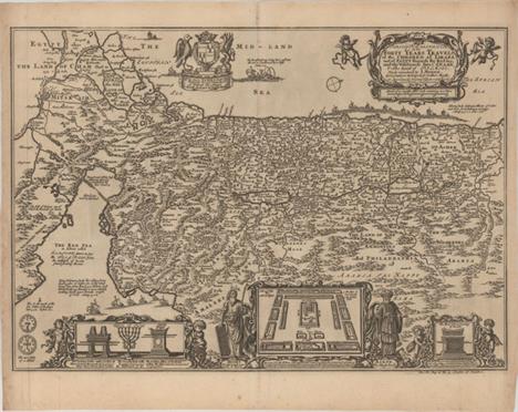
Moxon, Joseph 1671 Israels Peregrination, or the Forty Years Travels of the Children of Israel Out of Egypt Through the Red Sea, and the Wilderness into Canaan, or the Land of Promise This map shows the Palestinian and Lebanese coast and depicts the Jews` passage through the Red Sea and the Sinai Desert. North is oriented to the right. At the bottom are vignettes displaying the encampment of the tribes flanked by Aaron and Moses as well as Temple vessels held up by putti. Originally by Nicolas Visscher, the map was translated into English by Joseph Moxon. 18"" W x 12.4"" H There is a printer`s crease at top left and light toning along sheet edge at left.

Bachiene, Willem Albert 1749 Afbeelding van `t Land van Israel, Naar Deszelfs Natuurlyke Gesteltheid This attractive map from a large Dutch Bible shows the land of Israel with all the places, rivers, mountains, and seas mentioned in the Holy Scriptures. It covers all of Palestine on both sides of the Jordan River and the Mediterranean coastline from Tzor (Sur) to Rhinocolura (El Arish). At bottom is a lovely pastoral scene with Moses standing on Mount Nebo overlooking the land that God forbade him to enter. Engraved by Jan van Jagen. 15.2"" W x 19.4"" H A clean, watermarked sheet with light toning along sheet edges.

Braun & Hogenberg, 1572 Hierosolyma, Clarissima Totius Orientis Civitas, Judae Metropolis This interesting engraving contains two bird`s-eye views of the city; one an imaginary view as it was during the time of Christ and the other contemporaneous to the 16th century. The view on the left also portrays the procession of Jesus to Golgotha, with Judas hanging from a tree outside the city walls. Each has a key to important buildings and places. At lower right is a vignette of Moses receiving the Commandments and a table identifying the garments and accoutrements worn by Aaron. Latin text on verso. 19.3"" W x 13.5"" H There is minor soiling confined to the blank margins and two holes only visible when held to light: a minute hole to the left of the lower centerfold and a small hole in the upper border.

Munster, Sebastian 1541 Tabula Asiae III This woodblock, Ptolemaic map covers the region between the Black and Caspian Seas. The map is divided into three regions: Colchidis, Albania and Armenia. A large gate (Portae Albaniae) is shown in the mountains at the top of the map. This reflects the legend of Alexander the Great, who is said to have discovered the evil hordes of Gog and Magog in this region. Alexander, calling upon the power of God, moved the mountains together and built a mighty wall spanning the entire Caucasus range, closing off the civilized south from the forces of darkness. Noah`s Ark is shown in the Caspian Sea. Woodblock illustration with the title Tertia Asiae on verso. 13.3"" W x 10.5"" H A clean, bright example with light show-through of text on verso and three archivally repaired tears confined to bottom blank margin.

Bellin, Jacques Nicolas 1750 Suite de la Carte de la Siberie et le Pays de Kamtschatka pour l`Histoire Generale des Voyages A fine map of eastern Siberia above and below the Arctic Circle, showing the Sea of Okhotsk, the Kamtschatka Peninsula, and Sakhalin Island. The map depicts Russia`s northern coastline along the Arctic Sea, and shows the tracks of an exploratory voyage to Kamtschatka made in 1648 by three Russian ships. The land is filled with rivers and mountain ranges, with a few cities, towns, and regions identified. A decorative title cartouche in top right containing leaf, flower, and scroll motifs adorns the map. 10.3"" W x 9.5"" H A nice impression with some light toning in the blank margins.

U.S. War Department, 1904 Map of Korea and Manchuria Prepared by the Second Division, General Staff (Military Information Division)... This large, highly detailed map covers the scene of the conflict during the Russo-Japanese war, which was considered the first major war of the 20th century. It is filled with hundreds of place names, roads and communication cables on both land and sea. Includes insets of Port Arthur and Vladivostok with an index map at bottom. Prepared by the War Department and published as a supplement to the March 1904 issue of the National Geographic Magazine, shortly after the conflict broke out. 33.8"" W x 39.3"" H Issued folding with a narrow right margin, several small splits at fold intersections, and some occasional light toning.

Blaeu, Johannes 1655 Suchuen, Imperii Sinarum Provincia Sexta The second landmark in the European mapping of China was the appearance of the Novus Atlas Sinensis in 1655. It was compiled by Father Martino Martini, an Italian Jesuit and produced by the most prominent Dutch cartographer of the time, Johannes Blaeu. Father Martini compiled the work based on Chinese sources between 1643 and 1650, and it greatly advanced European knowledge of the region including the astronomical positions of many cities and topographical features. It remained the standard geographical work on that country until the publication in 1737 of D`Anville`s Atlas de la Chine. This map of the Suchen province is decorated with two particularly graphic cartouches. The scales are flanked by mythical woodwose who represent the mighty Yangtze River, and a warlord and his guard stand behind the title cartouche. 19"" W x 15.7"" H Dark impression and wide margins with a few tiny centerfold separations and some light, uneven toning.

Brue, Adrien Hubert 1821 Carte Generale de l`Empire Chinois et du Japon Beautifully engraved and highly detailed map that shows the size and breadth of China to include Taiwan (Formosa) and extends to include Korea and all of Japan. Filled with watershed and topographical detail, the map also locates the Great Wall and scores of towns. Names the Straits of Korea, but calls the sea between the two countries the Sea of Japan. Brue`s embossed stamp with fancy lettering and flourishes embellishes the title. A decorative keyboard-style border surrounds the map. 20.3"" W x 14.4"" H This example has wide margins and original outline color with some light offsetting and toning.

Homann Heirs, 1750 Et des Rojaumes de Coree et de Iapan This is the eastern half of a two-sheet map of northern Asia, depicting northeastern China, Korea and Japan. There is great detail throughout of towns, political divisions, rivers and topography. There is particularly good detail throughout Korea, based on Jesuit missionary surveys. Two islands appear between Honshu and Sakhalin, following the mistaken discoveries of Maerten Gerritsz Vries in 1643. 15.6"" W x 19.8"" H A nice impression with original color and light soiling. There are two tears and a centerfold separation that enter 1-2"" into map at bottom that have all been closed on verso.

Duval, Pierre 1682 Isles du Iapon This little map is important in the cartographic history of Japan because it presents a new form in the evolution of the European mapping of Japan. Duval altered the Blancus/Moreira type by changing Lake Biwa into a wide gulf, while Kyushu appears as a very rugged narrow island and Honshu takes on an exaggerated mushroom shape. This cartography was copied by several other cartographers, particularly in pocket atlases. This is a later state of the map with Korea acknowledged as being a peninsula. Pierre Duval was Nicolas Sanson`s nephew and pupil. He published a wide range of atlases and individual maps including a fine miniature world geography with many of the maps based on Sanson. 4.9"" W x 3.9"" H A nice impression on watermarked paper with attractive old color that has been partially refreshed and light toning along centerfold and sheet edges.

Zatta, Antonio 1785 L`Impero del Giapon Diviso in Sette Principali Parti This detailed map of Japan is divided into seven principal provinces and depicts numerous towns, mountains, and rivers. The map represents typical European cartography of the late 18th century, with a misshapen Honshu and an elongated Lago d`Otis (Lake Biwa). The map is adorned with a decorative title cartouche with potted plants and a parasol. Engraved by G. Pitteri. 15.5"" W x 12"" H Original color on watermarked paper with light toning and scattered foxing.
![Ptolemy/Fries, 1535 [Title on Verso] Tabula XI Asiae This is a slightly reduced version of Waldseemuller`s Ptolemaic map dra](http://lot-images.atgmedia.com/SR/36385/2901770/678-201425155443_468x382.jpg)
Ptolemy/Fries, 1535 [Title on Verso] Tabula XI Asiae This is a slightly reduced version of Waldseemuller`s Ptolemaic map drawn on the typical conical projection set in a trapezoidal frame. It illustrates the Ptolemaic concept of Malaya and Indochina, labeled India Extra Gangem or India beyond the Ganges. The map shows an oddly shaped Malaysian peninsula, labeled Aurea Chersone (Golden Peninsula) to the east of the Ganges. The Golden Peninsula was thought to be the location of Ophir, the mysterious source of Solomons gold. The China Sea (Sinus Magnus), with yet another completely spurious landmass, is to the east of that. The map hints at the Ptolemaic concept of a landlocked Indian Ocean, in which there are several large islands. Latin text on verso, surrounded by elaborate woodcut decorations. 16.1"" W x 11.3"" H A nice impression with wide, original margins, very minor soiling, and expert paper repairs along centerfold. Light show-through of text on verso.

Anson, George 1749 Plan de la Baye de Manille This attractive chart of Manila Bay comes from a French edition of Anson`s Voyage Around the World. Anchorages, soundings, and rocks are indicated in the water, and several places are named along the coast, including Bataan, Metro Manila, and Cavite. A fleur-de-lis orients the north to the left. 9.9"" W x 8"" H Issued folding on watermarked paper with light printer`s ink residue, faint offsetting from an opposing page of text, and a tiny infilled hole.

Duval, Pierre 1682 Isles de la Sonde This miniature map covers Malaysia, Borneo, Java and Sumatra and depicts major towns and islands. Sincapura (Singapore) is prominently named at the tip of Malaysia. Pierre Duval was Nicolas Sanson`s nephew and pupil. He published a wide range of atlases and individual maps including a fine miniature world geography with many of the maps based on Sanson. 4.9"" W x 3.9"" H A nice impression with attractive color on watermarked paper and light toning along the centerfold.

Apres de Mannevillette, Jean B. N. D. 1775 Carte de la Baye et du Port de Trinquemalay dans l`Isle de Ceylan This detailed nautical chart depicts the Bay of Trincomalee, a strategic seaport in the international trading history of Sri Lanka located on the northwest coast. The chart is fully engraved with great detail of the coastline and countless soundings, and features a legend identifying 23 locations, a compass rose and two views of the coastline. Columns of French text at left give detailed sailing instructions. Engraved by Guillaume Delahaye. 26"" W x 19.3"" H A nice impression on a bright, watermarked sheet with light offsetting, minor toning along the centerfold, and two tiny worm holes. There is a damp stain at bottom of sheet at centerfold, just entering neatline.

Sanson/Mariette, 1654 Partie Meridionale de l`Inde en Deux Presqu`Isles, l`une deca et l`autre dela le Gange This map of southern Asia is divided into kingdoms and extends from India in the west to Sumatra and Borneo in the east. The mountainous topography of the region is depicted, and there are numerous place names along the coasts. Adorned with a decorative title cartouche, floating in water. Engraved by J. Somer. 20.5"" W x 14.8"" H Original color on watermarked paper with light toning along the centerfold, a few tiny rust spots, and a couple of small damp stains confined to the blank margins.

Bellin, Jacques Nicolas 1752 Carte de l`Inde en Deca du Gange Comprenant l`Indoustan &c. Suivant les Cartes les Plus Recentes... This map depicts the northern section of the Indian subcontinent and includes present-day Pakistan, Afghanistan, Nepal, and Tibet, in addition to northern India. It features regions, towns and cities, rivers, topographical detail, and a few geographical notes, and is adorned with two cartouches, containing the title and distance scales, respectively. 13.5"" W x 9.1"" H Issued folding with light scattered foxing and a hint of toning.

Langenes, Barent 1598 Africa This map of Africa is interesting for its strange depiction of the Nile, which originates in a large lake south of the Equator. From this lake three large rivers flow to the seas: the Nile to the Mediterranean, the Congo to the Atlantic and what could be the Zambeze to the Indian Ocean. This map is based on the Gastaldi-Ortelius and Mercator models, although it includes the unique feature of a lake along the Equator into which both the two Ptolemaic lakes flow. The sea is engraved in a moiré pattern, and the map is further decorated with a strapwork title cartouche and three sea monsters, including a sea ""lion."" Though not signed, this map was likely engraved by either Jodocus Hondius or Petrus Kaerius, who engraved the majority of the maps of the Caert-thresoor (Map Treasury). This is the scarce first state without degrees of latitude in the borders, published by Cornelius Claesz and printed by Langenes. Dutch text on verso. 4.9"" W x 3.5"" H There is light soiling, minor show-through of text on verso, and a couple of minute worm holes only visible when held to light.

Bertius/Tavernier, 1627 Carte de l`Afrique... Although the title cartouche credits Petrus Bertius, this map was created by Melchoir Tavernier, and was derived from Hondius` influential maps from 1619 and 1623 (as was Bertius` map from 1624, hence the attribution). The geography is typical for the 17th century and is filled with spurious rivers, mountains and kingdoms. The map is embellished with a variety of exotic animals in the interior, including elephants, ostriches, lions, and even a dragon. The seas are filled with ships, Neptune with his consort, flying fish, and sea monsters. This map was published by Tavernier as part of a set of the four continents. This is the first state. 19.9"" W x 15"" H A fine impression with superb color on watermarked paper with a few light spots of foxing and a professionally repaired tear that just enters map border at bottom left. Very nearly an ""A"" example.

Duval, Pierre 1682 Afrique Charming small map of the continent with typical mid-seventeenth century cartography. The Nile rises from large twin lakes below the equator. This is the third state, with the addition of several place names: the island of S. Helene la Nouvelle and Gothar just below the equator in central Africa. Pierre Duval was Nicolas Sanson`s nephew and pupil. He published a wide range of atlases and individual maps including a fine miniature world geography with many of the maps based on Sanson. 4.9"" W x 4.1"" H Attractive color on watermarked paper with light toning along the centerfold.

Heylin, Peter 1703 Africa ""This rare map of Africa depicts some unusual interior cartography. The Nile originates in Abyssinia but the large Ptolemaic lakes, Zaire and Zaflan, are retained. But instead of spawning the Nile River, the Zebee River flows into them from the north while the Zaire, Zembeze and several other rivers flow out to the west and south. Numerous kingdoms are located throughout. The title is contained is a small strapwork cartouche. Peter Heylin was a noted geographer and cosmographer who was also Chaplain to King Charles I of England. He wrote Microcosmus, or a Little Description of the World in 1621 which was later expanded into his Cosmographie, published from 1652 into the early 18th century."" 16.5"" W x 14"" H Watermarked paper with light toning along the centerfold and a printer`s crease at top. There are several worm tracks that have been professionally infilled and a few tiny wormholes only visible when held to light.

Brion de la Tour/Desnos, 1766 L`Afrique Dressee pour l`Etude de la Geographie... Handsome continental map decorated with a pictorial title cartouche and several ships under full sail. The interior of the map contains little geographical information, as is typical of the period. Large rivers are evident but the larger lakes are not marked. The Nile flows from two small lakes, located in the Mts. de la Lune above the equator. In the south there is a minimum of place names and a few tribal names. Brion was the former Geographer to the King of France, and Desnos was Geographer to the King of Denmark. This edition is exactly the same map as described by Norwich but has a slight variation on the highly decorative surrounding border. A separate plate was used to print the border. 12.3"" W x 11.1"" H A few light scattered spots and very minor toning along the centerfold.
![Thomson, John 1817 North Africa [on sheet with] South Africa Two maps on one sheet detailing northern and southern Africa. T](http://lot-images.atgmedia.com/SR/36385/2901770/726-201425155622_468x382.jpg)
Thomson, John 1817 North Africa [on sheet with] South Africa Two maps on one sheet detailing northern and southern Africa. The top map covers north Africa`s Mediterranean coast and extends to include all of the Red Sea in the east and the Gulf of Guinea in the west. The map shows the areas of Morocco, Algeria, Libya, and Egypt, as well as the Sahara and Libyan deserts and the Mountains of the Moon. The bottom map depicts the southern tip of Africa divided into the districts of Stellenbosch, Zwellingdam, and Graaf Reynet. Both maps are filled with interesting details indicating the locations of caravan routes, cannibal tribes, cave paintings, ""good water,"" and historical events. 20.2"" W x 23.1"" H Original color with some light offsetting, a tiny abrasion in the upper map, and two small edge tears that do not enter map image.
![Ptolemy/Fries, 1535 Libyae Interioris Pars [Title on Verso: Tabula III Aphricae] This stunning, Ptolemaic map covers eastern](http://lot-images.atgmedia.com/SR/36385/2901770/727-201425155624_468x382.jpg)
Ptolemy/Fries, 1535 Libyae Interioris Pars [Title on Verso: Tabula III Aphricae] This stunning, Ptolemaic map covers eastern Libya, Egypt and the Nile Delta in considerable detail with the characteristic rope-like mountains and exaggerated rivers. The map is a slightly reduced version of Waldseemuller`s similar map of 1513. This edition was printed by Melchior and Gaspar Trechsel, and edited by Michael Servetus. The verso has Latin text with elaborate wood cut panels flanking it, which are said to be the work of Hans Holbein. 17.8"" W x 11.8"" H A dark impression with some light creasing along centerfold and archival repairs to several worm tracks along the centerfold, with a minute amount of image replaced in facsimile.

Duval, Pierre 1682 Egypte A charming miniature map of Egypt, extending south to Quesir (Cossir). The pyramids are depicted just south of Giza. Pierre Duval was Nicolas Sanson`s nephew and pupil. He published a wide range of atlases and individual maps including a fine miniature world geography with many of the maps based on Sanson. 4.1"" W x 5"" H A nice impression on watermarked paper with attractive old color that has been lightly refreshed and light toning along centerfold and sheet edges.
![Thomson, John 1817 Egypt [on sheet with] Abyssinia Two maps on one sheet. The left side shows a portion of Egypt along the N](http://lot-images.atgmedia.com/SR/36385/2901770/736-201425155644_468x382.jpg)
Thomson, John 1817 Egypt [on sheet with] Abyssinia Two maps on one sheet. The left side shows a portion of Egypt along the Nile river from Luxor to the Mediterranean Sea. A slightly larger map at right shows Ethiopia with the tracks of various explorers displayed in outline color with an index at bottom. Both maps have various notations about natives and explorers and show basic detail of topography and place names. 23.4"" W x 19.4"" H Original color with a few light stains and minor offsetting.

1869 The Illustrated London News No. 1529. - Vol. LIV... This issue of The Illustrated London News was published March 13, 1869, and features two maps, four engravings, and an in-depth article focused on the Suez Canal, then under construction. The first map, Plan of the Harbour of Port Said, and the Mediterranean Entrance of the Canal (5.0 x 6.1""), is a detailed plan of the northern terminus of the canal, locating various basins and other sites of interest, including the famous Light-house of Port Said, which would have been in progress at the time. Below this plan is the second map, Plan of the Maritime Canal, with the Small Fresh-Water Canal (9.3 x 3.5""), which zooms out and shows the entire length of the canal and its surroundings. In addition to these maps, four striking engravings are included that provide a glimpse into the region: The Isthmus of Suez Maritime Canal: Workmen Loading Dromedaries (9.4 x 8.1""); The Isthmus of Suez Maritime Canal: Breakwater at Port Said, and Mediterranean Entrance to the Canal (13.5 x 9.6""); Lake Menzaleh (9.4 x 6.0""); and The Pelusian Plain (9.4 x 5.9""). The magazine contains several other engravings, including a portrait of the newly elected President Ulysses S. Grant and a full page showing helmets and shields on display at the Great Exhibition Palace in South Kensington at the time. 11.3"" W x 15.8"" H Clean and bright, with one sheet loose from the original string ties and minor extraneous creases on a few pages.
-
534297 item(s)/page