

Wilkes, Charles 1844 Atlas. Narrative of the United States Exploring Expedition. During the Years 1838, 1839, 1840, 1841, 1842 "This is the atlas volume from the very rare first edition of the Wilkes` Expedition (with only 100 copies printed) that accompanies Wilkes` five volume narrative of the Exploring Expedition, which was one of the most important American scientific expeditions of the 19th century. It was the first U.S. Naval expedition, taking in the Northwest Coast, Hawaii, South America, the Philippines, the South Pacific, Australia and Antarctica. The expedition broke new ground in most areas of natural history and made a number of extremely important cartographic discoveries, most importantly establishing that Antarctica was a continent. They mapped 280 islands in the Pacific for the first time and included extensive and graphically rich ethnographic records of many native peoples throughout the Pacific. The five maps included in this volume are: “Map of the Oregon Territory...”., dated 1841, black & white (33.8 x 22.8”). An important map that Wheat says is “really quite extraordinary” and in many respects was the most detailed yet published. The map covers the entire region west from the Black Hills, north to above the 50th parallel and south to the Sacramento River. The United States Exploring Expedition did not enter the Great Basin or any part of the Snake River basin. Instead Wilkes relied on other sources including Jedediah Smith and oral information from Hudson Bay trappers he met on the Columbia River. Although the map contains several errors, the areas of today`s Oregon, Washington and Idaho are remarkably well mapped. According to Wheat the map had much influence on later maps of this region. It was a major contribution to American cartography and the most detailed map of the region north of the Sacramento River. Wilkes supported the view of Senator Lewis Linn that the boundary of the American claim should be 54° 40` N, commonly referred to as “Fifty-Four Forty or Fight” dispute with Britain. This map was used to support his claim, which was based on `topographical` grounds and was instrumental in setting the scene for American interests in the territory. Includes a large inset of the Columbia River from Ft. Walla Walla to its mouth, where one of Wilkes` ships, the “Peacock”, was lost on the famous Columbia Bar. This map is considered one of the more important maps of the Northwest region after the Lewis & Clark expedition. “Chart of the Antarctic Continent Shewing the Icy Barrier Attached to it...”, dated 1840, black & white (34 x 23.5”). This map represented a major advance in establishing Antarctica as a true continent, thus helping to settle the cartographic mystery of its existence which had been debated by explorers and mapmakers for centuries. It is a detailed map of Antarctica and the southern Pacific Ocean centered on the longitude of Van Diemens Land. It shows Antarctica from about longitude 95° West to 170° with surprisingly good detail along the coastline. Numerous Ice Islands clog the bays and seas near land and many air and water temperatures are noted. The tracks of the ships Vincennes, Peacock, Porpoise, and Flying Fish are detailed. At upper left are five sea approach views. “Chart of the World Shewing the Tracks of the Exploring Expedition in 1838, 39, 40, 41 & 42...”, circa 1844, hand color (32.2 x 23.3”). This detailed map shows the tracks of the Expedition vessels along with the direction and velocity of ocean currents and trade winds. Isothermal lines are delicately colored to indicate water temperature in five degree groupings. “Map of Part of the Island of Hawaii Sandwich Islands Shewing the Craters and Eruption of May and June 1840...”, dated 1841, black & white (23.6 x 15.3”). This map depicts two volcanic mountains visited by the Expedition and includes the track of the party to the crater of Moku-a-weo-weo on the top of Mauna Loa. “Chart of the Viti Group or Feejee Islands...”, dated 1840, black & white (33.8 x 23.5”). Shows very good detail of the 154 islands in the group including coastlines, coral reefs, and topography by hachure. Hardbound in brown cloth over boards. Printed by C. Sherman in Philadelphia." 9.8" W x 13.5" H The maps are generally good with light toning and offsetting. The colored map of the world has two moderate splits at fold junctions and a separation at bottom that enters 5.75" into the map image, while the map of Hawaii has a separation at bottom that enters 1.25" into the image. The spine has perished (this is not the original binding), the covers are detached, and the front endpapers and title page loose.
We found 534325 price guide item(s) matching your search
There are 534325 lots that match your search criteria. Subscribe now to get instant access to the full price guide service.
Click here to subscribe- List
- Grid
-
534325 item(s)/page

Anon., 1759 The Gentleman`s Magazine, and Historical Chronicle "This lot includes 9 individual monthly issues (missing May, October and November) and the supplement from 1759 during the heart of the Seven Years War. All maps and plates are present for the monthly issues included. The eight maps, all listed in Jolly, include: A. “Compleat Map of Germany Comprehending in One View the Different Seats of the Present War” (11 x 13.3”). B. “A Map of Martinico, from the Latest and Best Authorities”, by John Gibson (7.5 x 9.5”). C. “The Roads, of Toulon, with the Adjacent Country” (8 x 10.5”). D. “A Map of the Seat of War on the Rhine, and Part`s Adjacent, in Germany, 1759” (7.3 x 10”). E. “A New and Accurate Map of the Isles of Guadaloupe, Marie-Galante &c. from the Best Authorities”, by John Gibson (4.8 x 11.5”). F. “Plan of Have de Grace [on sheet with] The Bombardment of Have de Grace July 4th 1759 [and] [Untitled - English Channel]” (7.5 x 10”). G. “A Map of That Part of Westphalia, in which the French Army Where [sic] Defeated Aug. 1. 1759” (4.3 x 7.3”). H. “A Map of Pomerania and Brandenburg with the Frontiers of Poland” (7.5 x 10.3”). Disbound, 8vo." 5.3" W x 8.3" H The maps and plates are good to very good with light to moderate toning and occasional light offsetting. Disbound.

Origenis. Dialogus Contra Marcionitas. sive de recta in Deum fide. opera & studio M.Joh Rodolfi Wetstenii. pub. Basileae, Bertischius. 1674. 4to. bound in original full leather. Pp. 231 plus complete index. Light worming in a few margins and final leaf of an addenda missing, and two other antiquarian. (3)
Six Trade Catalogues in lighting, including Garfield Electrical Supply Co, Decorative Lighting Fixtures, HARCOURTS, Lighting Equipment, METRO-VICK SUPPLIES, Electric Light Fittings, 1930`s, HENLEY TELEGRAPH WORKS, Henleu Overhead Transmission, Industrial Lighting, First Edition and T CLARKE & CO, Electric Light Fittings Catalogue 1928 (6)


A PAIR OF EDWARDIAN SILVER CANDLESTICKS WITH ELECTROPLATE CANDELABRA BRANCHES, THE STICKS GOLDSMITHS & SILVERSMITHS CO LTD, LONDON, 1906 oval outline, reeded borders, loaded sticks with detachable nozzles, two-light branches each with deep U-shaped arms flanking a beaded cone finial on tall slender leafy stem, 47cm high overall

OPAL, DIAMOND AND ENAMEL BROOCH designed as a peacock, the breast collet-set with a pear-shaped cabochon opal with single-cut diamond wings, the tail plumage decorated with circular-cut diamonds and blue and green enamel ++Opal measures 19.4mmx12.5mm. Blue/green colour with some red/brown matrix, natural indentations but little obvious wear. Larger diamond by beak measures 4.7mmx4.7mmx3.0mm (0.4 carats, clarity Vs in collet setting, colour I/J). Other large stone measures 5mmx5.1mmx3.5mm (0.5 carats, clarity I2, colour M-O). Other stones weigh a total of 0.4 carats (not including single cuts). The blue enamel is worn particularly towards the edge and there are some small bubbles in the green only seen with close magnification. Reverse gold has some light wear, stamped 750 for 18 carat gold. In good condition.

GOLD FRINGE NECKLACE, 1960s designed as an articulated row of fluted lozenge links, graduated to the front, Italian gold marks for Vicenza 1944-1970, stamped 585 approx. 410mm long, 24.5gr ++Very well articulated necklace. Light wear. 585 stamped to clasp for 14 carat gold. In good condition.


William III to William IV, silver coins: crowns, 1696 OCTAVO, some flaws above head on obv. & light graffiti to both sides, 1821 SECUNDO (3) & 1822 SECUNDO, fine, halfcrown, 1817, three minor cuts below bust, shillings, 1697, worn rev., 1739 roses, 1816 & 1817, both with some discolouration & pitting, 1820, 1826 (2), one possibly sometime gilded & 1829, sixpences, 1711, 1746 LIMA, good fine, 1787, without hearts, very fine, 1816 (3), inc. one fine & one scratched & 1831, threepence, 1762, extremely fine, toned, fourpence, 1836 & Maundy penny, 1831, almost uncirculated & proof-like, others mainly fair, unless stated (24)

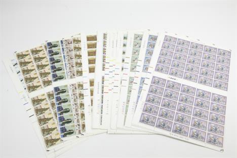
GB, EII, pre-decimal stamps, inc. full sheets (33) & half sheets (6), mainly with traffic light borders, quantity of part sheets, blocks, strips & singles, inc. five shilling, castles, in block of twenty & four, with some other definitives, a few sheets with damaged, folded or creased borders or some tears to perforations, otherwise unmounted mint (lot)


Antique cameo bar brooch, approx. 35mm long, comprising oval carved shell, approx. 15mm x 12mm, depicting the head portrait of a lady, oval frame with light ornate pattern, in centre of a slim bar with ball finials, frame tested 18ct gold, bar tested 9ct gold, slight damage to the cameo under the head, 3 small splits in gold frame & solder marks to pin (gross 3.5g)

Gent`s antique silver pocket watch, key wind, not working, white dial, approx. 42mm, seconds dial & black Roman numerals, some slight damage to dial, no seconds finger & the hour hand is missing, back case with light engine turned pattern & garter shield cartouche to centre, h/m Birmingham 1890


A pair of Elkington & Co. gilt and champlevé enamel flared vases, c.1875, decorated in repeating Persian designs with yellow flowerheads within scrolling leaves and pointed arched panels on a light blue ground, stamped ELKINGTON & CO 12109, 19.7cm (2) CONDITION REPORT: One vase has a slightly mishapen rim. There is some deterioration to the gilt finish, especially the interior which is scratched and marked. Loss to enamels, mainly to the bodies, some relatively large losses (some of which show the base metal through). Also some darker areas of restored enamel that have probably been added to earlier losses. Small dents to base and foot rim.

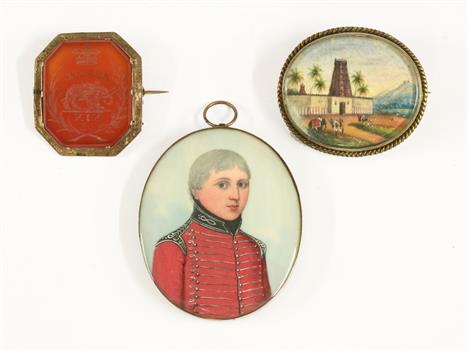
English School (c.1815), PORTRAIT OF CAPTAIN THOMAS MARTIN, 19TH LIGHT DRAGOONS oval miniature, hung in a gilt wood oval frame 6 x 5cm with written label 'Fought at the Battle of Assaye (1803), was ADC to Lord Lane', together with an intaglio 'Assaye' cornelian brooch, and an Indian miniature brooch (3) CONDITION REPORT: No cracks. Gilt frame has many cracks in the gesso. Gilt mount dirty and needs replacing. Not inspected out of frame.
-
534325 item(s)/page