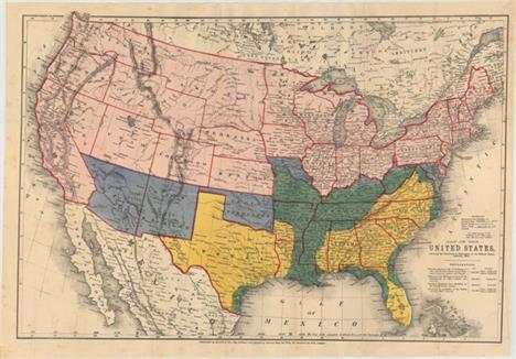

Bacon, G. W. & Company, 1864 Map of the United States, Showing the Territory in Possession of the Federal Union This is an unusual Civil War map in that it gives information on territorial claims, both by the Confederate States and the Federal Union, including areas reclaimed from the Rebellion. The depiction of the Western Territories is particularly interesting. A large Dakota extends all the way to the Rockies bordering Washington and two offset rectangles make up the newly formed Idao - an unusual configuration for Idaho. A table below the title gives the population, both free and slaves, of each color-coded area. 26.4"" W x 17.7"" H Issued folding with light scattered foxing and an edge tear at right that extends 3.5"" into the image closed on verso with archival material.
We found 534297 price guide item(s) matching your search
There are 534297 lots that match your search criteria. Subscribe now to get instant access to the full price guide service.
Click here to subscribe- List
- Grid
-
534297 item(s)/page
![U.S. Geological Survey (USGS), 1884-99 [Lot of 3] Map of the United States Exhibiting the Progress Made in the Geographic Su](http://lot-images.atgmedia.com/SR/36385/2901770/154-20142515389_468x382.jpg)
U.S. Geological Survey (USGS), 1884-99 [Lot of 3] Map of the United States Exhibiting the Progress Made in the Geographic Survey [and] Map of the United States Showing Progress in Preparation and Engraving of Topographic Maps [and] Map Showing Condition and Progress of Topographic Surveys ""These three maps show the evolution of surveying by the USGS over a fifteen-year period (1884-1899) including: A. Map of the United States Exhibiting the Progress Made in the Geographic Survey, from Fifth Annual Report, dated 1884 (28.3 x 17.4""""). Surveying is focused on the western states including Colorado, Utah, Nevada and California. The legend shows four different surveys: Triangulation, Area Surveyed by Geological Survey, Area Surveyed by Northern Transcontinental Survey, and Area Surveyed by other Organizations. Condition: There is some light color offsetting and some extraneous creasing at left. (B+) B. Map of the United States Showing Progress in Preparation and Engraving of Topographic Maps, from Seventh Annual Report, circa 1886 (28.3 x 17.3""""). Depicts the extent of surveying at the close of the fiscal year 1886. Surveyed areas include the southern Appalachians, the Great Basin, California and Washington state. Condition: There is a small stain in Nevada at the fold and a binding trim at lower left. (B+) C. Map Showing Condition and Progress of Topographic Surveys and Location of Gaging Stations for the Fiscal Year 1898-1899, from Twentieth Annual Report, circa 1899 (28.2 x 17.4""""). Additional surveying is seen especially in the middle of the country in Kansas, Missouri and Oklahoma. Gaging stations are also identified. Condition: A clean, bright example. (A)"" "" W x "" H See descriptions above.

Rand McNally & Co., 1893 The Rand-McNally Railway Guide Map of the United States with Portions of the Dominion of Canada, the Republic of Mexico, and the West Indies This very large and detailed map of the United States features terrific railroad detail along with towns, cities, rivers and topography. It extends to include most of Mexico and southern Canada. Advertisements surround the map including one for the Everett Land Co., which is the terminus of the Great Northern Railroad. At bottom is an inset of Alaska showing no railroad development. The verso contains numerous advertisements. The map appears to have been issued with paper covers but none are present. 42.5"" W x 30.5"" H The map is mostly clean and bright with light toning along a couple of folds, very faint offsetting in a few spots, and short splits at fold intersections closed on verso with archival tape.

Brion de la Tour, Louis 1784 Carte des Etats-Unis d`Amerique et du Cours du Mississipi The Treaty of Paris, which ended the Revolutionary War, brought on the publication of a number of maps of the new United States and this map was among the earliest French maps to show the new nation. First published in 1783, this is the second state, dated 1784, but apparently unchanged from the first state. The map shows the nation`s boundary on the Mississippi River, but extends to include considerable information on the Indian tribes on the western frontier as far as present-day Kansas (Kanfez). The states of Virginia, North Carolina, South Carolina and Georgia all have their western borders on the Mississippi River. There is excellent detail of early settlements, forts, and Indian villages with a list of 18 important forts in the New England region. A table at lower left gives the population for the original 13 states. A section of Virginia is named Indiana. This region was originally granted to a Philadelphia trading company by the Iroquois Confederacy in 1768. Then in 1776 it was sold to the Indiana Land Company, but was also claimed by the State of Virginia as a part of her original charter. The resulting battle between the private land company and Virginia resulted in the Eleventh Amendment to the U.S. Constitution and is one of the most interesting chapters in the history of the young United States. The large title cartouche is framed by a Liberty cap on a pikestaff, emblem of the Sons of Liberty, and the flags of the United States and France. 27.5"" W x 20"" H Nice impression and original color on sturdy, watermarked paper. There is a faint horizontal extraneous crease where the map was folded, a few small spots in the image, and light toning primarily confined to the lower blank margin.

Scott, Joseph 1800 The United States of America This map of the young United States covers the region from Maine south to Florida and west to the Mississippi River. Georgia`s western boundary extends to include present-day Alabama and Mississippi. Several spurious islands are located in Lake Superior including I. Royal. Vermont is not named. Inland detail is limited to rivers, topography and some place names. The map is accompanied by five pages of related text describing the land, population and trade. 12.8"" W x 10"" H Issued folding and now flattened and professionally backed with tissue to repair and reinforce numerous fold separations and a 5"" edge tear at right. Light soiling.

Tardieu, Antonie Francois 1806 Carte Generale des Etats-Unis This finely engraved map shows the United States extending to the Mississippi River. It extends westward beyond the Mississippi River to show a portion of Louisiana Territory with numerous Indian tribes located on the frontier. The western boundary for Georgia is at the Mississippi River and the oversized Florida is composed of East and West Florida. There is significant detail with a surprising number of towns and settlements located. Published by Chanlaire & Mentelle. 18.7"" W x 14.8"" H On watermarked paper with very light offsetting.

Cummings & Hilliard, 1822 The United States This early folding geological map of the United States is the frontis for ""An Elementary Treatise on Mineralogy and Geology, Designed for the Use of Pupils,"" by Parker Cleaveland, Boston, published by Cummings & Hilliard. The map`s geology is by Parker Cleaveland and was drawn by H. Morse. It extends into Texas to include San Antonio. Contains great watershed detail and uses hand coloring to suggest five or six geologic formations. Marcou says this map is a reissue of the 1817 Maclure`s Geological Map ""with very few additions or variations."" Issued on thin banknote-style paper, it is in the complete volume one (5.5"" x 9"") in tan boards. Second edition, octavo, 480 pp. of text with deckled edges. One of the most famous and widely used mineralogical reference works of the early 19th century in America. Very scarce especially with the map present. 16.5"" W x 11"" H The map has a few minor stains and extraneous creases, otherwise near fine. Text has light toning with some chips to the deckled edges. The spine has nearly perished and the covers are partially detached and worn. Map (B+), book (B).

Vandermaelen, Philippe Marie Guillaume 1825 Amer. Sep. Partie des Etats Unis. No. 51 This finely engraved and extremely detailed map covers the region from just south of the Chesapeake to Long Island, and up to Cape Cod, showing all or part of North Carolina, Virginia, Maryland, Pennsylvania, Delaware, New Jersey, New York and Long Island, Connecticut, Rhode Island, and Massachusetts. There is good detail of the Chesapeake and Delaware Bays and the counties, towns, rivers, roads, mountains, rivers and islands. The map has extensive notes on commerce, government, religion, revenues and weather. A large table gives state by state populations, showing growth by decade for 1790, 1800, and 1810. Expanded details for 1820 include populations for whites, slaves and free blacks, as well as populations of non-citizens, and information on the type of employment, broken down by agriculture, commerce and manufacturing. The second table gives the total populations for Indians by state. The ""Atlas Universel"" contained 400 lithographed maps in 6 volumes. It was the first atlas to present all the maps on the same scale (1: 1,641,836). There was only one edition of this scarce atlas, published in 1825-27, and the subscription list shows that only 810 copies were sold. 22.3"" W x 19"" H Attractive original color with light offsetting primarily confined to the Atlantic Ocean and explanation table.

Hall, Sidney 1829 United States Nice small map with an extended Arkansas Territory that touches the border of Mexico (Texas) with the Red River serving as part of the southern border. The region to the north of Arkansas Territory and lying between the Mississippi River and the Rocky Mountains, with the exception of Missouri, is noted as Western States and contains the names of numerous Indian tribes. Texas is labeled as Mexican Territory. Wisconsin is a large territory that includes today`s Minnesota and extends to the Red River. Inset ""Continuation of Florida"" is on the same scale and locates Key Largo, St. Augustine, Cape Florida, Pt. Tancra, etc. Engraved by Sidney Hall and published by Longman, Rees, Orme, Brown & Green from Paternoster Row, London. 9.3"" W x 7.3"" H Slightly toned with light soiling.

Montanus, Arnoldus 1671 Novi Belgii, quod nunc Novi Jorck Vocatur, Novae qz. Angliae & Partis Virginiae Accuratissima et Novissima Delineatio This finely engraved map is based on the influential Jansson-Visscher series. Geographically the map follows Jansson, including the placement of nearly every European settlement along the coastline and rivers. It covers the Eastern seaboard from just below the Chesapeake Bay to Pennobscot Bay. Most of the interior details appear sketchy and speculative and are occupied by large forests and wild animals. Many of the place names have been revised to reflect the loss of the Dutch colony to the British in 1664. While Nieuw Nederlandt still appears for the region, the city is named Nieu Jorck, the Dutch Fort Organie is named Albany, and Nieu Jarsey is now named. The unique decorative elements shows Native Americans in a variety of occupations. 14.6"" W x 11.5"" H A dark impression with tattered edges at left, right, and bottom, leading to a few short edge tears that enter 1/8"" to 1/2"" into the image and a small portion of missing neatline at top left. There are light damp stains on the right and left edges of the

Salmon, Thomas 1767 New England New York New Jersey and Pensilvania This fascinating map was copied from Moll`s map of the same name, one of the earliest Post Road maps. As in the Moll map, the postal road is shown extending from Portsmouth, New Hampshire along the coast to New York and turning west to the Delaware River. New York is confined to a narrow strip along the Hudson River and New Jersey is divided into West and East New Jersey. Several Indian tribes are noted in Pennsylvania. Nova Scotia is named Scotland. A sea battle rages in the Atlantic. 10.5"" W x 7.7"" H Issued folding, now flattened, with light creasing along the folds. Remargined at top and at right with the majority of the neatline missing. Faint damp stains enter image at bottom and at right, and there are several smaller light stains scattered thro
![Crevecoeur, Michel Guillaume De 1787 [Three Volumes] Lettres d`un Cultivateur Americain Addressees a Wm. S... on Esqr. Depui](http://lot-images.atgmedia.com/SR/36385/2901770/178-201425153852_468x382.jpg)
Crevecoeur, Michel Guillaume De 1787 [Three Volumes] Lettres d`un Cultivateur Americain Addressees a Wm. S... on Esqr. Depuis l`Annee 1770 Jusqu`en 1786... ""This very attractive three-volume set is Crevecoeur`s classic collection of twelve essays that reflected on the nature of American life, particularly its customs and manners. His description of bountiful American lands spurred many French people to immigrate to America. Of special interest, the book contains letters concerning observations of life on the islands of Nantucket and Martha`s Vineyard, which are generally considered to provide the first detailed depictions of these islands. Howes says that Crevecoeur`s work is a: """"Description of American life of great influence in attracting European immigration in the post-revolutionary period. As literature unexcelled by any American work of the eighteenth century."""" The books include the following 5 maps: Carte Generale des Etats de Virginie, Maryland, Delaware, Pensilvanie, Nouveau-Jersey, New-York, Connecticut... (25.5 x 18.8""""). This is an updated edition of Evans` rare and important map of the Middle Colonies that was first published in 1755. Highly detailed, the map covers the frontier, not just the better known populated areas of the states. It extends to include Lakes Ontario and Erie, and the St. Lawrence River to Montreal. The map randomly uses French or English for the scores of place names, while most notations and the legend are in English. A large inset at upper left """"Esquis se duresse de la Riviere de l`Ohio"""" shows the course of the Ohio River to the Mississippi and up to Lakes Michigan and Huron. The French had better knowledge of the Great Lakes area as evidenced by additions on this map not found on the original Evans. For example, the Portage of Chikago, Fort Erie, and St. Louis are shown and the Niagara River valley contains more detail of the watershed in the region. Crevecoeur also included updated information in New England particularly in Vermont, where Dartmouth College, Putney, Bennington & Westminster are located. Kentucky is erroneously named as a state and there are early references to important cities in the region - Louisville, and Leestown, which was the first Anglo-American settlement on the north side of the Kentucky River and is now part of Frankfort. The map names Indian tribes and a legend explains their status: Extinct; Nearly extinct; and those that are Still considerable. Condition: Light offsetting with a binding tear that extends 0.5"""" beyond the neatline. (B+) Carte de l`Ile de Nantucket, pour les Lettres dun Cultivateur Ameriquain (8.0 x 11.0""""). This early copper engraved map of Nantucket includes a legend identifying thirty-two different sites. In addition to the detail in the legend, the map locates Sherburn, Full Mill and Isle de Tuckanuck. Condition: Faint offsetting. (A) Carte de l`Ile de Martha`s Vineyard avec ses Dependances... (10.3 x 8.3""""). This rare copper engraved map covers Marthas Vineyard, the Elizabeth Islands and a portion of Cape Cod. On the Vineyard, details include roads, natural features, towns and villages, and two meeting houses. Also locates Tidsbury Wood Land south of Tidsbury Town, Eel Pond, Peat Swamp, Squidnoket Pastures, and Cape Pog Pond. The legend at upper right identifies ten features on the map with more information. A most desirable and early map of Martha`s Vineyard. Condition: Light offsetting. (A) Esquisse du Muskinghum [on sheet with] Esquisse du Sioto [and] Esquisse de la Riviere du Grand Castor (20.5 x 9.0""""). Interesting sheet that contains three separate maps showing the Indian villages in the region of the Ohio River. At upper left above neatline is """"Tome IIIme. Page 413."""" Condition: Light offsetting. (B+) Carte Generale des Etats-Unis de l`Amerique Septentrionale... (16.7 x 10.1""""). An uncommon map of the early United States and the first printed map to name Frankland. Also known as Franklinia, it is shown here just west of the border of North Carolina, named Pays de Frankland. In 1785 settlers in western North Carolina and what would become eastern Tennessee organized a state government to be named in honor of Benjamin Franklin. Congress turned down their appeal but the state maintained a legislature and governor until 1788. This ephemeral state appears on only a small number of maps. The 14th state of Vermont is named and noted in the key at right, with a notation in French that it was """"not yet accepted in the confederation."""" Virginia is shown in a strange configuration and there is a square-shaped region denoted as Pays de Kentukey. Condition: There is a short binding tear at right with a small area of loss along the right neatline not impacting the map image. Light offsetting and toning along one fold. (B+) All maps are engraved by Pierre Tardieu. Matched set in three volumes - volume 1 (478 pp.), volume 2 (438 pp.), volume 3 (592 pp.). Octavo, hardbound in original full calf with gilt title on red and green labels on the spine, marbled endpapers and marbling on the sheet edges. A very attractive offering."" 5.1"" W x 8.1"" H An overall very nice example. Contents are generally clean and tight and the binding shows only minimal wear. See description above for the condition of the maps.

Morse, Jedidiah (Rev.) 1796 Rhode-Island and Connecticut This early map of Rhode Island and Connecticut was published in Morses The American Universal Geography. The map depicts counties, townships, rivers and numerous small lakes and ponds. In the west the Oblong is shown, which was a 2 by 50 mile stretch of land given to New York in return for Connecticuts boundary extending westward along Long Island Sound. Drawn by Harding Harris and engraved by Samuel Hill. 13.2"" W x 7.7"" H Issued folding and now flattened with a few minor spots and light toning along one fold.
![U.S. Coast & Geodetic Survey, 1890 [Map in Report] Notes on an Early Chart of Long Island Sound [with] A Portion of a Ma](http://lot-images.atgmedia.com/SR/36385/2901770/182-201425153859_468x382.jpg)
U.S. Coast & Geodetic Survey, 1890 [Map in Report] Notes on an Early Chart of Long Island Sound [with] A Portion of a Map of New England in the Public Record Office This rare and separately bound paper comes from the 1890 U.S. Coast & Geodetic Survey annual report. The short 3-page report includes the map mentioned above that was, according to Captain Charles Townshend, constructed by a British survey party between the years of 1715 and 1720. Of particular note, Townshend explains that ""the chart furnishes positive proof of the existence of one of the closed passages that tradition says existed in early times through Cape Cod, and sustains the statement of Capt. Bartholomew Gosnold, in 1602, that Cape Cod was then an island."" The map is packed with notes, soundings, shoals and anchorages. 35.5"" W x 17.8"" H Issued folding and mounted on linen to reinforce and repair a few short fold separations with light soiling in the blank margins. Text is toned and covers are very good with light wear.
![Johnson, A. J. 1862-64 [Lot of 2] Johnson`s Map of the Vicinity of Richmond, and Peninsular Campaign in Virginia
[and] John](http://lot-images.atgmedia.com/SR/36385/2901770/186-20142515395_468x382.jpg)
Johnson, A. J. 1862-64 [Lot of 2] Johnson`s Map of the Vicinity of Richmond, and Peninsular Campaign in Virginia [and] Johnson`s Virginia, Delaware, Maryland & West Virginia ""A. Johnson`s Map of the Vicinity of Richmond, and Peninsular Campaign in Virginia. Showing Also the Interesting Localities Along the James, Chickahominy and York Rivers..., dated 1862 (26.6 x 17.9""""). A very interesting Civil War map that was compiled from the Official Maps of the War Department. This well-engraved map covers the region of the James, Chickahominy and York Rivers, and includes the cities of Norfolk, Richmond, and Petersburg. The map shows great detail of military movements, lines and fortifications. It notes the location of the """"contest"""" between the Monitor and Merrimac on 9 March 1862, the Confederate evacuation of Yorktown, May 4 1862, the battle in the vicinity of Williamsburg, May 5 1862, the battle of Malvern Hill and several other military engagements in the vicinity of Richmond. Condition: There are a few tiny edge tears and light toning along the top edge of the sheet. Narrow margins as issued. (B+) B. Johnson`s Virginia, Delaware, Maryland & West Virginia, dated 1864 (23.2 x 17.0""""). A very graphic and attractive double-page map filled with detail of railroads, roads, towns, villages and topographical information. With a large vignette birds-eye-view of Fort Monroe and the University of Virginia. Decorative borders. Condition: Faint toning along the centerfold with a centerfold separation at bottom confined to the blank margin. (A)"" "" W x "" H See descriptions above.

Magnus, Charles 1863 One Hundred and Fifty Miles Around Richmond. Eastern Army Guide This scarce Civil War map focuses on the center of action in Virginia. It covers the region from Baltimore south to Raleigh and from the Chesapeake Bay to Lexington, Virginia. Details include roads, railroads, cities, courthouses, rivers and topography. The map is attached to its original stiff boards and includes an 1863 almanac (calendar) and a hand-colored song sheet entitled ""The Captain With His Whiskers"" which came with the 5.5 x 8.5"" portfolio. The front cover gives a list of the contents which includes these described items only with a note ""Almanac for 1863 Gratis"" which helps to positively date the map. Stephenson does not list this edition, but the 1863 date and lack of inset maps and illustrations around the map itself likely make this an early edition. As stated on the cover, this portfolio and its contents were "" published for the Union soldiers by Charles Magnus."" 22.4"" W x 22.3"" H The map has scattered foxing and staining with a few tiny splits at fold intersections that have been closed on verso with archival tape. Covers have light wear and stains.

Blunt, Edmund 1815 The Bay of Chesapeake, from Its Entrance to Baltimore This chart details the Chesapeake Bay from the Currituck Inlet north to Baltimore. It is filled with shoals and soundings, many of which extend into the James, York and Potomac Rivers. The map is oriented with north to the right and shows both true and magnetic North. Issued in the eighth edition of the Coast Pilot. 17.2"" W x 7.2"" H Issued folding and now flattened and backed with tissue to reinforce and repair a tear that enters 3"" into map at left. Remargined at left with a small portion of neatline in facsimile. Occasional toning and light soiling, primarily along the folds.

Hondius, Jodocus 1619 Virginiae Item et Floridae Americae Provinciarum, Nova Descriptio This stunning map was compiled from two of the most important source maps of the early colonial period: John White`s Virginia and Jacques le Moyne`s Florida. Hondius` map became the prototype map of the region for the first half of the 17th century and continued to influence the cartography of the region until the middle of the 18th century. Largely due to the enormous success of Hondius` Atlas, Le Moyne`s erroneous depiction of a large inland lake (Lacus aquae dulcis) from which the R. de May (St. John`s River) flows in a southeasterly direction was popularized. Chesapeake Bay, here called Chesepioock Sinus, and the area south towards C.S. Romano Hispanis are shown in their White delineations. The Indian villages of Paquiwok, Croatoan, and Wococon are named in the Outer Banks and several others along the Albemarle and Pamlico Sounds. The map is extensively decorated with depictions of Indian villages incorporated in the title cartouche, a Floridian king and queen and Virginian natives in a canoe taken from De Bry, wildlife including a wild turkey, ships, sea monsters and a superb compass rose. French text on verso. 19.1"" W x 13.5"" H A nice impression with full original color, light overall toning, minor color offsetting, and a crease adjacent to centerfold.

Lodge, John 1780 A New and Accurate Map of North Carolina, and Part of South Carolina, with the Field of Battle between Earl Cornwallis and General Gates This scarce map of the Carolinas, published during the American Revolution, is apparently based on Henry Mouzon`s 1778 foundation map of the region. It is filled with topographical notes and the locations of important plantations, court houses, meeting houses, swamps, and chapels. This map illustrates the region involved in the southern theater of the war. After General Clinton seized Charleston in May of 1780, the British began a campaign into the Carolinas in pursuit of the remnants of the Continental Army. The map illustrates the Battle of Camden in August, 1780, where the American General Gates was defeated by British General Cornwallis. Includes two pages of related text describing the conflict. 15"" W x 10.8"" H Issued folding and now flattened with faint offsetting and light soiling along a professionally repaired fold separation that enters 1"" into map at top. There are a few tiny holes at fold intersections, only visible when held to light.

Duval, Pierre 1682 La Floride While the composition of this map is based on Sanson`s famous map of 1657, Duval has given prominence to the Rio del Spiritu Sto over the other rivers flowing into the Gulf of Mexico. La Caroline is named on the R. de May, and the French claim to the region is shown as Floride Francoise. This is the third state, with Charlesford renamed Charlesfort. Pierre Duval was Nicolas Sanson`s nephew and pupil. He published a wide range of atlases and individual maps including a fine miniature world geography with many of the maps based on Sanson. 4.8"" W x 3.8"" H A fine impression with attractive color on watermarked paper and light toning along the centerfold.

Carey & Lea, 1823 Geographical, Statistical, and Historical Map of Arkansa Territory / Map of Arkansa and other Territories of the United States For this commercial atlas version of the Stephen Long report map, Carey & Lea chose a single sheet format at a reduced scale with the political boundaries highlighted in color. Extraneous details, including Major Long`s astronomical notations, camp site locations, and elevation profile were eliminated, and information about Arkansas and surrounding territories was added in columns framing the map at the sides. The geological details were retained thus qualifying the map for an affordable alternative to Long`s report-version map. Minor variations in place names, landform engravings and lettering between the atlas and Long`s map exist with the most obvious being ""Great Desert"" substituted from Long`s famous ""Great American Desert"" found on his report map. Other interesting differences exist, such as ""Pawnee villages deserted in 1810"" whereas the Long map uses the date of 1820 on the first edition, thereafter changing to 1810. This second edition Carey & Lea edition also contains minor variations in the surrounding text. Claims are sometimes made that the first edition (1822) Carey & Lea map preceded the publication of the Long report map based on a date of 1823 for the report. However, both were actually published in 1822 making the distinction impossible to tell from date alone. Even Wheat erroneously assigns an 1823 date to the Long report map. An interesting question that deserves further study. The map itself measures 14.5 x 14.5"". Drawn by Stephen Long and engraved by Young & Delleker. 20.6"" W x 16.6"" H Fine, original hand color with light offsetting and toning along centerfold. There is an archivally repaired centerfold separation at bottom that does not enter map.

Gratiot, Charles 1837 Map Illustrating the Plan of the Defences of the Western & North-Western Frontier, as proposed by Charles Gratiot, in his report of Oct. 31, 1837 This map is from the series of maps that illustrated the factious Congressional debate over the nature of the frontier defenses in the region between the Mississippi River and the Rocky Mountains. Issued under the direction of Col. J. J. Abert by W. Hood, the map depicts the states of Missouri, Arkansas, Louisiana and the Indian nations bordering them to the west. It shows the locations of many military forts and outposts from Ft. Jessup to Ft. Snelling with notations throughout concerning lands ceded by several Indian nations with the dates of the treaties. The threat posed by hostile Indians, whose numbers greatly exceeded those of the area`s settlers, resulted in a protracted Congressional debate concerning the defenses required along the frontier. A table at lower left notes the distances between forts and the equivalent ""days of march"" at 15 miles per day. 15"" W x 21"" H Issued folding with light soiling and several short fold separations and edge tears that just enter map border and have been closed on verso with archival tape. There are a few tiny chips in blank margins and some pencil notations in the top blank margin
![General Land Office, 1841 [Maps with Report] Letter from the Secretary of the Treasury, Transmitting the annual report of th](http://lot-images.atgmedia.com/SR/36385/2901770/214-201425153956_468x382.jpg)
General Land Office, 1841 [Maps with Report] Letter from the Secretary of the Treasury, Transmitting the annual report of the Commissioner of the General Land Office. December 27, 1841 ""This original report contains thirteen early maps by the General Land Office. The report contains 97 pages plus a 16 page annex to the full report containing the late annual report from Arkansas. Sketch of the Public Surveys in the North Part of Michigan (15 x 17.8""""). By W.J. Stone this map locates Grand Traverse Bay, Saginaw Bay, Mackinaw Island and shows good watershed detail north from the Kalamazoo River. Sketch of the Public Surveys in Iowa Territory (7 x 10""""). By W.J. Stone this map is centered on Iowa City and locates Salem, Bloomfield, Elkford, Davenport, etc. Good watershed detail and the progress of surveys is indicated. Sketch of the Public Surveys in Wisconsin Territory (19 x 13.4""""). Extends from Prairie du Chien to Green Bay and also to show part of the valley of the Wisconsin River where Grigon`s Trading & Farming Establishment, several mills including Conant`s, and Whitneys, and Yellow Banks and Plover Portage are identified. Locates the lands of the Stockbridge and Oneida Indians. Diagram of the State of Illinois (12 x 21.5""""). Shows the entire state with townships. Major towns are located. Diagram of the State of Missouri, 1841 (21 x 17""""). Shows the entire state with townships. Major towns are located. [Four maps of Louisiana] Map of the South Western District (10 x 13.5"""") ; South Eastern District (10 x 8"""") ; Map of the District North of Red River (9.5 x 8.5"""") ; and St. Helena District (8 x 5""""). Each township is noted. Diagram of he Surveying District South of Tennessee (11 x 16.5""""). Centered on Jackson the map names Grand Gulf, Natches, Vicksburg, Granada, and Columbus. Good detail of the Pascagoula, Pearl, Big Black and Yallobusha rivers. Locates the Choctaw Cession of 1830 and the Old Choctaw Boundary. A Diagram of the State of Alabama (11.5 x 22.7""""). A Plat Exhibiting the State of the Survey in the Territory of Florida (23 x 10""""). This early, interesting map shows the status of public land surveys in the Eastern and Western Land Districts of the Florida Panhandle. The boundary of the Forbes Purchase is shown. St. Augustine, Amelia Island, and Tallahassee are named. From the Surveyors Office in Tallahassee by Robert Butler Survey General Territory of Florida. Arkansas, 1841, (17 x 15"""")."" 5.7"" W x 9"" H There is some scattered foxing to the maps with light toning and foxing to the text.
![1861-64 [Lot of 2] Johnson`s Nebraska, Dakota, Colorado, & Kansas [and] Johnson`s Nebraska Dakota, Colorado Idaho &](http://lot-images.atgmedia.com/SR/36385/2901770/218-20142515403_468x382.jpg)
1861-64 [Lot of 2] Johnson`s Nebraska, Dakota, Colorado, & Kansas [and] Johnson`s Nebraska Dakota, Colorado Idaho & Kansas ""A. Johnson`s Nebraska, Dakota, Colorado, & Kansas, by Johnson & Browning, circa 1861 (15.5 x 12.5""""). This colorful map features Nebraska with a long panhandle to about present-day Idaho near Ft. Bridger and Fremont`s Peak. Above Nebraska is a huge Dakota Territory that extends all the way to the Canadian border, west to the Continental Divide and east to Minnesota Territory. The map is filled with information and locates numerous Indian tribes, trading posts, wagon roads and trails, exploration routes, mountain peaks, and more. It shows the railroad routes explored by Gov. Stephens, Lt. Beckwith, and Capt. Gunnision, numerous forts and early settlements. The Oregon Trail is shown, but not named, and several other emigrant roads are traced including several converging on Denver. North, Middle, and South Parks, as well as several forts and a few towns are shown in Colorado. Condition: The sheet is lightly cockled with light scattered foxing and a few stains in the Dakota Territory. (B) B. Johnson`s Nebraska Dakota, Colorado Idaho & Kansas, by Johnson & Ward, circa 1864 (15.7 x 12.7""""). Handsome map that depicts the Dakota Territory and a portion of the huge Idaho Territory as it was prior to the creation of Montana and Wyoming. There is early detail of topography and watershed. Numerous exploration and wagon routes in addition to the proposed routes for the Pacific railroads are identified. Indian tribes and army forts are noted. Decorative scroll-style border. Condition: Minor scattered foxing and faint show-through of chart on verso. (B+)"" "" W x "" H See description above.

U.S. Corps of Engineers, 1925 Air Navigation Map No. 47 (Experimental) Dayton, Ohio to Mt. Clemens, Mich. ""In 1921, the United States Army Air Corps initiated a compressive evaluation of aeronautical charts in an effort to develop a standardized map for aerial navigation. Based upon this study, the Air Corps issued 63 air navigation maps covering most of the military routes in the United States. Prior to 1926, these maps were jointly compiled by the Geological Survey and U. S. Army Engineer Reproduction Plant. By 1926, the preparation of air maps shifted to the U.S. Coast and Geodetic Survey (under the Commerce Department) with the passage of the Air Commerce Act. Maps from this point on were intended to merge the growing commercial airways system with the military network. This map covers the area from Dayton, Ohio to Mt. Clemens, Michigan and shows elevation and contours, cities and towns, rivers, roads and railroads. Airfield classifications are shown with different symbols including seaplane landings. True north and magnetic north are depicted. On a scale of 8 miles per inch."" 10.2"" W x 34.8"" H A colorful example with minor light toning. Backed in linen. Ex-library stamp on verso.

Mitchell, Samuel Augustus 1846 No. 15 Map of Oregon and Upper California This is the smaller school atlas version of Mitchell`s well-known map which is based largely on Fremont`s map of 1845. This edition has the US/Canadian boundary as we know it today with the notation ""Boundary of 1846."" Upper California extends eastward to the Rio Grande and Oregon Territory to the Continental Divide. The map delineates the Oregon Route (Oregon Trail) in good detail as it winds from the Sweetwater River through South Pass to Oregon City. Numerous Indian tribes and villages and forts are located. An early depiction of the Great Basin is here called the Great Interior Basin of California. At lower left is the inset ""Map of the Columbia River from the Cascades to the Pacific Ocean"" which locates Oregon City, Ft. Vancouver, a mission on the Columbia, Mt. Hood, and Mt. St. Helens with a height of 13,300 feet. 8"" W x 10"" H Original color with light toning and minor soiling.
![1852-65 [Lot of 2] Map of the Territories & Pacific States to Accompany ""Across the Continent"" [an](http://lot-images.atgmedia.com/SR/36385/2901770/227-201425154018_468x382.jpg)
1852-65 [Lot of 2] Map of the Territories & Pacific States to Accompany ""Across the Continent"" [and] Map to Illustrate Capt. Bonneville`s Adventures Among the Rocky Mountains, Compiled by J. H. Colton ""A. Map of the Territories & Pacific States to Accompany """"Across the Continent"""", by Samuel Bowles, dated 1865, hand color (18.0 x 13.7""""). A handsome map of the western United States showing the routes of the Union Pacific and Central Pacific railroads, the Butterfield Express and Stage route, mail routes and the tracks of the Colfax expedition. The Spanish Trail and Emigrant Road are also featured on this very detailed map that was engraved by Goldthwaite and printed by Colton on banknote paper. The large Dakota Territory includes today`s Wyoming and Arizona is still in possession of the southern tip of Nevada. An inset titled Plan of Central California on an Enlarged Scale is at lower right. Condition: Issued folding with light scattered stains and minor extraneous creases in the image. B. Map to Illustrate Capt. Bonneville`s Adventures Among the Rocky Mountains, Compiled by J. H. Colton, by George P. Putnam, dated 1852, black & white (17.6 x 11.3""""). This interesting map is based on Fremont`s map. The region west of the Mississippi to the Pacific Ocean is delineated with the rivers and towns of the gold region in California well shown. The expedition route described is that of Captain Benjamin Bonneville who explored the American West from 1832-1836. The expedition party traveled parallel to the course of the Snake and the Columbia Rivers, going as far as Fort Walla Walla before turning back. Fremont`s route through California is shown, as well as Kearny`s route along the Gila River and the Emigrant route. Published by J.H. Colton, No. 172, William Street, New York. Printed on fine banknote quality paper. Condition: Issued folding with a binding trim at lower right trimmed to just inside the neatline."" "" W x "" H See descriptions above.
Bonneville, Benjamin L. E. de 1837 Map of the Territory West of the Rocky Mountains This map was published in Washington Irving`s important book based on the explorations of Capt. Bonneville. The map extends from Monterey, California to Cape Flattery and inland to Flathead Lake in today`s Montana. The Great Salt Lake is named Lake Bonneville. The map locates and names the Salmon, Boise, Malade, Snake, Columbia and Flat Head Rivers. Several dead-end rivers and lakes are shown in the Great Basin area including Lost River, Ashley`s Lake, Battle Lake, and the Mary or Ogden`s River. It describes the territories of the Shoshoco, Eutaw, Too-el-Iican, Skynses, Flat Head, Pends Oreilles, Wallawallah and Bannack Indians. Of navigational importance to the western immigrants are the three buttes located in the Lava Plains of Idaho. Among his discoveries, Bonneville is credited with finding the Humboldt and San Joaquin Rivers. An important map for any collector of western material. 16.5"" W x 17.3"" H Issued folding with light soiling and several fold separations and edge tears closed on verso with archival tape. There is a binding trim at right and associated binding tear that extends 3"" into the image also closed on verso with archival tape.

Mitchell, Samuel Augustus 1860 Map of Oregon, Washington, and Part of British Columbia In 1859, Oregon became a state and in the process Washington Territory gained land from Oregon that eventually became Idaho and part of Montana. The map clearly shows the Oregon Trail, and the Emigrant Wagon Road to California. The entire eastern half of Oregon is unorganized with Klamath, Curry and Wasgoren (likely an editing error for Wasco) counties being the furthest east. The eastern part of the state is labeled as unexplored. Klamath County was not organized until 1882, so its appearance here is a mystery, as the decorative floral border of this edition was replaced long before 1882. 13.5"" W x 10.8"" H Map image is near fine with light toning along the sheet edges.
![Johnson & Ward, 1862 [Lot of 2] Johnson`s New Map of the State of Texas [and] Johnson`s California Territories of New Me](http://lot-images.atgmedia.com/SR/36385/2901770/232-201425154028_468x382.jpg)
Johnson & Ward, 1862 [Lot of 2] Johnson`s New Map of the State of Texas [and] Johnson`s California Territories of New Mexico and Utah ""A. Johnson`s New Map of the State of Texas (24.8 x 16.3""""). The first edition of this handsome map, with county development mostly in eastern Texas and only the three large counties of El Paso, Presidio, and Bexar in the west. The panhandle, noted as the Staked Plain (Elevated Table Land, without Wood or Water), includes a large section that is unorganized. There are numerous wagon roads, a few completed railroads, and the US Mail Route traced on the chart. Insets include a Plan of Sabine Lake, Plan of the Northern part of Texas, and Plan of Galveston Bay. Surrounded by Johnson`s early strapwork border. On verso is text from a Historical and Statistical View of North America. Condition: Light offsetting and toning with a few small spots in the image. There are a few edge tears at bottom confined to the bottom blank margin closed on verso with archival tape. B. Johnson`s California Territories of New Mexico and Utah (24.5 16.8""""). This is one of the most desirable editions from this great series of maps covering the Southwest. Arrizona shows up in the southern part of New Mexico Territory. This is thought to represent the Confederate Territory of Arizona that existed for nearly a year from August 1861 until July of 1862. The Confederate General Baylor appointed himself the territorial governor and claimed all of New Mexico Territory south of the 34th parallel. In the southern part of Arizona is the """"Gadsden Ten Million Purchase of Mexico."""" The Utah/Nevada border is too far west on the 116th meridian. Details the Emigrant Road, the Hastings Road, and the routes of numerous explorers and military expeditions. The Gold Region in Colorado`s South Park is prominently shown. The map is filled with historic and interesting notations. One note in the area of Quartzite, Arizona refers to the area as being """"exceedingly fertile and abundantly timbered and well watered."""" Additional details include the U.S. Mail routes, the Emigrant road to California, the proposed railroad route through Utah, Nevada and California, and the Pony Express trail, the last time it appears on this series of map. Johnson was diligent in constantly revising his plates with new information. Condition: Light toning with an edge tear at bottom that extends 2"""" into the image and has been closed on verso with archival tape."" "" W x "" H See descriptions above.

Colton, G.W. & C.B. 1865 Colton`s Map of California, Nevada, Utah, Colorado, Arizona & New Mexico This map of the Southwest features the Pacific Railroad which is shown only partially completed just entering Utah, with the ""proposed route"" extending westward. Arizona Territory encompasses the southern tip of Nevada and has its first four counties, namely Mohave, Yuma, Pima and Yavapai with Prescott as the capitol. New Mexico Territory retains its original `strip` counties. The Utah/Nevada border still extends to 115°, and Wyoming is known as Dakota Territory. The Pony Express route is shown, as is the Mail Route. The map has exceptional information on railroads, both built and planned. It is filled with place names, information on topography and watershed, and numerous notes. For example, one note in west central Colorado states ""Elevated plain, fertile, gently rolling with fresh water, lakes and timber."" Fancy titling and decorative scroll-style border. Dated 1865, but published circa 1869. 26.5"" W x 17.1"" H Original color with a few small spots and light toning along centerfold and sheet edges.

U.S. Geological Survey (USGS), 1898 The Gold and Coal Fields of Alaska Together with the Principle Steamer Routes and Trails This fine geological map printed in the five-color lithographic method has considerable place name detail. The Birch Creek and Forty Mile gold regions are prominently shown. Strong red over printing is used to detail steamer routes, trails, and the gold regions. There are two insets: ""Trails from the tide water to the headwaters of the Yukon River, Alaska"" and ""The Klondike Gold Region, Canada."" The large Fort St. Michael Military Reservation is shown centered on Norton Sound. The monthly steamer routes servicing areas from Norton Sound, along the south side of the Aleutians and along the Alaskan Coast to San Francisco are shown. Note below the title indicates the map was published in January, 1898 and based in part on a portion of the 1897 Chart T of the U.S. Coast and Geodetic Survey. Published by the Department of the Interior, Charles D. Walcott, Director. Bound into report with 44 pp. of related text. 28.5"" W x 23.5"" H Issued folding with a few tiny holes only visible when held to light. Text is very good. Covers are toned and soiled with the back cover separated.

Derby, George Horatio (Lt) 1849 The Sacramento Valley from the American River to Butte Creek A map of major importance to the California Gold Rush. On a scale of 4-1/2 miles to the inch, it provides a detailed view of the region with numerous small towns, ranches, Diggings (including Mormon and Dry), trails and roads. Interesting notations concern grazing, road conditions and soil fertility. This early look at the Gold Regions locates Sacramento City just south of the American River (as a simple grid pattern), Vernon, Fremont, Sutter and Green Spring. 17.5"" W x 22.5"" H Issued folding with a few very light stains along the folds and a binding trim at left.

Tyson, Philip 1850 Geological Reconnoissances in California This California Gold Rush map shows the area from San Francisco Bay north and east to the Yuba River and east to the Calaveras River. Published in Tyson`s, Report upon the Geology and Topography of California, the map traces his route from San Francisco by way of Vernon to the Yuba diggings, then south passed the Emigrant`s Road to the Salt Lake, through the gold region to the Calaveras River, and west through Bonsal`s Ferry, Livernores Ranch and Martinez. It notes dates of his encampments, geological formations and the points where gold was being mined. According to Wheat, Tyson`s work was ""probably the earliest work of a true scientific research to emerge from the Gold Rush."" 14.8"" W x 11.7"" H Issued folding and trimmed to the neatline at top with some light stains along one fold. There are a few edge chips confined to the left blank margin.

Parke, John G. (Lt.) 1854-55 Map No. 1 From San Francisco Bay to the Plains of Los Angeles... Wheat dedicates more than a full page to what he calls ""a map of the greatest interest, not only for its route, which is that of the Southern Pacific Coast Line, but because of its showing of ranchos and missions along the route."" The proposed line is shown from San Jose south to the Pubela de Los Angeles, San Bernardino and through the San Gorgonio Pass on its way east. Remarkable detail along the route including well rendered hachure depicting elevation. The Spanish Trail, mail route to Salt Lake City and Whipple`s route are shown passing through Cajon Pass and on to the Mojave River. 34.8"" W x 28.2"" H Issued folding, with light toning along a few fold lines. Professionally backed in tissue to support a few separations along folds and a couple of small holes at fold intersections. A binding trim at bottom left, with small loss of neatline, has been re
![1923 [Lot of 5] Los Angeles Times Annual Midwinter Number Parts I-V ""This fascinating lot is a special edition of](http://lot-images.atgmedia.com/SR/36385/2901770/241-201425154045_468x382.jpg)
1923 [Lot of 5] Los Angeles Times Annual Midwinter Number Parts I-V ""This fascinating lot is a special edition of the Los Angeles Times praising the virtues of Southern California. This """"Midwinter"""" edition, issued on New Year`s Day, ran from 1885 until 1954. It grew in size from a twenty-four page paper in 1886 up to 240 pages composed of five magazines - the maximum size allowable under the postal regulations. The magazines, printed on newspaper, are divided into five parts: Part I - The Year`s Achievements Part II - Commerce, Industry Part III - Encyclopedia Part IV - The Great Southwest Part V - Pictorial Journey (black & white) Part I includes a map of the Southwest United States on the cover and a centerfold entitled """"Los Angeles Harbor"""" which is a bird`s-eye view of the region by Charles H. Owens with an explanation of the points on the map on the preceding page. Part II has a very nice full page illustration of the """"Oil Pools and Wells at Santa Fe Springs."""" Part III has a double-page map by Owens of """"Motor Routes through the Heart of California"""" showing the topography of the state from Sacramento to the Mexican Border. Part IV has a dramatic centerfold map of the Southwest by Owens """"How the Mighty Colorado Will Put to Work for the Whole Southwest,"""" and a full page map of """"Rancho de las Palomas,"""" a massive ranch in Mexico on the U.S. border owner by a Los Angeles family. Part V includes """"The End of the Journey - Los Angeles, Metropolis of the West, Has Room for Expansion,"""" a large, double-page topographical map (black & white) by Owens of the region with an aerial photograph of the center city. In addition to the maps and views listed above, the magazines are absolutely filled with color illustrations and informative content. Folio, complete in five parts, 48 pp. per magazine. A very unique piece for any Southern California collector."" 11.7"" W x 16.4"" H The overall condition is very good considering it is newsprint. The magazines have light to moderate toning with edge tears and chips as to be expected. A few of the pages are loose, and Part V has some dampstaining on the sides and bottom, not signific

Hollister, Ovando J. 1867 Map of Colorado Territory to Accompany Hollister`s `Mines of Colorado` Corrected from the Public Surveys of 1866 [with book] Mines of Colorado This scarce map of Colorado shows great detail throughout. The map lists sixteen counties and a large Indian Reserve, which is divided into Cheyenne and Arapahoe tribes. There is extensive watershed information and mountains are shown in hachure. Locates all mining communities, forts, railroads, and more. The map is accompanied by an important book on Colorado: ""The Mines of Colorado."" It provides a view of the geography, geology, climate and agriculture with extensive information on over 165 mining enterprises. 450 pp. Hardbound in quarter leather with tips over marbled paper boards with gilt title on spine. 21"" W x 16"" H The loose folding map is very good with light toning along one fold and a binding trim at right and an associated 2"" binding tear just touching Arapahoe County that has been closed on verso with archival tape. The book is internally very clean and sound

Weld, Isaac 1798 Plan of the City of Washington This is a reduced and simplified version of Ellicott`s plan of 1792. Washington is bordered by the Potomack (Potomac) River and the Eastern Branch, now the Anacostia River. Georgetown, at the left and northwest of Rock Creek, is separately labeled. Reedy Branch and Tiber Creek are shown to the north outside of the street pattern. A few major buildings including the Capitol and the Presidents House are labeled; others are merely outlined. The proposed landscape design for the Mall is shown with some detail. Near the upper right is an eight-pointed compass indicator surmounted by a fleur de lis. Published by J. Stockdale. 8.5"" W x 6.8"" H Light toning and soiling along sheet edges, else fine.

Thomas, Cowperthwait & Co., 1850 City of Washington This finely engraved plan of the Capital names all major streets and buildings; notably, the President`s House, the Smithsonian Institute, and the Navy Yard. The Mall is mostly blank, but the Washington Monument Reservation is present along the Potomac River. Extensive table at lower left lists and keys to map 107 important buildings. Decorative scroll-style border with an engraved vignette depicting the ""Plan of the Principal Floor of the Capitol."" 15.6"" W x 12.5"" H Original color with some light toning along the edges of the sheet.
![1861-62 [Lot of 2] Johnson`s Georgetown and the City of Washington The Capital of the United States of America [and] Plan of](http://lot-images.atgmedia.com/SR/36385/2901770/249-201425154057_468x382.jpg)
1861-62 [Lot of 2] Johnson`s Georgetown and the City of Washington The Capital of the United States of America [and] Plan of the City of Washington. The Capitol of the United States of America ""A. Johnson`s Georgetown and the City of Washington The Capital of the United States of America, by Johnson & Browning, circa 1862 (15.1 x 12.3""""). This fine nineteenth century plan of the city also portrays three large vignettes of The Capitol, Washington Monument, and Smithsonian Institution. All major streets and buildings are named. The map is surrounded with a decorative, metalwork border typical of the earlier Johnson maps. Condition: Light toning with a few tiny edge tears. B. Plan of the City of Washington. The Capitol of the United States of America, by S.A. Mitchell, dated 1861 (13.6 x 11.0""""). Nice example of this map with major buildings and sites noted including the Presidents House, Washington Monument and the Smithsonian Institute. Engraved by W.H. Gamble. Surrounded by a floral and ribbon border, which appeared in Mitchell`s atlases from 1863-66. Condition: Just a few tiny spots of foxing and minor soiling in the blank margins."" "" W x "" H See descriptions above.

Johnson, A. J. 1866 United States Capitol This attractive engraving is the frontispiece to Johnson`s New Illustrated Family Atlas. This view is based upon a photograph of the drawings of T.U. Walter and engraved by C.E. Loven that depicts the newly replaced and enlarged ""wedding cake"" style dome that is present today. 14.9"" W x 9.3"" H Light toning and scattered foxing primarily in the blank margins.

Ives, Joseph C. (Lt.) 1911 Military Map of the Peninsula of Florida South of Tampa Bay Compiled from the Latest and Most Reliable Authorities This is a rare reprint of the 1856 map covering the southern portion of Florida. Issued under the direction of Jefferson Davis, this highly detailed map depicts swamps, marshes, sawgrass, scrubs and prairie land. In addition to the vegetation, the map shows towns and villages, forts, wagon roads and trails with an extensive note below the image. 16.5"" W x 21.3"" H A nice example with some light toning and one tiny split at a fold intersection.
![1852-56 [Lot of 3] Karte von Iowa [and] A New Map of the State of Iowa [and] Iowa ""A. Karte von Iowa, by Joseph M](http://lot-images.atgmedia.com/SR/36385/2901770/261-201425154117_468x382.jpg)
1852-56 [Lot of 3] Karte von Iowa [and] A New Map of the State of Iowa [and] Iowa ""A. Karte von Iowa, by Joseph Meyer, from Grosser Hand-Atlas, dated 1852 (15.1 x 11.6""""). This is the German edition of Mitchell`s map of Iowa from the New Universal Atlas, with a German title but English place names. This map was issued only six years after Iowa became a state and development is still confined to the eastern part of the state and along major waterways. The map shows good detail of the mid-19th century county development as well as the cities, towns, forts, topographical details and roads, including the Mormon Trail from Polk City to Wheeling`s Ford. The capital is located at Iowa City and Des Moines is still Ft. Des Moinis. Many of the western counties are newly organized, but contain no settlements. Condition: Some faint foxing along the top and bottom neatlines. (A) B. A New Map of the State of Iowa, by Charles Desilver, from A New Universal Atlas, dated 1856 (15.9 x 13.1""""). This striking map focuses on the various transportation routes in the state, depicting roads (including those proposed and those in progress), canals, and railroads in addition to counties, towns, and rivers. Engraved by J.L. Hazzard. Condition: There are a few tiny spots scattered throughout the map and the margins have been cropped at top and bottom, with loss of part of the decorative border at top. (B+) C. Iowa, by Joseph Hutchins Colton, from Colton`s Atlas of the World, dated 1855 (15.3 x 12.7""""). This detailed state and county map includes railroads, roads, post offices, and topographical information. All counties are present, but the northwestern quarter of the state is largely unsettled. Condition: Light soiling, minor scattered foxing, and an edge tear that enters about 1"""" into the neatline that has been closed on verso with non-archival tape. (B)"" "" W x "" H See description above.

Harper Bros., 1867 Harper`s Weekly. A Journal of Civilization. Vol. XI. - No. 552... This issue of Harper`s Weekly was published on July 27, 1867, and features a vivid account of a battle between U.S. cavalrymen and three hundred Cheyenne around Fort Wallace, Kansas, illustrated with five fascinating engravings. The article covers with grisly detail the American casualties suffered from the fierce Cheyenne warriors, led by the legendary Roman Nose. The engravings include, from the top of the page: Attack of the Indians on Carley and Doherty; Removing Carley`s Body to Ellsworth; Body of Sergeant Wyllyams; Fort Wallace, Kansas; and Desperate Battle Between the Cheyennes and Company G Seventh U.S. Cavalry Near Fort Wallace. Additional engravings within the issue include a stunning scene called Happiness in the Desert based on a painting by Carl Haag; Feeding the Swans -- A Scene in Central Park, drawn by E. Forbes; and Coronation of Francis Joseph of Austria as King of Hungary -- Brandishing the Sword. 11.3"" W x 16"" H Slightly toned, with some light staining on the front page and several fold separations. Original string ties are missing, so this should be considered a collection of loose sheets.

1869 Map Showing Location of Pottawattamie Reserve; Lands in Kansas Belonging to Atchison Topeka & Santa Fe R.R. Co. This promotional brochure extols the benefits of land in the Pottawattamie Reserve, an area just west of Topeka. In addition to the reserve area owned by the Atchison Topeka & Santa Fe railroad company, the map shows county boundaries, towns and cities, and several railroad lines. The verso describes the land for sale and the many benefits of the area. Lithographed by A. Gast & Co. in St. Louis. 12.4"" W x 10.6"" H Issued folding and now flattened with an extraneous crease at left and some light text show-through from verso.

U.S. Government, 1827 Plan of the Front Part of the City of New Orleans, in 1818 An uncommon map of the front of the early city of New Orleans, surveyed by Gilbert Joseph Pilie, and published in 1827. The map shows the custom house, water works, Chartres Street, and the levees along the Mississippi River. At bottom, a compass rose orients the map with north toward the upper right corner. 22"" W x 7.3"" H Issued folding with good margins and a light damp stain along one fold.
![U.S. Government, 1838 [Lot of 2] Map of the Northern Part of the State of Maine and the Adjacent British Provinces
[and] Ex](http://lot-images.atgmedia.com/SR/36385/2901770/266-201425154125_468x382.jpg)
U.S. Government, 1838 [Lot of 2] Map of the Northern Part of the State of Maine and the Adjacent British Provinces [and] Extract from a Map of the British and French Dominions in the North America by Jn O. Mitchell The first map details the boundary dispute between the United States and Great Britain relating to Maine. Hand coloring is used to show the boundary as claimed by the United States and by Great Britain, with a third line labeled ""that of the Arbiter"" which closely corresponds to Maine`s present-day border with Canada. A table gives the major points of contention in this border dispute. Another table names land grants belonging to six land holders. The second map (13.3 x 13"") was included in the same Senate report for historical purposes. It was extracted from Mitchell`s map of 1755 by W.J. Stone. 16.5"" W x 15.3"" H Issued folding with some light stains in the image and binding trims at left.
![U.S. Government, 1894 [Map with Report] Map Showing the General Location of the Natural Oyster Grounds of Maryland
[in] Bul](http://lot-images.atgmedia.com/SR/36385/2901770/269-201425154130_468x382.jpg)
U.S. Government, 1894 [Map with Report] Map Showing the General Location of the Natural Oyster Grounds of Maryland [in] Bulletin of the United States Fish Commission. Vol. XII, for 1892 ""This colorful chart details oyster fishing beds throughout Chesapeake Bay and part of Chincoteague Bay in remarkably fine detail. The map locates Washington, D.C., Annapolis, Baltimore and Philadelphia in a street grid pattern. It locates areas where oyster gathering is authorized, and by which method, as shown by the color coded key at upper left to include Dredging, Scraping and Tonging. The legend also locates Compact and Scattered Reefs. By the 1870`s, Maryland`s oyster fields were becoming severely depleted, which led to oyster management efforts in the form of laws and regulations. The map is still bound into a bulletin of the U.S. Fish Commission containing 12 reports: 1. Bibliography of the Salmon of Alaska and Adjacent Regions, by Tarleton Bean 2. Life History of the Salmon, by Tarleton Bean 3. On the Viviparous Fishes of the Pacific Coast of North America, by Carl H. Eigenmann 4. Description of a New Sucker (Pantosteus Jordani) from the Upper Missouri Basin, by Barton W. Evermann 5. The Fishes of Texas and the Rio Grande Basin, Considered Chiefly with Reference to Their Geographical Distribution, by Barton W. Evermann and William C. Kendall 6. Report on the Salmon Fisheries of Alaska, by Marshall McDonald 7. List of Fishes Collected at Sea Isle City during the Summer of 1892, by H. P. Moore 8. Summary of Fishery Investigations Conducted in the North Pacific Ocean and Bering Sea from July 1, 1888, to July 1, 1892, by the U. S. Fish Commission Steamer Albatross, by Richard Rathbun 9. The Fyke Nets and Fyke-Net Fisheries of the United States, with Notes on the Fyke Nets of Other Countries, by Hugh M. Smith 10. Economic and Natural-History Notes on Fishes of the Northern Coast of New Jersey, by Hugh M. Smith 11. The Oyster Industry of Maryland, by Charles H. Stevenson 12. A Review of the Embiotocidae, by Albert B. Ulrey and C. H. Eigenmann 489 pp. with 118 plates. Quarto, hardbound in dark brown cloth with gilt title on spine."" 22"" W x 35"" H The map, in vivid color, has light toning along one fold, a small puncture in a blank area of the map image, and a 1.7"" binding tear that has been closed with archival tape. Contents are mostly clean and tight and the covers show minimal wear.

1872 F. Klemm`s Map of Baltimore and the Proposed Extension of the City Limits, Compiled from Actual Surveys This large folding map depicts the city of Baltimore with its proposed extension. The map delineates 20 wards and is surrounded by 29 vignettes of prominent businesses and landmarks in the city. Text along the bottom of the map describes the city`s population, property values, and a listing of fire alarm stations. Lithographed by A. Hoen & Co. in Baltimore, and folds into dark green cloth covers with dark blue title label on front cover (7.9 x 10.5""). 37.1"" W x 29"" H Issued folding with light toning and staining. Mounted on linen to reinforce and repair a few fold separations. Covers show typical wear and the back cover is partially separated.
![1889-96 [Lot of 4] Provincetown Harbor Massachusetts...[and] Physical Survey Cape Cod Mass. Comparison of Surveys Showing Ch](http://lot-images.atgmedia.com/SR/36385/2901770/275-201425154141_468x382.jpg)
1889-96 [Lot of 4] Provincetown Harbor Massachusetts...[and] Physical Survey Cape Cod Mass. Comparison of Surveys Showing Changes in Shore Line... [and] Cross-Sections on the Ocean Shore of Cape Cod, Mass... [and] Map Showing Changes in Cotamy Beach ""These four maps show the surveying efforts in the area about 25 years before the Cape Cod canal was established in 1914. The map of Provincetown identifies the high and low water lines, shows numerous soundings and docks, and was drawn under the direction of Lieut. Col. S.M. Mansfield of the Corps of Engineers in 1896. The other three maps demonstrate the shifting shore lines and were included in the 1889 Coast and Geodetic Survey report. A. Provincetown Harbor Massachusetts..., by S.M. Mansfield, dated 1896 (27.5 x 19.8""""). B. Physical Survey Cape Cod Mass. Comparison of Surveys Showing Changes in Shore Line, 1848-1888 , by U.S. Coast and Geodetic Survey, dated 1889 (42.4 x 8.3""""). C. Cross-Sections on the Ocean Shore of Cape Cod, Mass. Surveyed in 1887-88, by U.S. Coast and Geodetic Survey, dated 1889 (25.5 x 8.3""""). D. Map Showing Changes in Cotamy Beach Martha`s Vineyard from Surveys Made in 1886, 1887 and 1889, by U.S. Coast and Geodetic Survey , dated 1889 (29.3 x 9.3"""")."" "" W x "" H Issued folding, the maps are clean and bright with only light toning along a few folds and minor offsetting in map D.
![1925-34 [Lot of 3] Cape Cod [and] [Untitled - Map of Cape Cod] [and] [Untitled - Map of Cape Cod] ""A. Cape Cod, b](http://lot-images.atgmedia.com/SR/36385/2901770/276-201425154142_468x382.jpg)
1925-34 [Lot of 3] Cape Cod [and] [Untitled - Map of Cape Cod] [and] [Untitled - Map of Cape Cod] ""A. Cape Cod, by Kenneth E. Morang, dated 1934, black & white (19.4 x 19.4""""). A graphic map of Cape Cod drawn by Kenneth E. Morang and issued by the Cape Cod Chamber of Commerce. The map shows points of interest in Cape Cod and includes many historical notes, including a point off of Eastham where a German submarine fired a shot inland, """"the only shot to land on American soil in the World War."""" The seas are filled with ships, and a sacred cod, complete with halo. The key lists roads by types, including those """"`particularly recommended for quaintness and charm."""" The sides are filled with tourist related information. The map is further embellished with fancy ribbon-style titling and a large compass rose. The map self-folds into a mailer with the chamber`s address at top left. Condition: Light toning with several small fold separations. A previous owner has drawn """"approximate town lines"""" in blue ink throughout the map. (B) B. [Untitled - Map of Cape Cod], by Cape Cod Chamber of Commerce, circa 1934, printed color (12.8 x 12.8""""). This small promotional map of Cape Cod lists the numerous hotels and golf courses in the area. A panel of text to the right of the map shows the driving distances between various cities. Folds into tan wrappers with 8 pp. of text. (4.1 x 7.1""""). Condition: There is one small separation where the map folds into the wrapper. (B+) C. [Untitled - Map of Cape Cod], by Cape Cod Chamber of Commerce, circa 1925, printed color (12.8 x 12.8""""). This is the same map as above but folds into pictorial wrappers with 15 pp. of illustrations showing the history and beauty of the area (4.1 x 8.9""""). Condition: The map is clean and bright but is secured to the brochure by two small rusty staples. (B+)"" "" W x "" H See descriptions above.

Scarborough Company, The 1904 Scarborough`s Commercial Map of Michigan and Portions of Adjoining States. With Inset Maps of Detroit, Sault Ste. Marie, Panama, and Eastern Asia... This uncommon map shows the state of Michigan on the recto with a map of the United States on verso. There is good detail throughout showing roads, towns and villages, railroads and watershed. The map includes insets of the city of Detroit, Eastern Asia, as well as distance tables and population statistics. Decorated by a keyboard-style border and fancy titling. Self-folds into brown cloth boards (5.0 x 9.7""). 39.1"" W x 42.1"" H Issued folding with several short splits at fold intersections. The covers have a few light stains.

Carey & Lea, 1822 Geographical, Statistical, and Historical Map of Missouri. This is the first published map of Missouri as a state and is surrounded by text describing the boundaries, rivers, climate, chief towns, commerce, education, and religion of the state. The map depicts 15 counties with virtually all settlement concentrated along the Missouri and Mississippi rivers. In the western portion of the state the Osage Boundary Line is shown, in reference to the Treaty of Fort Clark (1808) in which the Osage Nation ceded everything east of this line and north of the Arkansas River to the United States. On a full folio sheet (20.5 x 16.5"") and engraved by Young & Delleker. 9.8"" W x 11.7"" H A nice impression on a clean sheet with light toning along the centerfold.
![1823 Map of the State of New-Hampshire [with book] A Gazetteer of the State of New-Hampshire This early illustrated state ga](http://lot-images.atgmedia.com/SR/36385/2901770/282-201425154153_468x382.jpg)
1823 Map of the State of New-Hampshire [with book] A Gazetteer of the State of New-Hampshire This early illustrated state gazetteer for New Hampshire is composed of eight plates and a folding map, as well as a geographical and statistical description of the state, distance tables, and notices of each town. The attractive colored map was engraved by Abel Bowen, and is entitled Map of the State of New Hamshire, copied with corrections from the map of P. Carrigain. The map shows counties, townships, roads, rivers and topography. The plates show the statehouse, Exeter Academy, a view of Portsmouth, the White Mountains, and an interesting comparative view of New Hampshire mountains. 276 pp., 12mo., hardbound in original full leather with gilt title on spine. 9"" W x 11.9"" H The map, which is loose, is in good condition with some light color offsetting, a few small damp stains, and a binding trim and associated binding tear that enters 1"" into the image at bottom closed on verso with archival tape. Contents are very good wit

Boardman, Harvey 1858 Map of the White Mountains New Hampshire from Original Surveys This attractive map of the White Mountains contains images of 9 prominent houses and scenic views in the area including the Flume House, Profile House and a view at the top of Mt. Washington. Intended for the tourist, the map shows towns, roads, rivers and detailed topography by hachure. Two tables of distances are included at bottom right. Folds into blind stamped blue boards (3.8 x 5.6"") with gilt title on the front cover, New Map of the White Mountains. 22.4"" W x 19.5"" H Issued folding with light toning and a few short splits at fold intersections.
![1824-1852 [Lot of 2] Map of the State of New York Compiled by the Latest Authorities [and] Geographisch-Statistische und His](http://lot-images.atgmedia.com/SR/36385/2901770/287-20142515421_468x382.jpg)
1824-1852 [Lot of 2] Map of the State of New York Compiled by the Latest Authorities [and] Geographisch-Statistische und Historische Charte von Neuyork ""A. Map of the State of New York Compiled by the Latest Authorities, by S.A. Mitchell, from New Universal Atlas, published by Thomas, Cowperthwait & Co., circa 1852 (26.3 x 16""""). This double-page atlas map of New York presents a great amount of information. The map shows the counties, cities, towns, turnpikes, and railroads (proposed, in progress and completed). Five large insets depict the vicinities of Rochester, Albany, Niagara Falls, New York City, and a long inset details the course of the Hudson River from Albany to New York Bay. At both sides are county statistical tables; the major towns with populations from the 1850 census, county area and population, and miscellaneous, for example 184,882 emigrants arrived, 32 steamboats built, 814 students in 4 medical schools. Condition: An attractive map with light centerfold toning at top and a few insignificant spots. (A) B. Geographisch-Statistische und Historische Charte von Neuyork, by Carl Ferdinand Weiland, circa 1824 (15.8 x 11.8"""") This map is an uncommon German edition of Carey & Lea`s map of New York. It shows early towns, roads, rivers, mountains, lakes and other geographical features. The road details are quite noteworthy. Carey & Lee`s Atlas of North America (1822) adopted the style of the Lavoisne Atlas with descriptive text surrounding the map, rather than on the verso or other sheets. The atlas was a commercial success. In addition to the second and third editions published in Philadelphia, a French edition was published by Buchon in 1825, and a German edition was published by Weiland in 1824. For the German edition, the maps were re-engraved by the Weimar Geographischen Institut. The German edition is by far the rarest and the maps are among the earliest state maps printed outside the United States. Text on three sides, overall sheet dimensions are 22 x 18.5"""". Condition: Original outline color with some soil in the map and faint damp stains in the margins and text. (B+)"" "" W x "" H See description above.
![U.S. Army, 1866-1900 [Lot of 3] Sketch of Vicinity of Fort Fisher
[and] Plan and Sections of Fort Fisher
[and Untitled Map](http://lot-images.atgmedia.com/SR/36385/2901770/295-201425154215_468x382.jpg)
U.S. Army, 1866-1900 [Lot of 3] Sketch of Vicinity of Fort Fisher [and] Plan and Sections of Fort Fisher [and Untitled Map of Wilmington] ""The first two maps are plates No. 5 and No. 6 from the report and are early published Civil War maps; most reports and maps withheld publication until the 1890`s to allow time for the national wound to heal sufficiently for a public discussion of the conflict. A. Sketch of Vicinity of Fort Fisher Surveyed Under the Direction of Brvt. Brig. Gen. C.B. Comstock Chief Engineer (9.8 x 14.4""""). Provides good detail of the peninsula, locating Ft. Buchanan, Mound Battery, Fort Fisher, headquarters, Wharf, Hospital, the Commissary and Fort Lookout to the north. Also locates the Wreck of the """"Powder Vessel"""" some 830 yards north of Fort Fisher. Condition: Light toning along the folds. B. Plans and Sections of Fort Fisher Carried by Assault by the U.S. Forces Maj. Gen. A.H. Terry Commanding Jan. 15th 1865 (15.3 x 10.6""""). Very close detail of the Fort to show the position of all armament along the fortified walls. Locates cannon (""""rifle"""") locations including the huge Columbia 10"""" cannons at each end with many smaller (4.5"""" to 8"""") cannons positioned between. The map shows Electric Wires leading out from the walls to a Line of Torpedoes protecting the open ground beyond the fort`s wall. It is quite rare to see this type of weapon mentioned on a map. Further research shows electrically triggered land-based torpedoes were used as early as during the Crimean War, 1854-1856. Condition: Light toning along the folds with a few short splits at fold intersections. C. [Untitled Map of Wilmington], circa 1900 (4.8 x 6.7""""). Shows the area from Wilmington south to Cape Fear and the defenses. Condition: Light toning."" "" W x "" H Issued folding. See description above for additional details.
![Crevecoeur, Michel Guillaume De 1787 Esquisse du Muskinghum [on sheet with] Esquisse du Sioto [and] Esquisse de la Riviere d](http://lot-images.atgmedia.com/SR/36385/2901770/297-201425154217_468x382.jpg)
Crevecoeur, Michel Guillaume De 1787 Esquisse du Muskinghum [on sheet with] Esquisse du Sioto [and] Esquisse de la Riviere du Grand Castor ""Interesting map from a French edition of Crevecoeur`s important early collection of essays (Letters from an American Farmer). The sheet contains three separate maps showing the Indian villages in the region of the Ohio River. Engraved by Pierre Francois Tardieu. At upper left above neatline is """"Tome IIIme. Page 413."""" Crevecoeur was a French-born surveyor who settled in New York, where he produced this classic collection of twelve essays that reflected on the nature of American life, particularly its customs and manners. His description of bountiful American lands spurred many French people to immigrate to America. Howes describes Crevecoeur`s work as follows: """"Description of American life of great influence in attracting European immigration in the post-revolutionary period. As literature unexcelled by any American work of the eighteenth century."""" See also Lot 178 for Crevecoeur`s three-volume Lettres d`un Cultivateur Ameriquain."" 20.4"" W x 9.3"" H Issued folding on thick hand-laid watermarked paper with some light offsetting.
![1887-98 [Lot of 2] Map of Indian Territory Drawn and Engraved on Copper-Plate Expressly for Johnson`s Cyclopaedia [and] Indi](http://lot-images.atgmedia.com/SR/36385/2901770/299-201425154220_468x382.jpg)
1887-98 [Lot of 2] Map of Indian Territory Drawn and Engraved on Copper-Plate Expressly for Johnson`s Cyclopaedia [and] Indian Territory Compiled Under the Direction of Charles H. Fitch... ""A. Map of Indian Territory Drawn and Engraved on Copper-Plate Expressly for Johnson`s Cyclopaedia, by A.J. Johnson, from Johnson`s Universal Cyclopaedia, circa 1887, hand color (8.1 x 6.0""""). This appealing map of the Indian Territory shows the land allocations for the various tribes packed into the region. The Indian Territory was initially established as a place to relocate the principal eastern Indian tribes and the Five Civilized Tribes formed the nucleus of an organized government. By 1887, however, representatives of some fifty tribes had settled on lands once promised to the original five. This map reflects many of these allocations and is divided into 28 separate regions. A small portion of the panhandle is shown and labeled Public Lands. Condition: There are a few edge tears well away from image, else fine. (A) B. Indian Territory Compiled Under the Direction of Charles H. Fitch..., by U.S.G.S., from Eighth Annual Report Commission to the Five Civilized Tribes, dated 1898, printed color (18.0 x 20.0""""). This uncommon map matches the configuration of the rare State of Sequoyah, which the Indian Nations attempted to create in 1905 in an effort to thwart the expansive tendencies of the United States. It is also similar to the rare 1896 Senate edition which was issued in printed color. The regions of the Chickasaw, Choctaw, Creek, Seminole, Cherokee, and several other Indian tribes are named. The Territory of Okalahoma hovers ominously in the northwest. Fitch was the topographer in charge of the Indian Territory Surveys. Compiled and drawn by Malcolm Lloyd Cudlipp & F.E. Matthew. Lithography by Julius Bien & Co. Condition: A crisp example, issued folding, with just a few tiny splits at fold intersections, a binding trim at left, and light toning along some of the folds. (B+)"" "" W x "" H See description above.
![1838-51 [Lot of 3] Chart of the Columbia River for 90 Miles from Its Mouth... [and] Sketch K Preliminary Survey of the Mouth](http://lot-images.atgmedia.com/SR/36385/2901770/303-201425154230_468x382.jpg)
1838-51 [Lot of 3] Chart of the Columbia River for 90 Miles from Its Mouth... [and] Sketch K Preliminary Survey of the Mouth of the Columbia River... [on sheet with] Sketch K No. 2 Cape Hancock... [and] Map of the Oregon Territory from the Best Authorities ""A. Chart of the Columbia River for 90 Miles from Its Mouth. Drawn from Several Surveys in the Possession of W.A. Slacum U.S.N., by M.C. Ewing, circa 1838 (9.1 x 16.3""""). Detailed map of the river from Point Adams/Cape Disappointment east to Ft. Vancouver, showing villages along the way. The map shows the navigability of the river with soundings, sand bars and islands. It was drawn from several surveys in the possession of W. A. Slacum, USN. This is a companion map to Hood`s map of the """"United States Territory of Oregon, West of the Rocky Mountains."""" Ref: Claussen & Friis #222. Condition: Issued folding with a few minor spots and faint printer`s ink residue. (B+) B. Sketch K Preliminary Survey of the Mouth of the Columbia River Oregon Territory [on sheet with] Sketch K No. 2 Cape Hancock (or Disappointment) Oregon..., by U.S. Coast Survey, dated 1850-51 (8.0 x 9.8""""). Shows the entrance to the Columbia River with numerous soundings and hazards identified. On the same sheet is a proposed site for a new lighthouse at Cape Hancock. Condition: Light toning. (B+) C. Map of the Oregon Territory from the Best Authorities, by Charles Wilkes, dated 1849 (13.1 x 8.3""""). This is the reduced edition of Wilkes` map that was a major contribution to American cartography and the most detailed map of the region north of the Sacramento River. It provided Americans with an accurate view of an area still virtually unknown in the mid-nineteenth century. Wilkes supported the view of Senator Lewis Linn that the northwest boundary of America should be 54° 40` North, the famous 54-40 or Fight controversy. This map was used to illustrate that his claim was based on `topographical` grounds and was instrumental in setting the scene for American interests in the territory. The map covers the region from Fraser`s Fort and Fort St. James in British Columbia south to the upper Sacramento River, and from the Pacific coast to the Black Hills east of the Rocky Mountains. The map provides excellent detail of the region including dozens of forts, watershed and other place names. A large inset map """"Columbia River Reduced from a survey made by the U.S. ex. Ex. 1841"""" depicts the river from Ft. Walla Walla to its mouth, where one of Wilkes` ships, the Peacock, was lost on the infamous Columbia Bar. It also features details of missions, Indian villages, and the major mountains. North is oriented to the left. Ref: Wheat (TMW) #655; Hayes 199. Condition: Issued folding with a few minor stains in the image and a binding trim at lower right. (B)"" "" W x "" H See descriptions above.
-
534297 item(s)/page