We found 534297 price guide item(s) matching your search
There are 534297 lots that match your search criteria. Subscribe now to get instant access to the full price guide service.
Click here to subscribe- List
- Grid
-
534297 item(s)/page

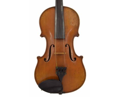
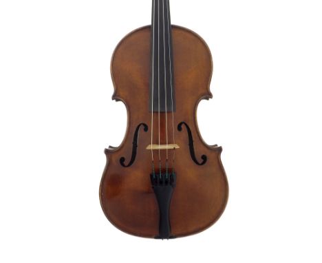
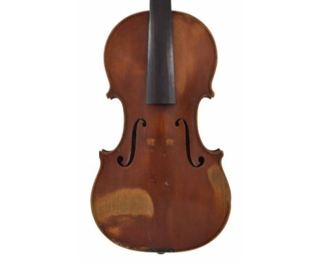
Lot 1444
Good French violin by and labelled Giovanni Battista Rugginelli Luthier ? Paris, Made and Circulated by Beare & Son of London, the two piece back of medium/fine curl with similar wood to the sides, the head of medium curl, the table of a fine width grain widening to the flanks and the varnish of a light reddish-brown colour on a golden ground, 14 1/16", 35.70cm, case
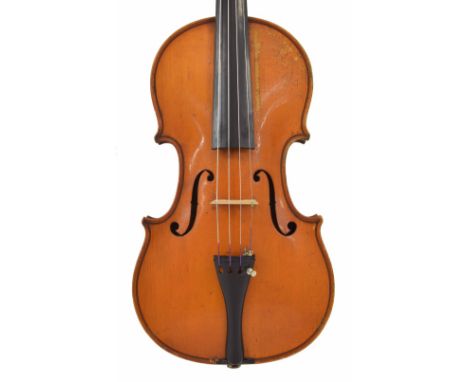
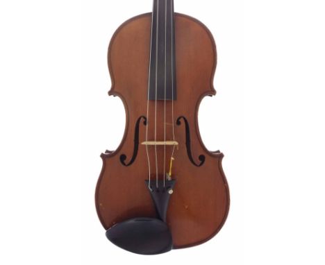
Lot 1445
French violin labelled Roussel Bernardelle ? Paris annee 1837, the one piece back of faint medium curl with similar wood to the sides and head, the table of a medium width grain and the varnish of a light reddish-brown colour on a golden ground, 14 3/16", 36cm, bow *This violin is sold with an appraisal from Edward Withers of London dated 1922
Lot 1448
French violin by and labelled Concerto Hercul, Victor Joseph Charotte, fecit Mircurtice Anno 1926, the two piece back of medium curl with similar wood to the sides and head, the table of a broad width grain and the varnish of a light reddish-brown colour on a golden ground, 14 1/16", 35.70cm
Lot 1493
Hawkes & Sons violin circa 1910, labelled Hawkes & Sons Tyrolese Violin, Denman Street, Piccadilly Circus, London.W., the two piece back of medium curl with similar wood to the sides and head, the table of a medium/fine width grain and the varnish of a light reddish-brown colour on a golden ground, 14 3/16", 36cm
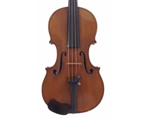
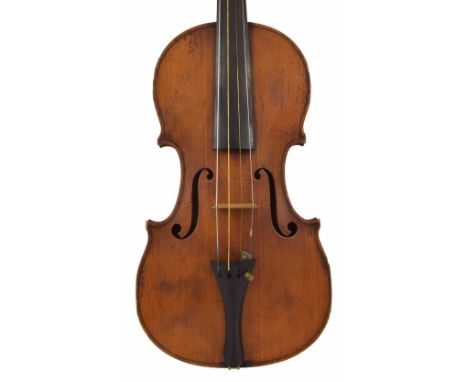
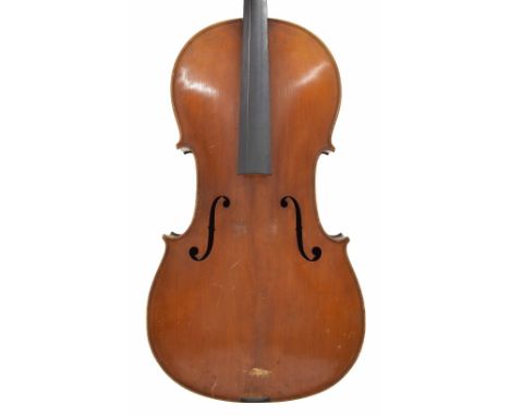
Lot 1504
Good violin by Hart & Son and labelled Hart & Son Makers, 28 Wardour Street W.London..., the two piece back of medium fine curl with similar wood to the sides and head, the table of a medium width grain widening to the flanks and the varnish or a light reddish-brown colour on a golden ground, 14 1/16", 35.70cm, case *This violin was made shortly after the Voller Brothers finished working for Hart & Son, however the scroll in particular shows the hand of The Vollers
Lot 1505
Very interesting violin labelled Ferdinandos Gagliano...1753, also bearing the W.E. Hill & Sons registration number 2184 on the end of the fingerboard, the one piece back of plainish wood with similar wood to the head, the sides of faint broad curl, the table of a medium width grain and the varnish of a light reddish-brown colour on a golden ground, 14", 35.60cm
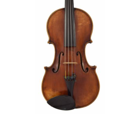
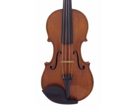
Lot 1515
Good English violin by and labelled Made by Arthur Richardson, Crediton, Devon.1935, no. 227, the two piece back of faint medium curl with similar wood to the sides and head, the table of a fine width grain and the varnish of a light reddish-brown colour on a golden ground, 14 1/16", 35.80cm
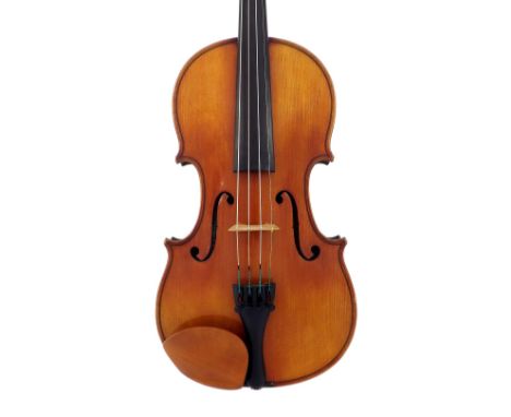
Lot 1521
French violin labelled Francois Barzoni, ? Bateau Bierry, 1886, the two piece back of medium curl with similar wood to the sides and head, the table of a medium width grain narrowing to the flanks and the varnish of a light reddish-brown colour on a golden ground, 14 1/8", 35.90cm, with five nickel mounted violin bows, case

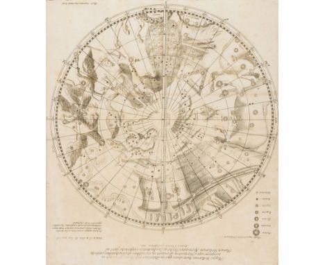
Lot 100
Celestial chart.- Westerhout (Arnold van) Mappa Stellarum Australium quae in Altitudine Poli Borei Graduum..., celestial chart showing the stars and constellations in the southern sky, centred on the south equatorial pole, from 'Observationes Mathematicae, et Physicae in India and China factae à Patre Francisco Noël Societatis Jesu, engraving on laid paper with armorial watermark, sheet 395 x 350 mm. (15 1/2 x 13 3/4 in), old folds, some small repaired tears to extremities, light spotting and surface dirt, unframed, [Prague], 1711
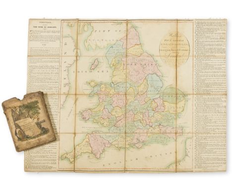
Lot 108
England.- Board Game.- Wallis (J. & E.) Wallis's Tour Through England and Wales, A New Geographical Pastime, engraved map of England as the game board with hand-colouring, letterpress game rules, left and right, 515 x 650 mm. (20 1/4 x 25 1/2 in), dissected and mounted on linen, some light surface dirt and browning, light scuffs and rubbing in places, folding into original slip-case with hand-coloured pictorial title to upper cover, rubbed and worn, 8vo, E. Wallis, 1794.
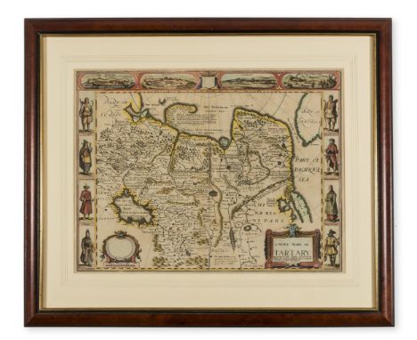
Lot 11
Asia.- Speed (John) A Newe Mape of Tartary, detailed map showing from Lake Baikal through the regions of present-day Manchuria and Siberia to the north of the Great Wall of China, with Korea as an Island, featuring 8 side panels with the people of Tartary in their native costume, and four vignette views above of Nova Zembla, and the silk route cities of Astrakan, Samarkand and Cambalu, engraving with early hand-colouring, 405 x 520 mm. (16 x 20 1/2 in), under glass, central vertical fold, two light creases, minor spotting and browning, framed and glazed, Bassett and Chiswell, 1676.
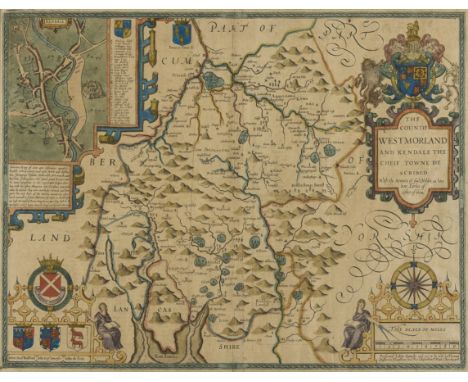
Lot 112
NO RESERVE Cumbria.- Speed (John) The Countie Westmorland and Kendale the Cheif Towne Described, county map with decorative strap-work cartouches, an inset map of Kendale, engraving on laid paper with early hand-colouring, platemark 390 x 515 mm. (15 1/4 x 20 1/4 in), sheet 400 x 525 mm. (15 3/4 x 20 3/4 in), under glass, central vertical fold, handling creases, some surface dirt and light browning, Bassett and Chiswell, [circa 1676]; together with Robert Morden's map of Cumberland, engraving with hand-colouring, 375 x 430 mm. (14 3/4 x 17 in), under glass, central vertical fold, handling creases, framed and glazed, sold by Abel and Churchill, [circa 1695 and later] (2).
Lot 113
NO RESERVE Derbyshire.- Tuke (John) A Map of Ninety Miles by Seventy Five in which Chesterfield is the Centre, Comprising the Counties of Derby and Nottingham, Part of the Counties of York, Lincoln, Rutland, Leicester, Stafford, Salop, Chester and Lancaster, engraved map with hand-colouring, mounted on linen with wooden rollers, sheet 670 x 770 mm. (26 1/2 x 30 1/4 in), some surface dirt and light browning, unframed, rolled, Darton & Harvey, 1798; together with Frederic Sanderson's Poor Law Union and Parish Map of the County of Nottingham Exhibiting in a Comprehensive Manner the Railway System of the District, engraved map with hand-colouring, 740 x 540 mm. (29 1/4 x 21 1/4 in), mounted on linen with early wooden rollers, varnish with some discolouration, other minor surface dirt, unframed, rolled, 1861; and with a rolled map by John Cary of Derbyshire, engraving with some hand-colouring, sheet 670 x 570 mm. (27 1/2 x 22 1/2 in), some off-setting and surface dirt, nicks and tears to margins, 1818 (3).
Lot 115
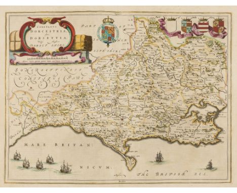
Dorset.- Blaeu (Joan) Comitatus Dorcestria, sive Dorsettia; vulgo Anglice Dorset Shire, county map with harvest-themed title cartouche in the upper left, and seven ships off the southern coast, engraving with hand-colouring, on laid paper with indistinct armorial watermark, platemark 380 x 505 mm. (15 x 19 7/8 in), sheet 460 x 585 mm. (18 1/8 x 23 in), Dutch text verso, central vertical fold, minor handling creases, light surface dirt and browning, unframed, [circa 1650] § Saxton (Christopher) and William Kip (engraver). Dorcestriae Comitatis Vulgo Dorsett, engraved map with some hand-colouring, 275 x 390 mm. (10 3/4 x 15 3/8 in), sheet 335 x 440 mm. (13 1/4 x 17 1/4 in), Latin text verso, central vertical fold, handling creases, some surface dirt, unframed, [circa 1607 and later]; together with a hand-coloured map of Dorset by Robert Modern, and three others by Moll, Cary, and another, engravings, 365 x 420 mm. (14 3/8 x 16 1/2 in), and smaller, occasional minor surface dirt and browning, all unframed, mainly early 19th century (6).
Lot 116
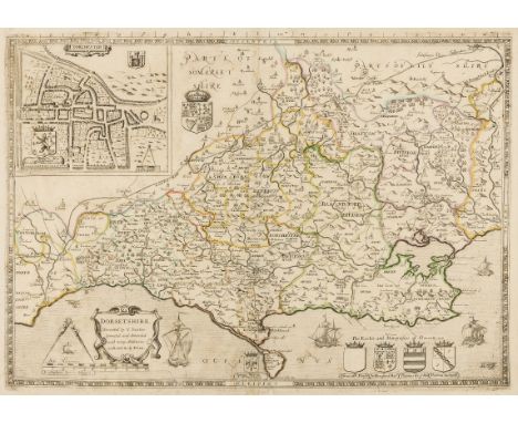
Dorset.- Saxton (Christopher) Dorsetshire Described by C. Saxton. Corrected and Amended with Many Additions as Roads &c. by P. Lea, county map with inset plan of Dorchester in the upper left corner, engraving on laid paper, with outline hand-colouring, platemark 385 x 540 mm. (15 1/4 x 21 1/4 in), sheet 400 x 565 mm. (15 3/4 x 22 1/4 in), central vertical fold with some repaired splitting, other small repairs, minor surface dirt and light browning, unframed, [circa 1689 and later].
Lot 118
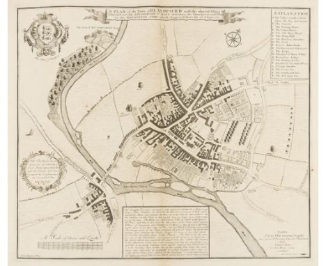
Dorset.- Bastard (William) A Plan of the Town of Blandford ... describing the Damages in each Place by the Dreadful Fire which happened there the 4th of June 1731, engraving on laid paper without watermark, platemark 425 x 495 mm. (16 3/4 x 19 1/2 in), sheet 465 x 565 mm. (18 1/4 x 22 1/4 in), central vertical folds, with corresponding folds, minor handling creases, unframed, Phil. Overton and Samuel Birt, 1731 § Collins (Greenvile) A Draught of Portland the Shambles, and the Race of Portland, sea chart of Portland showing Weymouth in the upper right, from Collins' 'Coasting Pilot', engraving on thick laid paper, sheet 430 x 610 mm. (17 x 24 in), central vertical folds, surface dirt and light browning, minor spotting, unframed, [1744 and later]; together with four town and site plans of Sherborne, the town and Castle of Corfe, Eggerdon Hill, and Poole, engravings, various sizes, 450 x 570 mm. (17 3/4 x 22 1/2 in) and smaller, handling creases, minor nicks and surface dirt, all unframed, [18th and early 19th century] (6).
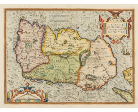
Lot 122
Ireland.- Ortelius (Abraham) Eryn - Hiberniae, Britannicae Insulae, Nova Descriptio - Irlandt, map of Ireland, with north oriented to the right, strap-work title and scale cartouches, with a ship off the northern coastline, engraving on laid paper with armorial watermark, fine early hand-colouring, platemark 355 x 485 mm. (14 x 19 in), sheet 445 x 565 mm. (17 1/2 x 22 1/4 in), Latin text verso, central vertical fold, two small parallel splits in the upper right margin, minor handling creases and light surface dirt, unframed [Antwerp, 1584].Literature:VdB 22 .2⁂ Based on Mercator's 1564 wall map of the British Isles, it is the first map of Ireland to include any geographic details.
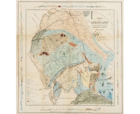
Lot 126
Lake District.- Ruthven (John) Map of the English Lakes and Adjoining Country Geologically Coloured, geological map showing from Lancaster north to Carlisle, and from Whitehaven to Brough, with four diagrams of cross-sections of land around the border, engraving, with extensive hand-colouring, 550 x 510 mm. (21 3/4 x 20 1/8 in), horizontal and vertical folds with some minor repairs to splitting, laid onto thin linen support, light surface dirt, unframed, John Garnett, Windermere, 1855.
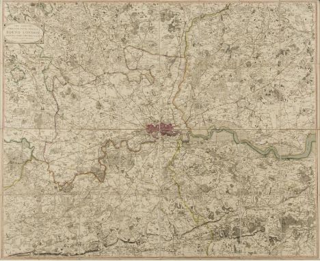
Lot 131
London.- Faden (William) The Country Twenty-Five Miles Round London..., 4th edition, from Windsor to Basildon, and Ware to Reigate, title cartouche upper left, engraved map with original outline hand-colouring, 1050 x 1290mm. (41 3/8 x 50 3/4 in), dissected and mounted on linen, light surface dirt and browning, some spots, lacking slipcase, [Howgego 188 (8)], 1820.
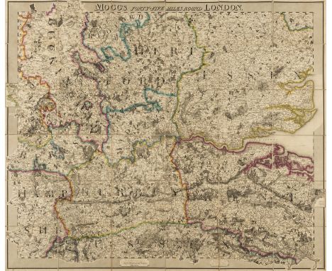
Lot 132
NO RESERVE London.- Mogg (Edward) Mogg's Forty-Five Miles Round London, showing the home counties from Saffron Walden to Rye, and Basingstoke to Faversham, engraved map early outline hand-colouring, 970 x 1180mm. (38 1/4 x 46 1/2 in), dissected and mounted on linen, minor spotting and browning, light surface dirt, folding with brown endpapers into contemporary green marbled slipcase, with printer's label, worn, 4to, [Howgego 287 (1)], 1821.
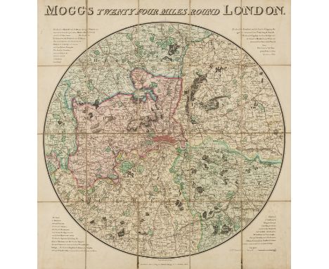
Lot 134
London.- Mogg (Edward) Mogg's Twenty Four Miles Round London, circular map from Crowhurst to Stapleford in the north, and from Windsor to East Tilbury in the east, engraved map with early hand-colouring, 615 x 580 mm. (24 1/4 x 22 3/4 in), dissected and mounted on linen, one small split to fold, minor offsetting, very light browning and surface dirt, folding into later slipcase, rubbed, [c.f. Howgego 235, unrecorded state between (7) and (8)], 1824.
![Scotland.- Collins (Capt. Greenville) [The Moray Firth], sea chart with decorative cartouche in the upper right corner, engra](https://cdn.globalauctionplatform.com/9354bd56-d7cb-4d5b-9f5d-a8f000e9b3ff/cb6d412b-267d-4dc2-cd59-feb6a7f672a5/468x382.jpg)
Lot 148
Scotland.- Collins (Capt. Greenville) [The Moray Firth], sea chart with decorative cartouche in the upper right corner, engraving with some hand-colouring, sheet 495 x 590 mm. (19 1/2 x 23 1/4 in), laid onto old paper support, central vertical fold, minor worm-hole damage with repair in the upper centre, and upper margin, minor handling creases, light surface dirt, unframed, [circa 1693 and later].
Lot 149
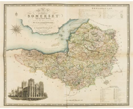
NO RESERVE Somerset.- Greenwood (Christopher) Map of the County of Somersetshire, from Actual Survey Made in the Years 1820 & 1821, county map with vignette of Wells Cathedral in the lower left, decorative calligraphic title in the upper left corner, engraving with early hand-colouring, platemark 630 x 730 mm. (24 3/4 x 28 3/4 in), sheet 650 x 800 mm. (25 1/2 x 31 1/2 in), central and vertical folds with some splitting, handling creases, light surface dirt, 1829; together with Greenwood's 'Map of the West Riding of the County of York', engraving with hand-colouring, sheet 605 x 850 mm. (23 3/4 x 33 1/2 in), some off-setting and browning, folds with minor splitting, unframed, 1834 (2).
Lot 153
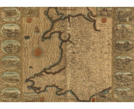
Wales.- Speed (John) Wales, decorative map with the four corners showing the diocesan cities of Bangor, St. Asaph, Llandaff and St. David's, while the compass rose bears the arms of the Prince of Wales, the two side panels show the twelve county towns of Wales, excluding Monmouth, engraved map with early hand-colouring, platemark 380 x 510 mm. (15 x 20 1/8 in), under glass, central vertical fold, light even-browning, minor nicks to extremities, and surface dirt, framed and glazed, Basset & Chiswell, [1676]
Lot 18
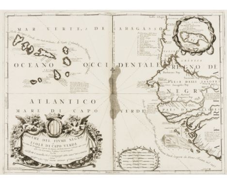
Cape Verde.- Coronelli (Vincenzo Maria) Bocche del Fiume Negro et Isole di Capo Verde, showing Cape Verde Islands and of part of the coast of Senegal to the right, engraved map, an excellent impression on laid paper with swallowtail flag watermark, platemark 460 x 615 mm. (18 1/8 x 24 1/4 in), central vertical fold, light offsetting and surface dirt, unframed, Venice, Padovani, [circa 1696].

Lot 2
NO RESERVE America.- Foster (J.W.) & Whitney (J.D.) Geological Map of the Lake Superior Land District in the State of Michigan, showing the geology of the Upper Michigan Peninsula, Isle Royale and the north shore of Lake Superior and indicates copper, iron, silver, marble furnaces, iron forages and active/inactive mines, lithograph with hand-colouring, three sections joined, total approx. 620 x 950 mm. (24 1/2 x 37 1/2 in), mounted on linen, with handling creases, minor surface dirt and light browning, unframed, J. Ackerman, 1847.
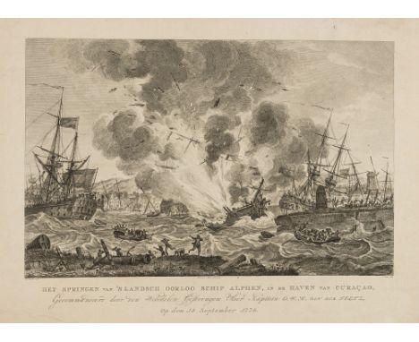
Lot 24
Caribbean.- Curaçao.- Kobell (Hendrik, 1751-1799), after. Het springen van 's landsch oorlog schip Alphen, in de haven van Curaçao, engraving by J. Punt, on laid paper with watermark of fleur-de-lis, platemark 330 x 420 mm. (13 x 16 1/2 in), sheet 345 x 440 mm. (13 1/2 x 17 1/4 in), handling creases, minor nicks to edges, light surface dirt, unframed, Johannes Allart, 1779.⁂ In 1778 a Dutch Marine frigate, named De Alphen, exploded in the Curaçao harbour, the St. Anna Bay. Many of the artefacts which survived from the blast are now housed in The Curaçao Maritime Museum.
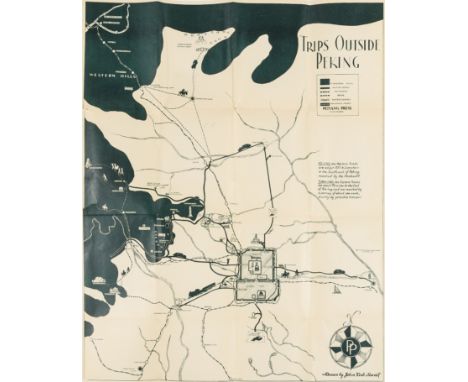
Lot 29
China.- Sewall (John Kirk) Map of the Western Hills, including a detailed description of the spots of interest and of the roads leading to same, title and 9 pp. of descriptive text, with map 'Trips Outside Peking' showing Beijing with old city wall, the inner city wall and the Imperial City, and other locations of interest in the surrounding area, lithograph printed in dark-green, 580 x 470 mm. (22 3/4 x 18 1/2 in), two tears into map, folding into original paper wrappers, printed title to upper cover, some surface dirt and finger-soiling, with original slip-case, rubbed and slightly worn, 8vo, Peiyang Press, Ltd. 1935 § Wyld (James) Map of China Compiled from Original Surveys & Sketches, showing China and Korea, with The Great Wall and the Imperial Canal both depicted, engraving with some hand-colouring, 650 x 830 mm. (25 5/8 x 32 3/4 in), dissected and mounted on linen, some minor off-setting and light browning, folding with blue marbled ends, surface dirt, without slip-case, 1841 (2).
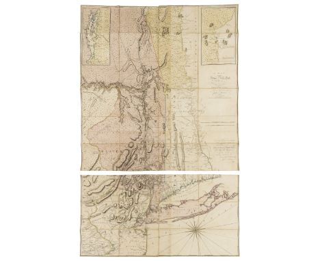
Lot 3
America.- New York.- Montresor (John) A Map of the Province of New York, with Part of Pensilvania, and New England, wall map of New York to the east and west of the Hudson River Valley, including all of Long Island and parts of Connecticut and New Jersey, engraving with hand-colouring, total approx. 1455 x 935 mm. (57 1/4 x 36 3/4 in), dissected and mounted on linen, but split along horizontal fold, three sections up from the bottom, otherwise some light off-setting, minor browning and surface dirt, folding into later cloth drop-back box, 4to, A. Dury, 1775.
![NO RESERVE France.- Anonymous (18th century) Environs de Barcelonette et de Beuil [on sheet with] Environs de Coni, Tende, et](https://cdn.globalauctionplatform.com/9354bd56-d7cb-4d5b-9f5d-a8f000e9b3ff/0df73cdd-911b-42b2-96b1-608f9592feb1/468x382.jpg)
Lot 36
NO RESERVE France.- Anonymous (18th century) Environs de Barcelonette et de Beuil [on sheet with] Environs de Coni, Tende, et Albenga [and] Environs de Castellane et Antibes [and] Environs de Monaco, Vintimille, et Oneille, four maps printed on one sheet, engravings, on laid paper, with outline hand-colouring, numbered '5' in pen and ink upper right, and '5/13/ Suite' on the reverse, total sheet 524 x 667 mm. (20 5/8 x 26 1/4 in), central vertical fold, small split to lower margin, light handling creases, minor spotting and surface dirt, unframed, [early 18th century].
Lot 37
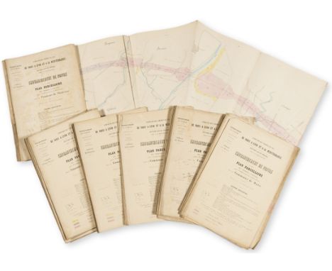
NO RESERVE France.- Ardèche.- Paris to Lyon and the Mediterranean Railway Co. A group of eight large folding plans of the southern section of the rail network, covering areas from Lyon to the Mediterranean, with a small group of accompanying documents, lithograph plans printed in colour, folding pamphlets with paper wrappers, all with printed title to upper cover, some spotting and light surface dirt, 4to, [circa 1840s and later] (Qty.).
Lot 41
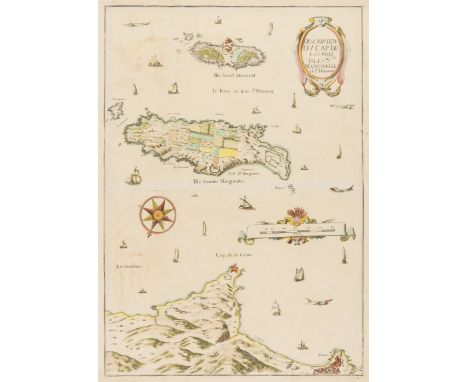
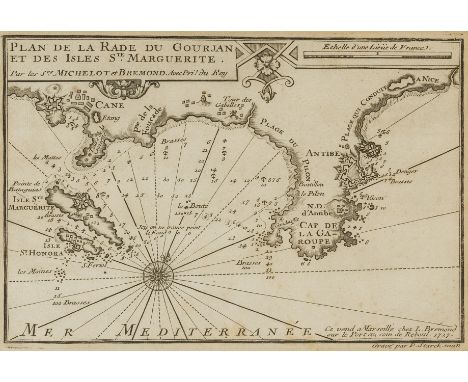
NO RESERVE France.- Côte d'Azur.- Tassin (Charles, publisher) Description Du Cap De La Croix Isles Ste Marguerite et St Honorat, map showing Cannes and the Cap de la Croisette, with the islands of St Marguerite and St Honorat, including many ships, sea monsters, and with title cartouche upper right, engraving with hand-colouring, sheet 520 x 370 mm. (20 1/2 x 14 1/2 in), trimmed to borderline and re-margined, handling creases and light folds, minor nicks, surface dirt, unframed, [circa 1640].Literature:Pastoureau, M. Tassin II-33
Lot 43
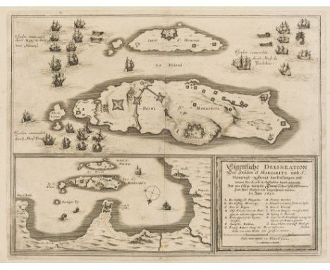
NO RESERVE France.- Côte d'Azur.- Merian (Matthaeus) Eigentliche Delineation der insulen S. Margarite und St. Honorat, engraving, on laid paper with watermark of the letter M, sheet 318 x 380 mm. (12 1/2 in), central vertical fold, minor surface dirt and light browning, unframed, [circa 1650].⁂ Merian's map illustrates the French campaign against the Spanish that resulted in the return of the islands to French control in 1637.
Lot 46
NO RESERVE France.- Côte d'Azur.- A group of eight framed maps of the region from Cannes to Antibes, several showing ports and fortifications, with maps by Georg Christophe Kilian, Charles Inselin, John Luffman, and others, engravings, three with hand-colouring, various sizes, largest 200 x 270 mm. (8 x 10 3/4 in) and smaller, all under glass, minor handling creases and light surface dirt, [mainly 18th century] (8).
Lot 47
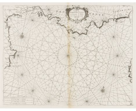
NO RESERVE France.- Mediterranean.- Coronelli (Vincenzo Maria, publisher) La Costa di Linguadocha, Provenza, et una Parte d'Italia, showing the coastline from the region of Languedoc-Roussillon, with part of Spain, across the Provence-Alpes-Côte d'Azur to Albenga in Italy, with part of Corsica in the lower right, engraving, by Francesco Maria Levanto, on laid paper without watermark, platemark 400 x 515 mm. (15 3/4 x 20 1/4 in), sheet 500 x 660 mm. (19 3/4 x 26 in), central vertical fold with small split to centre and light browning, minor nicks to extremities, light handling creases and surface dirt, unframed, [circa 1696].
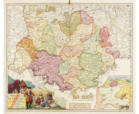
Lot 52
France.- Provence.- Homann (Johann Baptiste) Provincia Indigenis dicta la Provence, map of the Provence from Arles to Monaco, with inset plan of Toulon harbour in the lower right corner, and pictorial cartouche in the lower left, engraving with full hand-colouring, on laid paper with indistinct watermark device, platemark 495 x 585 mm. (19 1/2 x 23 in), numbered '45' in brown ink on verso, central vertical fold with small rust-stain at upper section, some light spotting and surface dirt, unframed, Nuremberg, [circa 1730].
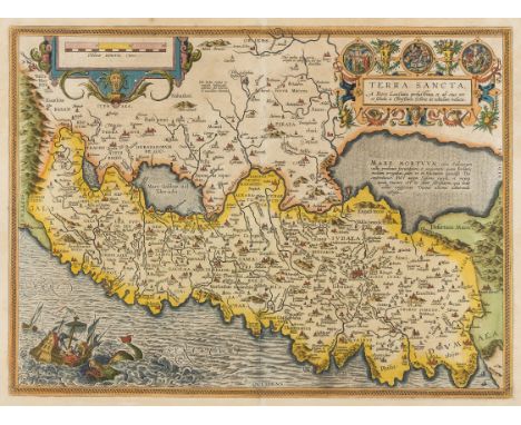
Lot 54
Holy Land.- Ortelius (Abraham) Terra Sancta, map of the Holy Land oriented to the east, showing from Beirut to Gaza, with strap-work title cartouche with three vignette roundels depicting Christ's crucifixion and resurrection, and with large sea monster and vessel in the lower left corner, engraved map with early hand-colouring, on laid paper with armorial watermark, platemark 370 x 500 mm. (14 1/2 x 19 3/4 in), sheet 445 x 540 mm. (17 1/2 x 21 1/4 in), Latin text verso, central vertical fold, small nicks and tears to extremities of margins, minor surface dirt and light browning, unframed, [Antwerp, 1603].Literature:VdB 173.1
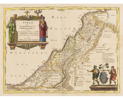
Lot 57
Holy Land.- Jansson (Jan) Judaeae seu Terrae Israelis, map showing the divided kingdoms of Judea and Israel, with large title cartouche supported by the figures of Moses and Aaron in the upper left corner, and two figures in rustic costume carrying oversized grapes in the lower right corner, engraving with hand-colouring, on laid paper without watermark, platemark 360 x 485 mm. (14 1/4 x 19 1/8 in), sheet 490 x 610 mm. (19 1/4 x 24 in), central vertical fold with parallel light crease, some spotting and browning, mainly visible in the margins, unframed, [Amsterdam, circa 1650].
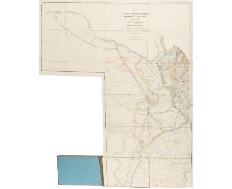
Lot 59
India.- Joseph (Charles) Map of the Grand Trunk Road from the Karamnassa to the Sutledge, Part Second, from Agra to Ferozepoor, large folding road map of one of the oldest and longest trade routes linking the Indian subcontinent with Central Asia, lithographed map with hand-colouring, 2270 x 1075 mm. (89 1/2 x 42 1/4 in), dissected and mounted on linen, some surface dirt and light abrasion, folding with blue endpapers into original cloth covered boards with publisher's label on upper cover, worn, oblong 4to, 1854⁂ Scarce. The present map is the second part published to accompany an earlier publication, in 1851, of the area between Agra and Benares. Little is known about Charles Joseph, but he appears to be listed as a surveyor in the Surveyor General's office.
Lot 60
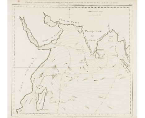
Indian ocean.- Sayer (Robert) Carte du Sisteme des Courants des Mers de l'Inde ... N.E au N.; Carte du Sisteme des Courants des Mers de l'Inde ... S.O au N., two charts detailing monsoons in the Indian Ocean, engraving, each platemark approx. 460 x 520 mm. (18 1/8 x 20 1/2 in), sheets 475 x 640 mm. (18 3/4 x 25 1/4 in), some worm-hole damage to margins, minor surface dirt and light browning, 1776; together with a another impression of Sayer's '95 (a)' chart of monsoons, and Carte Reduite de l'Archipel du Nord-Est de l'Isle Madagascar, depuis la Ligne Equinoctiale jusqu'au 21d. 30m. de Latitude Meridional after Mannevillette, and Captain W.F.W Owen's Chart of the East Coast of Madagascar, engravings, 810 x 650 mm. (31 7/8 x 25 5/8 in), and smaller, occasional surface dirt and handling creases, all unframed, [18th and 19th century] (5).
Lot 61
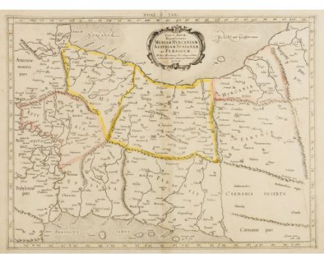
Iran & Iraq.- Mercator (Gerard) Tab. V. Asiae, repraesentans Mediam Hyrcaniam, Assyriam, Susianam, ac Persidem, Ptolemaic map showing much of Persia (Iran), Mesopotamia (Iraq) and part of Armenia, from the Persian Gulf to the Caspian Sea, with Babylon (Baghdad), the Tigris and Euphrates Rivers, engraving with some outline hand-colouring, platemark 350 x 465 mm. (13 3/4 x 18 1/4 in), sheet 400 x 510 mm. (15 3/4 x 20 1/8 in), central vertical fold with small repairs to splitting, light handling creases and surface dirt, minor spotting in the upper left section, unframed, [Amsterdam, 1578 but circa 1695].

Lot 62
Italy.- Rossi (Giacomo Giovanni) Patrimonto di S. Pietro, olim Tuscia Suburbicaria, regional map of Tuscany, with large decorative title cartouche upper left, etching and engraving on four sheets, unjoined, excellent clean impressions, each on laid paper with watermark of an encircled fleur-de-lis, each platemark approx. 440 x 570 mm. (17 3/8 x 22 1/2 in), sheets approx. 470 x 675 mm. (18 1/2 x 26 1/2 in), minor drying creases visible, light spotting and surface dirt, unframed, rolled, 1696; together with the four sheet map Il Lazio ..., etching and engravings, each on laid paper with watermark of an encircled fleur-de-lis, each platemark approx. 435 x 570 mm. (17 1/4 x 22 1/2 in), all with full margins, light spotting and surface dirt, unframed, rolled, 1693, (2 maps, 8 sheets).⁂ Excellent impressions of Rossi's scarce regional maps of Italy.
Lot 66
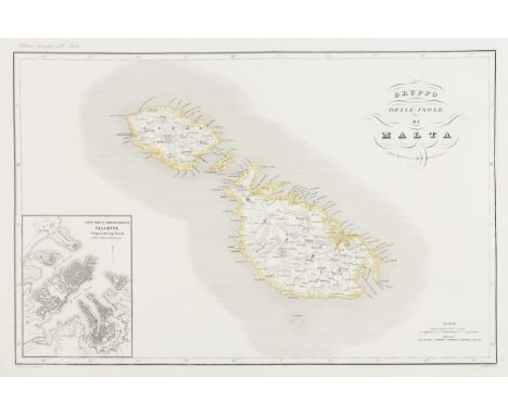
Malta.- Pozzi (G.) Gruppo delle Isole di Malta, map of the Maltese archipelago, with inset plan of Valletta in the lower left corner, engraving with outline hand-colouring, on wove paper without watermark, sheet 410 x 580 mm. (16 1/8 x 22 3/4 in), minor surface dirt and light handling creases, unframed, Milan, [circa 1850].
Lot 70
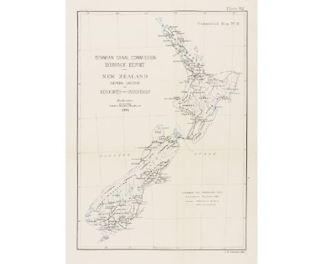
New Zealand.- Harden (O.B.) Isthmian Canal Commission Economic Report- New Zealand Showing Location of Resources and Industries, map of New Zealand showing the North and South Islands, including railroads and projected railroads, from the Report of the Isthmian Canal Commission 1899-1901, photo-lithograph, on thin wove paper, sheet 485 x 350 mm. (19 x 13 3/4 in), folds with minor repairs to splitting, light surface dirt, unframed, 1901.
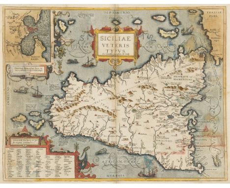
Lot 78
Sicily.- Ortelius (Abraham) Siciliae Veteris Typus, map of ancient Sicily, with an inset plan of Syracuse, with three decorative cartouches, ships and sea monsters, engraving, on laid paper with crossed arrows watermark, with early hand-colouring, platemark 370 x 485 mm. (14 1/2 x 19 1/8 in), sheet 405 x 530 mm. (16 x 20 7/8 in), central vertical fold, minor damp-stains and surface dirt, light handling creases, unframed, [Antwerp, 1584].Literature:VdB 211.2
Lot 79
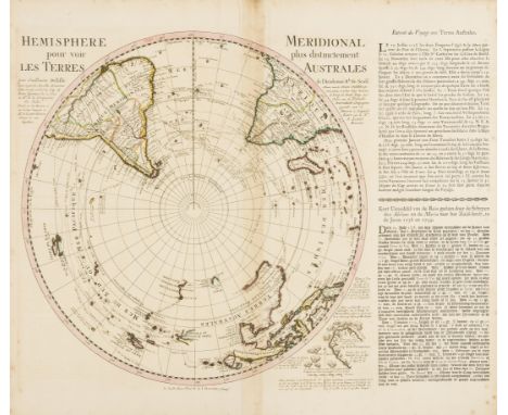
Southern Hemisphere.- Ottens (Reiner & Joshua) Hemisphere Meridional pour voir plus distinctement Les Terres Australes, featuring De L'Isle's map of the Southern Hemisphere with the tracks of the explorers and circumnavigators around the southern oceans, including Magellan in 1520, Abel Tasman in 1642, and Edmund Halley in 1698-1700, engraved map with descriptive text in French and German, on laid paper with watermark initials of 'PL' in ligature, map 465 x 610 mm. (18 1/4 x 24 in), sheet 540 x 640 mm. (21 1/4 x 25 1/4 in), central vertical fold with minor creasing and discolouration, light spotting and surface dirt, unframed, Amsterdam, [circa 1740].

Lot 80
South America.- Falklands.- Bellin (Jacques Nicolas) Carte Reduite des Isles Malouines ou Isles Nouvelles que les Anglois Nomment Aujourhui Isles de Falkland ... sur les Observations Memoirs et Journaux des Francois et des Anglois, detailed chart of the Falkland Islands with depth soundings and the tracks of recent French and English ships, with coastal profile views at the top, engraving with hand-colouring, on thick laid paper with double-headed eagle watermark and text-based countermark, platemark 595 x 900 mm. (23 1/2 x 35 1/2 in), sheet 635 x 935 mm. (25 x 36 3/4 in), central and vertical folds, minor nicks and tears, some repaired, light spotting and browning, numbered 88 in brown ink in the upper right corner, unframed, 1771 § Chatelain (Henry Abraham) Carte de la Terre Ferme, du Perou, du Bresil, et du Pays des Amazones ..., engraved map with hand-colouring, 415 x 530 mm. (16 1/4 x 20 7/8 in), central vertical fold with minor splitting at ends, light surface dirt, unframed, [circa 1720] (2)
-
534297 item(s)/page