Blat CLXIII The recto of this sheet with German text shows a council of Popes held by Roman Pope Gregory the Third and a portrait of Charles Martel, ruler of Francia. The verso of the sheet depicts portraits of Popes Zachary, Stephen the Second, and Paul the First. Light toning with a faint damp stain along top edge of sheet. 16.1 W x 10.9 H Schedel, Hartmann 1493
We found 534325 price guide item(s) matching your search
There are 534325 lots that match your search criteria. Subscribe now to get instant access to the full price guide service.
Click here to subscribe- List
- Grid
-
534325 item(s)/page
Blat CXLVI The recto of this sheet with German text gives a depiction of a night in Italy in 570 in which blood rained from the clouds and large rocks were tossed about. After then raining for several days, animals in human form began to appear in the rivers. Also on the recto are portraits of Saint Leonard, Maurus, Saint Columbanus, Bishop Herculanus, and Simeon of Antioch. On the verso are the Roman Popes Pelagius, Johannes III, Benedictus, and Pelagius II. Watermarked paper with light soiling, a few spots of foxing, and a faint damp stain along top edge of sheet. Title and page number cut off at top on recto, as issued. 16.1 W x 10.9 H Schedel, Hartmann 1493
Blat CLXIIII The recto of this sheet with German text shows the portraits of Emperors Constantine the Fifth, his son Leo the Fourth, and Leo`s son Constantine the Sixth. The verso depicts portraits of Saint Gangolf, the children Amelius and Amicus, Saint Burchard, Carloman, and Bishop Albinus. Light soiling with several minor damps stains. 16.1 W x 10.9 H Schedel, Hartmann 1493
Blat CLXVI The recto of this sheet with German text shows Emperors Nicephorus, Stauracius, and Michael, along with a depiction of the Seventh Council of Bishops held by Pope Adrian. The verso includes the portraits of King Desiderius, Paul the Deacon, Usuard (a monk), and Alcuin. Light soiling with a damp stain along top edge of sheet. 16.1 W x 10.9 H Schedel, Hartmann 1493
Blat CL The recto of this sheet with German text shows portraits of Authari Flavius and Theodolinda, King and Queen of the Lombards, and Authari`s successor, Agilulf. The verso depicts the portraits of Sisebutus, King of the Visigoths, and Popes Deusdedit, Boniface the Fifth, Honorius, Severinus the First, and John the Fourth. Watermarked paper with light soiling, a few ink marks on recto, and a faint damp stain along top edge of sheet. 16.1 W x 10.9 H Schedel, Hartmann 1493
[Book of Hours Leaf] Superb vellum leaf from this important transitional period when books began to be printed from movable type, decorated with metal-cut illustrations and combined with hand-painted illuminated initials. It is printed on vellum in black and red with many initials hand painted in red, blue and gold. On the verso is a depiction of the Annunciation to the shepherds, with Bethlehem visible in the background. One shepherd is playing the flute while his dog appears to dance! The angel above the scene holds a banner with the well known words: ""Gloria in altissimis deo et in terra pax"" (Glory in the highest to God and on Earth peace). The recto has an ornamental border depicting scenes from the Old and New Testament with captions in red, as well as a mythical animal at top. Thielman Kerver was a printer in Paris, who worked ""in vico sancti Iacobi ad signum Vnicornis & ibidem venales habent"" (in Saint Jacob`s lane under the sign of the Unicorn where they are also for sale). He began printing Books of Hours in 1497 and continued until his death in 1522. His widow, Iolande Bonhomme, took over the firm, and continued to produce liturgical books until 1556. Kerver`s work is much less common than that of his colleagues, Simon Vostre and the Hardouins. Light soiling and toning. 5.4 W x 3.6 H Kerver, Thielman 1505
[Books of Hours Leaf] Superb vellum leaf from this important transitional period when books began to be printed from movable type, decorated with metal-cut illustrations and combined with hand-painted illuminated initials. It is printed on vellum in black and red with many initials hand painted in red, blue and gold. The text on both recto and verso has an ornamental border depicting scenes from the Old and New Testament with captions in red, as well as some mythical animals. The vignettes on the recto tell the story of Judas, who received 30 pieces of silver in exchange for the betrayal of Jesus. Beginning with the 5th line from the top on the recto is Psalm 121: ""Laetatus sum in his quae dicta sunt mihi in domum Domini ibimus"" (I rejoiced at the things that were said to me: We shall go into the house of the Lord.)Thielman Kerver was a printer in Paris, who worked ""in vico sancti Iacobi ad signum Vnicornis & ibidem venales habent"" (in Saint Jacob`s lane under the sign of the Unicorn where they are also for sale). He began printing Books of Hours in 1497 and continued until his death in 1522. His widow, Iolande Bonhomme, took over the firm, and continued to produce liturgical books until 1556. Kerver`s work is much less common than that of his colleagues, Simon Vostre and the Hardouins. Light soiling and toning. 5.4 W x 3.6 H Kerver, Thielman 1505
[Vellum Manuscript Indenture] This indenture serves as testament to a one year lease of a messauage or burgage - a dwelling on a small plot of land. The lessors are William Blakisten and Francis Corner of Sunderland in the County of Durham, and the lessee is John Fotherinham, who must pay 5 Shillings in return for the lease. Signed on August 30, 1774.The top of the indenture is cut in a jagged (""toothed"") line, as was the common practice with indentures. The legal contract was duplicated on a single sheet, and then the copies were separated by a jagged edge, so that the two pieces could be fit together again to verify authenticity. The indenture includes tax stamps and two red wax seals. Light soiling 13.8 W x 18.6 H 1774
[Vellum Manuscript Indenture] This indenture serves as testament to a one year lease of a messauage - a dwelling on a small plot of land. The lessors are Michael Laws (a ""Gentleman"") of Sunderland near the Sea and Thomas Laws (a farmer) of Easington, both in the County of Durham, and the lessee is Robert Ayre (a Keelman), also of Sunderland. The lease requires Ayre to pay 5 Shillings in return for the dwelling on Lombard Street (also known as Pewterers Lane) that measures 15.5 feet from north to south and 23 feet from east to west, as well as an additional 7 feet of land in front of the dwelling. Signed on February 8, 1811.The top of the indenture is cut in a jagged (""toothed"") line, as was the common practice with indentures. The legal contract was duplicated on a single sheet, and then the copies were separated by a jagged edge, so that the two pieces could be fit together again to verify authenticity. The indenture includes tax stamps and two red wax seals. There is light soiling and some foxing. 16 W x 26.2 H 1811
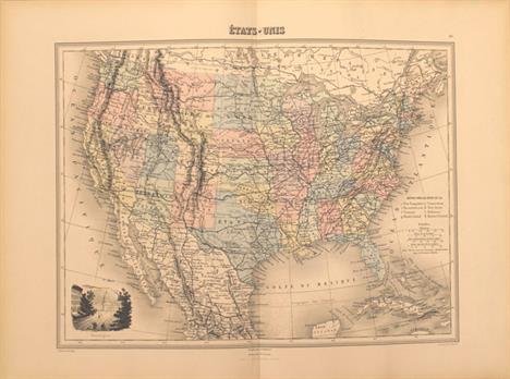
A Prospect of the Most Famous Parts of the World [bound with] England Wales Scotland and Ireland DescribedÂ… This handsome miniature atlas is famously known as the ""miniature Speed"" atlas since the maps, engraved by Pieter van den Keere, were based on John Speed`s folio-sized maps published under the same title, A Prospect of the Most Famous Parts of the World. This example is a dual atlas containing both the world atlas and an atlas of the British Isles. Both atlases had an interesting publication history, beginning with the atlas of the British Isles, which was first published between 1605 and 1610. In 1619, the British Isles maps came into the hands of London printer George Humble, who included additional maps and reprinted them under the name of John Speed, thereby initiating the popular series of ""miniature Speed"" atlases. George Humble had published the first edition of John Speed`s folio-sized Theatre of the Empire of Great Britain in 1612 and A Prospect in 1627, both of which saw great success. The first edition of the miniature Prospect atlas appeared in 1646 published by George Humble`s son, William Humble, and was sometimes bound separately from the British Isles atlas and sometimes bound in a dual atlas. The miniature maps in A Prospect were engraved by Van den Keere while in his 70`s, and are believed the be the last maps engraved by him before his death at the age of 75. The atlas contains 19 of 20 maps: Asia, Africa, Europe, Americas, eleven maps of European countries, Persia, the Turkish Empire, China and Tartary. (The world map is perished.) Each of the maps is single page with text on verso taken from Speed`s folio atlas, and all are signed with Van den Keere`s Latinized name, Petrus Kaerius. The simple, typographic title page contains the list of maps and is dated 1646 with the imprint of William Humble. The western hemisphere map, America, depicts California as an island with a flat northern coast and several place names. The cartography of this map is based on Goos` folio map from 1626, and omits any French presence in Canada. Newe Ing. Land is located north of the St. Lawrence River, and Plymuth is the only European settlement depicted. Interestingly, in this example the printer accidentally printed the map of the Low Countries on the verso of the page of text describing Germany. He corrected the error by printing the map of Germany on a separate sheet, and then pasting it on top of the map of the Low Countries (which also correctly appears later in the atlas).There are 62 (of 63) maps in England Wales Scotland and Ireland, including separate maps of England, Wales, Scotland and Ireland, and 58 county maps. (The folding map of the British Isles is not included.) The majority of the British Isles maps were also engraved by Van den Keere and were based on Saxton for the English and Welsh county maps, on Ortelius for the Scottish maps, and on Van den Keere`s own map of Ireland for the Irish maps. It is believed that the map of England was not engraved by Van den Keere, but was commissioned by Humble for the 1627 edition and was based on Speed`s folio map, omitting the costumed figures. The text in this atlas was derived from Speed`s Theatre of the Empire of Great Britain. The title page is dated 1627 with the imprint of George Humble and features two putti, a Dane and a Norman.This is the first edition of the dual atlas to be published. Oblong octavo. New linen spine with original leather boards.The provenance of this atlas is quite fascinating, as it comes from a direct descendent of the cartographer John Speed. The Speed family believes the atlas was purchased in the 1800`s and then passed down from generation to generation. This is the second of only two atlases consigned by the Speed family. Condition code is for the maps, which are all in very good to near fine condition (with the exception of the world map, which has perished) with very light toning on some. There is a light damp stain in the gutter at top, entering the top corner of a few maps. The folding map of Yorkshire has a very small rust hole and stain. There are chips along the edges of the first and last few pages, including the Prospect title page. The England title page is remargined at bottom and has a few pencil markings. Original covers are moderately worn with a repaired crack on the back cover and the corners are bumped and chipped. 4.3 W x 6.6 H Speed/Kaerius, 1627-46
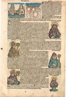
Philippi Cluverii Introductionis in Universam Geographiam Attractive example of the standard geographical textbook of the seventeenth century, by the father of modern historical geography. The atlas is complete with thirty eight maps. The Introductionis was published numerous times between 1624 and 1729 with each successive edition becoming more elaborate and the later editions including finely engraved maps. About half the maps are classical ones derived from Ortleius` Paregon. The world map shows California as an island. This edition was published by Daniel Elzevir. 24mo, engraved title page, 388 pp., 1 folding table, 38 double-page folding maps, table of Roman Emperors and index. Original full calf binding with raised embossed bands on spine. Maps range from very good to near fine with some light damp staining along the lower border of some maps. The maps of Scandinavia and Italy have small chips in the blank margins just touching the neatline. The title page is moderately toned and soiled. Covers are worn, there are small chips to the spine at top and bottom, and the hinges are starting. 5.5 W x 3.3 H Cluver, Philipp 1661
A Complete Genealogical, Historical, Chronological, and Geographical AtlasÂ… This is Lavoisne`s second American edition folio atlas ""carefully revised and corrected"" by C. Gros and J. Aspin. Published by M. Carey and Sons, and printed by T.H. Palmer ""on the Ruthven Press, and on J. & T. Gilpin`s Machine Paper."" The atlas is complete and contains 28 double-page maps, plus scores of detailed and colorful tables, chronological and historical, on 71 plates. The maps are listed below.World in hemispheres; Ancient World; Ancient World of Noah; Canaan & Egypt (two single-page maps); Ancient Greece; Roman Empire; Incursion of the Barbarians; Europe 1820; England, Scotland & Ireland; England & Wales; Scotland; Ireland; France; FranceÂ…Treaty of 1815 with Netherlands, Switzerland and part of Italy; Spain & Portugal; Germany; Kingdom of Netherlands; Italy; Poland; Russia; Denmark (single page); Sweden (single page); Turkey in Europe (single page); Turkey in Asia (single page); Asia; China; Hindoostan or India; Africa; North America (single page); South America with the Conquests of Pizarro (single page); United States; and South America. The United States map, by John Melish, provides a detailed view of the Missouri River and the headwaters of the Columbia River based on information from Lewis and Clark`s expedition. The new state of Missouri is shown with a straight western border. Michigan Territory includes the eastern part of present-day Wisconsin, which is still a part of the North West Territory. The large Arkansas Territory takes in most of present-day Oklahoma. Texas is a part of Mexico. One of the most interesting features of the map is the river system in the West, near the Highest Peak, where the headwaters of several major rivers all originate within a few miles of one another - Red River of California (Colorado), Multnomah (Willamette), Rio del Norte (Rio Grande), Arkansaw (Arkansas), and the Platte.Hardbound in quarter calf and tips over olive boards. Title page, introduction, contents, maps and tables. The bookplate states ""This book belonged to the library of Anson Phelps Stokes, Esq. 1838-1913 of New York City, a merchant, banker, publicist, and multimillionaire, and on his beath became the propoerty of Rev. Anson Phelps Stokes."" Overall maps are in good to near fine condition in original color, with light toning and offsetting. A few of the maps, most notably the Americas, Asia and India, have a small area of color oxidation near the gutter (with the Americas map having a few resultant cracks). The map of South America has a short centerfold separation and edge tears resulting in minute loss of image. Covers are moderately stained and worn and the hinges are starting. A previous ownerÂ’s pastedown is located on the inside front cover with ex-library stamps on the verso of the title page. 17.8 W x 12.3 H Lavoisne/Aspin, 1820
A General Atlas, Containing Maps Illustrating Some Important Periods in Ancient History; and Distinct Maps of the Several Empires, Kingdoms and States, in the World... This complete atlas contains 44 maps (two of which are double-page) and two tables: Comparative Heights of the Principal Mountains and Comparative Lengths of the Principal Rivers. The atlas begins with two chapters on A Memoir of the History of Geography and Outlines of Physical Geography, which include several engravings of mountains around the world interspersed within the text. The maps include four of the ancient world, a double-hemisphere world map and one on Mercator`s projection, maps of the continents, eighteen maps of European countries, six maps of Asian countries, United States, West Indies, three maps of the South Pacific, and one map of the Arctic Circle. Each map (with the exception of the two world maps) features one or more vignettes illustrating a subject related to the map. The maps were drawn by Wyld and engraved by N.R. Hewitt and W.H. Lizars. Published by John Thomson in Edinburgh, to whom the atlas is sometimes credited. The map of the young United States includes several important historical regions. One of the most unique and scarce features on early maps of the United States is the appearance of Franklinia. This ephemeral state appeared on only a small number of maps into the early part of the 19th century, this being a late example. Another interesting feature is the region labeled Indiana that takes up what is now West Virginia. This land was a major contention between the private Indiana Land Company and the State of Virginia in the latter part of the 18th century. Georgia extends from South Carolina to the Mississippi River. Several interesting place names include the Heckerton Settlement, many early forts, Indian villages, and the location of the winter camps for Lewis & Clark in 1803/04 and Lieut. Pike`s two years later. The large Western Territory takes up present-day Michigan, Wisconsin, Illinois, Indiana and Ohio with the large Louisiana Territory further west. The map of the Arctic Regions (Discoveries of Capts. Ross, Parry & Franklin in the Arctic Regions) shows recent discoveries up to 1827. The discoveries and routes of Captains Ross, Parry and Franklin are depicted, and there are notes on MacKenzie`s discoveries and the point reached by the HMS Blossom under Capt. Beechey. Alaska is named Russian Settlements, and the coastline is still quite conjectural. The map features five vignettes of coastal views, including Baffin Bay, Burnet`s Inlet, Coppermine River, and the south side of Scoresby`s Sound. The two maps of Australia, on one sheet, show the extent of interior exploration. The Map of Van Diemens Land shows the new road linking Hobart and Launceston and includes a view of Hobart Town. The map of New South Wales focuses on the region around Sydney, which is divided into 38 districts, and includes a view of Sydney.Folio. Rebound with quarter faux leather and tips over original green cloth boards, with new endpapers. The maps, in original color, are very good to near fine with some occasional light offsetting. The title page and frontispiece have heavy offsetting. Text is very good. Binding is sound with lightly worn covers. 14.5 W x 11 H Wyld, James 1827
[Lot of 2] An Atlas of Ancient Geography [and] Mitchell`s Ancient Atlas. Containing Maps Illustrating Classical and Sacred Geography Nice pair of small atlases showing ancient geography. A. An Atlas of Ancient Geography, by Samuel Butler, dated 1847 (6 x 9""). Complete with all pages, advertisements, and the 21 double page maps per list of maps. Condition: The maps are near fine, clean and bright, but with light offsetting. Beautiful, wide outline coloring. A few maps have early pen or pencil marginal notations. Hardbound in cloth boards with leather spine and original paper label with wear to spine and front cover detached. B. Mitchell`s Ancient AtlasÂ…, by S. Augustus Mitchell/E.H. Butler, dated 1861 (9.8 x 12.2""). Complete with twelve maps on eight sheets including a double page map of the Roman Empire. Extensive eleven-page index keys hundreds of place names to the maps. Hard paper covers with title page on cover. Condition: Some occasional scattered foxing, original color and dark impression. Covers a little rubbed around edge and some wear to spine. See descriptions above. 1847-61
A New Universal Atlas Containing Maps of the Various Empires, Kingdoms, States and Republics of the World... The title continues ""With a special map of each of the United States, Plans of Cities &c. Comprehended in seventy four sheets and forming a series of one hundred and twenty two Maps Plans and Sections."" This is an attractive copy of this famous and highly sought after atlas, complete with 74 hand-colored maps of the world, North America and the other continents, Oceanica, the United States and its territories, and numerous city plans. The map of Texas, first issued in 1846 by Mitchell, depicts the new state boundaries that were determined by the Compromise of 1850 with the panhandle in an inset ""Texas North of Red River"" at lower left. San Patricio occupies the south tip while Milam and Robertson are long counties that begin at the Nacogdoches-San Antonio road and arc to the northwest all the way to the Red River. The comment in the panhandle claims that the area ""as far as North Canadian Fork was explored by Le Grand in 1833, [and] it is naturally fertile, well wooded, and with a fair proportion of water"" is from Arrowsmith`s 1841 map. The impressive map of the west has Oregon extending to the Continental Divide, the huge Utah territory extending from California to Indian Territory, and New Mexico occupying all of the Southwest with a pre-Gadsden Purchase border. The double-page map of the United States features the same borders depicted in the western map, plus it has a large inset ""Gold Region of California."" The map of Minnesota features the large region of Pembina extending to the Missouri River. The frontispiece is a hand-colored, engraved diagram showing the lengths of rivers and heights of mountains. The title page includes a fine chromolithographic image titled ""First Landing of Columbus in the New World."" Folio. Hardbound, frontis, pictorial title page, table of contents, 74 hand-colored maps. Bound in original marbled paper with red leather tips and spine, and a red leather title label on front cover. This edition was published by Thomas, Cowperthwait & Co. who had purchased the copyright from Samuel Augustus Mitchell in 1850. The maps, in original color, are in overall very good to near fine condition with some light toning along the sheet edges. The maps of Maine and New Hampshire/Vermont have a small rust stain in the image and the Wisconsin and Minnesota maps are trimmed to the border as issued. Some minor chips along the sheet edges of the title page have been replaced with old paper, and the top right corner of the front endpaper has been removed. Covers and spine are moderately worn and bumped. 17.3 W x 14 H Thomas, Cowperthwait & Co., 1852
Johnson`s New Illustrated Family Atlas of the WorldÂ… This popular atlas contains 43 single and half-page maps, and 22 double-page maps. The following maps are missing: World on Mercator`s Projection, Texas, Africa, and the Roman Empire or Bible Map. These are all beautiful, steel engraved plates with rich color and tremendous detail. Many of the maps include vignettes showing important buildings and vivid scenes. This desirable atlas is highlighted by the short-lived New Military Map of the United States in the desirable configuration showing states and territories rather than by military districts. Other maps of interest include Georgetown and the City of Washington; a great map of the plains territories, a nice map of the Pacific Northwest, and a beautifully engraved frontispiece. This atlas also contains several thematic maps and diagrams interspersed throughout the text. The map of the Southwest is one of the most desirable editions. Arrizona shows up in the southern part of New Mexico Territory. This is thought to represent the Confederate Territory of Arizona that existed for nearly a year from August 1861 until July of 1862. The Confederate General Baylor appointed himself the territorial governor and claimed all of New Mexico Territory south of the 34th parallel. In the southern part of Arizona is the ""Gadsden Ten Million Purchase of Mexico."" The Utah/Nevada border follows the 116th meridian. The map is filled with historic and interesting notations. One note in the area of Quartzite, Arizona refers to the area as being ""exceedingly fertile and abundantly timbered and well watered."" Additional details include the U.S. Mail routes, the Emigrant road to California, the proposed railroad route through Utah, Nevada and California, and the Pony Express trail. The map of the Northwest shows the large Washington Territory wrapping around Oregon, taking in the region that would eventually become Idaho. The map of the plains region includes the newly organized Dakota Territory and Nebraska with its panhandle stretching west to the Rocky Mountains. Folio. Original hardbound quarter calf and tips with embossed brown cloth covers, titling in gilt on front cover and spine, and marbled endpapers. The maps are good to very good with a damp stain in the upper quarter throughout, light toning, and occasional offsetting. The military map of the United States has a small, 3/8"" puncture in Mississippi, and the map of Scandinavia has a long tear nearly severing the sheet in half. Covers are worn, stained, and the front cover is slightly warped. Hinges are starting and the corners are bumped. 18.5 W x 14.8 H Johnson & Ward, 1862
Statistical Atlas of the United States Based on the Results of the Ninth Census 1870 This large and important atlas is the first statistical atlas of the United States. It is complete with fifty-four plates, most double-page maps, providing a view of the physical, economic, and social geography of the United States. Most maps are colorful and thematic in nature including the desirable Geological Map of the United States by Hitchcock. Of special interest are the maps that show the population density for each decennial census from 1790 to 1870. Schwartz & Ehrenberg commend this atlas saying it was a ""pioneering work [and] was the first atlas of analytical maps that showed the patterns of associations and it greatly influenced the development of thematic mapping in the Untied States."" Francis A. Walker was the Superintendent of the Ninth Census and Professor of Political Economy and History in the Sheffield Scientific School at Yale College. Rebound in red cloth with original black pastedown with gilt title on spine. An important and desirable atlas in very good condition. Contents and maps are very good to near fine with some light toning along the sheet edges and some occasional faint spots of foxing. A few of the sheets have very minor edge tears well away from the map images. The title page is toned with chipped edges. Covers and spine show light wear and the corners are bumped. 21.8 W x 16.3 H Walker, Francis 1874
Cram`s Unrivaled Family Atlas of the World A nice example of this atlas that features 70 tipped-in, wax engraved maps with decorative borders, 16 of which are double-page. The double page maps are contiguous and are tipped-in. All states and territories are represented with 47 maps of U.S. interest. Other charts include Flags of the World, five thematic charts, types of the Races of Men, several pages of portraits, and a charming improvements of the century page with numerous engravings showing the plow, sewing machine, electric light, wheat thrashing machine, a locomotive, and more. Copyright 1883, but dated 1884 on the cover. Title page, contents, list of the population of cities, index, 198 pp. Hardbound in original brown cloth, with embossed and gilt titling on front. Condition code is for the maps which are mostly very good to fine. The covers are rubbed and bumped, spine is nearly gone. Contents are loose and should be considered a collection of maps. 14 W x 11.8 H Cram, George F. & Company 1884
Geographie Universelle Atlas Migeon... This French atlas is one of the most decorative atlases of the late 19th century. In addition to being hand colored, the majority of the maps feature one or more superb vignettes showcasing key cities or monuments from the region. The atlas contains 43 maps (41 of which are double-page), including one celestial chart, six historical maps, and 37 modern maps. The modern maps consist of 2 world, 18 of Europe, 4 of Asia, 8 of Africa, 4 of the Americas, and 1 of Oceania. Each map is accompanied by two pages of text with geographical, political and historical information about the region. The map of the United States shows an extensive system of roads, several territories, and a lovely vignette of the US Capitol in Washington, DC. The maps are all single-sided and tipped into the atlas with back straps. The decorative title page is printed in red and black and features a vignette of Cybele, the goddess of towns, pointing to a location on a globe, surrounded by instruments representing the arts, sciences, agriculture, and war. Behind her are inventions both old and new: the Sphinx and great pyramids of Giza and a ship, as well as a steam locomotive and a hot air balloon.Folio, with original brown pebbled cloth covers with gilt embossed titling and decorations on spine and covers. The maps are almost all near fine, with light toning along sheet edges. A couple of maps have a few small spots of foxing. The binding is sound with light wear to covers and spine. 14.5 W x 10.8 H Migeon, J. 1887
[Facsimile] Caertboeck Vande Midlandtsche Zee This exquisite reproduction of the explorer Willem Barentsz`s 1595 rutter for the Mediterranean is from the Theatrum Orbis Terrarum Series of Atlases in Facsimile Fifth Series - Volume IV. Barentsz`s work was the first sea-atlas of the Mediterranean to feature printed charts, all engraved by Jodocus Hondius the Elder. The book comes with ten charts, including an elegant and decorative fold-out measuring 33.3 x 16.5"" that spans from the Atlantic to the Black Sea. Features a 17 page introduction by Professor Dr. Ir C. Koeman with a biographical note and copious illustrations. Published in Amsterdam by Theatrum Orbis Terrarum Ltd. Hardbound in blue cloth with gilt insignia on front cover and title on spine, with beige dust jacket. Cover and contents are fine with only minor wear to the dust jacket and some short tears and light soiling to the plastic sleeve. 17 W x 12 H Claesz, Cornelis 1970
Geography Anatomiz`d: or, the Geographical GrammarÂ… This geography book consists of two parts - the first focusing on the ""General View of the Terraqueous Globe"" and the second focused on the ""Particular View of the Terraqueous Globe"" with copper-engraved plates by John Senex. Complete, there are 17 maps including 12 of Europe and one each of the world, Asia, Africa, North America and South America. Both the world map and the North America map feature California as an Island and a huge blank area in Northwestern North America. 12mo, 432 pp. Hardbound in original full calf. The maps are generally good with light to moderate toning, minor offsetting, and some maps also showing some damp stains. Text is good to very good with light toning and foxing. The front hinge is perished, the front cover is nearly detached, and both covers are somewhat worn with bumped edges. 7.5 W x 5 H Gordon, Patrick 1744
The American Geography; or, a View of the Present Situation of the United States of America... With the folding maps: ""A Map of the Northern and Middle States; Comprehending the Western Territory and the British Dominions in North America from the Best Authorities;"" ""A Map of the States of Virginia, North Carolina, South Carolina and Georgia; Comprehending the Spanish Provinces of East and West Florida;"" and ""A Map of Kentucky Drawn from Actual Observations."" Rebound in quarter faux leather over red marbled boards. Quarto, 642 pp. (deckled edges) with three folding maps. This is the John Stockdale edition published from London. Of particular interest is the rare Kentucky map which was first produced by Filson in 1784 and here republished in 1793. The map extends from the Ohio River in the north to the Cumberland River in the south and shows three counties: Fayette, Jefferson and Lincoln. It is filled with notations including ""a bloody battle fought here"" and ""the large Bones are found here"", settlements, the river system and topography. Includes an inset at top ""A Plan of the Rapids, in the River Ohio"" which was not on the 1784 edition. John Filson (1753 - 1788) was the first Historian of Kentucky. Moving from Pennsylvania about 1782, he settled in Lexington where he divided his time between teaching and surveying land claims. He wrote The Discovery, Settlement and Present State of Kentucke in 1784. In 1788, while on a surveying expedition near the Great Miami River, he disappeared when the party was attacked by Shawnee Indians. The second map, by Joseph Purcell, is an uncommon, early depiction of the Southeast and shows a well defined New State of Franklin, within the borders of North Carolina. In 1785, settlers in present-day western North Carolina and eastern Tennessee organized a state government to be named in honor of Benjamin Franklin. Congress turned down their appeal but the state maintained a legislature and governor until 1788. This ephemeral state appeared on a small number of maps into the early part of the 19th century. The map shows early settlements, including a Moravian Settlement in North Carolina, and the Cumberland Settlements in present-day Tennessee. The map also notes native tribes and various Bounty Land Grants lands along the upper Mississippi River. The third map of the Northern and Middle States describes the area from Maine (Province of Main), south to Virginia. Lesser detail extends west to the Great Lakes and the confluence of the Ohio and Mississippi Rivers, and north to eastern Canada up to James Bay. There are several Bounty Land Grants including Genl. Clarks, Donation Lands from the Commonwealth of Virginia, and Ohio Company in Ohio, and Wabash Company, New Jersey Company, and Illinois Company in Illinois. This is the first edition, with information taken from Amos Doolittle`s map of the same title. Condition code is for the maps which have moderate to heavy offsetting with numerous fold separations closed on verso with old paper and archival tape. Text is good with some light scattered foxing, and the top blank margin of the title page has been replaced with old paper. New binding is excellent. 11.5 W x 9.2 H Morse, Jedidiah (Rev.) 1794
[Lot of 4] Colton and Fitch`s Modern School Geography... [and] Physical Geography [and] A System of Modern Geography... (1874) [and] ... (1890) A. Colton and Fitch`s Modern School Geography. Illustrated by Forty Maps, and Numerous Engravings, by George Woolworth Colton, published 1866, hand color (8.2 x 9.6""). Includes double page world map, large North America, the United States and a fine ""Texas and Indian Territory."" Many other maps in text. Pictorial paper covers, 1/2 leather, large 8vo, 134pp, numerous maps. Condition: Contents tight, covers with some rubbing to spine and light stains on cover. (B+) B. Physical Geography, by Arnold Guyot, published 1873, printed color (10.3 x 12.8""). Filled with thematic maps, graphics, and more. Pictorial paper covers, 1/2 leather, 124pp. Very nicely colored maps, double page are tipped in. Condition: Spine with 1"" missing section at center, covers rubbed and soiled. Contents tight and pages mostly clean with even ivory toning, a few with short edge tears. (A) C. A System of Modern Geography, Designed for the Use of Schools and Academies..., by Samuel Augustus Mitchell, published 1874, hand color (9.7 x 12.2""). Numerous full page maps each with one or more states. The ""Map of Louisiana, Texas and Arkansas"" includes Indian Territory. Condition: Double page map of the United States has short split at lower centerfold. Covers worn, rubbed and bumped, spine chipped at top and bottom. Contents tight except first and last end papers, front cover starting. (C+) D. A System of Modern Geography, Designed for the Use of Schools and Academies..., by Samuel Augustus Mitchell, published 1890, hand color (10.1 x 12.7""). These maps are late examples of hand coloring, done in a very fine hand with lovely color and a wider pallet than we`re accustomed to seeing in a school geography. Basically the same maps as the 1874 geography above including Texas. Includes a very nice map of Canada. Condition: Three pages are torn with loss, not affecting maps except for Great Britain of which most is missing. Covers rubbed and a little faded. Contents are completely loose. (C+) See description above. 1866-90
The American Lawyer, and Business-Man`s Form BookÂ… This is the second edition with an 1852 publication date on the title page. It contains numerous double-page maps, each printed on a separate page. The map Utah New Mexico and California shows a huge Gold Region with important rivers named including the Feather and American. There are numerous other state maps, mostly from east of the Mississippi River, but also Louisiana and a nice Texas. The map of the United States shows Oregon Territory, a large Nebraska Territory (encompassing present-day Montana, Wyoming and Colorado), and an extremely large Indian Territory. Full calf, 12vo, 359pp. A very clean example of this book with some occasional light scattered foxing. Covers and spine show moderate wear with a few small stains and bumped edges, and the top portion of the spine is partially detached. 7.7 W x 5 H Beadle, D. W. 1852
The Island of Lost Maps: A True Story of Cartographic Crime This is the dramatic tale of famed map thief, Gilbert Bland; an especially interesting story in light of the recent similar crimes. Written by Miles Harvey. 405 pages. Hardbound with pictorial dust jacket. Like new. 7.6 W x 5.8 H 2000
[Lot of 3] A Topographical Description of the Dominions of the United States of America... [and] The Discovery of North America [and] The Exploration of North America 1630-1776 A. A Topographical Description of the Dominions of the United States of America..., by Thomas Pownall, published 1949, black and white (8.8 x 12.3""). This is the revised and enlarged version of Pownall`s work, originally published in 1776. 235 pp. with 2 large folding facsimile maps including A Map of the Middle British Colonies in North America by Pownall and A General Map of the Southern British Colonies by Romans. Hardbound in tan cloth boards with gilt text on the front cover and spine. Condition: Contents very good with minimal shelf wear. (A)B. The Discovery of North America, by W.P. Cumming, R.A. Skelton, and D.B. Quinn, published 1972, printed color (9.3 x 12.2""). This extensive textual history, profusely illustrated, covers early explorations across the Atlantic to 1633. It is an important reference for any library. 304 pp. with 370 plates, 75 in color. Hardbound in black cloth with gilt titles and an illustrated dust jacket. Condition: Near fine condition. (A)C. The Exploration of North America 1630-1776, by W.P. Cumming, S.E. Hiller, D.B. Quinn, and G. Williams, published 1974, printed color (9.3 x 12.2""). Written by four experts in American history and cartography. The book is a follow-up to The Discovery of North America, presenting a well documented and meticulous survey of European expansion in the New World, featuring eye-witness accounts and narratives of the explorers and settlers. Each chapter contains a historical survey of the opening up of new land and the main exploration routes. 272 pp, 400 illustrations, 47 in full color. Hardbound in original green cloth with gilt title on spine, and pictorial dust jacket with additional plastic cover. Condition: Light toning along sheet edges with some slight wear to the dust jacket, including a few short tears closed with tape. (B+) See description above. 1949-74
[Lot of 2] Maps - A Historical Survey of Their Study and Collecting [and] Decorative Printed Maps of the 15th to 18th Centuries A. Maps - A Historical Survey of Their Study and Collecting, published 1972, black and white (5.5 x 8.3""). This compact and thought-provoking volume originated in Skelton`s series of lectures at the Newberry Library and focuses on the history of cartography and how it has evolved as a field of study. 138 pp. Hardbound in gray cloth boards with a pictorial paper dust jacket. Condition: Contents generally very good with a few pages highlighted in red ink with minor wear to dust jacket.B. Decorative Printed Maps of the 15th to 18th Centuries, published 1952, printed color (9.8 x 12.6""). First edition of this revised edition of Old Decorative Maps and Charts by A.L. Humphreys. Mr. Skelton was the Superintendent of the Map Room at the British Museum when he published this work. 84 images in color and b/w, 80 text pages. Hardbound in red cloth, titled in gilt on spine. The dust jacket features Danckerts`s Novi Belgii... and is protected by a plastic cover. Condition: Contents very good with light toning along sheet edges and minor wear to dust jacket. See description above. Skelton, R. A. 1952-72
The Southeast in Early Maps with an Annotated Check List of Printed and Manuscript Regional and Local Maps of Southeastern North America During the Colonial Period The definitive cartographic reference for maps of the Colonial Southeast. It is a comprehensive study of the historical cartography of the southeast region of the North American continent before the American Revolution. With an annotated checklist of printed and manuscript regional and local maps detailing 450 maps issued between 1507 and 1773. University of North Carolina Press, 1962. 284 pages. Contains 67 illustrations, descriptions of maps, a chronological title list of maps, an index, and a supplement with additional maps. Light tan cloth covered boards with gilt lettering on the spine. No dust jacket.See also lots 130, 131, 132, 157, 158, 164, 165, and 170 for maps referenced in Cumming`s excellent book. Contents fine with minor stains on the back cover. 11.3 W x 8.8 H Cumming, William P. 1962
A chrysophrase ring, marked 14k, and a silver and silver gilt ring set with a Madeira citrine Citrine ring: Size: not round, but possibly L-M. Under 10x magnification a tiny pin point hole to one bead. Requires cleaning, but the dark oxidisation is possibly deliberate. Scratches and bruises to the shank commensurate with wear. Second ring: Size: M-M½. Light surface wear. Patchy tarnish.
A ruby and diamond two colour spray clip brooch, circa 1940, one yellow and one white flower head, each with a ruby and diamond, and diamond and ruby cluster, a calibré cut line of rubies forming one stem, with diamond set ribbon tie and diamond set lower stem, hinged clip fitting, tested as approximately 18ct gold and platinum 75mm x 53mm approximately. Clip fitting has a strong spring and is working correctly. Natural surface reaching inclusions in some of the rubies, visible under 10x magnification. Light surface marks to the gold commensurate with age. Some of the rubies in the flower cluster may be synthetic. 28.3g. The white section of the clip fitting tests as 9ct white gold.
A mixed lot of silver, gold and jewellery, including a sterling silver cigarette case, a cornelian bead necklace, a pair of mother of pearl gold cufflinks and two studs marked 9ct, a 1/10th Krugerrand dated 1981, a split pearl brooch, a gold chain marked 750, an Oriental character pendant, a pair of light blue paste drop earrings, one broken, and assorted costume jewellery items
Good French ormolu and porcelain mounted two train mantel clock garniture, the movement back plate signed Le Roy & Fils a Paris, no. 5714, with outside countwheel and striking on gongs in the base, the 3.5" painted dial with raised cabouchon Roman numerals, within an ornate pierced case decorated overall with heraldic porcelain panels and surmounted by a fluted domed top and bell tower finial, 19" high; also with a matching pair of four light candelabra, 21" high (pendulum)
A commercial Arts & Crafts style light oak dining room suite with Gothic tracery carved and moulded panels with painted detail comprising refectory table, the rectangular top raised on slab end column supports united by a pegged stretcher, a set of six dining chairs with drop in seats and sideboard enclosed by three panelled doors with exposed ironwork hinges raised on splayed square cut and moulded supports

-
534325 item(s)/page