![[Lot of 4] Amerique [and] Afrique [and] Asie [and] Europe Each map from this matching set of continents is flanked by panels](http://lot-images.atgmedia.com/SR/36385/2916721/6-2014116144830_468x382.jpg)

[Lot of 4] Amerique [and] Afrique [and] Asie [and] Europe Each map from this matching set of continents is flanked by panels of French text describing the continent. The maps and text are surrounded in beautifully engraved rococo borders, printed from a separate plate. Overall dimensions given; maps each measure approximately 9.5 x 11"". Louis Charles Desnos (1725-1805) was an important instrument, globe and map maker in Paris during the eighteenth century. In addition to his publishing work aimed at the French market, Desnos also held the position of Royal Globe maker to the King of Denmark. He worked with several other publishers including Zannoni and Louis Brion de la Tour and produced a great many cartographic works including numerous atlases and a series of decorative wall maps.A. Amerique. Interesting map of the Americas with the northwest coast of North America extremely truncated. The British colonies are confined to the eastern seaboard, France controls most of the interior, and Spain possesses Mexico and the West Coast. South America shows Portugal in possession of Brazil, France controlling Guiana and Spain in possession of the rest of the continent. Sparse interior details.B. Afrique. This map of Africa gives minimal interior detail, with the exception of a few rivers, lakes and mountain ranges. The source of the Nile is shown as twin lakes in the Mts. De la Lune (Mountains of the Moon), well north of the Equator.C. Asie. Numerous areas within the Asian continent are still misshapen, including a very narrow Kamchatka, an oversized Hokkaido, and a large bay depicted in the Indochina Peninsula. New Guinea is depicted attached to an oddly shaped Australia, which is simply labeled as Partie du Continent Inconnu.D. Europe. Although only a few rivers, mountains and place names are shown in the interior of the continent, the boundaries highlight the political situation in Europe during the late 18th century. The German Empire encompasses most of central Europe, extending south to the Adriatic Sea and east nearly to the Black Sea. Poland includes much of the Baltic states and extends south through much of the Ukraine. Finland is divided between Russia and Sweden, and the Turkish Empire includes the majority of the Balkans and wraps to the northern shore of the Black Sea. Original color on watermarked paper with light soiling. 14.3"" W x 20.8"" H Desnos, Louis Charles 1770
We found 534297 price guide item(s) matching your search
There are 534297 lots that match your search criteria. Subscribe now to get instant access to the full price guide service.
Click here to subscribe- List
- Grid
-
534297 item(s)/page

Typus Orbis Terrarum Charming miniature world map on an oval projection, based on Ortelius. The large, mythical continent of Terra Australis fills the southern portion of the map, incorporating New Guinea. There are just a few place names noted in the map, including Anian, Tolm, Norumbega, Virginia and Florida. The map is similar to the one Bertius supplied for Barent Langenes` Caert-Thresoor except this plate does not contain the signature of Jodocus Hondius as the engraver. Strapwork designs fill the corners with the title above and the quote from Psalms, ""Domini Est Terra Et Plenitudo Eius"" (the earth is the Lord`s and the fullness thereof) at bottom. Latin text on verso. A nice impression with attractive color and light overall toning. 3.8"" W x 5.3"" H Hondius/Bertius, 1618

Typus Orbis Terrarum Charming small double-hemisphere map with the peninsular form for California and a huge Terra Australis Incognita. The corners are decorated with the female representations of the four continents. Tucked between the cusp at bottom is the figure of Atlas holding the world on his shoulders, surrounded by wind heads and fire. A fine impression with attractive color on watermarked paper with very light toning. Issued folding. 6.3"" W x 11.9"" H Cluver, Philipp 1729
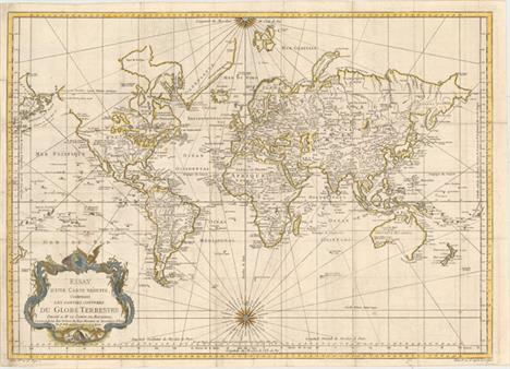
Essay d`une Carte Reduite, Contenant les Parties Connuees du Globe Terrestre... This very large and attractive world chart is drawn on Mercator`s projection. North America is shown with a prominent River of the West connecting through a series of rivers and lakes from Lake Superior to the Pacific - representing the elusive search for a Northwest Passage. The Russian discoveries in the North Pacific are shown with Alaska depicted as an island named I. Unamak. Australia is labeled Nouvelle Hollande with Terre de Diemen still linked to the mainland. New Zealand is fully formed showing both islands and there are numerous islands in the Pacific. The large, decorative title cartouche and two fine compass roses with rhumb lines make this a very attractive chart. Australia and New Zealand reflect the discoveries of Capt. Cook, but Tasmania is still attached to Australia, suggesting a publish date after 1770. Issued folding on watermarked paper with light offsetting, a few small spots, and some short fold separations and edge tears that have been archivally repaired. The sheet has been remargined with old paper at left. 20"" W x 27.9"" H Bellin, Jacques Nicolas 1748
![[On 4 Sheets] Tabula Itineraria ex Illustri Peutingerorum Bibliotheca
Nobilissimo Viro Marco Velsero... These four sheets ar](http://lot-images.atgmedia.com/SR/36385/2916721/28-2014116143850_468x382.jpg)
[On 4 Sheets] Tabula Itineraria ex Illustri Peutingerorum Bibliotheca Nobilissimo Viro Marco Velsero... These four sheets are Ortelius` scarce version of the famous Peutinger Table. These decorative maps, in a sequence of four plates, each with two strip maps, depict the imperial roads and posts within the Roman Empire throughout Europe, North Africa and Asia as far as Toprobana (Sri Lanka). The format distorts the landmasses, but provides an excellent view of the cities and roads, which include distances between the posts. The three most important cities of the Roman Empire, Rome, Constantinople and Antioch, are represented by enlarged symbols including the emperor seated on a throne. Size given is for each plate. The original parchment document for this incredible map is thought to have been made in the thirteenth century. The original now resides in the Vienna National Library, but is so damaged that the Ortelius version is now the most reliable representation. The Peutinger Table, as it is generally known, derived its name from Konrad Peutinger, who once owned the original. Ortelius had manuscript copies made in 1598 from the original scroll and supervised the engraving, but did not live to see their publication. This is the Parergon edition with Latin text on verso, printed by Balthasar Moretus and published in 1624. Clean and bright examples with nice impressions. The fourth sheet has a tiny hole in the 7th segment caused by a paper flaw, which is only visible when held to light and has been professionally reinforced on verso. 16.2"" W x 20.3"" H Ortelius, Abraham 1598

Universalis Tabula Iuxta Ptolemaeum This decorative map of the ancient world is the revised second state of Mercator`s 1578 Ptolemaic world map. The border was re-engraved, surrounded by allegorical figures representing the four elements of Fire (Zeus), Air (Hera), Water (Neptune), and Earth (Gaia), rather than the strapwork and wind head border of the earlier edition. There is a very large Taprobana (modern day Sri Lanka) in the Indian Ocean and the Indian subcontinent is severely truncated, though the Ganges is noted. Only the northern part of Africa is shown with the Nile originating in the twin lakes south of the Equator in the Lunae montes (Mountains of the Moon). A fine impression on watermarked paper with a very small hole adjacent to centerfold near bottom of map that has been professionally repaired. There are a few minute worm holes only visible when held to light. 13.7"" W x 18.7"" H Ptolemy/Mercator, 1730

Eastern Hemisphere One of the most decorative 19th century maps surrounded with fine steel engraved vignettes of the people and animals of the hemisphere and an exotic decorative border. The map is colored by continent and the Steam Route for the British Empire is shown in blue. Illustrations are by H. Warren and engraved by J. Rogers. The map was drawn and engraved by J. Rapkin. Original outline color with light toning along the centerfold. 10.1"" W x 13.1"" H Tallis, John 1850

Carte des Deux Regions Polaires Jusqu`au 45.e Degre de Latitude Interesting map of the poles that shows numerous tracks of explorers, including Tasman, Furneaux, Halley, Marion, and the 1773 expedition of Cook. There is an unusual and utterly spurious Northwest Passage shown from Hudson Bay via Wager Inlet into la Gde. Eau des Sauvages, farther down into L. de Fonte and thus to the Pacific. There are many ice floes or icebergs depicted in both poles. Engraved by H. Godin. Issued folding, now flat, on watermarked paper with light soiling. 8.7"" W x 17.3"" H Buffon, Comte de 1778

Regiones Sub Polo Arctico This important prototype map of the Arctic incorporates new information from the explorations of Capt. Thomas James with the bay named for him labeled here James his Bay. The Arctic coast of Russia provides information from Willem Barentsz` voyage and Spitsbergen is shown according the Danish expedition of James Hall. Rhumb lines radiate from the North Pole and a large title cartouche, with two figures and numerous wind heads, conveniently hides the northwest coast of America. The map is further decorated with several compass roses, ships and an additional cartouche that features men in parkas, a polar bear and foxes. Dedication to Guilielmo Backer de Corneliis (with Johanes Blaeu`s imprint), indicates this issue is from the second state of the plate. French text on verso, published between 1643-50. A nice impression with attractive old color on watermarked paper with light damp stains at right and left. 16.3"" W x 20.9"" H Blaeu, Willem 1643
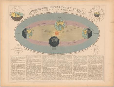
Mouvements Apparents du Soleil, Theorie des Saisons This striking and informative chart illustrates how the position of Earth in relation to the sun causes the change of the seasons. It is surrounded by four smaller figures showing the diurnal motion of Earth, the planet`s annual movement, a parallel sphere, and a right sphere. Descriptive French text appears below the diagrams. Composed and designed by H. Nicollet with text and supplemental figures by E. Soulier. Attractive original color with light toning confined to the blank margins. 18.6"" W x 23.2"" H Andriveau-Goujon, E. 1877

Revolution Annuelle de la Terre Autour du Soleil This handsome chart illustrates the movement of the earth around the sun during each month of the year. The decorative title is flanked by two more diagrams: one explains Kepler`s theory of elliptical orbits, the other shows the movement of the sun throughout the day. The illustrations are surrounded by related French text. Composed and designed by H. Nicollet with text and supplemental figures by E. Soulier. Attractive original color with some light toning along the sheet`s edges. 18.6"" W x 23.3"" H Andriveau-Goujon, E. 1877

Phases et Mouvemens de la Lune This fascinating chart focuses on the eight lunar phases. There are additional charts in the sheet`s corners illustrating the duration of the moon`s revolutions (top left), the diurnal motion of the moon (top right), a lunar epicycle (bottom left), the inclination and movement of the moon in relation to the sun and earth (bottom right), and lunar eclipse (also bottom right). The illustrations are surrounded by related French text. Drawn by E. Soulier. Original color with light toning in the blank margins. 18.6"" W x 23.3"" H Andriveau-Goujon, E. 1877

Les Noms et les Regions des Vents This is an elaborate 32-point wind rose, or compass rose. North is denoted with a fleur-de-lis, and east and south are illustrated with a lion and a sea monster. French text on verso explaining and naming the various winds. A nice impression with very light toning, a few small spots, and damp stains in the far blank margins. 3.6"" W x 3.7"" H Hondius/Bertius, 1618
![[Lot of 2] The Artificial Sphere [and] The Armillary Sphere A. The Artificial Sphere, by Thomas Salmon, from A New Geographi](http://lot-images.atgmedia.com/SR/36385/2916721/48-2014116144444_468x382.jpg)
[Lot of 2] The Artificial Sphere [and] The Armillary Sphere A. The Artificial Sphere, by Thomas Salmon, from A New Geographical and Historical Grammar..., circa 1772 (3.9 x 7.1""). This is a very decorative example of an elaborate armillary sphere enclosed in a decorative rococo-style frame. A young man sits to the left of the sphere, and a small monument lies to the right of it. Engraved by J. Hullett. Condition: A hint of offsetting from an opposing page of text. (A)B. The Armillary Sphere, by Thomas Kelly, from Ree`s Cyclopedia, dated 1817 (5.6 x 9.0""). A lovely and intricate armillary sphere is the focus of this engraving. A few of the zodiac signs are etched into the ecliptic ring. Engraved by Alexander Finlay. Condition: Light toning, faint scattered foxing, and several small abrasions in the image. (B+) See description See description 1772-1817
![[Lot of 6] Etudes Geographiques This extraordinary and complete puzzle consists of six maps which are on the face of 30 wood](http://lot-images.atgmedia.com/SR/36385/2916721/50-2014116144522_468x382.jpg)
[Lot of 6] Etudes Geographiques This extraordinary and complete puzzle consists of six maps which are on the face of 30 wooden cubes. The cubes neatly fit into the original wooden box with decorative paper label on top. Included with the puzzle are the six sample maps to assist in putting the puzzle together. These guides lay in the top of the box, held in place with a woven white string. When assembled correctly, the cubes make the following maps of the continents: A. Amerique du NordB. Amerique du Sud C. Afrique D. Asie E. Australie & Oceanie F. Europe A rare cartographic curiosity that has survived very well given its purpose as a game. The puzzle pieces are good to very good with some light soiling and staining as to be expected. The sample maps have scattered foxing and soiling more prevalent in the maps of the Americas. The box has a little shelf wear along the sides and the paper title aid on the top of the box is moderately soiled and stained. 9.6"" W x 11.5"" H Issleib, Wilhelm 1875

Americae Sive Novi Orbis, Nova Descriptio This is one of the most famous maps of America and one that had enormous influence on the future cartography of the New World. Frans Hogenberg engraved this map and it is primarily based on Gerard Mercator`s great multi-sheet world map of 1569. The map features an exaggerated breadth of the North American continent, with a lengthy St. Lawrence River reaching across the continent to nearly meet the fictitious, westward flowing Tiguas Rio. The strategically placed title cartouche hides the unknown South Pacific and therefore most of the conjectural great southern continent, which is shown attached to both New Guinea and Tierra del Fuego.This is the third of the plates that Ortelius used of the Americas, evidenced by the removal of the bulge on the southwestern coast of South America and an added cartouche in North America. Also on this plate, the Solomon Islands are noted for the first time since their discovery in 1568, and the names California, R. de los estrechos, and C. Mendocino have been added to the west coast of North America. The native name of Wingandekoa has been added to the eastern coast, originating from an unsuccessful attempt to colonize the Outer Banks by the English. Dutch text on verso, published in 1598, 1610, and 1613 with identical versos. A strong impression with superb original color on watermarked paper. There is very light soiling and professional repairs to a tiny hole along the centerfold and a short centerfold separation confined to the top blank margin. 14"" W x 19.1"" H Ortelius, Abraham 1587

America Jodocus Hondius` map of the Americas is one of the most elaborate examples of fine Dutch cartography. The decorations, including sea monsters, indigenous birds, native canoes and sailing vessels, are taken from De Bry`s Grand Voyages. Particularly notable is the scene of natives preparing an intoxicating drink made from manioc roots, which is derived from Hans Staden`s harrowing venture into Brazil. The continents are presented on a stereographic projection, which was becoming increasingly popular at the beginning on the 17th century. It presents a more correct western coastline of South America and narrows the breadth of Mexico. However, North America is still too broad and Virginia has an exaggerated coastline. Newfoundland is based on Plancius. The coastlines are fully engraved with place names. French text on verso. Full original color with a few small abrasions and light toning and soiling. There are professional repairs to two short centerfold separations at top and bottom, a tear that extends 2"" into map at bottom right, and another tear that extends less than 1"" into map at bottom left. There are a few additional professional repairs to several tiny tears and chips confined to the blank margins. 14.9"" W x 19.9"" H Hondius, Jodocus 1628

America Noviter Delineata This beautiful and popular map of the Americas was emulated by numerous cartographers and went through various editions. Originally issued by Jodocus Hondius II in 1618 with carte-a-figures borders, it was derived from two earlier maps by Blaeu. North America retains the peninsular California and the East Coast is beginning to take shape, although it still lacks detail in the mid-Atlantic region. In the Southwest, the famous seven cities of Cibola appear on the banks of a large lake. In South America, there is a large inland sea on the equator and two engraved scenes - one detailing a cannibalistic feast. Two stylized insets of the polar regions are enclosed in strapwork cartouches; the North Pole depicts Frobisher`s theory of the Northwest Passage and the South Pole shows the long-held notion of the mythical southern continent. The map is richly ornamented with a strapwork title cartouche, fleets of ships and sea monsters. Shortly after Jodocus Hondius` death in 1629 the plate passed into the hands of his brother, Henricus. The borders were removed to facilitate the smaller atlas. This is the fifth state with the imprint of Ioannes Ianssonius below the cartouche. French text on verso, published between 1652-58. Full original color with light toning and some creasing along centerfold. 14.9"" W x 19.6"" H Hondius/Jansson, 1655

Atlantis Insula a Nicolao Sanson Antiquitati Restituta; nunc Demum Majori Forma Delineata... This is Sanson`s unusual composition showing ancient geography within a contemporary outline of the Americas, which is noted in the cartouche as the mythical island of Atlantis. This is a purely topographical map and the only cities shown are Mexico City and Cuzco, the capitals of the New World. The continents are divided into ten regions, named for the ten sons of Neptune. The Great Lakes are shown but still very misshapen. A large lake in the western part of North America is the source of a river that empties into the sea between the continent and the island of California. In South America, the mythical Lake Parime appears just north of the equator, but is not named. The map includes both Asian and European coastlines and bits of New Guinea, New Zealand, and Australia. The large cartouche is surrounded by Neptune and his ten sons. This is a later derivative published in an historical atlas by the Typographia Seminary in Padua, which is indicated in the cartouche. A dark impression on a sturdy watermarked sheet with light printer`s ink residue and a few small worm holes that have been infilled with old paper. Two short edge tears in the blank margins have been archivally repaired. 15.3"" W x 21.4"" H Sanson, Guillaume 1694

Totius Americae Septentrionalis et Meridionalis Novissima Repraesentatio quam ex Singulis Recentium Geographorum Tabulis Collecta Luci Publicae Accomodavit This lovely early edition of Homann`s map of the Americas shows California as an island on the second Sanson model. The Strait of Anian forms an entrance to a potential Northwest Passage between California and the mythical Terra Esonis Incognita, which forms a nearly continuous land bridge from North America to Asia. The Mississippi River and Great Lakes show the results of the early French Jesuit explorations. A large lake in the Southeastern United States is a remnant of Le Moyne`s mythical cartography of the previous century. In South America, the Capitanias of Brazil are delineated and the Amazon and other interior features are beginning to take realistic form. The map is embellished with two fine cartouches, each with scenes of natives, Jesuits, and European merchants.See also lot 766 for Portinaro and Knirsch`s excellent reference work, which describes this map. A fine impression on watermarked paper with light soiling, a crease adjacent to centerfold, and a damp stain at top right. 18.9"" W x 22.8"" H Homann, Johann Baptist 1710

L`America Divisa ne Suoi Principali Stati di Nuova Projezione This handsome map of the Americas depicts the first voyage of Capt. Cook around South America and across the Pacific to New Zealand. In North America a variety of interesting cartographic theories are evident. The mythical Northwest Passage and the supposed discoveries of Admiral de Fonte are prominently depicted in the northern region. The interior river systems illustrates the persistent belief in a network of navigable waterways between the Mississippi and the Pacific with Baron Lahontan`s Long River (F. Longo) and Le Page du Pratz` Beautiful River (Bella Riviera). The pictorial title cartouche portrays a sleeping lion. On watermarked paper with light soiling. 12"" W x 15.8"" H Zatta, Antonio 1776

L`Amerique This handsome small map of the Americas is based on Robert de Vaugondy`s map of the same title (1762). The western coast of North America is truncated with a partial coastline and a notation indicating a possible Northwest Passage per the supposed discoveries of Admiral de Fonte. In an update from the Robert de Vaugondy original, Captain Cook`s new discoveries in the Pacific Northwest are noted as well. The British Colonies are confined east of the Mississippi River. Engraved by E. Dussy. Light scattered foxing primarily in the blank margins. 9.4"" W x 8.8"" H Robert de Vaugondy/Delamarche, 1795

Americque Septentrionale par N. Sanson d`Abbeville Geographe du Roy This is a charming little map of North America with California as an island embellished with a strapwork title cartouche. California is shown with an indented northern coastline in the Foxe form. The detached coastline to the northwest of California is named Terre de Iesso, rather than reflecting Sanson`s earlier belief that it was an extension of the American continent. The R. de Nort drains into the Gulf of California from a large interior lake in the country of Les Apaches. The two western-most Great Lakes are left open-ended and Lake Erie remains unnamed. Engraved by A. d`Winter. This is the second state with a peninsula inserted northeast of California, the Carolinas attributed to the French, and N. Iork added below N. Amstredam. A dark impression on watermarked paper. Issued folding with light soiling and a professionally repaired tear in bottom blank margin. 7.8"" W x 10.9"" H Sanson, Nicolas 1700

A New Map of North America According to the Newest Observations Attractive small map of North America that extends to include the West Indies and northern South America. The island of California dominates the west coast with the Straits of Anian, Mozeemlek Country and Parts Unknown shown above the island. The British Colonies are confined to the eastern seaboard and Florida occupies all of the present southern United States. Lake Superior is simply named Upper Lake. Lahontan`s mythical Longue River stretches between two lakes in the west, with a notation of ""Many villages on the islands"" in the most western lake. A decorative compass rose fills the Great South Sea. A fine impression with a light damp stain at top. 7"" W x 9.9"" H Moll, Herman 1716

A Map of North America With the European Settlements & Whatever Else is Remarkable in ye West Indies, from the Latest and Best Observations Cartographic myths and much else of interest fill this map of North America. It is one of the last maps to show the island of California although Seale also incorporated some information from Kino in the Southwest. He also continued to portray fanciful details from Baron Lahontan`s romantic tale of his 1688-90 travels west of the upper Mississippi River with the Longue River stretching to the Rocky Mountains. The Straits of Annian are noted, but most of the northwest is marked Parts Unknown and contains little data. Of particular note are the many Indian Towns located throughout the map. Shading designates the trade winds with directional arrows showing the course of the winds. The routes of the Spanish galleons are marked in the Caribbean. An ornate title cartouche and compass rose adorn the map. A strong impression on watermarked paper with light offsetting and a few tiny wormholes only visible when held to light. 14.8"" W x 18.5"" H Seale, Richard William 1745

Amerique Septentrionale Publiee sous les Auspices de Monseigneur le Duc d`Orleans Premier Prince du Sang This striking map of North America and the West Indies was one of the best French maps of North America prior to the French & Indian War. D`Anville was the Royal Geographer and Cartographer to the King of France. He followed Delisle as the chief proponent of scientific cartography, and his influence on his contemporaries was profound. Because he had direct access to the many official French records of North America his maps are known for their excellent detail and clearly presented information. This map provides good information in New Mexico and the Mississippi and Missouri River Valleys. A remnant of Lahontan`s fabled Grande Rivier is retained west of Lac du Bois. The region of the Ohio River Valley and below the Great Lakes reflects the superior knowledge of the French in these regions. The newly formed colony of Georgia appears squeezed between South Carolina and the Spanish claims to Florida. The map names Tecas and includes a notation on the Texas coast concerning Port Francois referring to La Harpe`s expedition. Many place names, Indian tribes, and forts are located. At upper left is an inset of Hudson and Baffin Bays. Map engraved by Guillame Delahaye, decorative cartouche drawn by Graevlot and engraved by Major. This is a later edition with the boundaries reflecting the Treaty of Paris in 1763. Printed on four sheets of heavy paper, joined. A nice impression with original color, light offsetting, and a bit of toning along the original centerfold of the right-hand sheets. Very nearly an ""A"" example. 32.8"" W x 34.1"" H Anville, Jean Baptiste Bourguignon d` 1746

Amerique Septentrionale Dressee sur les Relations les Plus Modernes des Voyageurs et Navigateurs, ou se Remarquent les Etats Unis This is the fifth state of this handsome chart of North America that adds several new elements including I. Shelrock, the Bermudas, and most importantly delineates the new United States. It also improves the configuration of the Great Lakes after d`Anville (originally drawn on the Bellin model). The large inset Partie Nord-Quest de l`Amerique shows the northwest region with much of the mythical cartography of the day including Lake de Fonte (Sea of the West) and the River of the West flows to the Pacific from a large salt lake, Tahuglauks. The decorative title cartouche balances the inset in the opposite upper corner. On watermarked paper with light soiling and some minor creases. There are several short centerfold separations and a 2"" tear in the Atlantic that have been archivally repaired. 18.8"" W x 23"" H Robert de Vaugondy, Didier 1783

Amerique Septentrionale This richly engraved map of North America shows the United States` claims into present-day Canada reflecting the Oregon boundary dispute. The Republic of Texas is shown, and Mexico`s northern border is drawn according to the Treaty of 1819 (here misprinted as 1810). Russia is in control of Alaska. The map is surrounded by beautifully engraved scenes of North and Central America including wildlife, a ship stranded in the polar sea and a Mayan temple. A nice impression with original outline color, light scattered foxing, and a few small edge tears confined to the blank margins. 11.2"" W x 17"" H Levasseur, Victor 1843
![[Lot of 3] Map of the United States [and] The Republic of Texas [and] North America These attractive maps embedded in text c](http://lot-images.atgmedia.com/SR/36385/2916721/87-201411614543_468x382.jpg)
[Lot of 3] Map of the United States [and] The Republic of Texas [and] North America These attractive maps embedded in text come from Goodrichs A National Geography, for Schools. Each sheet depicts an independent Republic of Texas and includes several small engravings to accompany the maps. A. Map of the United States, hand color (6.8 x 6.4""). Includes map on verso. Condition: Light soiling (B+) B. The Republic of Texas, black & white (3.2 x 4.3""). Includes map on verso. Condition: (A) C. North America, hand color (5.2 x 6.3""). Condition: Minor soiling in the blank margins. (A) See description 8.9"" W x 6.9"" H Goodrich, Samuel Griswold 1846

North America This is an uncommon issue of this decorative steel engraved map that features Texas shown with an enlarged panhandle that extends into New Mexico and Colorado. The boundary between Canada and the United States reflects British claims in the Oregon Territory with a line fixing the boundary south of the Columbia River. Mexico is still in control of California and the Southwest. The map is filled with forts and locates many Indian tribes. Alaska is Russian America. Several lovely vignettes appear around the continent, including Wapiti Deer, Beavers, North American Indians, Ancient Monument, Mexico, and Convoy of Diamonds. Across the top are images of Russian Cossacks (representing the Russian Possessions in Alaska), an Eskimo dog sled, and Mount Hekla, Iceland. The map was drawn and engraved by J. Rapkin; the vignettes were drawn by J. Marchant and engraved by J. Rogers. Surrounded by a delicately engraved and decorative border. Original outline color with later coloring in the border and vignettes, minor toning along sheet edges, light soiling, and fold separations at left and right confined to the blank margins. 14"" W x 9.5"" H Tallis, John 1850
![[Lot of 3] A Plan of Quebec, Metropolis of Canada. In North America [and] A New Chart of the River St. Lawrence... [and] A P](http://lot-images.atgmedia.com/SR/36385/2916721/96-2014116145418_468x382.jpg)
[Lot of 3] A Plan of Quebec, Metropolis of Canada. In North America [and] A New Chart of the River St. Lawrence... [and] A Plan of the River St. Lawrence, from the Falls of Montmorenci to Sillery... [with complete issues] This lot contains three maps pertaining to the North American theater of the Seven Years War, published in the April, September and November 1759 issues of the London Magazine. The maps, still bound in the text, include:A. A Plan of Quebec, Metropolis of Canada. In North America, by Anonymous (7.1 x 4.6""). Depicts the fortified city along the St. Lawrence River. A key at left identifies 17 strategic locations in the city including the palace, cathedral, citadel and several batteries. B. A New Chart of the River St. Lawrence from the Island of Anticosti to Lake Ontario, by Thomas Kitchin (10.1 x 7.3""). This two-part map elaborates on navigational hazards in the St. Lawrence River. The main map, the smaller continuation from Quebec to Lake Ontario, and inset of ""The Traverse or Passage from Cape Torment into the South Channel of Orleans Isle"" are each adorned with fine, decorative cartouches. Additional insets of the Bay of Seven Islands and Lake Champlain have their own compass roses. C. A Plan of the River St. Lawrence, from the Falls of Montmorenci to Sillery; with the Operations of the Siege of Quebec, by Anonymous (9.6 x 7.0""). This is a very detailed engraved map of the siege of Quebec during the French and Indian War of 1759. The map shows the positions of the two opposing forces with numerous war ships in the river surrounding the city. Admiral Holme`s Division is upstream with Admiral Saunder`s Division to the east and also up the South Channel. Locates the HMS Centurion in the North Channel just below General Wolfe`s land based camp near the Falls of Montmoreenci. At upper right is a ""Plan of the Action gained by the English near Quebec, Sep. 13, 1759."" Fancy rococo-style title cartouche. Also included in the lot are the maps The Circle of the Upper Rhine and A Chart of the Straits of Gibraltar... by Thomas Ktichin. The maps are lightly toned with scattered foxing and light offsetting. Disbound text is good with scattered foxing. See description 1759

Nouvelle Carte Particuliere de l`Amerique, ou Sont Exactement Marquees, une Partie de la Baye d`Hudson / Ou sont Exactement Marquees la Nouvelle Bretagne, le Canada, ou Nouvelle France These are the two northern sheets of the Dutch four-sheet version of Henry Popple`s important map, A Map of the British Empire in America, published by Covens and Mortier. Popple`s map was the most important map that detailed the country before John Mitchell`s map of 1755. Popple based his map on first-hand information gathered over several years at the Board of Trade and Plantations. The map, first issued in London on twenty sheets in 1733, was the first large-scale British map to provide an overall view of the eastern half of North America. As tensions grew between the colonial powers, the map became immensely influential throughout Europe and was copied by several cartographers. Each map of the four-sheet edition by Covens and Mortier carried a separate title and was surrounded by full borders, so that each sheet could be sold individually. In this example the two sheets have been joined, with the cut-off borders retained on verso.The northwestern sheet covers the Mississippi River valley from just below St. Louis, the Great Lakes, and extends to Hudson Bay. The superb detail includes forests, lakes, bogs, rivers, portages, forts, towns, and Indian villages. The Great Lakes are shown with considerable distortion and several hypothetical lakes are prominently shown. The advertising cartouche at upper left boasts of the map`s accuracy and includes a recommendation by the prominent astronomer, Edmund Halley.The northeastern sheet covers the region from Labrador to Cape Fear, North Carolina, and inland to the eastern shore of Lake Ontario. The map is filled with incredible detail including the important Grand Fishing Bank of New-Foundland. The sea is filled with a myriad of different ships and fishing boats. Original outline color with light toning and minor soiling. Several worm tracks and tears located primarily within the title and top border, as well as a 3"" worm track along border at bottom left, have all been archivally repaired. The map has been trimmed to the neatlines, and a 2"" fold separation at far left has been closed on verso with archival tape. 22.5"" W x 40.1"" H Popple/Covens & Mortier, 1737

Tierra Nueva This important early map was the first map devoted to the East Coast of North America, and the first largely devoted to Canada. The map extends from Labrador south to Florida, and as far east as the Azores. This was one of the first maps of the area to show detail, based primarily on the expeditions of John Cabot (1497-98), Giovanni da Verrazzano (1524), and Jacques Cartier (1535-36). Gastaldi was known to use the most current geographical information available, and made use of numerous sources, including the manuscript maps from Verrazzano, Maggiolo, Cabot and others.Several place names appear on this printed map for the first time and are still in use today, including Larcadia (Acadia), C. Breton, and Labrador. Verrazzano named Larcadia after the ""beauty of the trees"" and although it appears on Gastaldi`s map in the area of the Outer Banks, North Carolina, the place name moved gradually further north in later years to represent the French area around Maine and Nova Scotia. The name Tierra del Bacalaos is also derived from reports by Verrazzano, who noted the land of Bacalaia, named after a fish (likely cod). Tierra de Nurumberg was the coast discovered by Verrazzano, who reported that the natives called it Nurumbega. The depiction of Newfoundland as a group of islands, which was derived from early accounts by Cabot, was first used by Mercator in 1538 and continued to be copied until the end of the 16th century. Further south is Angoulesme (New York Harbor), named by Verrazzano after Francis I.Gastaldi`s edition of Ptolemy`s Geography was the first to include regional maps of the American continent. With maps engraved on copper, Gastaldi`s work was conceived as the first ""pocket"" or miniature atlas. His monumental work was the most comprehensive atlas produced between Waldseemuller`s Geographiae of 1513 and Ortelius` Theatrum of 1570. Italian text on verso.See also lot 769 for Nordenskiold`s excellent reference work, which describes this map. A dark impression with some printer`s ink residue, a light damp stain at bottom left, and marginal soiling. 5.1"" W x 6.7"" H Gastaldi, Giacomo 1548

Amplissimae Regionis Mississipi Seu Provinciae Ludovicianae A striking map based on Delisle`s landmark map of 1718, but covering a slightly larger area. It focuses on the Mississippi River Valley interior and Great Lakes, also detailing the Gulf Coast region, where the Mission de los Teyas is noted in present-day Texas. The map is splendidly adorned by vignettes of a buffalo and Native Americans in a cartouche filling the Atlantic, and a beaver colony at Niagara Falls under the title cartouche at upper left. Also depicted in the title cartouche is Father Louis Hennepin who explored the Great Lakes region and claimed to have reached the mouth of the Mississippi. The routes of Hennepin, de Soto and other explorers are traced in the map. Original color with light toning and scattered foxing, a centerfold separation that enters 1.75"" into the image at bottom, and a long printer`s crease at left. 19.3"" W x 22.8"" H Homann, Johann Baptist 1730

The British Governments in Nth. America Laid Down Agreeable to the Proclamation of Octr. 7. 1763 This great map was designed to illustrate the new boundaries established at the end of the French and Indian War when England came into possession of the former French and Spanish settlements in Canada and Florida. It covers the east coast from Newfoundland down the coast to East and West Florida, the Bahamas, inland including the Great Lakes and French Louisiana. The large Lands Reserved for the Indians lies west of the Appalachians. Each colony is shown with a wide engraved line. Large inset illustrates Bermuda or Summer Islands. Compass rose with the fleur-de-lis decorate the strong engraving.See also lot 766 for Fite and Freeman`s excellent reference work, which describes this map. Originally issued folding, now flat, with light soiling, a few short archivally repaired tears and fold separations, and some tiny worm holes that are only visible when held up to light. 8"" W x 9.2"" H Gibson, John 1763

A Correct Map of the United States of North America. Including the British and Spanish Territories, Carefully Laid Down Agreeable to the Treaty of 1784 This early map of the United States was created at the conclusion of the American Revolution, after the Treaty of Paris. The western boundary is along the Mississippi River. The western region is full of information up to Lake Winnipeg, with Indian names and interesting notations such as Extensive Meadows Full of Buffalos, north of the Missouri River, and Country Full of Mines, just north of Arkansas. Issued folding, now flat, with light soiling. A couple short fold separations at bottom have been archivally repaired. 12.4"" W x 17.6"" H Bowen, Thomas 1787

A New Map of Upper & Lower Canada This small map is centered on the Great Lakes and extends from Lake Winnipeg in the west to the mouth of the St. Lawrence and Anticosti Island in the east. There is nice detail of watersheds, shoreline and the southern portion of James Bay. The map locates a number of important forts including Ft. Chambly and Ft. George. Issued folding on watermarked paper with light scattered foxing. 6.8"" W x 9.1"" H Stockdale, John 1798

A Chart of North and South America, Including the Atlantic and Pacific Oceans, with the Nearest Coasts of Europe, Africa, and Asia This is the top portion of Thomas Jefferys` large and important three-part map of the Americas, compiled in 1753 by Braddock Meade, one of the most intriguing figures in British cartographic history as well as an extremely gifted mapmaker. Working under the alias John Green after serving time for defrauding an Irish heiress, Meade compiled many of Jefferys` most important maps. The portion here focuses on the Arctic explorations into Hudson and Baffin Bay and on the Pacific Northwest coast. A complete map that stands on its own, with full borders, this was partly designed to expose the errors in Delisle and Buaches map of the Pacific Northwest. This is the first map to label Bering Strait and is quite detailed, with a plethora of information on the explorers and their discoveries shown in various ways throughout the map. The tracks of Hudson and Baffin are shown and accented with sailing ships. Of particular interest are the tables at the top and left, which show the variations in latitude and longitude between Jefferys`` chart and those of Bellin, D`Anville, Moll, and Senex. There are indignant notes on the Pacific Northwest - ""These parts, as yet wholly unknown are filled up, by Messrs Buache and Delisle with the pretended discoveries of Adm. de Fonte and his Captains in 1640."" It also includes numerous notations concerning Russian explorations and presents a bulbous shaped Peninsula of the Tchuktschi whose Extent and Dimensions are unknown Alaska, named here Alaschka is shown as a large island in the Anadirskiai Islands. This is an engrossing map, and a wonderful addition to any collection of the Pacific Northwest or Arctic. Two joined sheets, as issued.Jefferys was the leading English cartographer of the 18th century, serving as both Geographer to the Prince of Wales, and later, Geographer to the King, positions that granted him access to the best surveys conducted in America. He published a series of maps of the American colonies that were among the most significant produced in the period, including the Fry/Jefferson map of Virginia, Braddock Meades map of New England, and William Sculls map of Pennsylvania and the western frontier. His successors, Sayer and Bennett, gathered these separately-issued maps together and republished them as The American Atlas. According to Ristow, ""[The atlas] was, very likely, consulted by American, English, and French civilian administrators and military officers during the Revolution."" A nice impression on watermarked paper with light soiling. There are professional repairs to two tears that enter 1"" to 2"" into map at top left and two fold separations confined to the top blank margin. The bluish shadow on the scanned image is a result of the scanner and does not appear on the map itself. 17.9"" W x 43.6"" H Jefferys/Sayer & Bennett, 1775

Carte pour Servir au Voyage des Capes. Lewis et Clarke, a l`Ocean Pacifique This is a very early map illustrating the Lewis and Clark expedition, and locates parts of their route from the mouth of the Missouri River westward through North America to the Pacific Ocean, during the years 1804-1806. Wheat notes that ""Tardieu had no Lewis and Clark map to assist him, but he apparently had at hand Meriwether Lewis`s brief letter-report to Jefferson, and he did his best to locate on his map at least a few of the Expedition`s points of geographic interest. His available topography, based as it was on Soulard, was both skimpy and erroneous, but his use of the quoted legends showed much ingenuity."" This map was published in the first French edition of a journal about the expedition written by Patrick Gass, who accompanied Lewis and Clark on their expedition. This map was not included in Gass` first edition of his journal, The Corps of Discovery, which was published in 1807. Issued folding with light offsetting, minor soiling, and a tear that enters 1"" into map at right that has been professionally repaired. Remargined at right to accommodate framing. 9.6"" W x 7.9"" H Tardieu, Jean Baptiste Pierre 1810

The United States & The Relative Position of the Oregon & Texas This interesting map depicts the United States in the midst of dramatic westward expansion, just after the annexation of Texas and just prior to the Mexican-American War. The map shows several previous and proposed western boundaries. In the Pacific Northwest there is the Line Proposed by the Convention of the 20th October 1818, the Line Proposed by the Americans in 1824 & 1826, and the Line Proposed by the English in 1826. This region was still in dispute at the time this map was published. The Line of the Treaty of Florida of the 22nd February 1819 and of 12th January 1828 forms the U.S. boundary with Mexico and the northern border of Texas. The Line Proposed to Mexico by the United Sates in 1835 shows an obscure proposed boundary roughly on the 37th parallel. Texas is shown in its largest configuration with the panhandle elongated to include the panhandle of present-day Oklahoma, and parts of New Mexico and Colorado. Mounted on linen to reinforce and repair two 5"" edge tears with a 5"" x 2"" section along and above the top left border that has been replaced with another example of the map. There is light soiling and several additional edge tears that are mostly confined to the blank margins. 15"" W x 21.5"" H Wyld, James 1845

Map of the United States Including Oregon, Texas and the Californias This unusual broadside map depicts the United States and Mexico during the Mexican-American War. It shows a small New Mexico Territory situated between the new state of Texas and the disputed area of New California. There is a red line following the Platte, Snake and Columbia Rivers labeled the ""Route of Oregon Emigrants."" Below the map is a large text panel describing the Seat of War, U.S. military history, and brief summaries of Texas, Oregon and Mexico. Full sheet with text measures 17.1 x 22.9"". Moderate toning and soiling with light overall creasing and numerous small edge tears and chips, a few of which enter the border that have been repaired on verso with old paper. There are a few pieces of masking tape on verso that have stained the sheet along the right border. 10.6"" W x 15.3"" H Haven, John 1846

Charte von den Vereinigten Staaten von Nord-America nebst Louisiana... This uncommon map depicts the United States in the early part of the nineteenth century. There are some unusual configurations west of the Appalachians including an Indiana Territory that extends from Manitoba to New Madrid, Missouri as well as an oddly shaped Ohio. Tennessee extends too far to the east and an unnamed region occupies the space between Georgia and the Mississippi River. Louisiana is still shown as a French possession and Florida is divided between East and West. Numerous Indian tribes are named and located along with good detail of the river system. On watermarked paper with light creasing at right and minor soiling primarily confined to the blank margins. 18.6"" W x 26.9"" H Weimar Geographisches Institut, 1805

United States of America This map of the United States extends west to the Rocky Mountains and provides a detailed view of the region based on information from the expeditions of Lewis & Clark and Pike. A notation at the western edge of the map shows where ""Clarks Canoes stop 3000 miles from the Mississippi."" The Missouri Territory takes in the entire northern plains region from the Mississippi to the Rocky Mountains. The new state of Missouri is presented with preliminary boundaries and Arkansas is shown at its largest extent. Today`s Minnesota and Wisconsin are here a part of North West Territory. In Texas there are a few place names including Ft. Matagorda, but Galveston is poorly located. Texas and the Southwest are a part of Mexico. One of the most interesting features of the map is the river system in the West, near the Highest Peak, where the headwaters of several major rivers all originate within a few miles of one another - Red River of California (Colorado), Multnomah (Willamette), Rio del Norte (Rio Grande), Arkansaw (Arkansas), and the Platte. This edition includes a notation in the Gulf of Mexico explaining the sources of the map and noting that recent surveys made by Major Long have been incorporated where ""the mistakes were very palpable."" Engraved by Benjamin Tanner. A nice impression with minor uneven toning, light soiling, and an edge tear at bottom that just touches the neatline and has been closed on verso with archival tape. A small piece of cello tape is located along the bottom centerfold on verso creating a faint stain on recto. 17"" W x 21.4"" H Melish, John 1827

A Map of 100 Miles Round Boston Interesting and very early Revolutionary War map extending to the Connecticut River in the west and York and Fort Stephen in the north. The map was issued in June 1775 at the outbreak of hostilities and was intended to inform the British public of the situation. There is nice detail of watershed and topography, and numerous towns, cities, and forts are located. Issued folding, now flat, on watermarked paper with light soiling and small chips in far corners at right that have been professionally repaired, with a minor amount of neatline in facsimile. Trimmed close to neatlines at right and left. 8.9"" W x 9.7"" H Anon., 1775
![[Lot of 4] Connecticut [and] Massachusetts and Rhode Island [and] New Hampshire & Vermont [and] A New Map of Maine This](http://lot-images.atgmedia.com/SR/36385/2916721/150-2014116143513_468x382.jpg)
[Lot of 4] Connecticut [and] Massachusetts and Rhode Island [and] New Hampshire & Vermont [and] A New Map of Maine This attractive lot features four maps of the northeast from Tanners Universal Atlas. Each is hand colored to show county configurations and depicts towns, roads, railroads and canals. Tables list the counties, county seats, and population statistics for each state. A. Connecticut, dated 1839 (14.7 x 12.1""). Includes insets of Hartford and New Haven. Condition: A few faint spots in the image and light toning along edges of sheet. (B+) B. Massachusetts and Rhode Island, dated 1841 (15.0 x 11.4""). Includes an inset of Boston with a numbered key listing 20 important locations. Condition: A few tiny spots in the image and mildew stains in the lower right blank margin. (B+) C. New Hampshire & Vermont, dated 1840 (11.9 x 14.6""). Condition: Light soiling and toning. (B) D. A New Map of Maine, dated 1840 (11.8 x 14.9""). Condition: Light toning and a few faint spots in the image. (B+) See description See description Tanner, Henry Schenck 1839-41
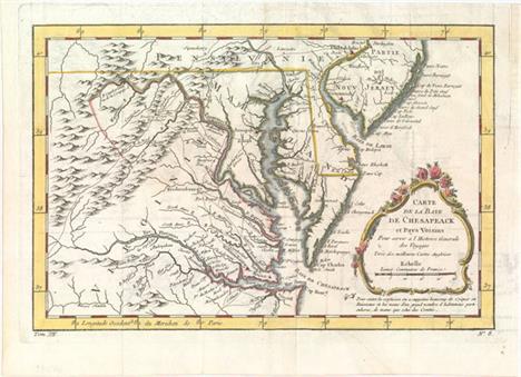
Carte de la Baye de Chesapeack et Pays Voisins pour Servir a l`Histoire Generale des Voyages Finely engraved colonial map covering most of Virginia, Maryland, Delaware with a bit of Pennsylvania and New Jersey. The interior is fully engraved with mountains and great detail along the rivers. An early network of trails and wagon roads are delineated, plus watershed and some topographical information. It extends west to beyond Fort Cumberland and locates Annapolis, Fredericksburg, Williamsburg, Norfolk, and Philadelphia. The delicate rococo-style title cartouche incorporates the distance scale. Issued folding on watermarked paper with light offsetting, a closed edge tear confined to the lower blank margin, and a binding trim at upper right replaced with old paper. 7.5"" W x 11.5"" H Bellin, Jacques Nicolas 1757

A Map of That Part of America Where a Degree of Latitude Was Measured for the Royal Society: by Cha. Mason, & Jere. Dixon This interesting little map covers the Delaware peninsula north to Philadelphia with only a few cities including Annapolis, Baltimore, and Greenwich. It locates many early settlements and shows the roads that connect them. The focus of the map is the initial measurements made by Charles Mason & Jeremiah Dixon for what has become known as the Mason-Dixon Line. These two British astronomers were employed to make this survey in order to resolve a long-standing dispute between the Calvert family, proprietors of Maryland, and the Penn family of Pennsylvania. This map, one of the first to show the results of the Mason- Dixon survey, shows this initial degree of latitude set into the context of the lands around the Chesapeake and Delaware Bays. The map is a slight variant of a map that appeared the previous year in The Philosophical Transactions of the Royal Society of London, reflecting the general public interest in this border dispute in the American colonies. Included with the lot is the complete disbound December 1769 issue of Gentleman`s Magazine. There is faint offsetting from an opposing page of text, else fine. The magazine has light scattered foxing and the first few pages are detached. 6.6"" W x 3.9"" H Anon., 1769

A Map of the Country round Philadelphia Including Part of New Jersey New York Staten Island & Long Island This Revolutionary War period map encompasses the area of Eastern Pennsylvania through Long Island and south to include Chesapeake Bay. The map was issued to illustrate the British Army`s objective of defeating Gen. Washington at Long Island and then to march to Philadelphia and put a quick end to the conflict. It is centered on Philadelphia, includes most of New Jersey, Delaware, Long Island, southwest Pennsylvania, northern Chesapeake Bay and the greater New York City area. The southern New Jersey coast is labeled Sandy Barren Desarts. The map is filled with interesting features including Indian villages, towns and cities, ferries, and roads (including the distances between towns). Adorned with a simple compass rose. Issued folding with light toning and soiling. There is minor show-through of manuscript ink on verso. 7"" W x 8.5"" H Anon., 1776
![[Lot of 2] A New Map of Virginia with Its Canals, Roads & Distances from Place to Place Along the Stage & Steam Boat](http://lot-images.atgmedia.com/SR/36385/2916721/158-2014116143526_468x382.jpg)
[Lot of 2] A New Map of Virginia with Its Canals, Roads & Distances from Place to Place Along the Stage & Steam Boat Routes [and] A New Map of Maryland and Delaware with Their Canals, Roads & Distances A. A New Map of Virginia with Its Canals, Roads & Distances from Place to Place Along the Stage & Steam Boat Routes. An attractive map with nice detail of the counties, cities, roads and railroads. At top is a profile of the Chesapeake & Ohio Canal. A table at bottom lists Steam Boat Routes - Richmond to Norfolk, Richmond to Washington, Richmond to Baltimore, Wheeling to Pittsburgh, and Wheeling to Cincinnati. B. A New Map of Maryland and Delaware with Their Canals, Roads & Distances. Fine map with good detail of the counties, cities, roads and railways. Table at top lists Steam Boat Routes - Baltimore to Norfolk, Baltimore to Philadelphia and Baltimore to Washington. A large inset depicts the city of Baltimore divided into wards with a numbered index to important buildings. Original color with minor soiling, a few small brown spots in the image, and light toning along edges of sheets. 11.3"" W x 14.1"" H Tanner, Henry Schenck 1844
![[Lot of 3] A New Map of Maryland and Delaware with Their Canals, Roads & Distances [and] Colton`s Delaware and Maryland](http://lot-images.atgmedia.com/SR/36385/2916721/159-2014116143528_468x382.jpg)
[Lot of 3] A New Map of Maryland and Delaware with Their Canals, Roads & Distances [and] Colton`s Delaware and Maryland [and] Colton`s City of Baltimore Maryland A. A New Map of Maryland and Delaware with Their Canals, Roads & Distances, by Thomas, Cowperthwait & Co., dated 1850 (14.7 x 11.5""). Attractive map with nice detail of the counties, cities, roads and railways. Table at top lists Steam Boat Routes - Baltimore to Norfolk, Baltimore to Philadelphia and Baltimore to Washington. An inset table lists the population according to the census of 1850 compared with earlier periods. Condition: Light toning confined to the sheet edges. (A) B. Colton`s Delaware and Maryland, by G.W. & C.B. Colton & Co., dated 1855 (16.5 x 13.0""). Detailed state and county map with railroads, roads, canals, cites and villages. Inset of the District of Columbia identifies 12 locations on the grid plan. Surrounded by a scroll border. Condition: Minor soiling along the top portion of the map image and light toning confined to the sheet edges. (B+) C. Colton`s City of Baltimore Maryland, by G.W. & C.B. Colton & Co., dated 1855 (16.0 x 13.0""). Detailed map of the city`s grid, divided into 20 wards. Identifies Patterson Park, Baltimore Cemetery, the Parade Ground and Fort McHenry. Surrounded by a scroll border. Condition: Light toning confined to the sheet edges. (A) See description See description 1850-55
![[Lot of 5 - Coal Fields Maps] This rare set of maps of the coal fields are the companions to the oil maps presented in Sweet](http://lot-images.atgmedia.com/SR/36385/2916721/160-2014116143531_468x382.jpg)
[Lot of 5 - Coal Fields Maps] This rare set of maps of the coal fields are the companions to the oil maps presented in Sweet`s elusive report on the oil regions of Pennsylvania and West Virginia. Each map is folding, printed in blue ink with light brown overprinting to indicate coal reserves. Each is highly detailed showing coal deposits and the transportation network of roads, railroads and canals. The lot includes the following:A. Map of Pennsylvania Shewing Routes by Railroad & Water from the Coal Fields (30.3 x 20.9""). Includes part of New York, New Jersey and Maryland. Extensive portion of western Pennsylvania indicates coal reserves. B. Map of Middle Coal Basin Compiled from the Latest Reliable Sources (28.6 x 15.1""). Extremely detailed on a scale of approximately 1.75 miles per inch, this map is centered on Mount Carmel showing much of the region covered with coal. The larger towns located are Bloomburg, Northcumberland, and Pottsville. C. Map of Southern or Schuylkil Coal Basin (28.5 x 16.9""). The detailed map is centered on Pottsville and names North Lebanon, Sunbury and Hamburg. D. Map of the Wyoming & Lackawanna Coal Basin (15.9 x 16.6""). The map is roughly centered on Pittston and names Wilkesbarre, Tuckhannock, Providence and Carbondale. E. Cumberland Coal Region Shewing the Relative Positions of the Mines (22.0 x 8.3""). This coal mining map shows Maryland and northern Virginia. The map has two panels: the first shows the Piedmont area at the confluence of the North Branch of the Potomac River and Georges Creek. The right panel depicts the various coal holdings along Georges Creek near Dans Mountain. Both name property owners, roads, topography, and railroads. Issued folding with an occasional spot of foxing and light toning along a few folds and the edges of the sheets. The map of the Schuylkill coal basin has a red ink smudge in the image. See description Sweet, S.H. 1865
![[Lot of 2] A New Map of Nth. Carolina with Its Canals, Roads & Distances from Place to Place, Along the Stage & Stea](http://lot-images.atgmedia.com/SR/36385/2916721/166-2014116143541_468x382.jpg)
[Lot of 2] A New Map of Nth. Carolina with Its Canals, Roads & Distances from Place to Place, Along the Stage & Steam Boat Routes [and] A New Map of South Carolina with Its Canals, Roads & Distances from Place to Place Along the Stage & Steam Boat Routes This fine pair of early maps depict counties, roads, railroads, canals and settlements. Tables at top and bottom display the distances along various steamboat routes to and from New Bern, Elizabeth City, Charleston and Savannah. Insets include the Gold Region to the north and east of Charlotte, the vicinity of New Bern, and Charleston. Above the North Carolina map is a profile of the Dismal Swamp Canal. Published by Carey & Hart in Philadelphia. Original color with a few spots in the image and light toning along sheet edges. 11.3"" W x 13.9"" H Tanner, Henry Schenck 1841

La Floride This influential map shows the Spanish and French possessions in the southern part of the United States. The map extends from the southernmost part of Virginia to the coast of what is now Texas. When first introduced by Sanson in 1657, this map was the first to use the name L. Erie in an atlas and to introduce several new rivers in Virginia. The French claims in the Carolinas are reasserted with the region named Floride Francoise, despite the region not having had any French presence for nearly 100 years. The place name Caroline is not related to the future English colony of Carolina. Instead it is a confusion between the French Fort Caroline on the St. Johns River, and Charlefort that was located near Port Royal. According to Burden, this is the fifth state of the map with plate number 261 at upper right.See also lot 764 for Cumming`s excellent reference work, which describes this map. An attractive example with a hint of toning and light soiling confined to the blank margins. Remnants of paper tape on verso along the top edge of the sheet. 6.9"" W x 9.9"" H Sanson, Nicolas 1738

North America Sheet XII Georgia with Parts of North & South Carolina, Tennessee, Alabama & Florida Steel engraved map that covers all of Georgia and extends west into Alabama to just beyond Montgomery. Also includes the western portions of North and South Carolina, and a large portion of Tennessee. Details county development, roads, watershed and terrain. Keyboard style border. Original outline color with light toning. Trimmed at top with some loss of title and close to the neatline at bottom, as issued. 15.7"" W x 12.5"" H SDUK Society for the Diffusion of Useful Knowledge, 1840
![[Lot of 2] A New Map of Louisiana with Its Canals, Roads & Distances from Place to Place, Along the Stage & Steam Bo](http://lot-images.atgmedia.com/SR/36385/2916721/173-2014116143554_468x382.jpg)
[Lot of 2] A New Map of Louisiana with Its Canals, Roads & Distances from Place to Place, Along the Stage & Steam Boat Routes [and] A New Map of Arkansas with Its Canals, Roads & Distances A. A New Map of Louisiana with Its Canals, Roads & Distances from Place to Place, Along the Stage & Steam Boat Routes, dated 1839 (14.2 x 11.4""). Attractive state map showing early county configurations with good detail of cities, towns, roads, canals and railroads. Features a large inset of New Orleans with a key to important buildings. Tables at left display the distances along various steamboat routes to and from New Orleans. B. A New Map of Arkansas with Its Canals, Roads & Distances, dated 1841 (11.4 x 14.3""). Fine map showing early county configurations with good detail of cities, towns, roads, canals and railroads. County configuration is up to date as of 1840 with Bradley formed from Union and Yell from Pope, Scott and Hot Springs. A table at top displays the distances along various steamboat routes to and from Little Rock. Original color with light soiling and toning along edges of sheet. See description Tanner, Henry Schenck 1839-41
![[Lot of 2] A New Map of Tennessee with its Roads and Distances from Place to Place Along the Stages & Steam Boat Routes](http://lot-images.atgmedia.com/SR/36385/2916721/174-2014116143556_468x382.jpg)
[Lot of 2] A New Map of Tennessee with its Roads and Distances from Place to Place Along the Stages & Steam Boat Routes [and] A New Map of Kentucky with its Roads & Distances from Place to Place Along the Stage & Steam Boat Routes A. A New Map of Tennessee with its Roads and Distances from Place to Place Along the Stages & Steam Boat Routes, dated 1841 (14.4 x 10.5""). This is the uncommon Tanner issue of this map; one of the few 19th century maps to show Tennessee alone. The map is inset with the regions surrounding both Nashville and Knoxville at the top, and the steamboat routes all the way to New Orleans are noted in a table to the right. Samuel Augustus Mitchell, and then Thomas, Cowperthwait & Co. purchased the plates for their editions of the Universal Atlas, but it is the earlier Tanner editions that are much more sought after. B. A New Map of Kentucky with its Roads & Distances from Place to Place Along the Stage & Steam Boat Routes, dated 1839 (13.0 x 10.7""). This highly detailed map of Kentucky illustrates roads and distances along the stage and steamboat routes. Canals, railroads, the state capital, county towns and leading roads are noted. Includes insets of Falls of Ohio, the vicinity of Clarksburg and Maysville, and the vicinity of Lexington. This is one of a few 19th century maps to show Kentucky without Tennessee. Original color with a few minor spots in the image and light toning along sheet edges. See description Tanner, Henry Schenck 1839-41
![[Lot of 3] Map of the States of Mississippi, Louisiana, and the Arkansas Territory [and] Map Illustrating the Plan of the De](http://lot-images.atgmedia.com/SR/36385/2916721/177-201411614361_468x382.jpg)
[Lot of 3] Map of the States of Mississippi, Louisiana, and the Arkansas Territory [and] Map Illustrating the Plan of the Defences of the Western & North-Western Frontier... [and] U. States` Indian Frontier in 1840... A. Map of the States of Mississippi, Louisiana, and the Arkansas Territory, by John Hinton, dated 1832, black & white (10.5 x 16.1""). A very detailed map showing Indian tribes, parishes, rivers, forts and roads. The map extends to the Sabine River with Mexico to the west. Arkansas Territory, with early county development, is included. The Mississippi Delta area is especially well-rendered, graphically depicting the swamps. Topography is shown via bold hachure and swamps and wetlands are depicted with shading. Condition: Issued folding with light offsetting and toning, as well as binding trims at the top and bottom right corners of the sheet. (B+) B. Map Illustrating the Plan of the Defences of the Western & North-Western Frontier..., by Charles Gratiot, from Sen Doc. 65, 25th Congress, 2nd Session, circa 1838, hand color (15.3 x 21.6""). This map is from the series of maps that illustrated the factious Congressional debate over the nature of the frontier defenses in the region between the Mississippi River and the Rocky Mountains. Issued under the direction of Col. J. J. Abert by W. Hood, the map depicts the states of Missouri, Arkansas, Louisiana and the Indian nations bordering them to the west. It shows the locations of many military forts and outposts from Ft. Jessup to Ft. Snelling with notations throughout concerning lands ceded by several Indian nations with the dates of the treaties. The threat posed by hostile Indians, whose numbers greatly exceeded those of the area`s settlers, resulted in a protracted Congressional debate concerning the defenses required along the frontier. A table at lower left notes the distances between forts and the equivalent ""days of march"" at 15 miles per day. Ref: Wheat (TMW) #427; Claussen & Friis #183. Condition: Issued folding with some minor foxing primarily along one fold and in the upper blank margin. (B+) C. U. States` Indian Frontier in 1840, Shewing the Positions of the Tribes That Have Been Removed West of the Missisippi, by George Catlin, circa 1876, printed color (5.4 x 8.6""). Shows the location of over twenty Indian tribes from present-day Oklahoma to Iowa that were displaced by western expansion. Condition: (A) See description See description 1832-76

Traveller`s Guide. A Map of the Ohio and Mississippi Rivers. Extending from Pittsburgh to the Gulf of Mexico This guide was printed for the use of travelers during the golden age of steamboats. Two strip maps are laid parallel to each other - one from Pittsburgh to Cairo, and the other from New Madrid to the mouth of the Gulf of Mexico. Contains an extensive mileage index on the left side of the map. Printed on yellow paper which folds into its original marbled hard covers. The inside front cover contains the signature of George Lafong, a native Virginian who went to Ohio in his early 40s and lived to be 88. Created by Joseph Duff and published by George Conclin. The map has light soiling and a few short splits at fold intersections that have been closed on verso with archival tape. Spine on hard covers has been reinforced with archival tape. 22.6"" W x 8.3"" H 1845

Geological Map of the Middle and Western States This colorful lithographed geological map, produced by the eminent American geologist James Hall, blends science and the art of cartography. Twenty-three geological types are named and differentiated using hand applied color. The map covers the region of the United States from its western boundary along the Mississippi River, east to Long Island and the Atlantic. It includes all or parts of Wisconsin, Illinois, Missouri, Kentucky, Virginia, Indiana, Ohio, Michigan, Pennsylvania, New York, New Jersey, Maryland, and Delaware. The lakes Michigan, Huron, Erie and Ontario are shown. Lithographed by Endicott of New York and signed in the plate by James Hall. A very nice example of an early and scarce geological map. Blank verso.This important regional geological map employs the ""New York System"" of stratigraphic nomenclature developed by Hall and others at the New York Geological Survey. This system emphasized the importance of paleontology for delineating geological units and introduced the concept of ""type locality,"" a primary reference location used for defining the characteristics of geological formations. This map is the first regional application of this new system, which evolved into the standard nomenclature used today for North America and much of the rest of the world. Issued folding with bold color and light toning at top and in the upper right corner where the map folds into the report. Narrow right side margin, as issued. 23"" W x 32"" H Hall, James 1843

Upper Territories of the United States This map depicts the old Northwest Territory showing the state of Ohio along with Indiana, Illinois, Michigan and Northwestern Territory. Indiana would achieve statehood later in the publication year. Detroit is shown with its Canadian neighbor, Windsor, named Sandwich, but there is no Chicago. Several frontier forts are located, but much of the territory still appears unsettled. The apocryphal mountain ridges are the most prominent topography on the map and the fictitious Phillipeaux Island remains in Lake Superior. Engraved by H.S. Tanner. Original color with light soiling and a few edge tears closed on verso with archival tape. 10.8"" W x 8.5"" H Lucas, Fielding 1816
-
534297 item(s)/page