

Southeast Asia (Indiae Orientalis, Insularumque Adiacientium Typus), Ortelius, Theatrum Orbis Terrarum, Antwerp, ca. 1570. 19.5 x 13.8”. (HC) Ortelius` important map of Southeast Asia, based on Mercator`s 1569 World map, shows how sketchy the available information was concerning the region. The East Indies are presented as a randomly scattered archipelago with Java and Borneo particularly misshapen. Taiwan is mapped for the first time as I. Fermosa in the `tail` of kite-shaped Japan`s Lequaio islands. The fictitious Chyamai lacus is the source of a network of major rivers in Southeast Asia. Beach pars, a presumed promontory of the great southern continent based on Marco Polo`s account, protrudes into the bottom of the map. In the upper right corner, America makes an appearance with the three coastal cities of Quivira, Cicuie, and Tiguex. Near the shore lies a ship being menaced by a pair of sea monsters, while twin mermaids preen before each other near the Ladrone Islands. Latin text on verso, published between 1570-73. Ref: Van den Broecke, no.166; Suarez, pp 164-69. Lovely old color on watermarked paper with minor soiling and a professionally repaired centerfold separation that enters 1" into map at bottom. There is a tear in bottom blank margin that has been closed on verso with archival tape, and a chip at the upper right corner in the blank margin has been replaced with old paper. (+B)
We found 596772 price guide item(s) matching your search
There are 596772 lots that match your search criteria. Subscribe now to get instant access to the full price guide service.
Click here to subscribe- List
- Grid
-
596772 item(s)/page
![Southeast Asia (Asiae XI Tab), Ptolemy/Mercator, Theatrum Geographiae Veteris…, Leiden, [1618]. 13 x 13.5”. (BW)](http://lot-images.atgmedia.com/SR/36385/2862480/778-20125101773_468x382.jpg)
Southeast Asia (Asiae XI Tab), Ptolemy/Mercator, Theatrum Geographiae Veteris…, Leiden, [1618]. 13 x 13.5”. (BW) Fine Ptolemaic map of the region of Thailand and Malaysia. The map shows an oddly shaped peninsula to the east of the Ganges and the Sinus Magnus (South China Sea), with a landmass to the east of that. This depiction is the legacy of Ptolemy`s idea of a landlocked Indian Ocean. Although he is most renowned today for the projection he popularized and for first using the term Atlas for a collection of maps, Mercator devoted much of his life to his Ptolemaic maps. The maps were beautifully engraved as nearly as possible to their original form and embellished with fine cartouches and cultural scenes. This map includes a caravan, camels, ships and boats. Ref: Mickwitz & Miekkavaara (Nordenskiold) no.232-27. There are two tiny holes near the centerfold, light damp staining and some scattered foxing primarily in the blank margins. Right margin is trimmed close to the neatline. (B)

Southeast Asia (India quae Orientalis dicitur, et Insulae Adiacentes), Blaeu, Amsterdam, ca. 1635. 19.8 x 16.2”. (HC) This handsome chart of Southeast Asia includes one of the most detailed images of the sphere of operations of the trading empire of the Dutch East India Company. It extends from India to New Guinea and parts of northern Australia, and north to the southern coast of Japan with a portion of Korea, which is named as an island. This map was a vast improvement over Blaeu`s map of the Asian continent and was presented on Mercator`s projection in the style of navigational charts. Significantly, it delineates a more correct outline of New Guinea and is the first atlas map to include the discoveries made by the Dutch in the Gulf of Carpentaria -- thus the first recorded European contacts with Australia. Richly embellished with sailing ships, compass roses and three sumptuous cartouches. The cartouche at lower left features the coat of arms and dedication to Laurens Real, Governor General of the East Indies, 1616-18. French text on verso. Ref: Suarez (SEA) p. 201; MCC-60 Tooley (Australia) no.226. Attractive color with a few minor spots, professionally repaired centerfold separations, and marginal soiling. (+B)
![Southern Asia ([On 2 Sheets] The East Indies, with the Roads…), Jefferys/Laurie & Whittle, London, 1794. 54.3 x 21&](http://lot-images.atgmedia.com/SR/36385/2862480/796-201251017817_468x382.jpg)
Southern Asia ([On 2 Sheets] The East Indies, with the Roads…), Jefferys/Laurie & Whittle, London, 1794. 54.3 x 21”. (HC) This impressive wall-sized map by Jeffreys was the most detailed to date. It extends to include parts of present-day Pakistan in the west to Burma and the Andaman Islands in the east, and reaches up to Tibet in the north. The map was of great importance during the British expansion in the area, and contains a combination of detailed, well-explored areas and large tracts of unknown land. Southern India, Sri Lanka and Bahar Bengal (Bangladesh) are well defined, with details of roads, caravan routes, oases, temples, cities, treaty lines, archeological sites, mountain ranges, lakes, swamps and rivers. The map is dedicated to the Directors of the East India Company. Printed from four plates, joined in two horizontal sheets. Later issue of the map first published in 1763. Issued folding, with light offsetting and minor soiling. There are a few tiny holes at fold intersections and some fold separations, most of which have been closed on verso with archival materials. Trimmed close to neatline at top. (B)

Indian Ocean (Carte Reduite de l`Ocean Oriental, depuis le Cap de Bonne Esperance, jusqu`a l`Isle Formose), Apres de Mannevillette, Le Neptune Oriental, Paris, 1775. 27.8 x 19.8”. (HC) A French sailor and hydrographer, D` Après de Mannevillette (1707-1780) used new instruments to correct the latitudes measured by previous explorers. His atlas Le Neptune Oriental, first published in 1745, was considered a major achievement and an indispensable resource for navigators. This uncommon sea chart shows great detail of the coastline from Cape Good Hope in Southern Africa north to the Arabian Peninsula, east to India and south to Australia. Printed on heavy watermarked paper with a few light spots and stains primarily in the blank margins. Remnants of hinge tape on verso. (+B)

Africa (Africae Nova Tabula), Hondius, Amsterdam, 1631. 19.5 x 15”. (HC) This richly ornamented map of the continent is Henricus Hondius` issue of Jodocus Hondius` map, but without the decorative borders that were masked in order to fit the map into an atlas format. The geography is largely speculative and follows Blaeu`s map of 1617 with the Cuama River originating in the mountains rather than in the Sachaf Lake below the Mountains of the Moon (Lunae Montes). The origin of the Nile conforms to the Ptolemaic tradition of the two twin lakes south of the equator. The Kingdom of Monomotapa occupies a large area of southern Africa. Ornamentation includes a wreath-style title cartouche, sailing ships, flying fish, various sea monsters and Neptune consorting with a comely mermaid. Elephants, lions, zebras, ostriches, and even a dragon occupy the interior. From the first Latin edition published in 1631 with no text on verso. Ref: Betz no.58.3; cf. Norwich no.34. There are professionally repaired centerfold separations that enter 4" at top and 2" at bottom of map and a repaired tear at upper right that passes 3/4" beyond the neatline. There are two small worm holes along the equator that have also been professionally infilled, with a minute loss of image. (+B)

Africa (L`Afrique, Dressee sur les Observations de Mrs. de l`Academie Royale des Sciences et quelques autres & sur les Memoires les plus recens), Delisle/Schenk, Amsterdam, 1708. 22.2 x 17.5”. (HC) This striking map is one of the landmarks in the history of charting Africa. It was first issued by Delisle in 1700 and is distinguished by his scientific approach to cartography. Most of the maps of Africa issued in the eighteenth century were based on this map or his revision in 1722. The Nile is correctly shown with its origins in Abyssinia, and there is no line connecting the Niger and Nile Rivers. The Senegal River is also shown more correctly, originating in West Africa and flowing west into the Atlantic. The Congo or River Zaire, R. du Saint Esprit and the Zambeze appear in the south, along with the Portuguese settlements of Sean, Tete and Chicora. Several native kingdoms are named, as well as the sites of various mining districts. The title cartouche is beautifully decorated with three elephants, an ostrich and a native wrestling a crocodile. Ref: Betz no.174; Norwich no.59. Bold original color with a few minute cracks due to the oxidation of green pigment, which have been closed on verso with Japanese tissue. There is faint offsetting and a few unobtrusive spots. There are short centerfold separations at top and bottom, far from map image. (+B)

Africa (Carte d`Afrique Dressee pour l`usage du Roy…), Delisle, Atlas Geographique et Universel, Paris, 1722. 24.8 x 19.3”. (HC) First edition of this important, updated map of the continent and Madagascar detailing all of Africa, divided into kingdoms and tribes. The Senegal and Niger Rivers are correctly separated. In the southeastern portion of the continent Lake Moravi is shown well inland from Zanzibar. Two decorative cartouches grace the map. This is not the more common Covens & Mortier issue. Ref: Norwich no.78. Original outline color on watermarked paper. The sheet is lightly toned with occasional small spots and some manuscript ink notations in the upper right blank margin. (+B)

Northwest Africa (Barbariae et Guineae Maritimi a Freto Gibraltar ad Fluvium Gambiae cum Insulis Salfis Flandricis et Canaricis), Renard/De Wit, Amsterdam, ca. 1715. 22 x 19”. (HC) This decorative sea chart of the Barbary and Guinea coasts extends to include part of the coastline of Portugal and Spain. Two compass roses orient north to the left, and there is good detail of the Azores, Madeira, Canary, and Cape Verde Islands. Additional detail is confined to the coasts with numerous place names. The interior of Africa is filled with a decorative title cartouche depicting fat-tailed sheep, a lizard, and snakes in the foreground, with African pirates, merchants and slave-traders. The man at front right holds a scimitar in one hand and a decapitated head in the other hand. The map is further embellished by several sailing vessels, while others are engaged in battle. This is the Renard edition of the map that was first published by Frederick de Wit, circa 1675. Ref: cf Norwich no.252. There is some minor toning and small worm holes and tracks (primarily along centerfold) that have been professionally infilled, with a small amount of image in facsimile. (+B)
![North Pacific Ocean ([Lot of 3] Carte Generale des Decouvertes de l`Amiral de Fonte… [and] Nouvelle Representation des](http://lot-images.atgmedia.com/SR/36385/2862480/830-2012510171048_468x382.jpg)
North Pacific Ocean ([Lot of 3] Carte Generale des Decouvertes de l`Amiral de Fonte… [and] Nouvelle Representation des Cotes Nord… [and] Partie de la Carte du Capitaine Cluny…), Robert de Vaugondy, Diderot`s Encyclopedia (Supplement), Paris, [1772]. x ”. (BW) Three great maps from this interesting series prepared by Didier Robert de Vaugondy. A. Carte Generale des Decouvertes de l`Amiral de Fonte, et Autres Navigateurs Espagnols, Anglois et Russes pour la Recherche du Passage a la Mer du Sud, dated 1752 (15" x 11.3"). This is one of the more remarkable combinations of fact and fiction ever published. This map of the North Pacific and Northwest had as its source a 1708 article in the Monthly Miscellany that purported to be a newly discovered account of a voyage in 1640 by the Spanish Admiral, Bartholomew de Fonte. Thereafter, the newly presented information was changed and elaborated upon, notably by this series of maps which appeared in Diderot`s Encyclopedia. In its concept, it promoted the hopes of a Northwest Passage and depicts the existence of Mer de l`Ouest or the Sea of the West. The tracks for the Russian exploration in 1741 and other explorers are traced in the Pacific. Inset at upper left is a small map, "Carte dressee Sur la lettre de l`Amiral de Fonte par l`Ecrivain de la Californie" detailing the purported track of Admiral de Fonte. The title credits Delisle as the source for the map. There was much controversy at the time regarding the veracity of the voyages by de Fonte. In 1750, Joseph-Nicolas Delisle presented a paper and map at the Academy of Sciences in Paris that consolidated the vast amount of geographical information he had acquired in Russia. The paper caused a sensation, but the map, drawn by Philippe Buache and designed to show the "coherence of Russian discoveries with those of de la Fuente" (de Fonte), was met with skepticism. Delisle hired Bellin to re-work the map, presenting it to the Academy in 1752. That same year an annoyed Buache drew his own map and presented it along with a paper to the Academy. The controversy was further enflamed by Robert de Vaugondy`s own presentation to the Academy the following year when he expressed his doubts about the truth of de Fonte’s voyages and criticized the maps illustrating it. See Pedley pages 74-78 for more on the politics and personalities in this fascinating story. Ref: Hayes pp. 26-27; Pedley no.454. Condition: Watermarked paper with wide margins, light centerfold toning and a spot in inset map at top left. (B+) B. Nouvelle Representation des Cotes Nord et Est de l`Asie, pour Servir d`Eclaircissement aux Articles du Supplement de l`Encyclopedie qui Concernent le Passage aux Indes par le Nord. Gravee sous la Direction de Mr. de Vaugondy en 1772, dated 1772 (14" x 11.3"). Interesting map of the northeast coast of Asia depicting Kamchatka, Japan and Korea. It also shows part of what is present-day Alaska. The Tchutski (Chukotskiy) Peninsula stretches very close to the American landmass, hinting at a possible land bridge. Within the larger map are two insets (one within the other). The insets represent an evolving understanding of the geography of Kamachatka, with the map being the latest iteration. The first inset, No. 1, was completed by Abu al-Ghazi Bahadur, who was the ruler of Khiva in present-day Uzbekistan for 20 years. Ref: Pedley no.402. Condition: Watermarked paper with wide margins and a spot in bottom blank margin, far from map image. (A) C. Partie de la Carte du Capitaine Cluny Auteur d`un ouvrage anglois intitule American Traveller, dated 1769 (19.5" x 11.5"). While this fascinating map covers the Arctic from Asia through Europe, the focus of the map is the Arctic region of North America. The most important feature of the map is the early depiction of what is present-day Alaska, patterned after Muller`s epic map of 1750 that was the first to show the Russian discoveries, also noted here. A very interesting Northwest Passage is shown going from Repulse Bay in the north part of Hudson`s Bay into the Arctic Ocean at Cape Fowler. (19 x 11.5") Ref: Pedley no.460. Condition: Watermarked paper with faint toning along folds, else fine. (A) See description. ()

Birds (Der Kleine Sperling), Seligmann, Sammlung Verschiedener Auslandischer und Seltener Vogel, ca. 1776. 8.5 x 12”. (HC) This beautiful engraving is a German version of the work of Mark Catesby, who has been called the "Father of American Ornithology" due to his Natural history of Carolina, Florida and the Bahama Islands, the first natural history of American flora and fauna. This scene depicts a Savannah Sparrow and a large moth with purple Carolina bindweed (Convolvulus Carolinensis). The sheet measures 10 x 15". Johnann Seligmann (1720-1762) was a Nuremberg engraver and publisher. He published a German translation of Catesby’s work between 1749 and 1776. Nice strong impression and lovely original color with just a few minor spots and light soiling along the edges. (A)

Military, Naval Battle (View of the Landing at Rangoon of Part of the Combined Forces From Bengal and Madras, Under the Orders of Sir Archd. Campbell, K. C. B. on the 11th of May 1824), ca. 1825. 14.5 x 11.5”. (HC) This detailed aquatint shows a battle scene at Rangoon, Burma which was part of the first of three Anglo-Burmese Wars during the 19th century. In this campaign, the British sent thousands of troops under General Archibald Campbell and numerous ships under Captain Frederick Marryat to attack Rangoon by sea. The campaign resulted in the capture of the city on May 11th, 1824.. Sporadic fighting continued in 1825 and 1826, with the Burmese finally surrendering on February 24th, 1826 ceding control of Assam, Manipur, Cachar and Jaintia as well as Arakan and Tenasserim. Drawn by Lt. Joseph Moore, engraved by H. Pyall and published in Eighteen Views taken at & Near Rangoon. There is one minute hole in the sky only visible when held to light. (A)
![Ships ([Lot of 2 - Ships]), Mallet, Beschreibung des Gantzen Welt Kreises…, Paris, ca. 1719. 5 x 7.8”. (HC) This](http://lot-images.atgmedia.com/SR/36385/2862480/857-2012510171227_468x382.jpg)
Ships ([Lot of 2 - Ships]), Mallet, Beschreibung des Gantzen Welt Kreises…, Paris, ca. 1719. 5 x 7.8”. (HC) This lot includes two engravings of ships from the first volume of Mallet`s Beschreibung des Ganzen Welt Kreises…. The first, engraved by Vogel, depicts a ship firing a cannon with several rowboats alongside. The various sails are lettered, with a key in French and German at top. The second engraving depicts several ships in stormy weather. Ref: cf. Pastoureau, Manesson-Mallet Tome I, [92] & [96]. Marginal soiling and remnants of hinge tape on verso. The first engraving has a minor damp stain in top blank margin, far from image. The second engraving has a small chip in bottom right corner, also far from image. (A)
![Incunabula (CCI [Crucifixion of William of Norwich]), Schedel, Liber Chronicarum, Nuremberg, [1493]. 12 x 17”. (HC) Ful](http://lot-images.atgmedia.com/SR/36385/2862480/882-201251017141_468x382.jpg)
Incunabula (CCI [Crucifixion of William of Norwich]), Schedel, Liber Chronicarum, Nuremberg, [1493]. 12 x 17”. (HC) Full sheet of German text with the woodcut illustration of the crucifixion of William of Norwich, a Christian boy supposedly ritually tortured and crucified by the Jews. This medieval myth was the first recorded instance of the blood libel in Europe against Jews. The balance of the verso contains portraits of Hildegard (Hildegardis), Gratian (Gracianus), bishop Peter Lombard, and Petrus Comestor. The recto depicts portraits of Conrad III (1093-1152), king of Germany, and Louis VII (c. 1121-1180), king of France. Watermarked paper with a few spots and marginal soiling. (+B)
![Incunabula, Hungary and Toulouse, France ([Lot of 2] Folio CCLXVIII [and] Folio LXXI), Schedel, Nuremberg Chronicle, Nurember](http://lot-images.atgmedia.com/SR/36385/2862480/887-2012510171419_468x382.jpg)
Incunabula, Hungary and Toulouse, France ([Lot of 2] Folio CCLXVIII [and] Folio LXXI), Schedel, Nuremberg Chronicle, Nuremberg, [1493]. 11 x 16”. (BW) This lot includes two folio sheets from a Latin edition: A. Folio CCLXVIII. The verso depicts an imaginary view of the Hungarian countryside with several medieval villages and hilltop castles. B. Folio LXXI. A panel of portraits on recto represent several philosophers, including Themistocles, Aristides, and Anaxagoras. The large view on the verso of the city of Toulouse (Tolosa) does not show an authentic city view, but is in fact the same woodcut also used to portray Troy. A few faint spots. The first sheet also has a damp stain confined to left blank margin. (+B)

Atlases (New Universal Atlas Containing Maps of the Various Empires, Kingdoms, States and Republics of the World…), Thomas, Cowperthwait & Co., Philadelphia, 1854. 14 x 17.5”. (HC) The title continues "With a special map of each of the United States, Plans of Cities &c. Comprehended in seventy five sheets and forming a series of one hundred and twenty two maps plans and sections." This famous and highly sought-after atlas is complete with 75 map sheets of the world, North America and the other continents, Oceanica, the United States and its territories, and numerous city plans. The atlas concentrates mainly on the American continents, and features many important and desirable maps. The map of Texas is one of the most influential atlas maps of the period. It depicts the new boundaries that were determined by the Compromise of 1850. The organized counties extend only to Cooke in the north and Kinney in the southwest. The western edge of the frontier is marked with a line of army forts separating the settled region from the vast area noted as rolling table lands and desolate plains Destitute of Timber. This area is largely the range of Apache, Kiowa, Comanche and Lipan Indians. Wagon roads, springs, and trails are identified, including the Comanche War Trail, Connelly`s Trail and the Emigrant`s Route. Tiny flags locate important battlefields in both the Texas war for independence and the Mexican American war. Descriptive explanations and notes make this map an interesting study. A table provides statistics according to the Census of 1850 including the population by ethnic groups, e.g. "Free Colored males" is given as 171. There are insets of Northern Texas, noting the northern boundary at Lat. 36 30`, as resolved in the Compromise of 1850, and the vicinity of Galveston City. The spectacular map of the West has a large Oregon territory extending to the Continental Divide, the huge Utah Territory extends from California to Indian Territory, and New Mexico occupies all of the Southwest with a pre-Gadsden Purchase border. The double-page map of the United States features the same borders in the West, plus a large inset map of the Gold Region of California. The map of Minnesota features the large territories of Pembina and Blue Earth extending to the Missouri River. The frontispiece is a hand colored, engraved diagram showing the lengths of rivers and heights of mountains. The title page includes a fine, early chromolithographic image by P.S. Duval titled First Landing of Columbus in the New World, which shows Columbus and his crew giving thanks to God for their safe journey. Folio, frontis, chromolithographed pictorial title page depicting Columbus` arrival in the New World, table of contents printed in red and gilt color, 74 map sheets comprising 70 single-page maps, 3 double-page maps (US, New York and Europe) and the thematic plate. Bound in half red leather over marbled paper boards. Red leather label on front cover with gilt title and design. Published by Thomas, Cowperthwait, & Co. No. 253 Market Street, Philadelphia. This is an increasingly difficult to find atlas complete with all its maps. Maps have original color and are mostly in near fine condition with some in very good condition with occasional light foxing. Toning is primarily confined to blank margins, although a few maps have overall light toning. The binding is very loose and the spine is missing. The covers are detached and show moderate wear and rubbing. This example would benefit greatly from professional rebinding. (+B)
![Exploration and Surveys ([Lot of 2] Astoria, or Anecdotes of an Enterprise Beyond the Rocky Mountains Vol. 1 & Vol. II),](http://lot-images.atgmedia.com/SR/36385/2862480/908-2012510171543_468x382.jpg)
Exploration and Surveys ([Lot of 2] Astoria, or Anecdotes of an Enterprise Beyond the Rocky Mountains Vol. 1 & Vol. II), Irving, Philadelphia, 1836. 5.5 x 9”. (BW) This is the first edition, first state of this "classic account of the first American attempt at settlement of the Pacific Coast" (Howes). Irving`s history of John Jacob Astor`s attempt to bring American fur trade to the Pacific was based on revised transcripts of the journals of Robert Stuart , Wilson Price Hunt and Ramsay Crooks. Among these were " journals and letters narrating expeditions by sea, and journeys to and fro across the Rocky Mountains by routes before untraveled, together with documents illustrative of savage and colonial life on the borders of the Pacific." Included in the 2nd volume is the map Sketch of the routes of Hunt and Stuart. While there is not much detail, Wheat says, "for what it purports to be it is an excellent map." The title pages have a stamp of the "Philermenian Society" which was a Brown University Literary Society. First edition, with the copyright notice and "Henry W. Rees, Stereotyper" on the verso of the title-page of volume one. Volume 1 contains 285 pp. and volume 2 has 279 pp. Both volumes are bound in their original half leather with marbled paper boards. Gilt title on embossed spine. Ref: Howes I-81; Wheat (TMW) no.419. The map has some light foxing and minor extraneous creasing near the folds, as well as several archivally repaired fold separations and short tears. The text pages are lightly foxed and the covers are somewhat worn, but the books are still quite presentable. (B)

Exploration and Surveys (Exploration of the Red River of Louisiana in the Year 1852), Marcy, Sen. Exec. Doc. 54, 32nd Congress, 2nd Sess., Washington D.C., 1853. 6.3 x 9.3”. (BW) The U.S. Army expedition commanded by Captain Marcy was the first to discover the source of the Red River. His report abounds in topographical and geographical detail with attention also paid to the customs of the native people in the southern plains. It includes an impressive scope of data, including meteorological and natural history information, with emphasis on geology, paleontology, reptiles, fish, insects and botanicals. Sixty-four beautifully lithographed plates are included, as well as a hand-colored fold-out geological chart of the region. The two folding maps accompanying the report are not present. Hardbound in embossed green cloth with gilt title on spine. 320 pp. 8vo. Ref: Wagner-Camp no.226.1 Scattered foxing and toning throughout. Covers and spine are bumped and worn, and the hinges are starting. (B)
![History Books ([Lot of 2] Political Essay on the Kingdom of New Spain Volume I and Vol. II), Humboldt, [1811]. 5.5 x 9”](http://lot-images.atgmedia.com/SR/36385/2862480/916-201251017168_468x382.jpg)
History Books ([Lot of 2] Political Essay on the Kingdom of New Spain Volume I and Vol. II), Humboldt, [1811]. 5.5 x 9”. (BW) Friedrich Wilhelm Heinrich Alexander von Humboldt is one of the most important figures in the scientific discovery of the Americas. Humboldt traveled through the Spanish possessions in America from 1799-1804 under the patronage of the Spanish Crown and was granted access to the archives of the Spanish-American colonies. During his travels he made numerous scientific observations and accumulated data on the customs, behavior, intellect and social arrangements of the indigenous population as well as investigated geographic, geologic, political, commercial and agricultural aspects of the society. This two volume book, translated from French by John Black, comprises the first scientific description of the American Southwest with a wealth of information on California and Texas. This edition was issued without maps. 8vo., 221+377 pp. Full calf with gilt bands and red Moroccan title label on spine. Toning and foxing throughout the text. Covers and spine and somewhat worn and bumped. (B)
![Reference Books, Incunabula (The Making of the Nuremberg Chronicle), Wilson, Amsterdam, [1978]. 10 x 13.8”. (BW) Detail](http://lot-images.atgmedia.com/SR/36385/2862480/921-2012510171627_468x382.jpg)
Reference Books, Incunabula (The Making of the Nuremberg Chronicle), Wilson, Amsterdam, [1978]. 10 x 13.8”. (BW) Detailed examination of the making of this important early illustrated book taken from surviving page layouts, original contracts for the illustrations, contracts for printing, etc. It includes a history of the printer, Anton Koberger, and a list of known copies of the first Latin and German editions. The text of this study of the Chronicle`s production combines scholarship with wit, providing a fascinating view of the incunabula period. Introduction by Peter Zahn and published by Nico Israel, 253 pp., illustrated, including color plates. First edition, second printing. Hardbound in gray cloth, pictorial dust jacket. (+A)


The 1914-15 Star to 9226 PTE T.MORRIS. R.FUS: The 1914-18 British War Medal and The 1914-19 Victory Medal to SR-9226 PTE.T.MORRIS. R.FUS. with a ribbon bar and the First World War period bronze memorial plaque detailed THOMAS MORRIS, with a card case, who died 20th December 1914 and is buried at The Ration Farm Military Cemetery.


A collection of mostly militaria, including; two brass First World War period shell cases, two side caps, a belt, an armband detailed FIRE GUARD, various cloth and textile badges, medal ribbons, paperwork and ephemera, a quantity of uniform buttons, mostly relating to Fire Brigades, various cap and other badges, a Polish medallion, cased, enamelled and other lapel badges, a small locket containing photographs of ARRAS, a brooch detailed BAPAUME, a Third Reich knife, epaulettes, a book shaped lighter, RAF buttons, tokens and sundry.

A gentleman`s steel OMEGA SPEEDMASTER PROFESSIONAL bracelet wristwatch, the signed black dial with three subsidiary dials, luminous baton numerals, centre seconds and with an outer Tachymetre scale, the case back detailed THE FIRST WATCH WORN ON THE MOON, the OMEGA bracelet with a foldover clasp, with a red OMEGA case and box.


*Wellingborough Rail Crash 1898. A black and white photograph of the wreckage with onlookers, 24cm x 30cm, together with another of the damaged the M.R. locomotive and wagon with workers standing before it, 24cm x 30cm, each with mount printed `L. Brightwell`, `Wellingborough` and in a contemporary oak frame. In the evening of 2nd September 1898 a postman at the Wellingborough railway station brought a mail cart to the station ready for the 20.22 train. Having collected a luggage trolley he made his way down to the platform having to unlock the gate first, the trolley began to roll down the unnecessarily steep platform and before he could stop it, it rolled onto the tracks. In a desperate bid to clear the trolley off the tracks the foreman and the postman could not move the 230kg trolley and the tracks were already set for the non-stop 19.15 London St Pancras to Manchester express , they had to jump for their lives as the locomotive derailed on hitting the trolley, both enginemen and five passengers were killed. (2)
*Bachmann Model Rail. No. 32-752 (Class 57/0 diesel 57602 First Great Western), 32-800 (Class 47 diesel D1500 two-tone green half yellow ends four digit head code), 32002 (5960 `Saint Edmund Hall` BR black), 32-825 (Ivatt class No. 2 MT 2-6-0 no. 46521 BR lined green L/crest), 32-776 (class 37/diesel BR green split head code B6707), 32-507 (standard class 5 MT no. 73050 BR black L/crest BR 1G tender (weathered) (40 years end of steam), 32075A (class 56 XX tank 6600 GWR green), 31-831 (class 43 XX 4358 BR green early emblem), 31-976 (BR standard class 3 MT tank 82005, BR lined green late crest) (9)
[Titanic]. Lloyd`s Register of British and Foreign Shipping. United with the Underwriters` Registry for Iron Vessels in 1885, from 1st July 1912, to the 30th June 1913, vol. 1 - Steamers, Sailing Vessels, and Owners, published 1912, half-title and preliminary leaves sl. creased, three parts with supplement to the first part, some printing in red, abbreviations and table of equivalents pasted to front and rear pastedowns, some spotting and occ. soiling and age creasing, lacks conjugate leaf before half-title (blank?), orig. morocco gilt, wear to spine and extremities, joints cracked, thick 4to. This is the only edition of Lloyd`s Register to list RMS Titanic, giving tabular details of number in book, official number, code letters, steamer`s name, material, rig, &c., master (E.J. Smith), number of decks (`5 dks amidships, 7 dks in No. 1 hold, Elec. light Ref. Mchy. 6 dks in other holds, Sub. Sig. Wireless`), registered tonnage, particulars of classification, built date, by whom and where, owners, registered dimensions, deck erections &c., port of registry, flag, and engines. This copy also notes in black print capital letters adjacent to the name Titanic `(Struck iceberg and foundered 4, 12)`. The volume also lists RMS Carpathia with its Captain A.H. Rostron, rescuers of survivors from RMS Titanic. Rare. (1)

*Red Star Line. A folding paper fan for the Red Star Line, c.1890s, the chromo. leaf depicting a lady and a small girl observing a steam liner through binoculars, with the words `Antwerpen - New York` and `Red Star Line` printed in red, 1` tear in upper edge, mounted on silver-patterned shaped wooden sticks, 24cm (9.5ins), together with A folding tissue fan for the Red Star Line, c.1930s, the leaf composed of ten scallop-edged ovals of tissue paper, stencilled with the Red Star flag in the centre, with gold flowers and leaves outlined in glitter, the first oval with `Red Star Line Antwerpen` in embossed gilt lettering, mounted on white-painted wooden sticks, 21.5cm (8.5ins), together with three other Red Star Line fans, all folding printed paper fans mounted on wooden sticks, two printed in blue and white with Dutch folk observing a steam liner, c.1910 (one of which has the US flag on the verso), and the other a fontage fan depicting a lady and gentleman in evening dress, c.1930s (5)
Cary (A.D.L. & McCance, Stouppe). Regimental Records of the Royal Welch Fusiliers (Late the 23rd Foot), 4 vols, 1921-29, colour & b & w plates, maps and diagrams to text, orig. blue cloth gilt with red dragon to upper covers, rubbed with a little fraying to extrems, 8vo, together with Arthur (Captain Sir George), The Story of the Household Cavalry, 3 vols, 1909-26, photogravure frontis. to vols 1 & 3, numerous colour and b & w plates, ink stain to fore-margin of last few leaves in vol. 1, bookplate of the Earl of Arran, orig. gilt dec. blue cloth, sl. rubbed and marked, 8vo, and Liddell (Col. R.S.), The Memoirs of the Tenth Royal Hussars (Prince of Wales` Own), 1891, photogravure frontis. of the Prince of Wales, 14 chromo. plates, orig. cloth gilt decorated with Prince of Wales insignia, split at the joints with contents very loose, 8vo, and Wheater (W.), A Record of the Services of the Fifty-First (Second West York) the `King`s Own Light Infantry` Regiment, 1870, albumen photo. frontis., modern maroon cloth gilt, 8vo, plus Nicholson (Col. G.W.L.), The Gunners of Canada, 2 vols, 1967-72, numerous plates and folding maps, orig. cloth gilt, some marks, 8vo, plus other mostly British regimental histories, some modern publications (27)
Edye (Major L.). The Historical Records of the Royal Marines, Including the Duke of York and Albany`s Maritime Regiment of Foot, Subsequently Styled Prince George of Denmark`s Maritime Regiment of Foot. The First and Second Regiment Marines, Afterwards Known as Colonel Thomas Brudenall`s Regiment of Marines, Colonel William Seymour`s Regiment of Marines, Colonel Henry Mordaunt`s Regiment of Marines, and Colonel Henry Dutton Colt`s Regiment of Marines, vol. 1 [all published], 1664-1701, pub. 1893, port. frontis., five col. plts., three uncol. plts., folding maps, all correct as list, some minor scattered spotting, orig. navy cloth, lettered and blocked in gold, inner joints cracked, 8vo (1)

Simpson (William). The Seat of the War in the East, 1st & 2nd series bound in one, pub. Paul & Dominic Colnaghi & Co., 1855-56, eighty-one very fine hand-col. litho. plts. (including two vign. title-pages), all plts. with tissue guard, some with additional tissue guard printed with outline key, old waterstains to First Series title and prelims., some spotting (mainly to both list of plts.), a.e.g., contemp. gilt-panelled red. morocco by J. Wright, gilt-dec. spine with raised bands, rubbed and somewhat darkened, wear to extremities, corners bumped (with boards showing through), tall folio (1)
Waite (Major Fred). The New Zealanders at Gallipoli, 2nd ed., 1921, b&w illusts. after photos, folding map at rear, orig. cloth, together with Colonel H. Stewart, The New Zealand Division 1916-1919, A Popular History Based on Official Records, 1921, b&w illusts. after photos, folding maps and plans, etc., orig. cloth, plus Bean (C.E.W.), The Story of Anzac from the Outbreak of War to the End of the First Phase of the Gallipoli Campaign, May 4, 1915, [from 4 May, 1915 to the Evacuation of the Gallipoli Peninsular], 2 vols., Sydney, 1921-24, b&w illusts. after photos, maps and plans, etc., second vol. with several leaves of index somewhat browned to upper outer corner, orig. maroon cloth gilt, plus Chatterton (E. Keble), Danger Zone, The Story of the Queenstown Command, 1st ed., 1934, b&w plts. after photos, maps to endpapers, orig. blue cloth gilt, very sl. rubbed, and Whitmore (Lt.-Col. F.H.D.C.), The 10th (P.W.O.) Royal Hussars and the Essex Yeomanry, during the European War, 1914-1918, Colchester, 1920, b&w illusts., plans, including some after photos, t.e.g., orig. grey cloth gilt, some minor marks, plus others relating to the First World War, including Brigadier-General F. P. Crozier, Impressions and Recollections, 1st ed., 1930 (in d.j.), The Diary of Lord Bertie of Thame, 1914-1918, 2 vols., 1924, General Erich von Falkenhayn, General Headquarters 1914-1916 and Its Critical Decisions, 1919, Edmund Dane, British Campaigns in the Nearer East 1914-1918, vol. 1, The Days of Adversity, pub. 1919, David Lloyd George, The Truth About the Peace Treaties, 2 vols., 1938, & War Memoirs, 6 vols., 1933-36, John W. Burrows, The Essex Yeomanry, vol. 3, Essex Units in the War 1914-1919, etc., all orig. cloth, mostly 8vo (45)

*An Indian Mutiny journal kept by Major-General F.E. Sotheby, 2nd Battalion Rifle Brigade, frontis page inscribed `Journal of the movements and actions of the 2nd Battn, Rifle Brigade during the Indian Mutiny kept by Frederick Edward Sotheby, Rifle Brigade`, bookplate of the Cope family of Bramshill (Sir Antony Cope served with Sotheby), approx. 40 pages inscribed in ink, first entry 20.11.1857, next entry 15.12.1857 (the Batt all together for the first time since we left Dublin), general accounts of distance of marches and destinations, diagrams of areas served in, reference to a `nasty days street fighting`, and `nasty little narrow streets` and various references to battalion casualties including a colleague having a ball coming out of his shoulder, last entry 8.1.1860, with hand drawn vellum pull-out map of India, black tooled leather boards, 18 x 10.5cm, recorded in the manner of a battalion diary. Major-General Frederick Edward Sotheby (1837-1909), born in Sewardstone, Essex, the only son of Rear Admiral Charles Sotheby, commissioned Lieutenant in the Rifle Brigade 1855, served with the brigade in the Crimea and was present at the siege and fall of Sebastopol and the storming of the Redan, he served throughout the Indian Mutiny and was with his regiment during the capture of Lucknow and the Oude campaign, service in China in 1860 and was present at the surrender of Pekin, various promotions, Captain 1860 , Major 1873, served in the Ashantee War in 1874 fought in various actions including Amoaful and Coomassie, retained the rank of Major, promoted Lieutenant-Colonel 1881, retired 1888 with the honorary rank of Major-General. ()
*Two First World War period scrap albums compiled by Army Field Clerk Frank Steed, American Expeditionary Forces, mostly circa 1919, well documented account of his time in England and France, many snap-shot photographs including the Mauretania from New York Bay, captured German tanks, topographical views of London and Paris, theatre programmes, railway tickets, souvenir pamphlets, personal effects such as luggage labels and identity cards, various letters from friends and colleagues, approx. 450 items, together with an album of circulated bank-notes, mostly French and German circa 1919 (3)

WWI Diary and Scrapbook, belonging to Private James Allan of the 8th Battalion Black Watch, entries dated 1917-1919, containing 27 pages of diary entries written in very clear ink capitals, the diary records particularly hard fighting during the German spring offensive of 1918 in which the German forces advanced an unprecedented 37 miles, it records the often chaotic and tragic nature of battle in readable staccato prose with several near-misses recorded by the author, the other pages containing a sample of kilt and two identity tags (S40916 Allan J), numerous postcards, a photograph of Private Allan in uniform and a few photographs of fellow soldiers, newspaper clippings, a few original watercolour drawings, a German banknote, etc., the album is full although there are three pages where captions exist but the inserts are no longer present, the page edges dog-eared but generally in good sound condition, original limp cloth binding, 208 x 124 mm. In this thought provoking diary Private Allan records joining up on 30th January 1917, initially with the Fife and Forfar Yeomanry: `Kirkcaldy. Joined up. Private Billet. Home Comforts, Uniform Provided`. After training he arrives in Boulogne on 15th October, now in the Black Watch, and things quickly heat up with his unit coming under air attack at Dunkirk, their casino billet destoyed with the loss of 60 men. On 26th October his unit march to Nieuport where he assists in tunnel building again under heavy fire with a lucky escape thanks to a dud shell. After suffering a `poisoned leg` Private Allan spends some time in a convalescent camp before returning to duty in the new year of 1918. His unit is then very mobile for a period, reaching Chippley on 25th January `After a severe march. Feet all blistered`. After a period making railway sidings he is ordered, on 26th February, to march to Moslains where they are `Billeted in tents and huts. Waiting on Word for line. Weather bitterly Cold.`. The order to advance arrives and, after reaching Sorel on 20th March, he sees comes under heavy German shelling `no shelter, troops line the road. 12pm. Clouds of gas, masks on. Germans advancing. British falling back. Mixed lots of fugitives join us with bad news of general collapse of line troops`. The falling back continues for the next few days with the entry for March 25th, at Etinheim, reading `Troops line up in street. Quarter Master exhorts men to uphold traditions of the Black Watch and hold line at all costs`. In bitter fighting the next day other units are ordered to support the Black Watch: `German attack. Rifle duel. Machine guns deadly. Heaps of casualties`. On the 27th March he records `liquid fire` being used by the Germans. The Black Watch are then relieved for a few weeks though the dangers behind the front lines seem just as deadly with the entry for April 14th reading `Narrow escape, one shell lands into water pool 20 yards from the table, next shell strikes billet, 8 men at door, 6 run to the right, 2 to left. 6 killed.`. On 20th July Private Allan is ordered over the top at Meteren and helps take a German trench under heavy fighting. Again he records tragic deaths in nealy every encounter, German snipers particularly deadly, and often an impression of chaos: `Three stragglers arrive take shelter in the wheat sheaves 5 yds in front of trench. One shot through the head. Another in the knee, third man rushes for the trench and falls dead head first into trench` and he later records narrow escapes for himself when a large piece of shrapnel misses his head by inches and on September 24th, at Ypres, he is nearly drowned when marching through swamps and clinging onto a plank until rescued. After reaching trenches that day (Sept 24th) `rats scatter` and the battalion go over the top and pass German pill boxes under heavy fire, with the advance reaching Passcendale Ridge: `German prisoners in hundreds loming in`. On September 26th he records `Germans shoot at stretcher bearers`. They finally reach the objective town of Ledeghem but soon see further heavy fighting. On the 29th, under a German counter attack, Private Allan notes `Surprise order to retreat passed down the trench. Men refuse to retreat. Commanding Officer swears to shoot the man who started the order. Germans abandon counter attack. Sad night, bury chums, their belonging`s kept. Few men left.`. He then returns to Ypres for `...supposed rest, scrubbing, cleaning, and discipline worse than the line`. Even after the armistice there is no let up in the privations suffered. Allan is sent on a train into Germany on 20th December `Eventful journey, slow train, rations chiefly hard biscuits. Troops desperate, hold up ration train at a stop station, bread, jams and whisky. Change trains...awful effects of Haig & Haig [whisky] men drop out of train.`. When they arrive 200 men are missing out of 700 who made the journey. He remains at various locations in Germany, conditions thankfully improving, before being demobilised in April 1919. (1)
*A comprehensive hard back journal of the Salonika campaign during 1915-18 kept by Sergeant Major L. Hayes, Royal Army Medical Corps M.I.D., including approx. 100 snap-shot black and white photographs of ships, local people, towns, villages, regimental hospitals, camps and soldiers and graves, approx.80 neatly handwritten pages taken from letters, the first entry is December 1915 discussing the embarkation for the Balkans from France, several references to Zeppelins, 6th June 1916 `I was posted to a Casualty Clearing Station where I had a little more knowledge as to the source and disposal of hospital stores. While I was there another Zeppelin paid a visit to Salonika harbour but this time we were ready for him and as we stood shivering in the very cold early morning we had the satisfaction of seeing the monster dazzled and held fast, as it were, between the converging beams of our searchlights. Land batteries and ships batteries ploughed their way up to the monster which seemed unable to move then the rays seemed to lose their object and a few minutes later we saw a mighty incandescence rising from the marshes of the Vardar just outside the town. Most of the crew managed to get clear of the airship and were taken as prisoners to Salonika, but one or two were said to have escaped`. Another descriptive account on 8th October 1916 reads, `life has been very eventful since my last letter for we have made a violent attack on the Germans with the object of capturing a strong position of his named Machine Gun Hill it seemed a pity that over a thousand casualties in three days should have produced so little result. We captured a number of prisoners and we have smashed up his positioning to a considerable extent, but beyond that nothing, two occurrences especially impressed me; one was a Sergeant being led away dazed but was unwounded, his hair standing stiff on end and his clothes so torn to ribbons that they scarcely held to his frame. He has been blown up by a shell without being otherwise scratched; another more gruesome sight was that of one of our muleteers, who had been resting under a tree near the church when he was struck by a shell that did not explode, a `duf`, as we term it. It would be difficult to imagine a beastlier sight of mutilation.` last entry December 1918 `we were marched to Sarigol, nearly a week`s trek away where we expected to be gradually demobilised.`, together with two original M.I.D. certificates to the recipient dated 29.3.1917 and 9.3.1919, a fascinating insight into a relatively undocumented Campaign. Sergeant Major Lionel Charles McLean Hayes, born 1885, educated at King Edward VI Grammar School, Nottingham and Melle College, Belgium (1904-05), held various teaching posts, fluent in French and German, served with the Royal Army Medical Corps in Gallipoli and the Balkans, twice mentioned in despatches and awarded the Meritorious Service Medal and Croix de Guerre (with palms). (3)

*Boer War. A folding fan, n.p., c.1900, the leaf composed of ten green embossed paper pansies backed with cloth, each but the first with an oval portrait of a Boer War general, soldier, or sailor, a few light creases, mounted on green-painted wooden sticks, 25cm, (9.75ins) The portraits are as follows: A Gentleman in Khaki; MacDonald; French; White; Roberts; Buller; Kitchener; Baden-Powell; The Handy Man. Probably produced to raise money for the war effort. (1)

*British Empire Medal, Civil Division, E.II.R. (John Connor), in `Royal Mint` case of issue, extremely fine. B.E.M., London Gazette 8.10.1957. John Connor, Conductor, Scottish Omnibuses Ltd. (Edinburgh) Douglas Maitland Tocher, Sergeant, Edinburgh City Police Force (Edinburgh).. A man heard what appeared to be sounds of someone moaning coming from a small stone building behind the wall at the side of a road. The building was blocked up apart from a small jagged hole measuring 22 inches across by 15 inches high in one of the end walls, approximately 4 feet from the rising ground beneath, on the outside of the building. The man saw two hands gripping the edge on the inside of the building and detected very strong gas. He tried to grasp the hands and saw that a boy was trapped inside and partially overcome by fumes. He tried to pull the boy clear but without success and, as the effects of the fumes were becoming more apparent, he ran to a nearby garage and obtained the assistance of Mr. Connor, who vaulted the wall separating the building from the footpath and crawled through the hole. He reached ground level on the other side, about 6 feet below the hole, and at once detected the strong fumes. Groping about in the darkness he found the body of a boy lying on the floor. The boy was semi-conscious and, picking him up, Connor pushed him head first through the opening from where he was pulled to safety. By this time Mr Connor was beginning to feel the effects of the fumes and experienced a choking sensation. It was not without difficulty that he managed to pull himself up to the hole and regain the outside. At this stage it was not believed that there was any other person trapped inside but Sergeant Tocher and a Constable went to the building and the Sergeant examined the interior through the hole. He heard a grunting sound and thought that he saw the form of a boy lying in the darkness below. He discarded his tunic and, after tying a handkerchief over his nose and mouth was forced through the opening. He found the body of the boy lying unconscious near the hole. He picked him up and hoisted him out head first though the opening to the other police officers. Sergeant Tocher then searched the building and found five fire extinguishers scattered on the floor, three of which had been discharged. The extinguishers were passed outside by Sergeant Tocher, who, after ensuring that there was no one else inside, endeavoured to get through the hole. By this time the effects of the fumes had begun to tell on him and he experienced great difficulty in raising himself the six feet from the floor level. A large stone was pushed through the hole for him to stand on. With this aid he managed to reach the lower edge of the opening. His arms were seized and he was pulled to the outside where he collapsed. Fully aware of the heavy concentration of fumes, Mr. Connor and Sergeant Tocher entered the confines of the building, faced with a drop of six feet on the inside and uncertain as to how they would find a way out. Both men displayed considerable determination and courage in effecting the rescue of the boys. (1)

*Four: Captain J. O`Neill, Army Cadet Force, Cadet Forces Medal, E.II.R. (Capt J O`Neill ACF), National Service Medal, Suez Canal Zone Medal, Vierdaagse Cross 1959-1976, bronze type with 4-Daagse Nijmegen riband bar, extremely fine, mounted for wearing, with miniature dress awards for first and fourth, pips, `A.F.C.` collar badges and Royal Artillery beret ()

*An emotive CQD Medal awarded to Thomas McInerney, who on 24th January 1909 was employed by the White Star Shipping Line and serving in the Royal Mail Ship `Republic` when she was in collision with the Italian ship `Florida` off the North Atlantic coast. He was assisting in the transfer and rescue of over 1700 passengers. Later in October that year he was widowed with the loss of his wife Ellen and three years later on 14th April 1912 found himself again employed by the White Star Line on board the ill-fated Royal Mail Ship `Titanic` employed as a `Greaser & Oiler` on both ships, his body was never found. C.Q.D. Medal, silver, contemporarily engraved in medium serifs (Thos McInerny [sic]), 45mm diameter, minor edge bruising therefore nearly extremely fine, sold with copied research. Mr Thomas McInerney (1875-1912), a native of 58 Elstow Street, Merseyside, Liverpool, served in R.M.S. Republic and listed on the published transcript roll as an Oiler. The C.Q.D. medal was issued after the distress signal was given by the White Star steamship R.M.S. Republic when she drifted into thick foggy waters off the island of Nantucket, Massachusetts and collided with the Italian steamer S.S. Florida in the early hours of the 23rd January 1909. The CQD signal resulted in more than 1700 lives being saved. The Republic was sailing from New York to Gibraltar and the Mediterranean carrying 742 passengers and crew. Two passengers who had been asleep in the cabins were killed when the bow of the Florida crashed into the Republic. Jack Binns, Marconi operator aboard the Republic sent out the signal C.Q.D. (All Stations Distress) and was responded to by the White Star liner Baltic. The Republic suffered the most damage and subsequently sank, all crew and passengers were transferred first to Florida and then on to Baltic who had arrived been delayed in reaching the stricken ships due to the fog. Binns became a hero when he arrived in New York as this had been the first time that a radio had been used to effect a recue and sea. In the catastrophe of early 20th century shipping the White Star Line wrongly assumed their vessels could have fewer life saving rafts because this newfound use of the radio could alert rescuers within the well-used shipping lanes in good time. Ironically Binns was offered a position in the company`s `Unsinkable Ship` R.M.S. Titanic but declined, tragically this was not the case for Thomas McInerney who served as one of 33 Greasers with the Engineering Department on board the Titanic and who had survived the sinking of the Republic in 1909, lost his wife Ellen later that year and went down with the ship in the early hours of 14th April 1912. It was deemed necessary for the survivors of the Republic and the Baltic to subscribe to a fund to award the CQD medal to the captains (four issued in silver-gilt) and the crews (silver) of all three ships. In 1981 the Republic was discovered in 270 feet of water approximately 50 miles south of Nantucket Island. Captain Martin Bayerle and his crew, spurred on by the rumour the Republic was carrying one of the largest shipments of treasure ever lost at sea had set about to discover her. It is rumoured she was carrying a shipment of gold consigned to the Czar of Russia, in addition to a $265,000 U.S. Navy Payroll, a relief fund destined to aid the survivors of the 1908 Messina Earthquake in Italy, and a $3,000,000 five-ton shipment of American Gold Eagle coins as well as jewellery and gold belonging to the passengers, potentially totalling fifty million pounds or more in today`s terms. To date this has not been discovered. (1)

*Three: Private J. Longland, Devonshire Regiment, India General Service 1895-1902, V.R., one clasp, Punjab Frontier 1897-98 (4402 Pte J. Longland 1st Bn Devon. Regt), Queen`s South Africa 1899-1902, three clasps, Elandslaagte, Defence of Kimberley, Belfast (4402 Pte J. Longland, Devon: Regt), King`s South Africa 1901-02, two clasps (4402 Pte J. Longland . Devon: Regt), first with official corrections to surname and battalion and slack suspension, very fine and better (3)

*An Exceptional Group of Ten Miniature Awards to Admiral David Norris, C.B., C.M.G., M.I.D., Royal Navy, who in 1918 commanded a flotilla with Russian support, attacked the Turkish port of Baku on the Caspian Sea, later that year attacked the Bolshevik ships and finally had to withdraw in 1920 as the Russian Navy took control of the Caspian Sea, he was only one of four officers to qualify for the scarce N.W. Persia 1920 clasp, later served as an honorary Aide-de-camp to H.M. George V. a) The Most Honourable Order of the Bath, Military Division, Companions (C.B.) breast Badge, silver gilt and enamel, b) The Most Distinguished Order of St. Michael and St George, Companions (C.M.G.) breast Badge, silver gilt and enamel, c) 1914-15 Star, d) British War and Victory Medals, with M.I.D. oakleaves, e) Naval General Service 1915-62, G.V.R., one clasp, N.W. Persia 1919-1920, f) Coronation 1911, g) Russia, Imperial, Order of St. Vladimir, Military Division, silver gilt and enamel, h) Russia, Imperial, Order of St. Anne, Military Division, silver gilt and enamel, mounted for wearing in a Gieves, London case, together with Royal Humane Society, bronze medal, successful, together with bestowal documents for first and second and accompanying booklets, and silver A.D.C., G.V.R. badge. C.B. London Gazette 17.3.1919, Captain David Thomas Norris, R.N. (acting Commodore, 2nd Class). For valuable services as Senior Naval Officer on the Caspian Sea during the summer of 1918. C.M.G. London Gazette 1.1.1920 Captain David Thomas Norris, R.N., C.B. `in recognition of valuable services rendered during the later stages of the War`. Royal Humane Society, Norris, David. Flag-Commander, Case 36552. On the 3rd February 1909, A.E. Williams fell overboard from the Alaricity at sea near Hong-Kong; Norris jumped in with a buoy and supported him until they were picked up. Admiral David Thomas Norris C.B., C.M.G., Royal Navy (1875-1937), educated at Clifton College, Bristol, joined HMS Britannia as a Naval Cadet, 1888 (aged 13), promoted to Midshipman, 1890; promoted to Lieutenant, 1896 specialising in gunnery serving as a gunnery officer in HMS Vengeance on the China Station; promoted as Commander, 1907 and flag commander to the Commander-in-Chief China Station, 1908; Norris then served as executive officer of HMS Dominion and HMS Superb, both in the home fleet. Commanded the armed merchant cruiser HMS Arlanza in 1914 and was posted to the Air Department of the Admiralty in London, where he was in charge of naval airships; appointed Commodore 2nd Class and Senior Naval Officer of the Persian Gulf division of the East Indies Station; In 1918, he reached Enzeli on the Caspian Sea with a small party of officers and men set about collecting and arming merchant vessels for use in the Russian Civil War, and by the end of October he had four vessels, to which were added some coastal motorboats and an air unit. 21.5.1919, with six armed merchant vessels, he attacked thirty Bolshevik vessels and destroyed fourteen of them, he was mentioned in despatches twice for this action and appointed Companion of the Order of the Bath (CB) in 1919 and Companion of the Order of St Michael and St George (CMG) in 1920; from 1920-21 he was head of the British Naval Mission to Persia, and in 1922 he became Director of the Trade Fleet; promoted Rear-Admiral in the 1st Battle Squadron of the Mediterranean Fleet in 1924 and held this position until 1927; he retired on promotion to Vice-Admiral in October 1929 and as promoted Admiral on the retired list in October 1933. N.W. Persia 1919-20. Those qualifying for the clasp `North West Persia 1920` were originally issued with the clasp `N.W. Persia 1919-20`, this clasp was later withdrawn and those who had received it were then expected to return it for exchange. N.W. Persia 1920. This clasp was authorised under Admiralty Fleet Order 1173, 1924, to 2 officers and 2 ratings who served in the Anglo-Persian Naval Mission under Commodore D.T. Norris CB,cmG, RN, in north-west Persia between 10 August -31 December 1920. The mission`s role was to consolidate the British position in Persia by assisting in the development of the Persian Navy and Mercantile Marine on the Caspian Sea. In September 1918 Commodore Norris commanded a flotilla with Russian support and attacked the Turkish port of Baku on the Caspian Sea. However, by the end of the year the flotilla was menaced by the growing Bolshevik ships. Control of the Caspian Sea was returned to the Russian Navy when Commodore Norris withdrew in 1920. Four clasps were issued to the following; Commodore D.T. Norris CB,cmG, RN; Paymaster Lieutenant H.G. Pertwee DSO, RN; Chief Petty Officer H. Dickinson DSM; Able Seaman C.B. Haig (p483/84 British Battles and Medals refer), Norris`s full size medals group is with the Maritime Museum at Greenwich, London (-)

*Ireland, Orange Association, Silver Medal, 1798, by W Mossop, laureate and armoured bust of William III left, The Glorious & Immortal Memory 1690 around, the reverse Royal arms and supporters, 34mm, broken suspension, scratches to obverse, good very fine (probably a later striking) The Loyal Orange Institution was founded after the Battle of the Diamond on 21st September 1795, a skirmish between the Roman Catholic Defenders and the Protesants. When the battle ended the Protestants formed a circle and joined hands and declared their brotherhood in loyalty to the Crown, the country and the Reformed religion. The first Orange parades were held in 1796 and in 1798 a large parade was held at Lurgan. It was after quashing the Rebellion in 1798, when Orangemen sided with the crown, that the English government decided to unite the London and Dublin governments, though this decision was deeply resented by most Orangemen. (1)

*A Scarce Second World War `POW Escapee` M.M. group to Captain R. Tiplady, Durham Light Infantry, who was captured in France 1940 and over a period of five years escaped and was recaptured at least seven times and finally making it back through Russia in April 1945. Military Medal, G.VI.R. (4452858 . R. Tiplady. Durh L.I.), 1939-1945 Star, War Medal, rank erased to first, minor contact marks, good very fine and better, sold with copied research including debriefing report and recommendation. M.M. London Gazette 6.6.1946 No. 4452858 Lance-Corporal Ronald Tiplady, The Durham Light Infantry `For distinguished services rendered while Prisoners of War and for gallant and distinguished services whilst engaged in special and secret operations`. The debriefing report states: 4452858 L/Cpl. Tiplady, Ronald, 11 Bn. Durham Light Inf. Tiplady was captured in France in May 1940. His first escape was from a working camp in October 1941 when, having obtained civilian clothing, he cut his way through the roof of his hut. With the aid of Polish farmers he reached Gutenhaven where he hoped to get a boat to Sweden but he was picked up by the police. A year later he made a similar attempt from Lichnau and was at liberty for 3-4 weeks getting as far as Kammin travelling chiefly by rail. Between November 1942 and January 1943 he escaped 3 times. On one of these occasions he was with another soldier and once he climbed out of Fort 13 by rope and tied up the guard. These periods of liberty varied from 3 to 8 days. He made several other partly successful attempts later and in July 1944 he and another soldier escaped from the working party at Weichselgard and after 5 days reached Thorn where they expected to get civilian clothes but they were arrested by the police. In January 1945 on the march back to Germany Tiplady and another soldier broke away and were sheltered by a Polish family together with two others till the Russians arrived. They then all made their way to Odessa where they contacted the British on 1 April 1945. Captain Ronald Tiplady, commissioned 2nd Lieutenant in the County of London T.A., 17.5.1949 (404367), Captain 14.2.1953, it is therefore probable that Tiplady erased his rank on obtaining his promotion. (1)

A Bute Mountain Brigade regimental brass bugle, by `Douglas & Son. Ltd, 36 Brunswick, Glasgow`, stamped with regimental crest for `4th Highland Brigade R.G.A.`, privately engraved `Bute Battery`, 26.5cm with lanyard and mouthpiece. The Bute Battery provided the first canons on the ground immediately after the infantry had secured the beaches in the south of the peninsula at Helles Point, Gallipoli on the 25th of April 1915. (1)

*Documents, Badges and a Silver Trophy Cup relating to Major R.J. Jones, Queen`s Westminster Volunteers, comprising a consecutive run of National Rifle Association Wimbledon Meeting books from 1882-1892 (excluding 1886), inscribed to the recipient, each edition with multiple adverts within, eight `Wace`s Rifle Score Register` booklets, published 1877 and 1882, each inscribed to the recipient and records of rifle practise and competitions, `Target Register with Notes & Tables` booklet, three `The Queen`s Westminster Volunteers L Company Regulation for Class and Company Shooting & Prize Drills` booklets (1883, 1894, 1896), `Annual Report Middlesex Rifle Association` (1899, 1900), `A Guide to the Queen`s Sixty, 8th Edition` booklet published 1883, `The Perfect All Range Rifle Score Register by Walter C. Luff, L.R.B.` booklet, a silver trophy cup engraved `Middlesex Rifle Association 1885 Meetings Held at Park. Prizes Won by Lieut R.T. Jones O.W.R.V.` with several prize inscriptions, by James Dixon & Sons, Sheffield 1884, 20cm high, 8 ounces, with glass dome and ebonised base, various documents relating to National Rifle Association evening luncheons / dinners (1925, 1929, 1932), a Queen`s Westminster Volunteers Officer`s silver, a cyclists` touring club silver membership certificate holder bicycle wheel badge, with original card box and instructions for wearing, and a note booklet inscribed to the recipient and titled `Cycling 1900` includes a descriptive record of all Major Jones`s rides up to December 1903, plus a booklet relating to the recipients son Mr Eric Arthur Jones titled `Parker`s Rifle-Shot`s Register, Shooting Instructions Wind Charts Etc`, inscribed `E.A.O. Jones, O.T.C. Uppingham May 13th 11`, a `Uppingham School, O.T.C, Shooting Fixtures 1911` card, and a silver print photograph of E.A.O. Jones in uniform inscribed and dated `May 1915`, and a hard back book by Major J.Q. Henriques, T.D. titled `The War History of the First Battalion. Queen`s Westminster Rifles, 1914-1918`. Major Robert J. Jones served with the Queen`s Westminster Volunteers throughout the 1880s / 90s, he was also a lifelong member of the National Rifle Association, included in the lot is a list of game which he shot on Lieutenant Colonel Shoolbred`s estate (he was the owner of James Shoolbred & Co Limited, a furniture manufacturer and repository located at Tottenham House, Tottenham Court Road). Jones had five sons who were all killed during the Great War, Second Lieutenant Eric .A.O. Jones fell on the Somme 18.9.1916 he is described by his commanding officer Shoolbred in `The War History of the First Battalion Queen`s Westminster Rifles, 1914-1918` `he was one of those happy natures with an infinite gift of seeing the bright side of everything. Not even dirt and other unpleasantness of the Somme checked his overflowing happiness he leaves the Regiment another example of duty most gallantly carried out` (p123). See lots 885/886. ()

*WWI Tank Mk I. A very rare and large cast-iron gate memorial plaque inscribed `William Foster & Co. Lincoln` c. 1918, of heavy raised relief design cut-out format in the distinctive shape of the first `Tank` utilised by the British Army on the Somme in 1917 & 1918, excellent riveted detailing to armour-plated construction with side-mounted gun-turret nacelle and crawler-track outline, possibly a unique memento of this ground-breaking invention designed to break the deadlock of trench warfare on the Western Front and revolutionise military strategy thereafter, 39 x 14in (36 x 100cm) (1)

*de Havilland D.H. 106 `Comet`. A fine collection of manufacturer`s, press, publicity and other sourced photographs of this first generation jet airliner, good air-to-air portraits of aircraft in B.O.A.C. Air France, R.A.F., R.C.A.F., Canadian Pacific and other user livery, most inscribed verso, various sizes including snapshot, some detail of cockpit and engine installation, also derelict airframes, approx. 120 images contained in a folder (1)
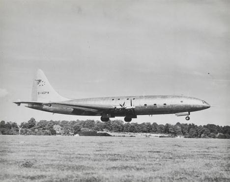
*Bristol Type 167 `Brabazon I`. A group of six P. A. Reuter, Topical Press Agency Ltd, Keystone Press Agency Ltd photographs, recording the first take-off and landing after the first flight of G-AGPU on 4th September 1949, the christening ceremony on 8th October 1947 and the first visit to Heathrow, London`s airport on 15th June 1950, each image approx. 10 x 12in (25.3 x 30.5cm) (6)

*Cattoi, Observer to Natale Palli, Royal Italian Air Force 1915-1917. A rare, perhaps unique, collection of private photographs of this successful team who flew over the Italian /Austrian front during the First World War, flying Ansaldo, Farman, Italian-built Nieuport, Savoia, Cant and Caproni types, some aircraft portraits including Nieuport Ni. 1765, air-to-air of an Ansaldo reconnaissance aircraft, crashed Caproni, an airship shed and image taken at dawn from an airship, various flying boats, airfields, pilots and other air and ground crews, motor transport, troops going to the front, wrecked fortifications, Caproni Ca. 1144 push-pull trimotor and later post-war Savoia aircraft and others of similar interest, including Italian ace Baracca`s flight to Trento 19-6-1921, approx. 80 images contained in a folder (approx. 80)

*Convair 340. A collection of manufacturer`s and airline publicity photographs of this successful post World War Two twin-engined airliner, some fine air-to-air aircraft portraits, ground studies including passengers and crews, first flight celebrations of Lufthansa, Swissair and other airlines, cockpit details, numerous liveries including Allegheny, Delta, Finnair, Frontier, Jugoslovenski, Kar-Air, K.L.M., Mowhawk, National, Sabena, S.A.S., ScanBee, United and others, a good record of period air travel showing a more relaxed approach to passenger handling than that experimenced in 2012, approx. 80 images, many inscribed or labelled verso, contained in a modern ring binder (approx. 80)

*Porro, General Carlo Di Santa Maria. A collection of First World War private photographs of aircraft and Royal Italian Airforce personnel with some inscriptions (now faded), together with views of the airship [?] N-5, some air reconnaissance images including a mosaic of two labelled Cattoi others dated 19-XII-17, air-to-ground views of Castel Franco Venteo, Trieste a military airfield inscribe Campo di Medeurra Agosto 1915 with others of similar interest, contained in an album, the cover inscribed in pencil Porro and a newspaper cutting dated 29.10.1939 and later copy images relating to General Porro (-)

*RAF. An album of photographs compiled by Cyril Browne, mostly c. 1940s/1950s, including 140 corner-mounted photos of aviation interest, mostly reprints copyrighted The Aeroplane, etc., including images of First World War aircraft, RAF of today, Fleet Air Arm, civil aircraft, RAF stations, aerial views and pinpoints, the remainder of the album containing approx. 240 additional corner-mounted photos, including a few of Browne`s time in USA (1942-44), in Aden and Iraq, a 1939 voyage to the Arctic in a trawler, photographs of trains (approx. 100), plus some personal and miscellaneous, various sizes, many neatly captioned and mounted as multiples and back to back throughout, orig. limp cloth, a little rubbed, oblong folio, together with a signed typed copy of Browne`s account of his RAF career to accompany the photo album, 20 pp., typed to rectos only, a little spotting, folio (2)
Bader (Group Captain Sir Douglas, 1910-1982). The Debt We Owe, The Royal Air Force Benevolent Fund 1919-1969, by Edward Bishop, 1st and 2nd revised and enlarged eds., 1969 & 1979, b&w illusts., both presentation copies to Douglas Bader in appreciation of his support of the Fund and the International Air Tattoos, each signed by the controller of the RAF Benevolent Fund, Denis Crowley-Milling, both a.e.g., each contemp. blue morocco gilt (non-matching colour but uniform sizes, raised bands and lettering) by Sangorski & Sutcliffe and Kemp Hall, Oxford, respectively, errata slip to first volume loosely inserted, spine sl. faded, upper cover to second volume sl. bowed, both 8vo, together with Turner (John Frayn), Douglas Bader, A Biography of the Legendary World War II Fighter Pilot, 1st ed., 1995, b&w illusts., signature of Bader`s wife, Joan Bader, to front free endpaper, orig. cloth in d.j., 8vo, plus others mostly RAF related from the Estate of Douglas and Joan Bader, the majority author signed copies, and including three presentation copies to Douglas Bader and eight copies presented to Lady Bader, mostly orig. cloth in d.j.s (17)
Flight. A Journal of Aerial Locomotion and Transport, vols 1 & 2, 1909-1910, unbroken run of issues from no. 1 through to no. 105, b & w photo. illusts and diagrams, lacking title page of first issue and final leaf of last issue, one other leaf detached, a few leaves with edge fraying, contemp. cloth, fraying to extrems with one cover detached, 4to, together with The Aero Manual. A Manual of Mechanically-Propelled Human Flight...Compiled by the Staff of `The Motor`, 1st ed., 1909, b & w half-tone photographs and diagrams, trade adverts front and rear, orig. pictorial cloth, fraying to extrems, 8vo, plus other aviation including volume 28 of Flight (Oct - Dec 1935), two 1930s editions of Interavia ABC, etc. (9)
Flight. The First Aero Weekly in the World, vol. 12 Jan-December 1920; vol. 13 Jan-December 1921; vol. 22 July-December 1930; vol. 23 Jan-December 1931; vol. 24 Jan-December 1932; vol. 25 Jan-December 1933 (bound in 2 vols.); vol. 26 Jan-December 1934; vol. 27 Jan-December 1935 (bound in 2 vols.); vol. 29 Jan-June 1936; vol. 30 July-December 1936 (bound in 2 vols.); vol. 31 Jan-June 1937; vol. 32 July-December 1937, together 15 bound vols., numerous b & w illusts. and ads., mixed cloth bindings (vols. 23 & 24 bound in publisher`s orig. grey cloth lettered in black), together with The Aeroplane. The Most Influential Aviation Journal in the World, vol. 28 Jan-June 1925; vol. 29 July-December 1925; vol. 32 Jan-June 1927; vol. 33 July-December 1927; vol. 37 July-December 1929; vol. 41 July-December 1931; vol. 42 Jan-June 1932; vol. 33 July-December 1932; vol. 45 July-December 1933; vol. 50 (and part 51) May-December 1936; vol. 50 (in orig. parts), Jan-June 1936; vol. 52 Jan-June 1937; vol. 53 June-December 1937; vol. 54 Jan-June 1938; vol. 55 Jan-December 1938; vol. 56 Jan-June 1939; vol. 57 (in orig. parts) July-December 1939, together 15 bound vols. (plus vols. 50 & 57 in orig. parts), numerous b & w illusts. and ads., mixed cloth bindings, some minor wear, 4to (32)
-
596772 item(s)/page