

Carey & Lea, 1823 Geographical, Statistical, and Historical Map of Arkansa Territory / Map of Arkansa and other Territories of the United States For this commercial atlas version of the Stephen Long report map, Carey & Lea chose a single sheet format at a reduced scale with the political boundaries highlighted in color. Extraneous details, including Major Long`s astronomical notations, camp site locations, and elevation profile were eliminated, and information about Arkansas and surrounding territories was added in columns framing the map at the sides. The geological details were retained thus qualifying the map for an affordable alternative to Long`s report-version map. Minor variations in place names, landform engravings and lettering between the atlas and Long`s map exist with the most obvious being ""Great Desert"" substituted from Long`s famous ""Great American Desert"" found on his report map. Other interesting differences exist, such as ""Pawnee villages deserted in 1810"" whereas the Long map uses the date of 1820 on the first edition, thereafter changing to 1810. This second edition Carey & Lea edition also contains minor variations in the surrounding text. Claims are sometimes made that the first edition (1822) Carey & Lea map preceded the publication of the Long report map based on a date of 1823 for the report. However, both were actually published in 1822 making the distinction impossible to tell from date alone. Even Wheat erroneously assigns an 1823 date to the Long report map. An interesting question that deserves further study. The map itself measures 14.5 x 14.5"". Drawn by Stephen Long and engraved by Young & Delleker. 20.6"" W x 16.6"" H Fine, original hand color with light offsetting and toning along centerfold. There is an archivally repaired centerfold separation at bottom that does not enter map.
We found 596780 price guide item(s) matching your search
There are 596780 lots that match your search criteria. Subscribe now to get instant access to the full price guide service.
Click here to subscribe- List
- Grid
-
596780 item(s)/page

Fremont/Preuss, 1845 Map of an Exploring Expedition to the Rocky Mountains in the Year 1842 and to Oregon & North California in the Years 1843-44 [with] Report of The Exploring Expedition to the Rocky Mountains This is the large edition of the influential map which details John Charles Fremont`s epic exploration of the American West. Fremont and his traveling companion and topographer, George Carl Preuss, launched the expedition from the frontier settlement of Westport at the juncture of the Kansas and Missouri Rivers. There Fremont first met Kit Carson who signed on as guide to the expedition. Traveling across the Rocky Mountains at South Pass to the Columbia River in Oregon Territory, they then continued south along the Sierra Nevada nearly to the ""Pueblo del los Angeles"", northeast to Lake Utah and finally east to the Arkansas River. Fremont`s map and report had a profound influence on emigration to the Far West as his westward route eventually became the Oregon Trail. Wheat, who called this ""an important step forward from the earlier western maps"" devoted seven text pages to its description. The map was drawn by Charles Preuss ""whose skill in sketching topography has probably never been surpassed in this country."" There is much to study and appreciate in this rare map, but we return to Wheat for this short praise: ""To Fremont and his magnificent map of his Second Expedition all praise. This is an altogether memorable document in the cartographic history of the West, and for it alone Fremont would deserve to be remembered in history."" 51"" W x 30.5"" H Issued folding with numerous splits at fold intersections and a few resulting in small loss in blank areas of map image. Scattered foxing.
![Johnson & Ward, 1862 [Lot of 2] Johnson`s New Map of the State of Texas [and] Johnson`s California Territories of New Me](http://lot-images.atgmedia.com/SR/36385/2901770/232-201425154028_468x382.jpg)
Johnson & Ward, 1862 [Lot of 2] Johnson`s New Map of the State of Texas [and] Johnson`s California Territories of New Mexico and Utah ""A. Johnson`s New Map of the State of Texas (24.8 x 16.3""""). The first edition of this handsome map, with county development mostly in eastern Texas and only the three large counties of El Paso, Presidio, and Bexar in the west. The panhandle, noted as the Staked Plain (Elevated Table Land, without Wood or Water), includes a large section that is unorganized. There are numerous wagon roads, a few completed railroads, and the US Mail Route traced on the chart. Insets include a Plan of Sabine Lake, Plan of the Northern part of Texas, and Plan of Galveston Bay. Surrounded by Johnson`s early strapwork border. On verso is text from a Historical and Statistical View of North America. Condition: Light offsetting and toning with a few small spots in the image. There are a few edge tears at bottom confined to the bottom blank margin closed on verso with archival tape. B. Johnson`s California Territories of New Mexico and Utah (24.5 16.8""""). This is one of the most desirable editions from this great series of maps covering the Southwest. Arrizona shows up in the southern part of New Mexico Territory. This is thought to represent the Confederate Territory of Arizona that existed for nearly a year from August 1861 until July of 1862. The Confederate General Baylor appointed himself the territorial governor and claimed all of New Mexico Territory south of the 34th parallel. In the southern part of Arizona is the """"Gadsden Ten Million Purchase of Mexico."""" The Utah/Nevada border is too far west on the 116th meridian. Details the Emigrant Road, the Hastings Road, and the routes of numerous explorers and military expeditions. The Gold Region in Colorado`s South Park is prominently shown. The map is filled with historic and interesting notations. One note in the area of Quartzite, Arizona refers to the area as being """"exceedingly fertile and abundantly timbered and well watered."""" Additional details include the U.S. Mail routes, the Emigrant road to California, the proposed railroad route through Utah, Nevada and California, and the Pony Express trail, the last time it appears on this series of map. Johnson was diligent in constantly revising his plates with new information. Condition: Light toning with an edge tear at bottom that extends 2"""" into the image and has been closed on verso with archival tape."" "" W x "" H See descriptions above.

Colton, G.W. & C.B. 1865 Colton`s Map of California, Nevada, Utah, Colorado, Arizona & New Mexico This map of the Southwest features the Pacific Railroad which is shown only partially completed just entering Utah, with the ""proposed route"" extending westward. Arizona Territory encompasses the southern tip of Nevada and has its first four counties, namely Mohave, Yuma, Pima and Yavapai with Prescott as the capitol. New Mexico Territory retains its original `strip` counties. The Utah/Nevada border still extends to 115°, and Wyoming is known as Dakota Territory. The Pony Express route is shown, as is the Mail Route. The map has exceptional information on railroads, both built and planned. It is filled with place names, information on topography and watershed, and numerous notes. For example, one note in west central Colorado states ""Elevated plain, fertile, gently rolling with fresh water, lakes and timber."" Fancy titling and decorative scroll-style border. Dated 1865, but published circa 1869. 26.5"" W x 17.1"" H Original color with a few small spots and light toning along centerfold and sheet edges.

Vandermaelen, Philippe Marie Guillaume 1825 Amer. Sep. Partie de la Nouvle. Californie. No. 52 ""This map features the central California coast from approximately Monterey south to Catalina Island. A chart of elevations fills the bottom of the map. The Atlas Universel contained 400 maps in six volumes. It was the first atlas made up of lithographed maps, and the first to present all the maps on the same scale (1: 1,641,836), with each map covering an area of approximately 20 degrees longitude (from Paris) and 6 degrees of latitude. If all the maps were joined together they would form a globe of 7.75 meters in diameter. The maps were published by subscription between 1825 and 1827, with each part containing ten maps. There was only one edition and the subscription list shows that 810 copies were sold; thus the maps are quite rare."" 19.6"" W x 18.3"" H Original color with scattered foxing.
![U.S. Government, 1847 [Lot of 4] Sketch of the Battle of Los Angeles Upper California... [and] Sketch of the Passage of the](http://lot-images.atgmedia.com/SR/36385/2901770/240-201425154043_468x382.jpg)
U.S. Government, 1847 [Lot of 4] Sketch of the Battle of Los Angeles Upper California... [and] Sketch of the Passage of the Rio San Gabriel... [and] Sketch of the Actions Fought at San Pascal... [and] [Untitled - Map of the California Coast] ""This lot of four government issued maps displays troop positions and actions in Southern California during the Mexican-American war. These maps were published in the Message from the President of the United States to the Two Houses of Congress at the Commencement of the First Session of the Thirtieth Congress in 1847. A. Sketch of the Battle of Los Angeles Upper California, Fought Between the Americans and Mexicans Jany. 9th 1847 (8.4 x 5.8""""). A very early map showing Los Angeles. Locates the Pueblo de Los Angeles, the Rio de Los Angeles, and the moving positions of forces during the battle. B. Sketch of the Passage of the Rio San Gabriel, Upper California, by the Americans, --Discomfiting the Opposing Mex: Forces, Jan: 8th 1847 (8.3 x 6.3""""). Shows the American troops advancing across the Rio San Gabriel and the resulting withdrawal of Mexican forces. C. Sketch of the Actions Fought at San Pascal in Upper California between the Americans and Mexicans Dec. 6th & 7th 1846 (8.0 x 11.2""""). Depicts the battle between Kearny`s troops and those of Mexican Major Andres Pico. Once reinforcements arrived, Kearny was able to push Pico`s troops south and reach San Diego. D. [Untitled - Map of the California Coast] (12.0 x 14.5""""). Covers the California coast from Fort Sacramento south with an inset of lower Baja California. It displays the route of the American militia from Sutter`s Fort to San Diego from mission to mission. There is a key at left that gives the number of men present between different points of the march."" "" W x "" H Issued folding with a few minor spots in the image. The third and fourth map each have binding trims at top, and the third map has one small binding tear closed on verso with archival tape.

1784 Cartes Particulieres des Concessions Faites par l`Angleterre a la France et a lEspagne par la Traite de 1783 ""These four maps represent British possessions that were handed over to Spain and France as a result of the Treaty of Paris. The territories of East and West Florida and Minorca were given to Spain while France gained Tobago and Senegal. The map of Florida is shown with a northern border at 31 degrees latitude, about half a degree farther north than its present border. A huge area along the east coast is shown as swamp, most likely a misplaced Everglades. Each of the maps show only a few place names and basic topography. The map appeared in Nicolas Ponce and Francois Godefroy`s Recueil d`estampes representant les differents evenements de la guerre qui a procure l`independance aux Etats unis de l`Amerique. This was the first French publication to name the United States in its title. On a sheet of French text measuring 8.0 x 9.0""""."" 6.9"" W x 5.1"" H There is a faint damp stain occupying the left portion of the image and an infilled worm track in the bottom left corner of the text beneath the map image.

Matthews-Northrup Co, 1926 Map of the Peninsula of Florida and Adjacent Islands. Florida East Coast Railway This 1926 edition is one of the last examples of this map, which first appeared in the 1890s. It shows the Flagler railroad system from Jacksonville to Miami and Key West, with steamboat connections to Havana. Apart from the panhandle, which does not appear on this map, all the current Florida counties are depicted along with cities, roads, rivers and lakes. Includes an inset at bottom ""Map of Florida and the West Indies."" 15.6"" W x 39.8"" H Issued folding with a few fold separations that have been closed on verso with archival tape. There are a few closed edge tears and small damp stains confined to the blank margins.
![U.S. Government, 1838 [Lot of 2] Map of the Northern Part of the State of Maine and the Adjacent British Provinces
[and] Ex](http://lot-images.atgmedia.com/SR/36385/2901770/266-201425154125_468x382.jpg)
U.S. Government, 1838 [Lot of 2] Map of the Northern Part of the State of Maine and the Adjacent British Provinces [and] Extract from a Map of the British and French Dominions in the North America by Jn O. Mitchell The first map details the boundary dispute between the United States and Great Britain relating to Maine. Hand coloring is used to show the boundary as claimed by the United States and by Great Britain, with a third line labeled ""that of the Arbiter"" which closely corresponds to Maine`s present-day border with Canada. A table gives the major points of contention in this border dispute. Another table names land grants belonging to six land holders. The second map (13.3 x 13"") was included in the same Senate report for historical purposes. It was extracted from Mitchell`s map of 1755 by W.J. Stone. 16.5"" W x 15.3"" H Issued folding with some light stains in the image and binding trims at left.

Smith, Charles 1796 A Plan of the Action at Breeds Hill*, on the 17th of June 1775. Between the American Forces, and the British Troops. *Erroneously Called Bunkers Hill This rare map is a reduced version of Thomas Hyde Page`s plan of the Battle of Bunker Hill. Although the battle resulted in a British victory and loss of control of Boston, the campaign was considered one of the first steps towards American independence. Page served as aide-de-campe to General Howe during the action. His plan was first published by Faden and later in Charles Stedman`s history of the American Revolution. Smith`s edition of the plan, in addition to being publishing in the United States, is important because it correctly identifies Breed`s Hill as the site of the battle. It also changes the title to emphasize the American forces: ""...between the American Forces, and the British Troops"" vs. ""...between His Majesty`s Troops under the Command of Major General Howe, and the Rebel Forces."" The map shows British landing places, lines of attack, movements of the British ships, Warren`s Redoubt, and the deployment of the defending forces. The British troops are shown in red with the American forces depicted in blue. Due to the ephemeral nature of Smith`s Military Repository, this map is rarely found on the market. 8.3"" W x 9.2"" H Overall toning with minor soiling and margins professionally restored with skilled facsimile of the top neatline.

Carey & Lea, 1822 Geographical, Statistical, and Historical Map of Missouri. This is the first published map of Missouri as a state and is surrounded by text describing the boundaries, rivers, climate, chief towns, commerce, education, and religion of the state. The map depicts 15 counties with virtually all settlement concentrated along the Missouri and Mississippi rivers. In the western portion of the state the Osage Boundary Line is shown, in reference to the Treaty of Fort Clark (1808) in which the Osage Nation ceded everything east of this line and north of the Arkansas River to the United States. On a full folio sheet (20.5 x 16.5"") and engraved by Young & Delleker. 9.8"" W x 11.7"" H A nice impression on a clean sheet with light toning along the centerfold.

Anon., 1776 Sketch of the Country Illustrating the Late Engagement in Long Island This is the first edition, published in October 1776, of this map that shows the initial troop positions and battle activity of this important and early American Revolution battle. Troop and battle deployments are clearly shown. A fascinating Revolutionary War map designed to inform the British people about the American cause of independence. 12.4"" W x 7.8"" H Issued folding with faint offsetting and a few misfolds. A binding trim at left has been replaced with old paper.
![U.S. Army, 1866-1900 [Lot of 3] Sketch of Vicinity of Fort Fisher
[and] Plan and Sections of Fort Fisher
[and Untitled Map](http://lot-images.atgmedia.com/SR/36385/2901770/295-201425154215_468x382.jpg)
U.S. Army, 1866-1900 [Lot of 3] Sketch of Vicinity of Fort Fisher [and] Plan and Sections of Fort Fisher [and Untitled Map of Wilmington] ""The first two maps are plates No. 5 and No. 6 from the report and are early published Civil War maps; most reports and maps withheld publication until the 1890`s to allow time for the national wound to heal sufficiently for a public discussion of the conflict. A. Sketch of Vicinity of Fort Fisher Surveyed Under the Direction of Brvt. Brig. Gen. C.B. Comstock Chief Engineer (9.8 x 14.4""""). Provides good detail of the peninsula, locating Ft. Buchanan, Mound Battery, Fort Fisher, headquarters, Wharf, Hospital, the Commissary and Fort Lookout to the north. Also locates the Wreck of the """"Powder Vessel"""" some 830 yards north of Fort Fisher. Condition: Light toning along the folds. B. Plans and Sections of Fort Fisher Carried by Assault by the U.S. Forces Maj. Gen. A.H. Terry Commanding Jan. 15th 1865 (15.3 x 10.6""""). Very close detail of the Fort to show the position of all armament along the fortified walls. Locates cannon (""""rifle"""") locations including the huge Columbia 10"""" cannons at each end with many smaller (4.5"""" to 8"""") cannons positioned between. The map shows Electric Wires leading out from the walls to a Line of Torpedoes protecting the open ground beyond the fort`s wall. It is quite rare to see this type of weapon mentioned on a map. Further research shows electrically triggered land-based torpedoes were used as early as during the Crimean War, 1854-1856. Condition: Light toning along the folds with a few short splits at fold intersections. C. [Untitled Map of Wilmington], circa 1900 (4.8 x 6.7""""). Shows the area from Wilmington south to Cape Fear and the defenses. Condition: Light toning."" "" W x "" H Issued folding. See description above for additional details.
![Columbian Magazine, 1787 Plan of the Remains of Some Ancient Works on the Muskingum [with magazine] The Columbian Magazine,](http://lot-images.atgmedia.com/SR/36385/2901770/298-201425154219_468x382.jpg)
Columbian Magazine, 1787 Plan of the Remains of Some Ancient Works on the Muskingum [with magazine] The Columbian Magazine, or Monthly Miscellany, for May, 1787 This rare issue with the map and accompanying article represent the birth of American Anthropology as they are ""thought to have been the first description and plan of an American earthwork ever published"" (American Anthropologist, Vol 10, p. 343.). About two pages are devoted to an ""Account of Some Remains of Ancient Works, on the Muskingum..."" by Captain Jonathan Heart of the First American Regiment. Heart was commissioned as a Captain by Congress and was ordered to the Muskingum Valley to protect the surveying parties there. It was during his service there that he produced the account and plan of the ancient Indian works located near present-day Marietta, Ohio. As an experienced draughtsman it is likely the plan of the ancient mound works was his. The plan contains a key for circular mounds, walls, caves and graves, and details an area of about one square mile on the east bank of the Muskingum River. The plan is on a scale of 10 chains to an inch (666 feet). The accompanying magazine contains another fold-out plate and extracts of articles by Thomas Jefferson and Benjamin Franklin. 8.6"" W x 7.1"" H Issued folding with scattered foxing and staining along one fold. A few short fold separations have been closed on verso with archival tape and there is a binding trim at lower right. Disbound text is good with scattered foxing and toning.

Anon., 1779 A New and Accurate Map of the Province of South Carolina in North America There is a vast amount of information on this uncommon map of South Carolina including precincts, townships, towns, forts, Indian villages and reservations, roads and trails, ferries, courthouses, landmarks, swamps, rivers, creeks, harbors, islands and shoals. The border with North Carolina is marked both Boundary in 1772 and Old Boundary Line. Even though the Board of Trade in London order the first survey of the boundary line in 1730, the royal governors of the two colonies took seven years to choose the surveyors - none of whom had any surveying experience. The men were directed to follow a northwestern course, from an agreed-upon point on the coast, until they reached the 35th parallel and then to go due west. After months of battling swamps and other hardships the surveyors quit 11 miles south of the 35th parallel. In 1764, after the Catawba Indians 15-miles-square reservation was agreed upon in the Treaty of Augusta, another surveying party was ordered to pick up where the earlier group had stopped. Instead of taking the boundary line 11 miles to the north, as originally instructed, the second party went due west for 62 miles before stopping at a place now known as Old North Corner. It was not until 1772 that commissioners and surveyors from both colonies were appointed to run a revised line, which in fact just carried on in a northwestern course from the Old North Corner to a point about 11 miles north of the 35th parallel (in order to make adjustment for the previous error that resulted in a loss of territory for South Carolina). The line then proceeded west and ended at the Cherokee Line. 11"" W x 13.3"" H Issued folding on watermarked paper with light off-setting, a minor printer`s crease at top, and a tiny hole near center. There is a binding trim at bottom left that does not affect map.
![Bowen & Co., John T. 1860 [Lot of 2] Map of Charleston Harbor S.C. [and] Chart of the Eastern Extremity of Fort Reef, Ch](http://lot-images.atgmedia.com/SR/36385/2901770/313-201425154247_468x382.jpg)
Bowen & Co., John T. 1860 [Lot of 2] Map of Charleston Harbor S.C. [and] Chart of the Eastern Extremity of Fort Reef, Charleston Harbor, S.C. Exhibiting the Location of Fort Sumter... [on sheet with] Plan and Sections Presenting a General View ... Fort Sumter ""A. Map of Charleston Harbor S.C., hand color (22.6 x 17.6""""). This uncommon chart shows the approaches to Charleston. It was first published in 1835 and republished in the American State Papers. Using a scale of 4 inches = 1 mile, it served as the basis for subsequent maps of the Coast Survey. A key in the lower left says """"The curves drawn in red represent lines on the bottom of the harbor at the depths of 6, 12, 18, and 24 feet below mean low water. The part of the Harbor where the water is 18 feet deep is colored with India ink. The surface always covered with water is colored blue. The surface between high and low water marks is colored with bistre."""" Shows drainage, vegetation, cultivated areas, swampland, roads. The forts are prominently featured, and nine inch circles delineate the range of their guns. Fort Sumter, with smaller guns, uses six inch lines to show their range. Condition: A nice example, issued folding, with light toning at top, minor offsetting, and one tiny split at a fold intersection. Binding trim at lower left. B. Chart of the Eastern Extremity of Fort Reef, Charleston Harbor, S.C. Exhibiting the Location of Fort Sumter... [on sheet with] Plan and Sections Presenting a General View of the Actual Condition of the Foundations of Fort Sumter, black and white (24.0 x 10.5""""). This chart accompanies the map above and shows the position and foundation of Fort Sumter. Condition: Issued folding with light offsetting and a fold separation that extends 1.5"""" into the image repaired on verso with archival tape."" "" W x "" H See descriptions above.

Mitchell, Samuel Augustus 1846 No. 13 Map of the State of Texas This map features the ""Stovepipe"" configuration showing Texas at its largest extent when first admitted to the Union. It shows the western boundary at the Rio Grande del Norte, putting Santa Fe in Texas. Part of Texas continues to the northwest above Taos in an area labeled the Green Mountains. This edition is the first to name Dallas. There are no counties formed west of about 98°, but there is a large unorganized Bexar region above San Antonio de Bexar and below a region labeled Wild Horses. In the western region a number of Indian tribes are named. This is the most desirable map of Texas from the Mitchell school geographies. 8"" W x 10.5"" H A little marginal toning and foxing with some just entering map at left, else very good.
![U.S. Coast Survey, 1848-49 [Lot of 2] The Report of the Superintendent of the Coast Survey, Showing the Progress of That Wor](http://lot-images.atgmedia.com/SR/36385/2901770/318-201425154255_468x382.jpg)
U.S. Coast Survey, 1848-49 [Lot of 2] The Report of the Superintendent of the Coast Survey, Showing the Progress of That Work ""This lot includes the 1848 (HR Ex Doc No. 13, 30th Congress, 2nd Session) and 1849 (HR Ex Doc No. 14, 31st Congress, 1st Session) government reports describing the survey of the Texas coast that began in 1848 under the direction of A.D. Bache, Superintendent U.S. Coast Survey. Each includes the first published chart of the survey of the Texas coast """"Sketch G Showing the progress in Section No. 9,"""" centered on Galveston City and extending to include the West and East bays and north to Edward`s Point. The end of the Mexican War and settlement in the northwest with Great Britain nearly doubled the coastline of the U.S. under the Coast Survey`s charge. Surveying work began at Galveston Bay with triangulations laid out in every direction and key points determined from Galveston Bay to the mouth of the Brazos River. In addition to the two Galveston maps, there are 30 other charts and plates featuring Cape Cod, Nantucket, Boston Bay, Sandy Hook, Chesapeake Bay, Long Island, the Outer Banks area of North Carolina, and Charleston to name a few. 1848 edition - 120 pp.; 1849 edition -- 98 pp. Disbound. 8vo."" 6"" W x 9"" H 1848 edition: contents are clean and bright, with many of the charts having never been opened before. 1849 edition: contents have scattered foxing with several of the maps appearing to have never been opened before.
![1916-22 [Lot of 8] Wyoming Road Map [and] Naval Reserve Oil Leases [and] Oil and Gas Fields of the State of Wyoming [and] Lo](http://lot-images.atgmedia.com/SR/36385/2901770/331-201425154319_468x382.jpg)
1916-22 [Lot of 8] Wyoming Road Map [and] Naval Reserve Oil Leases [and] Oil and Gas Fields of the State of Wyoming [and] Location of Wyoming Oil Fields [and] Pilot Butte Oil Field [and] Oregon Basin Oil Fields [and] Rock Creek Oil Field [and] Mahoney... ""This is a fascinating lot focused on the oil producing regions in Wyoming. The state enjoyed tremendous economic and population growth in the early 20th century fueled by its mineral resources. One of the most notable events that occurred during this boom was the infamous Teapot Dome scandal in which Secretary of the Interior Albert B. Fall leased Navy petroleum reserves to private oil companies at low rates in return for kickbacks. Fall was later convicted of accepting bribes from the oil companies, and was the first member of a Presidents cabinet to go to prison for his actions while in office. The Teapot Dome, and numerous other oil fields in the region, are the focus of the maps in this group including: A. Wyoming Road Map, by The Casper Independent, circa 1920, black and white (17.8 x 9.8""""). Rare promotional map for Hotel Henning focused on the road network in the state, including """"all weather roads"""" and """"roads requiring chains in wet weather."""" More interesting, however, is the identification of 11 oil fields including the Teapot Dome Oil Field close to Casper. Folds into a brochure with various advertisements on verso (4 x 9.3""""). Condition: (A) B. Naval Reserve Oil Leases, by U.S. Government, Doc. 210, 2nd Session, 67 Congress, published 1922, printed color (5.9 x 9.1""""). This is Falls` 44 pp. report to the President on the leasing of oil reserves known as the Teapot Dome scandal. Includes two maps in the report, Structural Map of Salt Creek Region Wyoming showing the boundaries of the Salt Creek field and Teapot Dome, and Map of the Salt Creek Oil Field, Including the Shannon Pool and Teapot Dome, Natrona County, Wyo. Condition: Maps are clean and bright with each having a short edge tear confined to the blank margin. Report is generally good with corners slightly dog-eared. (A) C. Oil and Gas Fields of the State of Wyoming, by U.S. Geological Survey, circa 1922, black and white (18.9 x 15.1""""). Very detailed map showing oil and gas fields including those that are producing. Oil refineries are also identified. Published by G.B. Morgan, State Geologist. Condition: Issued folding on a clean sheet with faint toning along the folds and a previous owner`s stamp on verso. (A) D. Location of Wyoming Oil Fields, Anonymous, circa 1919, black and white (7.4 x 5.6""""). Small map showing the oil fields, pipelines and refineries in the state. The railroad network is also depicted. Condition: Watermarked paper with just a hint of toning along the centerfold. (A) E. Pilot Butte Oil Field, by Victor Ziegler, dated 1916, printed color (21.3 x 27.3""""). This map has good detail of the oil wells in the area and notes sandstone and shale formations. Contour lines are also depicted. Condition: Issued folding with one small edge tear closed on verso with archival tape. (A) F. Oregon Basin Oil Fields, by Victor Ziegler, dated 1917, printed color (11.9 x 15.8""""). Similar but smaller map to above (E) showing the oil wells and geological features of the region. Condition: Issued folding. (A) G. Rock Creek Oil Field, by G.B. Morgan, from Press Bulletin Number 7, dated 1920, black and white (6.5 x 11.5""""). This is a copy of a manuscript map showing the oil wells in the region including producing wells, incomplete wells and abandoned wells. A note in the right margin shows that the daily production of this oil field is 5,700 barrels. The map is accompanied by a 5 page note describing the oil field. Condition: The lower third of the map has been fully separated and reattached with archival tape on verso. Light toning. (C+) H. Mahoney and Forest Fields, by G.B. Morgan, from Press Bulletin Number 7, published 1922, black and white (6.8 x 12.0""""). Another copy of a manuscript map showing the oil and gas wells in the region, noting those that are unfinished or abandoned. Condition: The lower third of the map has been fully separated and reattached with archival tape on verso with several wormholes in the image. Light toning. (C+) "" "" W x "" H See descriptions above.

SDUK Society for the Diffusion of Useful Knowledge, 1849 Central America II. Including Texas, California and the Northern States of Mexico... This excellent map covers the southwestern United States subsequent to Mexico losing the region in the Mexican/American War. Texas is shown at its largest extent with the panhandle extending well north up to Spanish Peaks. All of the Southwest and California are here noted as ""Nueva or Upper California."" Charles Fremonts first expedition up the Oregon Trail and through the Sierra Nevada is traced and there are several notations in the Great Interior Basin of California from that important exploration. Lake Tahoe makes an early appearance as Mountain L. The Great Spanish Track from Pueblo de los Angelos to Santa Fe is also noted. There is great detail throughout including forts, Indian tribes, and numerous interesting notations. This is an updated version of the map first issued in 1842; engraved by J. & C. Walker and published by Charles Knight. 15.8"" W x 12.3"" H There is a hint of toning and one short edge tear just entering the neatline at left that has been closed on verso with archival tape.
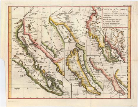
Robert de Vaugondy, Didier 1772 Carte de la Californie Suivant I. la Carte Manuscrite de l`Amerique de Mathieu Neron Pecci... This sheet has five depictions of California that present a fascinating cartographic history of the region. It was one of ten maps compiled by Robert de Vaugondy for Diderot`s important encyclopedia and depicts the mapping of California by five important cartographers. The earliest map reproduces Neron Pecci`s manuscript map of 1604 showing the peninsula with a ragged coastline and place names derived from Cabrillo`s voyage of 1542-3. The second map is a detail from Sanson`s 1656 map showing the island of California with place names from the voyage of Vizcaino. Map three is from Delisle`s map of America of 1700 with the question of California`s insularity left open to interpretation. Next is Fra. Eusebio Kino`s important map of 1705 that finally ended that cartographic myth. It is based on his overland expedition from the mainland to the Sea of Cortez. Finally, map five is a portion of a Spanish map, showing the Jesuit explorations, that first appeared in Miguel Venegas` Noticia de la California in 1757, which is the first published history of California. This is an essential map for any California map collection. 15.3"" W x 11.5"" H Nice impression on a clean sheet with minor printer`s ink residue and a binding trim at lower left.

Hardy, Lieut. R.W.H Hardy 1829 Travels in the Interior of Mexico, in 1825, 1826, 1827, & 1828 ""This first edition is a vivid and early portrayal of the culture and geography of northwestern Mexico based on the author`s extensive travels in the region. Hardy was in search of pearls in the Gulf of California. The result of his journey is a fascinating book and map on """"the little known regions of Senora and Lower California"""", (Map of Sonora and Gulf of California, 17 x 13""""). This scarce map extends from the Gila River in the north to Mexico City. Most of the eastern portion is blank and shows only western towns, including S. Juan del Rio, Guanaxuato, Guadalaxara, Durango, Chihuahua and much of the Rio Grande River. Curiously, the town """"Arizona"""" is shown south of the Gila River in today`s New Mexico. Scores of villages are named in the northwest. All of Baja is included with only a few towns -- La Paz, Loreto and Mulege. Legend locates Hardy`s route, Ranchos, Gold and Silver Spots, Real di Minas, Mines, Presidio, and Missions. A second map, Plan of the Rio Colorado, by Lieut. R.W.H. Hardy (7.5 x 4.5"""") is the first American exploration and mapping of the Colorado River from its mouth in the Gulf of California to its confluence with the Gila River. A note claims the high water changes by 22 feet. The six called for plates are present and include: The Game of Monte, in the Streets of Mexico; A Pilgrimage Performed in Mexico; A Mexican Cavallero; Morning Salutations in Mexico; Water Carrier in Mexico; and An Evangelista, or Letter-Writer in the Haza Grande of Mexico. Most descriptions list seven plates, but here we count as a map the Colorado River plate. The book is hardbound in green cloth with gilt title on spine. This first edition is complete, 540 pp, two maps and six plates. Published by Henry Colburn and Richard Bentley, London, 1829."" 6"" W x 9"" H The map has light offsetting, a 1"" binding tear, and a small puncture in a blank area of the map near the center. Contents are clean and tight in near fine condition and the spine is lightly sunned. Library stamp on title page and pastedown on inside fr

Delisle/Covens & Mortier, 1730 Carte de l`Isle de Saint Domingue Dressee en 1722 pour l`Usage du Roy sur les Memoires de Mr. Frezier This is an important map of Hispaniola and the Turks & Caicos Islands. When initially published in 1722 by Delisle it was one of the first to depict the island`s true contours following Frezier`s important map of the island. The chart provides excellent detail of the three districts showing mountains, roads, towns, ports, plantations, sugar works and navigational hazards. Decorated with a large title cartouche and compass rose. Latin title above, ""Insulae S. Dominicae Tabula Accuratissima."" 24.1"" W x 18.6"" H Original color with a hint of toning along sheet edges.

Dudley, Robert (Sir) 1661 Carta Particolare del` Peru che Comincia con il Capo di Guanapo e Finisce con il` C. S. Francesco ""An elegant sea chart of the coastline of Ecuador and northern Peru, extending just south of Trujillo. Numerous place names are shown along the coast, as well as anchorages, soundings, and shoals. The equator is featured prominently towards the top of the chart, and Quito is depicted inland. The chart is embellished with Dudley`s trademark calligraphic style, a strapwork title cartouche, a large compass rose, and a sailing ship. This is the second edition with Lo. 6. added to the title cartouche. Printed on two sheets, joined as issued. Robert Dudley was the first Englishman to produce a sea atlas, Dell Arcano del Mare (Secrets of the Sea). A skilled mathematician and navigator, Dudley was exiled from England and settled in Florence where his atlas was published. He introduced a totally new style for sea charts in the atlas with only lines of latitude and longitude and no rhumb lines. The charts were meticulously compiled from original sources and were both scientific and accurate for the time. This important atlas was the first sea atlas of the whole world; the first to use Mercator`s projection throughout; the earliest to show the prevailing winds, currents and magnetic deviation; and the first to expound the advantages of Great Circle Sailing. In an introductory leaf found in one copy in the British Library, the engraver states that he worked on the plates in seclusion for twelve years in an obscure Tuscan village, using no less than 5,000 pounds of copper for the printing plates. It was only issued in two editions and the maps are rarely seen on the market."" 28.8"" W x 18.3"" H A fine impression on watermarked paper with very good margins. There is light soiling, primarily along the joint, and some small cracks along the joint that have been archivally repaired. A small hole near the coastline at bottom has been professionally
![1806-41 [Lot of 3] Viceroyalty of Peru [and] Charte der Provinz oder Audiencia von Lima oder des Alten Konigreichs Peru [and](http://lot-images.atgmedia.com/SR/36385/2901770/418-201425154559_468x382.jpg)
1806-41 [Lot of 3] Viceroyalty of Peru [and] Charte der Provinz oder Audiencia von Lima oder des Alten Konigreichs Peru [and] Perou et Bolivie ""This lot of 3 maps illustrates the fascinating political changes that took place in Peru during the first half of the 19th century. A. Viceroyalty of Peru, by Cadell & Davies, dated 1806, hand color (8.1 x 9.9""""). This topographical map depicts Peru extending from Tumbes in the north to past Iquique in the south, well into present-day Chile. Lake Titicaca falls entirely outside of Peru, in the Viceroyalty of La Plata; however the eastern border of Peru encompasses portions of Brazil and Bolivia. Mountains are shown by hachures and rivers are well delineated. Engraved by Lowry. Condition: Watermarked paper with light soiling and one tiny hole in image. B. Charte der Provinz oder Audiencia von Lima oder des Alten Konigreichs Peru, by Weimar Geographisches Institut, dated 1820, hand color (11.5 x 16.3""""). This map was published just 4 years before Peru gained its independence from Spain, and again shows Peru extending from Tumbes in the north to past Iquique in the south, however the Viceroyalty only encompasses a narrow strip along the coast. The majority of the region surrounding the Maranon River is labeled Land der Missionen oder der Amazonen. The map is filled with information on the river systems, mountains, towns, and political boundaries. Condition: Original color on watermarked paper. Issued folding with light offsetting and a few small spots. There is a binding trim at bottom left, but still ample room for framing. C. Perou et Bolivie, by Frederic Lacroix, from L`Univers Pittoresque Histoire et Description de tous les Peuples, de Leurs Religions, Moeurs Coutumes, etc., dated 1841, black & white (9.0 x 6.9""""). Peru, now an independent country, still extends south into present day Chile, and now also encompasses a portion of Lake Titicaca. However Bolivia extends west almost to Cusco. The northeastern portion of Peru is labeled Pays Inconnus (land unknown). There is good detail of the rivers and mountains, with a few place names primarily near the coast. Engraved by Jenotte. Condition: Issued folding with a few tiny spots."" "" W x "" H See descriptions above.

Thornton, Samuel 1706 A New Mapp of Magellan Straights Discovered by Cap. John Narbrough (Comander Then of His Majesties Ship the Sweepstakes) as He Sayled Through the Sade Straights ""In 1670, John Narborough was the first Englishman to sail through the Strait of Magellan in both directions; thus demonstrating the falsity of the accepted wisdom that the wind and currents would prevent any eastward passage of the strait. He had been commissioned by James, Duke of York (later James II), to sail to South America to investigate potential trade possibilities. Narborough`s expedition proved that a profitable trade with South America was possible, and this set the course of Britain`s foreign policy for the next half century. Narborough published his journal of the voyage in An Account of Several Late Voyages in 1694. His description of the Strait of Magellan provided the basis for British charts of the strait until the time of Captain Cook. This map is closely based on the map from Narborough`s book, and provides a detailed view of the tortuous course of the strait with soundings and safe anchorages carefully noted. There are several notations along the coasts describing the countryside. A large inset map shows Patagonia and Tierra del Fuego. This re-issue was first published by John Thornton with the addition of numerous embellishments, including the English royal coat of arms of Charles II, a European soldier, Native Americans, ships, animals such as a rhea and guanaco, and a native American dwelling. Samuel Thornton, John Thornton`s brother, took over John`s business in 1706, and then re-published the map with his own imprint, as seen here. Both the original Narborough map and the Thornton re-issues are extremely scarce. We have only found one record of either states of the Thornton map being on the market in the past 25 years."" 20.8"" W x 16.6"" H Wide, original margins with a hint of toning along centerfold. A very nice, clean example.

Blaeu, Willem 1643 Europa Recens Descripta This classic map of Europe is presented in the carte-de-figures style with vignettes on three sides. The upper frieze has nine bird`s-eye views of Amsterdam, Prague, Constantinople, Venice, Rome, Paris, London, Toledo and Lisbon. The side borders contain the costumes of the noblemen and women of ten European nations. The map is embellished with sailing ships, sea monsters, bears, and Neptune riding a dolphin and holding his trident. A beautiful map produced at the height of the Golden Age of Dutch mapmaking; it was included in the first volume of Blaeu`s magnificent atlas. French text on verso. 21.9"" W x 16.2"" H Old color with moderate toning, a centerfold separation entering 0.75"" into neatline at top that has been closed on verso with archival materials, and a few small abrasions. There is also an edge tear entering about 0.5"" into image at top as well as a cr

Ptolemy/Mercator, 1730 Tab. I. Europae, Continens Albion, Britanniam, et Hiberniam... This fine Ptolemaic map of the British Isles shows ancient place names and divisions. Scotland is presented with its distinctive east-west orientation. The map is decorated with a strapwork title cartouche, a sea monster and a fishing scene in the North Sea. Mercator originally published this map in his 1578 edition of Ptolemy`s great Geography; this is from the last edition and a crack in the plate at top is evident in this example. Although he is most renowned today for the projection he popularized and for first using the term `atlas` for a collection of maps, he devoted much of his life to his Ptolemaic maps. The maps were beautifully engraved as nearly as possible to their original form and decorated with strapwork cartouches and interesting vignettes reflecting the customs of the region. 15.6"" W x 13"" H Nice impression and color on watermarked paper. What appears in the image to be centerfold toning is simply show-through of the backstrap.

Robert de Vaugondy, Gilles 1754 Les Isles Britanniques qui comprennent les Royaumes d`Angleterre, d`Ecosse et d`Irlande This finely engraved map of the British Isles is filled with a plethora of place names. A large inset details the Shetland, Orkney and Faroe Islands. The decorative title cartouche incorporates trade goods, military flags and canon, and the royal coat of arms. This is the first state with no islands to the west of Ireland. The cartouche was engraved by one of the talented Haussard sisters. It was published in 1757 as part of the first edition. 23.2"" W x 18.9"" H On watermarked paper with light soiling, a few extraneous creases adjacent to the centerfold, and a printer`s crease at lower right. In bottom blank margin are a faint damp stain and a tear that has been repaired on verso with old paper.

Delisle/Buache, 1772 Les Isles Britanniques ou sont le Rme. d`Angleterre Tire de Sped Celuy d`Ecosse... This is Buache`s reissue of Delisle`s influential map of the British Isles that was first published in 1702. It is based on the foremost authorities: Speed for England and Wales, Pont for Scotland, and Petty for Ireland. The bottom right shows the coasts of the Netherlands, Belgium, and northern France and at the upper right is the southern tip of Norway. The important fishing banks in the North Sea are prominently illustrated and De Kimmen ou le Borneur traces what is now known to the edge of the European continental shelf. The note at lower left explains that Delisle doubts the existence of the islands of Brasil and Assmanda, which appeared on earlier maps. The large title cartouche incorporates mermen, fishing nets, sea birds and sea monsters and is surmounted by Neptune. Another decorative cartouche contains five distance scales flanked by hunting dogs. This is the seventh state, issued just before Buache`s death. 24.1"" W x 18.5"" H On watermarked paper with printer`s ink residue concentrated at the top of the centerfold.

Stow, John 1720 Shoreditch, Norton Folgate, and Crepplegate Without, Taken from ye Last Survey with Corrections A handsome bird`s-eye plan of the area between Liverpool Station, Old Street and Goswell Road, reaching east to Shoreditch High Street and Norton Folgate. Several tables surrounding the map identify streets, yards, squares, churches and public buildings. The boundary between the parishes of St. Leonard Shoreditch and St Giles Cripple Gate is marked with a dotted line. Hoxton Square, which was laid out in 1683 and is believed to be one of the oldest squares in London, is shown to the right of the title cartouche. John Stow`s Survey of London was first published in 1598, and was updated by John Strype with new plans and republished in 1720 and 1755. 13.8"" W x 11.1"" H Issued folding, now pressed on watermarked paper with light soiling and several minor misfolds.

Morden, Robert 1695 Norfolk ""This map of Norfolk is an early county map to show the local roads. The county is divided into """"Hundreds"""" (sometimes abbreviated as Hund on the map), an old English term for an area that would support a hundred families. It locates towns, buildings, forests, rivers, bridges and parks, which are noted by fenced areas. There is a decorative cartouche and three different distance scales. Sold by Abel Swale, Awnsham & John Churchil. Engraved by John Sturt. Morden was one of the first English cartographers to show longitudes measured from the meridian of St. Paul`s Cathedral (shown in degrees at the bottom of the map) and time in minutes measure locally from the sun (shown at the top). The roads on his maps are based on Ogilby`s earlier survey. The Britannia was first published by historian William Camden (1551-1623) in 1586. After the publication of the final edition of Britannia in 1637, the work was not published again until 1695 when Gibson revised and translated the text from the original Latin and included fifty maps, mostly of the English counties, prepared by Robert Morden, replacing the outdated maps of Christopher Saxton."" 23"" W x 14.7"" H A clean, bright example with a tiny tear entering the top border that has been professionally repaired. Issued folding, now pressed and partially trimmed to neatlines at left, top and right.
![1720 [Lot of 18 - English Strip Road Maps] ""This large lot of strip road maps are based upon the surveys containe](http://lot-images.atgmedia.com/SR/36385/2901770/472-201425154749_468x382.jpg)
1720 [Lot of 18 - English Strip Road Maps] ""This large lot of strip road maps are based upon the surveys contained in John Ogilby`s Brittania, first published in 1675. This edition is slightly reduced, but larger than the editions by Thomas Gardner (1719), John Senex (1720), and Bowen & Owen (1720), which were more conducive for the traveler. Each of the sheets contain plate numbers at top right with the following titles: A. Survey of the Roads from London to Bath and Wells...[on sheet with] from Ferrybridge to Boroughbridge... B. A Survey of the Road from London to Boston...[on sheet with]...London to Burton... C. A Survey of the Road from London to Flamborough Head... D. A Survey of the Road from London to Lynn-Regis...[on sheet with]...London to Montgomery...[on sheet with]...London to St. Neots... E. The Road from London to Bristol... F. The Road from London to the 145th Mile-stone in the way to Berwick G. The Continuation of the Road from London to the Lands End...[on sheet with] Plymouth to Dartmouth...[on sheet with] London to New Haven H. The Continuation of the Road from London to Holy Head [on sheet with] The Road from London to Northampton I. The Road from London to Barnstable [on sheet with] Barnstable to the 73 Mile Stone in the Way to Truro J. A Survey of the Road from London to Norwich [on sheet with] London to Okeham K. A Survey of the Road from London to Richmond [on sheet with] London to Alresford L. The Continuation of the Road from London to Southampton [on sheet with] London to Pool [on sheet with] London to Shrewsbury M. Continuation of the Road from Shrewsbury to Welshpool...[on sheet with] London to Wells...[on sheet with] London to Weymouth N. A Survey of the Roads from Chelmsford in Essex to St. Ed. Bury...[on sheet with] Chelmsford to Malden and Raleigh O. A Survey of the Road from Chester to Cardif...[on sheet with] Dartmouth to Minehead P. A Survey of the Road from St. Davids to Holywell Q. A Survey of the Road from Exeter to Barnstable...[on sheet with] Exeter to Dorchester...[on sheet with] Glocester to Coventry...[on sheet with] Glocester to Hereford R. A Survey of the Road from WelshPool to Carnarvan...[on sheet with] Whitby to Durham... Size varies slightly. Images representative of lot."" 14.2"" W x 11.9"" H Issued folding on watermarked paper and now flattened with several short fold separations and binding tears that have been repaired on verso with archival tape and old paper. The maps have light offsetting, occasional toning along the folds, and a few sc

Mercator/Jansson, 1638 Hiberniae Pars Australis This is the southern sheet of Mercator`s two-sheet map of Ireland compiled from his landmark map of Britain (1564). It is one of five Irish maps Mercator designed for the second part of his Atlas. The map is richly engraved with strong topographical features in the interior. The sheet contains a large strapwork title cartouche and has full borders. The map was first published by Mercator in 1595, and was reissued by Jansson with the stippling removed and the title cartouche re-engraved. Latin text on verso. 18.4"" W x 13.4"" H A nice impression with attractive color, wide margins, and a printer`s crease in left blank margin. There is minor show-through of text on verso, a few small spots of foxing, and an archivally repaired centerfold separation that enters 2"" into map at bot

Blaeu, Johannes 1662 Magnus Ducatus Finlandiae Auct. Andrea Buraeo Sueco This superb map was the first separately printed map of Finland, and was also found in several editions of Blaeu`s Atlas Maior and in a few composite atlases. The map is attributed to Anders Bure (1571-1646), a Swedish cartographer and mathematician. Bure, also known as Andreas Bureus, is best known for his 6-sheet map of Scandinavia and for serving as the first director of the Swedish land survey. The map shows the numerous lakes, rivers, and waterways in Finland, which was a Grand Duchy of the Swedish Empire at the time of publication. The title cartouche is adorned with the coats of arms of the various regions in Finland, held aloft by two putti. The map is dedicated to Gustav Horn, a Swedish/Finnish politician and military commander who was appointed Field Marshall by the King of Sweden at the outset of the Thirty Years War. No text on verso, indicating that this example was likely bound in a composite atlas. 20.6"" W x 17.1"" H Nice impression and color with just a hint of toning along centerfold.

Mercator/Hondius, 1607 Leodiensis Dioec. Splendid small map of the Meuse River valley, centered roughly on Liege with east oriented at the top of map. Adorned with a strapwork title cartouche that incorporates the distance scale. This is from the first edition, with Latin text on verso. 7.6"" W x 5.1"" H Watermarked paper with light foxing in blank margins. Cardinal directions and page number written in manuscript ink in blank margins.

Mercator/Hondius, 1607 Wesphalia cum Dioecesi Bremensi This small map centers roughly on Bremen and shows the waterways of northern Germany in careful detail. The map reaches from Emden in the west to the Elbe River in the east. It is adorned with a small ship and a strapwork title cartouche that incorporates the scale of miles. This is from the first edition, with Latin text on verso. 7.4"" W x 5.5"" H A nice impression with one small spot in image at top right. Cardinal directions and page number written in manuscript ink in blank margins.

Mercator/Hondius, 1607 Saxonia Inferior et Mekleburg Lower Saxony and Mecklenburg are the central theme of this appealing map. It covers from Lubeck and the Baltic Sea in the north to Celle, Rathenow and Spandau in the south. Adorned with a strapwork title cartouche that incorporates the distance scale. This is from the first edition, with Latin text on verso. 7.7"" W x 5.5"" H A nice impression with very light soiling. Cardinal directions and page number written in manuscript ink in blank margins.

Ptolemy/Mercator, 1730 Tab. VIII. Europae, in qua Sarmatia, Maeotis Palus, ac Germaniae, Daciaeq. Pars... A crisply engraved Ptolemaic map covering the region from the Vistula River eastward, includes the Sea of Azov and the Baltic Sea. Engraved with rope-like mountains, ancient place names and a nomadic group pictured in the Asiatic part of Sarmatia (present-day Russia). Mercator originally published this map in his 1578 edition of Ptolemy`s great Geography; this is from the last edition and two cracks in the plate at top and center are evident in this example. Although he is most renowned today for the projection he popularized and for first using the term Atlas for a collection of maps, he devoted much of his life to his Ptolemaic maps. The maps were beautifully engraved as nearly as possible to their original form and embellished with fine cartouches. 16.6"" W x 13.3"" H Nice impression and color on watermarked paper.

Homann Heirs, 1773 Mappa Geographica Regni Poloniae ex Novissimis quot quot sunt Mappis Specialibus Composita et ad LL. Stereographica Projectionis Revocata a Tob. Mayero This map of the Polish-Lithuanian Commonwealth was published just one year after the First Partition of Poland. A note below the map indicates that areas marked in ""violet"" were seized by the ""three neighboring powers"" in 1772. After the reign of Augustus III (1696-1763) weakened the Commonwealth, the Russian Empire, the Kingdom of Prussia and Habsburg Austria decided upon partitions of the Commonwealth, and simultaneously sent troops to occupy the newly annexed territories. The Commonwealth was unable to protect the occupied provinces, and ultimately lost 30% of its overall territory in the partition. The title cartouche attributes the map to Johann Tobias Mayer, whose detailed map of the Polish Empire was based on Barnikel`s map of Curland (1747) and Jan Nieprzecki`s map of Lithuania (1749). Poland extends along the Baltic coastline from Riga to Gdansk and stretches southeast to include much of present-day Romania and Ukraine. Topographical information is very good and there is a wealth of information on towns, rivers, lakes, forests and political divisions. French title is outside top border: Carte des Etats de la Couronne de Pologne, Nouvellement dessinee par Mr. Tob. Mayer... 20.1"" W x 17.3"" H Watermarked paper with original color that has been partially refreshed. There is light toning and some printer`s ink residue.

Ptolemy/Mercator, 1730 Tab. X. Europae, Macedoniam, Epirum ac Peloponnesum Repraesentans... A beautiful map of the Balkan Peninsula, Greece, Crete and the Aegean islands. Mercator originally published this map in his 1578 edition of Ptolemy`s great Geography. Although he is most renowned today for the projection he popularized and for first using the term Atlas for a collection of maps, he devoted much of his life to his Ptolemaic maps. The maps were beautifully engraved as nearly as possible to their original form and embellished with fine cartouches. This cartouche shows frolicking mer-people. 17.6"" W x 13.4"" H Nice impression and color on watermarked paper.

Hondius/Bertius, 1618 Ischia Insula A nicely engraved copper plate map of this Italian island at the edge of the Gulf of Naples. The map is oriented with north to the bottom, and towns are depicted as tiny castles. The Romans were the first to discover the healing effects of the island`s hot springs, which are still in use today. Adorned with a decorative strapwork cartouche. French text on verso. 5.2"" W x 3.8"" H A fine impression on watermarked paper with one faint stain in image and minor show-through of text on verso.

Kircher, Athanasius 1682 Typus Montis Vesuvii... Very unusual view with a cut-away to reveal the interior of Mount Vesuvius erupting with smoke and flames billowing forth. A small village named Portici is shown in the foreground. This is from Kircher`s masterpiece, an immense and amazing work covering all aspects of anything that dwelled or occurred within the earth`s interior - from dragons, to fossils, to mountain springs, earthquakes, and volcanoes. Kircher`s work was the first serious effort to describe the physical makeup of the earth, proposing theories (sometimes fantastic) in the areas of physics, geography, geology, and chemistry. It was, in part, based on Kircher`s observations of the eruption of Vesuvius and the two weeks of earthquakes that shook Calabria in 1638. He suggested the existence of a vast network of underground springs and reservoirs, as well as the theory that subterranean temperatures increase directly in proportion to depth. Published in a Dutch edition of Kircher`s famous Subterranean World by Johann Waesberger. 16.1"" W x 14.2"" H A nice impression with attractive color, minor soiling, one tiny hole in the image, and a soft crease at bottom left.

Savry, Jacob 1648 Geographische Beschryvinge, van de Wandeling der Apostelen ende de Reysen Pauli This map portrays the Eastern Mediterranean from Rome, through Asia Minor and the Holy Land, to Babylon. Territorial divisions reflect the political conditions of the first century A.D. The route of Apostle Paul is charted from Jerusalem to Rome. The decorative panels at top and bottom show the major events of Paul`s journey; each vignette being a composite of two or three episodes. The one at the left of the cartouche shows Paul`s baptism by Ananias and his daring escape from Damascus. Other scenes depict the young Paul before his conversion, healing the paralytic, his ship wreck at Malta, and his appearance before Nero. Dutch text on verso. 19.3"" W x 13"" H A nice impression, issued folding with professional repairs to several fold separations and some light soiling.
![Plancius/Cloppenburg, 1612 [Lot of 6] Tabula Geographica, in qua Paradisus... [and] ...in qua Iisraelitarum... [and] ...in q](http://lot-images.atgmedia.com/SR/36385/2901770/606-201425155221_468x382.jpg)
Plancius/Cloppenburg, 1612 [Lot of 6] Tabula Geographica, in qua Paradisus... [and] ...in qua Iisraelitarum... [and] ...in qua Omnes Regiones ... Fluvii Israeliae... [and] Waerachtige Beschryvinge ... Ierusalem [and] ...in qua Regiones Cananaeae [and] ...in qua Omnes Regiones... ""This is the second series of Dutch bible maps by Petrus Plancius, first published in 1604 by Johannes Cloppenburg. The first series consisted of a world map and 4 small maps of the Holy Land and Middle East, engraved by Johannes van Deutecum and his two sons, Johannes and Baptista. After Johannes van Deutecum (the younger) published a new set of maps in 1595, Plancius realized that his own maps required updating. He commissioned Baptista van Deutecum to engrave the second series, who also enlisted the assistance of engravers Daniel van Bremden and Pieter Bast. Plancius` second series retained the same world map (not included in this set) and 6 larger, re-engraved maps of the Holy Land and Middle East. The purpose of the maps was to help explain the biblical texts, but Plancius decided to take the maps one step further by adding 15 biblical vignettes surrounding each map, thereby transforming each map into a work of art. This matching set of maps are the first state of the second series, each with Dutch text on verso. Size varies slightly. A. Tabula Geographica, in qua Paradisus, nec non Regiones, Urbes, Oppida, et Loca Describuntur; Quorum in Genesi Mentio Sit. This supremely graphic map features a large engraving of Adam and Eve in the Garden of Eden, surrounded by a variety of animals and birds. The scene is juxtaposed beside the map locating Paradisus just south of Babylon. The sheet is then further embellished with fifteen oval vignettes from Genesis. Engraved by Baptista van Doetichum, with the large Garden of Eden vignette engraved by Daniel van Bremden. References: Laor #565; Poortman & Augusteijn #73. B. Tabula Geographica, in qua Iisraelitarum, ab Aegypto ad Kenahanaeam Usque Profectiones Omnes, et Stationes Describuntur. This extremely decorative Bible map illustrates the region surrounding the Dead Sea through the Nile Delta and depicts the wanderings of the Children of Israel. Beautifully engraved panels at the top and bottom include vignettes of important events of Exodus, Deuteronomy and Numbers. Inset within the map are two depictions of the Tribes surrounding the Tabernacle in the desert. The signature of the engraver P bast F (Peiter Base Fecit) appears in the vignette of Exodus 12 at left. References: Laor #566; Poortman & Augusteijn #75. C. Tabula Geographica, in qua Omnes Regiones, Urbes, Oppida, Loca et Fluvii Israeliae Describuntur; Quorum Mentio Sit in Iosua, et Aliis Veteris Testamenti Libris de Integro Multis in Locis Emendata.... This map covers the region from Sidon to Rinocoruru and is oriented with north to the left. The Kishon River connects the Mediterranean with the Lake of Tiberia. The area is divided among the twelve tribes and is filled with place names and regions as mentioned in the Book of Joshua. Fifteen vignettes from the Book of Joshua surround the map including a scene of the battle between David and Goliath. Based on Jodocus Hondius` Terrae Promissionis quae Palestina Vocatur, Descriptio circa 1595, this is one of two maps added by Plancius for his second series of Bible maps. Engraved by Baptista van Deutecum. References: Laor #567; Poortman & Augusteijn #78. D. Waerachtige Beschryvinge Vande Wydvermaerde Conincklicke Hoost Stadt Ierusalem; Waerinne Oogenschynelick Verthoont Wordt de Eygenthicke Gelegenheydt Vande Oude Stadt.... This attractive plan of Jerusalem displays its well laid out streets and major religious sites within the outer walls, with west oriented to the top. Numerous market places are noted, including those for wood, cattle and fish. This is the second new map that was added to Plancius` second series of Biblical maps, and is based on Van Adrichem`s plan. Fifteen Biblical vignettes surround the plan, including temple vessels and other religion icons. References: Laor #1101; Poortman & Augusteijn #79. E. Tabula Geographica in qua Regiones Cananaeae, et Locorum Situs Prout ea Tempore Christi, et Apostolorum Suerunt de Integro Describuntur, ac Suis Limitibus Distinguntur. A superb and graphic map depicting the land of Canaan with political divisions during the time of Christ. Fifteen vignettes illustrating the life of Christ surround the map, beginning with the genealogy of Jesus and ending with his appearance to the disciples after the Resurrection. The map is nicely detailed and is decorated with a strapwork scale cartouche, sailing ship and a compass rose orienting north to the left. Engraved by Baptista van Deutecum. References: Laor #569; Poortman & Augusteijn #80. F. Tabula Geographica, in qua Omnes Regiones, Urbes, Oppida, et Loca Describuntur, Quorum Mentio Sit in Actis et Espistolis Apostolorum, et Apocalypsi; de Integro Multis in Locis Emendata, ac Regionum Suntibus Destincta. This superb map of the eastern Mediterranean, from Rome to Babylon, depicts the spread of Christianity as reported in the Acts of the Apostles. This is the final map of the standard set of Holy Land maps normally found in Dutch Bibles. The map is surrounded by fifteen Biblical vignettes including the apostles receiving heavenly inspiration, and the events of the Apocalypse as in the book of Revelations. The map includes a small inset of the whole Mediterranean region and is further decorated with a compass rose, sailing ship and strapwork distance scale. Engraved by Baptista van Deutecum. References: Laor #570; Poortman & Augusteijn #82."" 19.3"" W x 11.4"" H The maps are all early, dark impressions issued folding and now pressed with lovely, original color, with just a few minor touch-ups. The left and right side margins are very narrow, as issued. There are some short fold separations and cracks due to the

Ptolemy/Mercator, 1730 Tab. VII Asiae, Exhibens Scythiam, intra Imaum Sogdianam, Bactrianam, Hircaniam, aliasq. Asiae Regiones This fine copper engraved map covers Central Asia east of the Caspian Sea and what is now Turkestan, the Steppes, Afghanistan and beyond. The Himalayas and Northern India run across the bottom of the map. Mercator originally published this map in his 1578 edition of Ptolemy`s great Geography. Although he is most renowned today for the projection he popularized and for first using the term Atlas for a collection of maps, he devoted much of his life to his Ptolemaic maps. The maps were beautifully engraved as nearly as possible to their original form and embellished with fine cartouches and cultural scenes. This map includes scenes of shepherds and their flocks and a great sea monster. 17.9"" W x 13.3"" H Nice impression and color on watermarked paper. What appears in the image to be centerfold toning is simply show-through of the backstrap.

U.S. War Department, 1904 Map of Korea and Manchuria Prepared by the Second Division, General Staff (Military Information Division)... This large, highly detailed map covers the scene of the conflict during the Russo-Japanese war, which was considered the first major war of the 20th century. It is filled with hundreds of place names, roads and communication cables on both land and sea. Includes insets of Port Arthur and Vladivostok with an index map at bottom. Prepared by the War Department and published as a supplement to the March 1904 issue of the National Geographic Magazine, shortly after the conflict broke out. 33.8"" W x 39.3"" H Issued folding with a narrow right margin, several small splits at fold intersections, and some occasional light toning.

Bellin, Jacques Nicolas 1748 L`Empire de la Chine pour Servir a l`Histoire Generale des Voyages Attractive and detailed map of China and Korea, with Canton, Nanking, and Taiwan noted. Taiwan is called Isle Tay-wan ou de Formose, and the Sea of Japan is labeled Mer de Coree. A note at bottom left explains that towns of the ""First Order"" are indicated on the map with Roman lettering, while towns of the ""Second Order"" are indicated by italics. The map is adorned with a large decorative title cartouche featuring flowers and wind heads with dragonfly wings. 15.9"" W x 11.4"" H Issued folding, now pressed flat, on watermarked paper with a damp stain at bottom that just enters the neatline, very faint offsetting, and several small edge tears confined to the blank margins.
![Anon., 1889-1901 [Lot of 3 - Untitled Views of Nikko, Japan] ""This lot consists of three vivid woodcut views of N](http://lot-images.atgmedia.com/SR/36385/2901770/677-201425155441_468x382.jpg)
Anon., 1889-1901 [Lot of 3 - Untitled Views of Nikko, Japan] ""This lot consists of three vivid woodcut views of Nikko, Japan, a mountain resort city in the Tochigi Prefecture of Japan which is approximately 90 miles north of Tokyo. The city itself grew around the temples of Rinno-ji and Chuzen-ji, which were established in the 8th century and are prominently shown at the center of each view. The first two were printed circa 1889 and come with their original decorative woodcut envelopes. The third view, circa 1901, is focused on the center of the city near the temples and is surrounded by 12 local scenes. These maps were most likely intended for tourists, as the Japanese National Railways began service to the city in 1890. A very unusual and attractive set of views. A. [Untitled - with Envelope] (21.2 x 14.7""""). B. [Untitled - with Envelope] (21.2 x 15.0""""). C. [Untitled] (18.5 x 12.5"""")."" "" W x "" H Maps are clean and bright with brilliant color. There are several binding holes in the top margin of the third map, away from the image. Envelopes have minor soil and one of them has a small hole away from the image.

Ptolemy/Mercator, 1730 Tab. XI. Asiae, Comprehendens Indiam Extra Gangem... This great map illustrates the Ptolemaic concept of Malaya and Indochina, labeled India Extra Gangem or India beyond the Ganges. The map shows an oddly shaped Malaysian peninsula to the east of the Ganges, and the China Sea (Sinus Magnus), with a landmass to the east of that. The map hints at the Ptolemaic concept of a landlocked Indian Ocean, in which there are several large islands. Mercator originally published this map in his 1578 edition of Ptolemy`s great Geography. Although he is most renowned today for the projection he popularized and for first using the term `atlas` for a collection of maps, he devoted much of his life to his Ptolemaic maps. The maps were beautifully engraved as nearly as possible to their original form. The map is embellished with a galleon and two native boats, elephants, camels and a caravan vignette. 12.6"" W x 13.4"" H Nice impression and color on watermarked paper with a printer`s crease adjacent to centerfold. What appears in the image to be centerfold toning is simply show-through of the backstrap.

Hondius/Bertius, 1618 Philippinae Insulae Charming miniature map of the Philippine archipelago, extending south into Borneo, with north oriented to the left. This was one of the first two maps published that focused on the Philippines and used the term Philippines within the title. Based on Plancius` map of 1590, the map depicts Luzon with a truncated southeast peninsula. Samar is shown fairly accurately, here labeled Achan and Tandola, however the islands between Mindanao and Luzon are still depicted in a rudimentary fashion. Palawan is mistakenly labeled Calamianes, which is actually a smaller group of islands between Mindoro and Palawan. The map is embellished with two strapwork cartouches and a moire-patterned sea. French text on verso. 5.4"" W x 3.8"" H A fine impression on watermarked paper with minor show-through of text on verso.

Munster, Sebastian 1540 Africa XVIII Nova Tabula This is one of the first modern maps of the whole continent. The Ptolemaic geography, with large rivers and convoluted mountains, is augmented from Portuguese and Arabic sources. From the Portuguese comes Caput Bonespei (Cape of Good Hope) and a small group of islands off the eastern coast named Zaphala Aurifodina that were supposedly the region from which King Solomon imported gold and silver. The Arab kingdoms of Quiola and Melinde appear in eastern Africa and Hamarich, the capital of the mythical Christian king Prester John, is shown at the confluence of the twin sources of the Nile. The island of Madagascar is strangely absent, even though its presence was known from the time of Marco Polo. The map is illustrated with crowns and scepters, forests, parrots, an elephant, a Cyclops (Monoculi) and a large galleon under full sail. The strapwork cartouche contains a text description of the continent. This is from the first edition, with the Latin title above the map and Latin text on verso. 13.6"" W x 10"" H A bright, clean example with a fine, early impression and wide, original margins. There is just a hint of toning along centerfold and remnants of hinge tape on verso.

Langenes, Barent 1598 Africa This map of Africa is interesting for its strange depiction of the Nile, which originates in a large lake south of the Equator. From this lake three large rivers flow to the seas: the Nile to the Mediterranean, the Congo to the Atlantic and what could be the Zambeze to the Indian Ocean. This map is based on the Gastaldi-Ortelius and Mercator models, although it includes the unique feature of a lake along the Equator into which both the two Ptolemaic lakes flow. The sea is engraved in a moiré pattern, and the map is further decorated with a strapwork title cartouche and three sea monsters, including a sea ""lion."" Though not signed, this map was likely engraved by either Jodocus Hondius or Petrus Kaerius, who engraved the majority of the maps of the Caert-thresoor (Map Treasury). This is the scarce first state without degrees of latitude in the borders, published by Cornelius Claesz and printed by Langenes. Dutch text on verso. 4.9"" W x 3.5"" H There is light soiling, minor show-through of text on verso, and a couple of minute worm holes only visible when held to light.

Bertius/Tavernier, 1627 Carte de l`Afrique... Although the title cartouche credits Petrus Bertius, this map was created by Melchoir Tavernier, and was derived from Hondius` influential maps from 1619 and 1623 (as was Bertius` map from 1624, hence the attribution). The geography is typical for the 17th century and is filled with spurious rivers, mountains and kingdoms. The map is embellished with a variety of exotic animals in the interior, including elephants, ostriches, lions, and even a dragon. The seas are filled with ships, Neptune with his consort, flying fish, and sea monsters. This map was published by Tavernier as part of a set of the four continents. This is the first state. 19.9"" W x 15"" H A fine impression with superb color on watermarked paper with a few light spots of foxing and a professionally repaired tear that just enters map border at bottom left. Very nearly an ""A"" example.

Wit, Frederick de 1665 Nova Africa Descriptio This is De Wit`s uncommon map of Africa, first published in 1660 in a set of maps of the four continents, each with decorative native figures at the sides and town views above. These were some of the earliest maps by De Wit, and also the last folio-sized maps with decorative borders to be issued in Amsterdam. This map shows views of Cairo (Alcair), Alexandria, Algiers (Alger), Tunis, Tangiers (Tanger), and Ceuta across the top, which are close copies from Jodocus Hondius` map of Africa from 1623. The figures at both sides of the map are nearly identical to those from Van den Keere`s Africa map of 1614, with the exception of the top two (Congensis and Mulier Abissinea). The geography on the map is based on Jodocus Hondius` Africae nova Tabula from 1623, which was copied from Willem Blaeu`s Africae nova Descriptio from 1617, although De Wit omits the engravings of animals in the interior. The Nile is shown according to Ptolemy with its sources arising in the lakes Zaire and Zaflan, the fictitious Lake Sachaf of Laurent Fries appears, as well as the R. de Spirito Santo. De Wit`s map of Africa was issued separately, as well as in composite Dutch atlases. This is the third state, with the addition of a woman and infant in the right-hand shield of the publisher cartouche at bottom. 21.9"" W x 17.3"" H A fine impression on watermarked paper with a few tiny spots in the Atlantic and a professionally repaired centerfold separation that enters 2"" into map at bottom.

1869 The Illustrated London News No. 1529. - Vol. LIV... This issue of The Illustrated London News was published March 13, 1869, and features two maps, four engravings, and an in-depth article focused on the Suez Canal, then under construction. The first map, Plan of the Harbour of Port Said, and the Mediterranean Entrance of the Canal (5.0 x 6.1""), is a detailed plan of the northern terminus of the canal, locating various basins and other sites of interest, including the famous Light-house of Port Said, which would have been in progress at the time. Below this plan is the second map, Plan of the Maritime Canal, with the Small Fresh-Water Canal (9.3 x 3.5""), which zooms out and shows the entire length of the canal and its surroundings. In addition to these maps, four striking engravings are included that provide a glimpse into the region: The Isthmus of Suez Maritime Canal: Workmen Loading Dromedaries (9.4 x 8.1""); The Isthmus of Suez Maritime Canal: Breakwater at Port Said, and Mediterranean Entrance to the Canal (13.5 x 9.6""); Lake Menzaleh (9.4 x 6.0""); and The Pelusian Plain (9.4 x 5.9""). The magazine contains several other engravings, including a portrait of the newly elected President Ulysses S. Grant and a full page showing helmets and shields on display at the Great Exhibition Palace in South Kensington at the time. 11.3"" W x 15.8"" H Clean and bright, with one sheet loose from the original string ties and minor extraneous creases on a few pages.

Langenes, Barent 1598 Guinea A beautiful miniature map of the west coast of Africa covering the coast from Liberia to Cameroon. The majority of the place names are confined along the coast, while the interior is largely blank except for the Niger River and a large lake. Though not signed, this map was likely engraved by Petrus Kaerius, who engraved the majority of the maps of the Caert-thresoor (Map Treasury). This is the scarce first state without degrees of latitude in the borders, published by Cornelius Claesz and printed by Langenes. Dutch text on verso. 4.9"" W x 3.5"" H There is light show-through of text on verso, marginal soiling, and a chip in bottom right blank margin that has been repaired with old paper.

Arrowsmith, John 1842 Pacific Ocean An informative map of the Pacific and surrounding continents in Arrowsmith`s typically precise and scientific fashion. The date of the first land fall for many islands is noted. Sheet shows all of New Zealand and Australia, the East Indies to Java and Borneo (but not Sumatra), the Philippines and Japan. There is minimal detail in southwestern Australia, with only a few rivers and place names noted. In North America the map provides fine detail of the Aleutian Islands and the coast of Alaska; place names continue from British Columbia all the way to the southern tip of South America and Tierra del Fuego. The Baja is Old California. 23.8"" W x 19.8"" H Original color on a full sheet with a hint of toning and offsetting along centerfold, one small spot, and an archivally repaired centerfold separation confined to bottom blank margin.

Vandermaelen, Philippe Marie Guillaume 1825 Oceanique. Iles des Amis. No. 47 This fine, large-scale map depicts the Tonga (or Friendly) islands and includes the southeastern portion of the Fiji islands as well. The inset text block describes the explorations of the islands by Tasman and Cook, as well as the flora, fauna and inhabitants of the islands. This map is from the Atlas Universel, the first atlas to present all the maps on the same scale (1: 1,641,836), with each map covering an area of approximately 20 degrees of longitude (from Paris) and 6 degrees of latitude. The atlas was also the first lithographic atlas ever published. There was only one edition, published in 1825-27, and the subscription list shows that 810 copies were sold. 21.9"" W x 18.7"" H Original color on a clean, bright sheet with a minor amount of offsetting in the title.

Benard, Jacques Francois 1774 Carte et Vues de l`Isle Pitcairn... Small map of the rocky island with four sailor`s prospective views below. Pitcairn Island was discovered by Admiral Carteret and named for Robert Pitcairn, the midshipman that first sighted the island in 1767. One of the most romantic tales of the Pacific centers on the remote Pitcairn Island, located southeast of the Tuamotu Archipelago. In 1790 nine mutineers from the British ship Bounty, accompanied by 18 Polynesians, sought refuge on the island and remained hidden until the small colony was discovered in 1808. 9.9"" W x 7.2"" H Issued folding on watermarked paper.
-
596780 item(s)/page