We found 596772 price guide item(s) matching your search
There are 596772 lots that match your search criteria. Subscribe now to get instant access to the full price guide service.
Click here to subscribe- List
- Grid
-
596772 item(s)/page

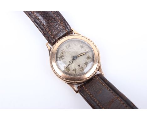
Lot 201
A 9ct gold Harwood wrist watch - John Harwood is credited for inventing the first automatically wound watch mechanism which was patented in 1924. The watch has no crown, instead the time is adjusted by rotating the bezel forwards and back. The watch contains an early form of bumper automatic movement with a toothed oscillating pendulum. The movement and face need cleaning. Dial discoloured. Case and glass with typical light scratches. Case 28mm

Lot 455
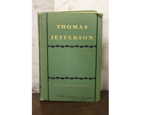
Typed letter signed ('G. Chinard') to Mrs Gaston Plantiff, regarding his biography of Thomas Jefferson and reading I felt highly complimented by your request and I am returning the book with the signature of the culprit. You will find enclosed a separate statement about a grievous error in the first edition. Ever since I discovered it I have been haunted by a sense of guilt and apologized to the readers whenever I had a chance to do it, one page, mailing folds, light creasing, 4to, 93 Mercer Street, Princeton, New Jersey, 11 December 1954.Also included is a copy of Thomas Jefferson by Chinard, signed and inscribed To Gaston Plantiff, this very imperfect study of a great American by a French admirer, December 11, 1954 in black ink on front free endpaper, wear to spine extremieties, dust jacket missing, hardback, 4to, Little Brown, 1929 (2)
Lot 108
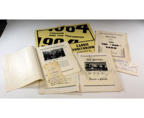
The Beatles autographs - Twist and Shout, hand signed Candie Gardens programme and other Pop Memorabilia - Guernsey Interest, a collection of rare pop memorabilia collected by Ivan Robert of 'The Roberts Brothers', the well-known Guernsey vocal duet, including a full set of The Beatles' autographs, signed in black pen on a facsimile photo pasted down in a concert programme, 'Baron Pontin, Presents, THE TOP "POP" SHOW, AT CANDIE GARDENS'; together with two related newspaper clippings, the first from the Guernsey Evening Press and Star, Weekender, dated Saturday, 13th February 1988, the headline, 'Robert Brothers take a trip down memory lane', the second from the Weekender, dated Saturday, 8th August 1998, titled '"Beatlemania" Roberts Brothers were on the bill'; plus other autographed memorabilia including a Candie Gardens programme signed by Gerry and the Pacemakers; and autographed Candie Gardens programme by Billy 'J' Kramer; a black and white postcard of Ivan and Bonny, The Robert Brothers, signed on reverse by 'The Dakotas'; a 'Freddie and the Dreamers' concert poster, Candie Auditorium, together with a Freddie and the Dreamers autographed pocket card handkerchief; a signed souvenir card from 'Musical Marie'; an autographed 'Elkie Brooks' photograph; and a 'Barron-Knights' card. * Provenance: Ivan Robert of 'The Robert Brothers'. ** The Beatles concerts were shown at 7pm and 9.15pm on Thursday 8th August, 1963 at the Auditorium Candie Gardens. The Roberts Brothers were one of the support acts on the day. Ivan and his brother 'Bonny' Roberts met The Beatles back stage and both passed around the programme and a black pen for them to sign. Ivan recalls that they signed the two programmes standing up and with nothing to lean on, whilst surrounded by a large crowd of fans, making the signing very difficult. 'Bonny's' programme was sold at auction approx. eleven years ago, realising a hammer price of £3800.

Lot 109
Of Channel Island and Dame of Sark historical interest, a vintage invalid carriage, tri-cycle design, mid-20th century, with removable wooden black painted hood, two spoked wheels to the rear, single front wheel steer, the wooden hood sign written in gold lettering with comical phrases, 'Tom Brewerd Est.1939, Rats cort, worts charmed, boils sucked, cats casterated, feret's as well', the opposite side with a quantity of vintage car badges to include Guernsey AA badges; East Africa AA badge; various other AA badges; RAC badges to include early examples; Royal British Legion Badge; together with a LMS built 1900 Horwich brass plaque, the rear with a 'Perkins Diesel' badge. * This carriage is the original invalid carriage first used by The Dame of Sark, Sibyl Hathaway, the first of three used by The Dame on the island during her lifetime. ** The carriage was later owned by Tom Breward, who was regularly seen driving it at the West Show, Liberation Day parade etc.
Lot 112
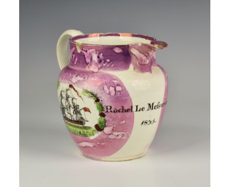
A Guernsey Sunderland pink lustre jug, mid-19th century, with loop handle and two decorated panels, named and dated below spout "Rachel Le Mefsurier, 1835", the first panel with transfer ware printed three masted sailing ship, the second with verse 'The lots of gold is much the lots of health' etc, 5¾in. (14.8cm.) high, a/f.
Lot 133
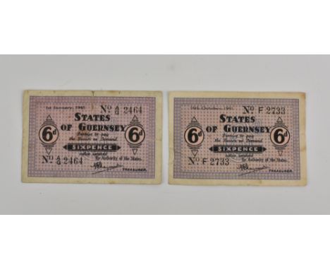
BRITISH BANKNOTES - STATES OF GUERNSEY - German Occupation, two German Occupation sixpence banknotes (GN35), the first dated 16th October, 1941, serial number F 2733; the second dated 1st January, 1943, serial number A/G 2464, both mauve and pink on white, reverse with guilloche, signed Marquand, notes very good, with light wear & creases. (2)
Lot 141
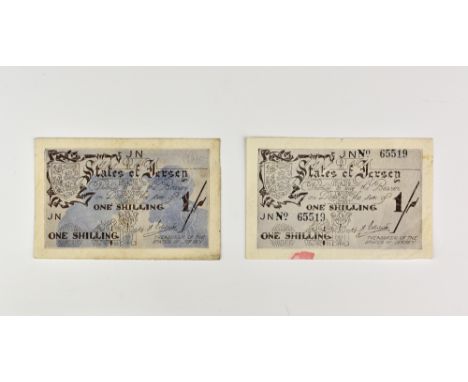
BRITISH BANKNOTES - STATES OF JERSEY - German Occupation, two One Shilling States of Jersey, German Occupation (error) banknotes, c.1941, the first, (JN24SA) serial number JN (unnumbered), treasurer Ereaut, brown lettering on grey with blue silhouette of elderly couple, the reverse with brown silhouette; the second, (JN24S), serial number 65519, this banknote with no blue silhouette to the obverse, notes designed by Edmund Blampied, fine, about UNC, with staining and edge wear, (note without silhouette with large red ink mark). (2)
Lot 76
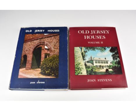
Stevens, Joan, née Collas, Old Jersey Houses and Those Who Lived in Them 1500-1700, (illustrated by Charles, Philip and Richard Stevens), La Société Jersiaise, 1972, illustrations, line drawings and maps, first published in 1965 by the auther, re-printed in 1966, and re-published in 1972 by La Société Jersiaise, this is therefore in effect the second edition, together with Old Jersey Houses and Those Who Lived in Them, volume II from 1700 onwards. (2)

Lot 35
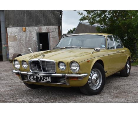
A 1973 Jaguar XJ6 Series II, registration number DBY 772M, chassis number 2N1905BW, engine number 7L74112S, Greensand. This well presented Jaguar was originally supplied by Henlys Ltd, Hendon, London to its first owner a Mr L L Lee was registered with Mr Lee's personal registration number LLL 1. The Jaguar cost Mr Lee £3,843.50 which included the fitting of the optional extras of electric windows £51.50, underbody protection £23.10 and front and rear mudflaps £14.86. Mr Lee was the owner of APT Controls Ltd the manufacturer of a traffic control light system who would own the Jaguar until 1997. The car changed hands and the private plate was retained and the Jaguar was registered DBY 772M. There is an extensive history file accompanying the XJ6 with the original Henly's bill of sale, receipts from Mr Lee's ownership, an advert for Mr Lee's company where the Jaguar featured, MOTs from September 1977 to March 2007 which confirms the mileage at just over 110,700 miles, receipts, the original owner's wallet with the Passport to Service, previous tax discs and spare keys. DBY 772M is still finished in its original colour scheme of Greensand with olive green leather interior. In remarkable original condition, this early Series II with continuous owner history offers a tremendous opportunity to purchase a still undervalued Jaguar. V5C, MOT and tax exempt See illustrations

Lot 39
A 1993 Rover Mini Mayfair, registration number K437 XRU, blue. This Mini Mayfair is in time warp condition having had one lady owner prior to our vendor. With only 17,700 miles on the odometer this automatic and genuine low mileage Mini is presented in very good condition. The car was maintained by the current owners garage and was gifted to him in 2011 when the first owner gave up driving. As one would expect the Mini has been maintained as necessary to keep the car in running condition. The Mini will be offered for sale with a history file containing previous MOTs, receipts, original dealer warranty, a stamped service book and handbooks. This low mileage and genuine Mini would be a great addition to any collection and is only reluctantly for sale due to the vendor finding increasingly difficult to drive (due to having knee trouble). V5C, MOT May 2019 See illustration
Lot 1
Augustine (Saint). Explanatio psalmorum, Basel: Johann Amerbach, 1497, 4 parts in 1 volume, 426 leaves (complete), Gothic types, text in double column, 65 lines and headline, rubricated manuscript initials around printed guide letters (heightened in metallic ink at a later date), several leaves sometime dog-eared and subsequently turned back up, sporadic ink- or oil-staining, heavier to title page and one ink-blot to part 4 Aa7 recto partially obsuring a word, but otherwise largely confined to margins, intermittent pale damp-staining to lower outer corners, a few leaves (part 3 bb2 and gg8-hh1, and part 4 Ee5) with shallow chips in the same place (text never affected), marginal repairs to part 2 B5 obscuring 2 side-notes and to part 4 Aa2 not affecting text, near-contemporary inscriptions to first title page, contemporary manuscript foliation, frequent contemporary Latin marginalia in red or black ink (occasionally trimmed), modern half calf, folio (29.5 x 20.5 cm) Goff A-1274, Hain-Copinger 1975. Second Amerbach edition, the first edition to contain the fourth part, 'Principalium sententiarum in explanatione libri psalmorum divi Augustini Annotatio'. The first edition overall, probably printed in the Netherlands in 1485, is considered unprocurable. Provenance: laid-in autograph letter signed from one William Lawson, dated Brasserton, 1 May 1860, to Reverend John Prior of Kirklington, presenting the volumeas 'a suitable companion for your Bellarmine on the Psalms', and claiming that this copy once belonged to Bishop Beveridge, that is, William Beveridge (1637-1708), Bishop of St Asaph. (1)
Lot 10
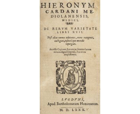
Cardano (Girolamo). De Rerum Varietate libri XVII. Post alias omnes editiones, nunc recogniti, castigati, infinitisque mendis repurgati, Lyon: Barth‚lemy Honorat, 1580, [16], 883, [48]pp., woodcut printer's device on title, folding plate and folding table, woodcut illustrations to text including full-page palmistry illustration, final blank of preliminary leaves present, several careful old ink (?editorial) deletions, each mostly of one or two sentences but including diagonal strikethrough for whole of pages 85 & 87, some spotting, recent blind-stamped antique-style tan calf with string ties, 8vo (165 x 105mm) First published in 1557 this is Cardano's second great encyclopaedia of natural science, the first being De Subtilitate (1550), and like it a dazzling display of polymathic learning. 'The two works, written in elliptical and often obscure Latin, contain a little of everything: from cosmology to the construction of machines; from the usefulness of natural sciences to the evil influence of demons; from the laws of mechanics to cryptology', (Dictionary of Scientific Biography). The cryptology element referred to is a description of what is now known as Cardano's Grille, which consisted of a sheet of stiff material with excisions for masking written text and, though somewhat crude, was used by some countries for diplomatic correspondence in the 16th and 17th centuries. (1)
Lot 100
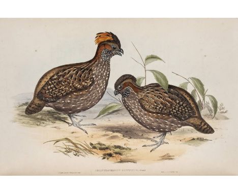
Gould (John). A Monograph of the Odontophorinae, or Partridges of America, 1850, 32 hand-coloured lithographed plates by Gould and H.C. Richter, printed by Hullmandel and Walton, slight fraying to a few fore margins, a few small marginal repairs, some light spotting, a couple of small holes to text leaf for first plate, 19th century Henry Sotheran bookseller label to front pastedown, all edges gilt, contemporary green morocco gilt, neatly rebacked with original spine relaid, edges a little rubbed and scuffed, folio (sheet size 55 x 36.5 cm) Anker 176; Great Bird Books, page 78; Nissen IVB 346. First edition of Gould's first monograph on game birds, dedicated to the ornithologist Charles Lucien Bonaparte, author of American Ornithology. Gould added 24 new species to the 11 American partridges previously recorded, many of which are illustrated and described here for the first time. (1)
Lot 101
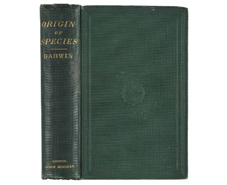
Darwin (Charles). The Origin of Species by Means of Natural Selection, or the Preservation of Favoured Races in the Struggle for Life, sixth edition, with additions and corrections, (twelfth thousand), John Murray, 1872, folding diagram (with small closed marginal tear) facing page 91, occasional spotting, ink ownership name of A. Ellison to front free endpaper and somewhat larger to half-title, the latter dated 1915, upper hinge slightly cracked, brown endpapers with small bookseller's ticket of James Miles to front pastedown, original green cloth gilt, slightly rubbed and bumped, old soiling mark on spine and upper joint beneath author's name, 8vo Freeman 392. 'The sixth edition, which is usually regarded as the last, appeared in February 1872. Murray's accounts show that 3,000 copies were printed, but this total presumably included both those with eleventh thousand on the title page and those with twelfth, the latter being notably less common. It is again extensively revised and contains a new chapter VII. This was inserted to confute the views of the Roman Catholic biologist St George Mivart. The edition was aimed at a wider public and printed in smaller type, the volume shorter again and giving the general impression of a cheap edition, which at 7s. 6d. it was. The title is changed to 'The Origin of Species', and a glossary, compiled by W.S. Dallas, appears. It is in this edition that the word 'evolution' occurs for the first time (twice on page 201 and four times on page 424). It had been used in the first edition of 'The Descent of Man' in the previous year, but not before in this work.' Uncommon. (1)

Lot 103
Highgrove Florilegium. The Highgrove Florilegium, Watercolours depicting Plants grown in the Garden at Highgrove, 2 volumes, The Prince's Charities Foundation/Addison Publications Ltd., 2008-09, 124 fine colour facsimile plates by Anne O'Connor, Beverly Allen, Josephine Elwes, Jenny Phillips, Sally Grosthwaite, Jill Coombs and many others, each with embossed blindstamp to lower outer corner giving the copyright, and the plate and edition number in pencil, the plates printed on American Cotton paper, the text on Somerset Bookwove, text decorations and endpaper designs by Richard Shirley Smith, original dark red quarter goatskin gilt, by Stephen Conway, after a design by James Brockman, with gilt hand-tooling by James and Stuart Brockman, dark red goatskin fore-edges, atlas folio, 66.5 x 48 cm Limited edition 129/175, signed in ink by Prince Charles to the preface page of the first volume. All 124 plates, each by a different artist, have been signed in pencil by that artist to lower margin. (2)
Lot 108
Schottus (Franciscus). Itinerario, overo nova descrittione de' viaggi principali d'Italia ... aggiontovi in quesi' ultima impression le descrittioni di Udine [etc.], Venice: Giovanni Pietro Brigonci, 1665, 3 parts in 1 volume, each with separate title page with woodcut device, 36 etched folding maps, plans and views (complete), later green half sheep, gilt spine, pebble-grain cloth sides, 12mo (13.5 x 7 cm) Cf. Cicognara 4149. A notably clean and fresh copy of the first guide-book to Italy as a whole. The additional material in this edition includes descriptions of Sicily, Malta, Palestine and elsewhere. (1)
Lot 11
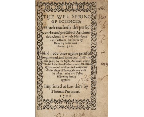
Baker (Humfrey). The Wel Spring of Sciences: Which teaches the perfect worke and practise of arithmeticke, both in whole numbers and fractions: set foorth by Humfrey Baker Londoner, 1562. And now once againe perused, augmented, and amended in all the three parts, by the sayde Authour: whereunto he hath also added certain tables of the agreement of measures and weights of divers places of Europe, the one with the other, as by the Table following it may appeare, Thomas Purfoote, 1591, title printed within typographical woodcut border (old marginal ink pen marks), black letter, some woodcut initials, colophon with large printer's woodcut device to final leaf verso, lacks A1 (blank?), B1-6 (folios 1-6 of main text), and final two leaves, 2E7-8 (both blank?), horizontal split to B7 without loss of text, paper flaw with closed tear and marginal loss to S4, not affecting text, some soiling and old dampstaining throughout, minor worm tracing to gutter and upper margins of some early leaves barely touching running heads or text, scattered old mostly marginal pen marks including ownership names of Thomas Hawkins and John Browne, recent antique-style calf gilt, 8vo (140 x 90mm) STC 1213. Humphrey Baker (flourished 1557-1574) was a writer on astrology and arithmetic. This popular primer went through many editions, with varying titles, being published first in 1562 as The Wellspring of Sciences. All sixteenth-century editions are uncommon, especially complete. (1)
Lot 115
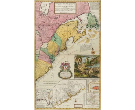
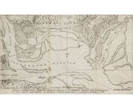
Moll (Herman). A New and Exact Map of the Dominions of the King of Great Britain on ye Continent of North America. Containing Newfoundland, New Scotland, New England, New York, New Jersey, Pensilvania, Maryland, Viginia and Carolina, sold by H. Moll over aginst Deverux Court in the Strand, circa 1715, engraved map on two conjoined sheets, contemporary outline colouring with later enhancement, inset maps of Charleston Harbor, 'A map of the principal part of North America', The Carolinas with the English, French and Indian settlements and Louisiana and the Gulf of Mexico, as well as Moll's famous depiction of beavers busy at work at the base of Niagara Falls, old folds, some professional restoration to margins and folds on verso, 1015 x 615 mm R. V. Tooley. The Mapping of North America, 55, variant state. "One of the first and most important cartographic documents relating to the dispute between France and Great Britain over boundaries separating their respective American colonies. The map was the primary exponent of the British position during the period immediately following the Treaty of Utrecht in 1713" (Degrees of Latitude). The large vignette gives the map it's popular name, the 'Beaver Map'. This shows an early view of Niagara Falls, with a colony of beavers at work in the foreground. The fur from the beaver was an important component of the fur trade and coupled with its reputation as an industrious animal, was deemed an appropriate image to represent the nation as a whole. This issue has Moll's address as 'against Deverux Court in the Strand' an address he occupied from 1710 -1732 (Worms & Baynton Williams. British Map Engravers). The date on the inset map of Louisiana is 1712 and it retains the early imprint of 'Cherecies 3000 men' and the inset map of Carolina is not divided into parishes, thus corresponding to Tooley's first state. (1)
Lot 117
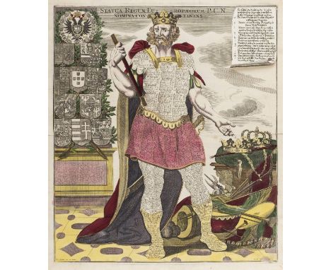
Seutter (Georg Matthaus). The 'Collosi Monarchic':- Statua Regum Europaeorum P.C.N. Nomina Continens, Icon Synoptica Sac. Rom. Electorum, Du Cum Principum, Collosi Monarchico. Statua Danielis Dan. II.31 [and] Pontificum Romanorum Series Chronologica, Augsburg, circa 1720, the set of four 'Colossi', engraved with contemporary hand colouring, heightened with gold, slight staining and occasional rust spots, Latin text with contemporary overslips in vernacular German on the key panels of two of the engravings (complete), each approximately 570 x 495 mm Colossus Danielis shows the figure of Colossus, with sword and sceptre, representing Daniel's interpretation of King Nebuchadnezzar's dream (Daniel 2:39-40). History's great empires are engraved on the breastplate: Oriental empires on the left leg, Western ones on the right. Mythical animals representing the great monarchies flank the figure. Pontificum Romanorum Series Chronologica shows a pope, sceptre in one hand, the other hand raised. On his body is a list of all the popes from the first to the seventeenth-century. In the background, to the left is the dome of St. Peters Rome, and to his right is a pile of papal paraphenalia:- a book, mitres, a hat, an incense burner. Statua Regum Europaeorum..., shows a king, flanked on one side by crowns, sceptres, weapons, musical instruments, etc and on the other by coats of arms. On his body and armour are listed the kings of the different European nations from the first to the seventeenth century, with their star signs and dates of their death. Icon Synoptica depicts the gigantic symbolic figure of an Elector in full robes, which are covered with listings of all the rulers of the Holy Roman Empire, princes, electors, and dukes. At the left is a pillar of heraldic coats of arms and on the right the crown and chair of state. Scarce as a complete set. (4)
Lot 121
Ramsay (David, of South-Carolina). The History of the Revolution of South-Carolina, from a British Province to an Independent State, 2 volumes, 1st edition, Trenton, Isaac Collins, 1785, five folding engraved maps by Thomas Abernethie (with a couple of short closed tears), Sketch of the Operations before Charleston map in the second state (with 'Approatches' corrected), lacking volume II title and both half titles, some light offsetting and spotting, light marginal water stain to a fw leaves in volume II, endpapers renewed, contemporary tree calf, modern calf rebacks, red stain to volume I lower cover, a little rubbed, 8vo Howes R36; Sabin 67690. Ramsay's account of the Revolutionary War in the South was mainly derived from the British Annual Register, the maps being amongst the earliest examples of indigenous American cartography. This work, and Ramsay's History of the American Revolution (1789) were the first two books to receive copyright in the United States (in 1790). (2)
Lot 129
Hall (Sidney). A New General Atlas with the Divisions and Boundaries carefully coloured; Constructed Entirely from New Drawings...., A new edition, published Longman, Brown, Green & Longmans, circa 1845, title and index, fifty-three double page engraved maps (complete as list) with contemporary outline colouring, some marginal dust and finger soiling, early 20th century ink manuscript ownership signature to rear endpaper, near contemporary ink manuscript ownership signature to front pastedown (Helen Hilton), contemporary half morocco with morocco gilt label to upper siding, heavily worn and frayed, boards detached, spine partially detached, folio By descent through the Hilton and Menzies family of Leigh in Lancashire. The most famous Hilton being James Hilton who wrote 'Goodbye Mr Chips' which was made into a film in 1942 staring Robert Donat and recently remade with Martin Clunes. He also wrote 'Lost Horizons', again made into a film staring Robert Colman and is best remembered for the fictional utopia 'Shangri-La'. He was also the author of 'The Story of Doctor Wassall', another Hollywood film this time staring Gary Cooper. The atlas is important for being one of the first to show the state of Texas as a separate and new entity. (1)
Lot 13
Savile (Sir Henry, editor). Rerum Anglicarum scriptores post Bedam praecipui, ex vetustissimis codicibus manuscriptis nunc primum in lucem editi, 1st edition, G. Bishop, R. Newbery, and R. Barker, 1596, 5 section titles with woodcut architectonic borders, woodcut head- and tailpieces and figurative initials throughout, variable spotting and browning, 2 small worm-tracks in lower margins never affecting text, marginal restoration to leaf Z5, quire 4E supplied from a shorter copy, closed transverse tear in final 3 leaves, occasional later marginalia, manuscript catch-title to fore edge, contemporary calf, blind panels to sides enclosing central strapwork lozenges, rebacked, restoration to corners, folio (32 x 19 cm) STC 21783; Cobham-Jeffery page 27 refers (Roger of Hoveden mentions Cyprus in the context of the Third Crusade). First edition of this important compilation of medieval chronicles, containing texts from William of Malmesbury, Henry of Huntingdon, Roger of Hoveden, Aethelweard, and pseudo-Ingulf. A second edition appeared at Frankfurt in 1601. (1)
Lot 131
Andrews (W.S.). Illustrations of the West Indies, Description of the Islands in the Caribbean Sea, Gulf of Mexico, and Florida, volume II only, Day & Son, [1861], title and 80 pages of text, 22 tinted lithographed plates, mostly after Thomas Dutton, including two double-page, one plate detached, first few leaves of text a little chipped to fore-edges, some light spotting and one or two small repairs to letterpress, one or two plates with minor loss to outer blank corners, presentation inscription to front endpaper 'Sarah Gilford from her brother Jacob, April 3rd 1868', all edges gilt, original blindstamped brown cloth gilt, rebacked with original spine relaid, a few light stains, oblong folio Sabin 1517. The second volume of Andrews' rare views of the West Indies (volume one containing only 8 uncoloured lithographic profiles of islands, aside from text). Only 3 copies have appeared at auction since 1981 (two of which were sold by Dominic Winter in 2012 and 2013). The author was a captain in the Royal Navy. (1)
![Li (Jie (1065-1110)). Li Mingzhong Yingzao Fashi (Building Standards), 8 volumes, [Shanghai?, 1925], Chinese text lithographe](https://cdn.globalauctionplatform.com/bc31b7f5-f407-4392-997f-a94400dd2197/7f2226f0-a113-46a7-d676-7794f2f51ed2/468x382.jpg)
Lot 134
Li (Jie (1065-1110)). Li Mingzhong Yingzao Fashi (Building Standards), 8 volumes, [Shanghai?, 1925], Chinese text lithographed on doubled leaves, frequent rubrication, numerous diagrams and figural illustrations in volumes 5-8, many of those in volumes 7-8 printed in colour, stab-stitched in original printed buff wrappers, stitching loose in places but bindings firm, small water-stains to wrappers of volumes 1, 7 and 8, original blue cloth portfolio, bone fasteners, printed label to front panel (with faint mark), pale mottling on rear panel, folio (34 x 23.5 cm) Literature: Jiren Feng, Chinese Architecture and Metaphor: Song Culture in the Yingzao Fashi Building Manual (Hong Kong, 2012); Li Shiqiao, 'Reconstituting Chinese Building Tradition: The Yingzao fashi in the Early Twentieth Century', in Journal of the Society of Architectural Historians, Vol. 62, No. 4 (December 2003), pages 470-489. 'The [Yingzao Fashi] was written by the imperial official in the Directorate of Construction Li Jie (1035?-1110, courtesy name Mingzhong) as a handbook for government standards for building methods, materials, and manpower. Not only the earliest but also the most comprehensive Chinese treatise on architectural technology to survive in its entirety, the YZFS is the most important primary text for the study of ancient Chinese architecture' (Feng, page 2). Li's text first appeared in 1103 and was rediscovered in 1919 by scholar Zhu Qiqian (1872-1962), who unearthed an imperfect, later transcription of a Song-dynasty reprint in Jiangnan library. He published a photolithographic edition in a reduced format the same year, but in his preface indicated several improvements required for a new edition, for which he had the illustrations entirely redrawn, commissioned a suite of new drawings from the master builder of the imperial palaces in Beijing, and had the painted decorations in chapters 33 and 34 printed in a lavish array of colours. 'The new edition of the Yingzao Fashi published in 1925 was exquisite. Bound into eight volumes with silk thread binding, it exemplifies the scholarly tradition of restoring classics, with its erudite preface and postscripts, demonstration of philological scholarship, completeness of chapters, sections, texts, and drawings, and imitation of the Song-dynasty calligraphy and printing style' (Li, page 477). (1)
Lot 136
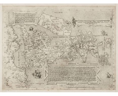
Lily (George), Britanniae insulae quae nunc Angliae et Scotiae regna continet cum Bibernia adiacente nova descriptio, Rome, 1558, uncoloured engraved map with the Sebastiano de Re da Chioggia imprint, orientated to the west with Ireland in the north, two panels with Latin text describe Ireland and Britain with a third containing the title, borders trimmed with new margins added, 400 x 550 mm R. W. Shirley. Early Printed Maps of the British Isles, 1477 - 1650, 63. This map is a close copy of the first separately printed map of the whole of the British Isles produced twelve years earlier by George Lily. Its overall scale is reduced by about a third from the 1546 state. The outline of England and Wales is based on a map of 1540 by Sebastian Munster. Many more place names and distinct topographical features are included. Ireland is still largely shapeless but Scotland is depicted with remarkable accuracy. This precise geographical depiction of Scotland is possible because Lily was able to consult a map of Scotland drawn by John Elden and presented to Henry VIII in 1538. Elden is known to have been in Rome in 1538. It is also possible that Lily had access to Hector Boece's Scotorium Historiae and a map thought to have been made by Alexander Lindsay while accompanying James V of Scotland of a tour of the kingdom. A striking feature of this map is that it uses distinctive and conventional signs to show county capitals and towns and the status of archepiscopal and episcopal sees. Oddly neither Oxford, Gloucester or Peterborough are marked as an episcopal see even though they were made so between 1541 and 1542. Shirley speculates that this omission could suggest that a pre 1541 map was used as a source, but could also betray the author's reluctance to acknowledge the newly created sees in light of the recent conflict between Rome and the English Crown. A rare map in remarkably good condition. (1)
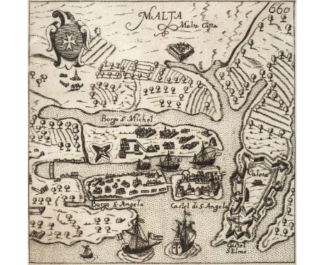
Lot 138
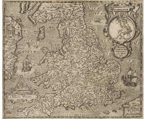
Camden (William). Britannia siue Florentissimorum regnorum, Angliae, Scotiae, Hiberniae, et insularum adiacentium ex intima antiquitate chorographica descriptio...., Nunc postrem• recognita, & magna accessione post Germanicam aeditionem adaucta, London: George Bishop, 1600, additional engraved title with small tear and loss to fore margin, woodcut Royal arms to letterpress title, additional title and two folding engraved maps by William Rogers (a little frayed at margins), eight full-page engraved illustrations, several woodcut illustrations and decorative initials, lacking final blank 3N4, early leaves close-trimmed at top margin with water stains, some light soiling and a few annotations, endpapers, modern panelled brown calf, small 4to STC 4507. The fifth edition and the first with maps. (1)
Lot 143
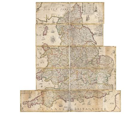
Lea (Philip), Untitled map taken from Christopher Saxton's large scale map of England and Wales first published in 1583, published by Philip Lea, Globemaker at ye Atlas and Hercules in Cheapside nere the corner of Fryday Street in London, [1687 - 1700], engraved map with contemporary outline colouring on ten sheets (complete), half and full compass rose, the sea decorated with numerous sea monsters and sailing ships, two mileage tables and a table of the longitude and latitude of the principal towns and counties, some restoration on the verso, to old folds, marginal closed tears and slight fraying, overall size 1415 x 1325 mm (width shown at widest point), R. W. Shirley. Early Printed Maps of the British Isles 1477 - 1650, 137, state 5. Christopher Saxton published his twenty sheet wall map in 1583. It was re-issued by Cade & Morgan in 1678. Philip Lea acquired the copper plates in about 1685 and re-published the map on a smaller scale designed to be used as a travelling map. He reduced the map to ten full sheets and four half sheets and removed a great deal of the sea, thus making the map relevant to land based travellers. The map - if partially conjoined - was pasted into five horizontal strips. The top three sheets made up of two sheets and the last two sheets made of two sheets with a half sheet pasted at each end. On this example the half sheets are attached. Philip Lea re-engraved the plates at least five times during his period of ownership. This example is his 5th and final state and therefore state 7 of a total of nine states. Lea moved from Poultry to Cheapside in 1687 and remained there until 1700. Following Lea's death, Anne his widow, re-engraved and re-issued the map with Richard Glynne in 1720 and Thomas & John Bowles & Son repeated this in 1758. Scarce. (1)
Lot 145
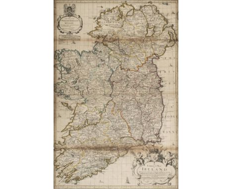
Willdey (George), A correct map of Ireland divided into its provinces, counties, and baronies shewing the roads and the distances of places in computed miles..., sold by George Willdey at the Great Toy Shop next the Dogg Tavern..., 1714, engraved map on two conjoined sheets with contemporary outline colouring, old folds, partially split and with slight browning along lower fold, very slight loss to printed image along this split, 920 x 625 mm Bonar-Law A. 54 (ii). The second state (the first is 1711), but retaining the Price, Senex and Maxwell imprint. Scarce. (1)
Lot 149
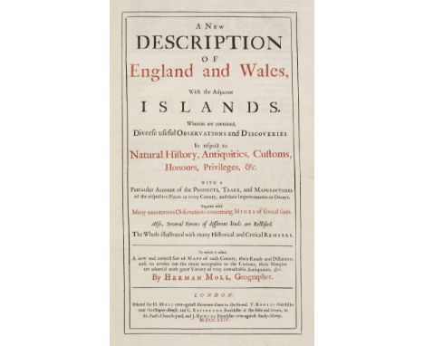
Moll (Herman). A New Description of England and Wales with the adjacent Islands. Wherein are contained diverse useful observations and discoveries in respect to natural history, antiquities, customs, honours, privileges &c..., 1st. edition, printed for H. Moll by T. Bowles, C. Rivington and J. Bowles, 1724, title page printed in red and black, frontispiece of an historical double page engraved map of England & Wales, preface, list of the counties of England & Wales, double page map of England & Wales and 48 uncoloured engraved maps (including four folding), occasional slight staining, map of Cornwall with marginal closed tear, index bound at rear, near contemporary armorial bookplate and ownership signature to front pastedown, contemporary speckled panelled calf, re-backed, bumped at extremities, folio Chubb CLX. Hodson 173. A fine copy of the first issue of the first edition without the plate numbers to the maps. Only half a dozen examples of this rare edition are known to exist, probably because a lack of advertising contributed to its commercial failure or possibly because it was in direct competition with a new edition of William Camden's 'Britannia' with a re-set text and fine large maps by Robert Morden re-issued in 1722. Paradoxically much of Moll's atlas was based on the maps of Robert Morden, a fact he acknowledged in his preface, but he claimed - not without some justification - to have corrected many errors in Camden's text. (1)
Lot 15
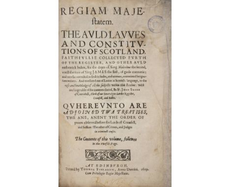
Skene (Sir John). Regiam majestatem. The Auld Lawes and Constitutions of Scotland, faithfullie collected furth of the Register, and Other Auld Authentick Bukes, fra the Dayes of King Malcolme the Second, untill the Time of King James the First, 1st edition in Scots, Edinburgh: Thomas Finlason, 1609, large woodcut head- and tailpieces and initials, damp-staining, japanese tissue-repairs along fore edges of first and last gatherings, Royal Historical Society ink-stamps to front free endpaper and title page, presentation slip tipped to former, contemporary vellum, front inner hinge split, soiled, loss to foot of spine and fore edge of front board, folio (27.5 x 18 cm), custom solander box STC 22626. First published in Latin the same year; this is usually described as the first edition in English but the language is in fact vernacular Scots. (1)
Lot 153
Stukeley (William). Stonehenge. A Temple Restor'd to the British Druids, 1st edition, London: W. Innys and R. Manby, 1740, engraved portrait frontispiece (offset to title), 35 engraved plates (including 9 folding), centre fold of plates 5 & 13 repaired to lower blank margins, plate 17 slightly cropped to image at fore-edges, bound with Abury, A Temple of the British Druids, with some others, Described. Wherein is a more particular account of the first and patriarchal religion; and of the peopling the British Islands, Volume the Second [the Description of Stonehenge forms the first Volume], 1st edition, London: Printed for the Author, 1743, large folding engraved frontispiece birdseye view of Avebury, 39 engraved plates (including 2 folding), plate 25 cropped to right side of image, few minor marks but generally very clean, some scattered spotting and minor toning to margins, modern half calf with maroon morocco title label to spine, folio Upcott 1320-1322 and 1325-1328. (1)
Lot 156
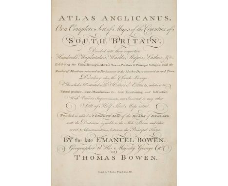
Bowen (Emanuel, and Bowen, Thomas). Atlas Anglicanus, or a complete sett of maps of the counties of South Britain; divided into their respective hundreds, wapontakes, wards, rapes, lathes &c..., 1st. edition, printed for T. Kitchin, [1767], calligraphic title page, two general engraved maps of England and Wales and forty-three county maps of England & Wales, all with contemporary outline colouring, very occasional marginal spotting, bookplate of Wm. Constable Esq., contemporary marbled boards, rebacked, slim upright folio, contained in modern cloth book box Chubb CCXXXII, Hodson 254. The maps in the 'Atlas Anglicanus' were reductions of the 'Large English Atlas', produced by the same authors. The maps were originally issued monthly in parts with three maps to a part. Initially all the maps were published without an imprint, which was added as production progressed, thus a complete atlas would often be comprised of maps from different states. This copy is an unusual combination of the first two states. (1)
Lot 157
Chapman (John, and Andr‚, Peter). A Map of the County of Essex from an actual survey made in MDCCLXXII, MDCCLXXIII and MDCCLXXIV by John Chapman and Peter Andr‚, [1770 or later], large scale engraved map with contemporary outline colouring, sectionalised and laid on linen, on four sheets, large compass rose, list of subscribers, inset plan of Harwich Harbour and map of Colchester, slight offsetting and browning, each sheet approximately 1140 x 1450 mm, contained in a contemporary morocco gilt box with lid, gilt crest of Charles Stanhope, 3rd Earl of Harrington, slight wear to extremities Provenance: Charles Stanhope, 3rd Earl of Harrington (1753-1829) served with British forces in North America and the Caribbean during the American War of Independence. He was also a politician, being elected MP for Thetford in 1774 and for Westminster from 1776 to 1779. Chapman and Andr‚'s meticulously detailed and accurate survey of Essex resulted in the finest large-scale map of the county. It was the first to depict minor roads, and included every country house and cottage, milestone, bridge, turnpike, creek, ferry, cliff and even duck decoy. It is unlikely that more than 300 copies of the first edition were sold, though there was a second smaller edition issued in 1785. (1)
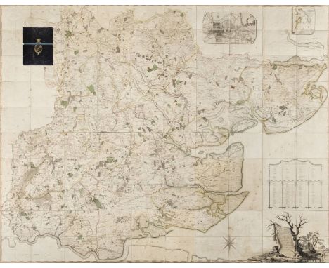
Lot 158
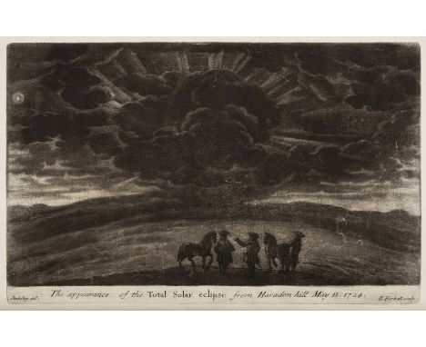
Stukeley (William). Itinerarium Curiosum: Or, An Account of the Antiquities, and Remarkable Curiosities in Nature or Art, Observed in Travels through Great Britain, 2 parts (Centuria I & II) in 2 volumes, 2nd edition, with large additions, 1776, engraved frontispiece to first volume only, 2 folding engraved maps, 206 engraved plates (including two folding & one folding), light stain to upper margin of 2C2 (verso) of first volume, contemporary calf gilt, contrasting green & red morocco labels to spines, joints a little cracked, folio Upcott xxx. The work contains a mezzotint plate of the appearance of the total solar eclipse from Haradon Hill on May 11, 1724. (2)
Lot 16
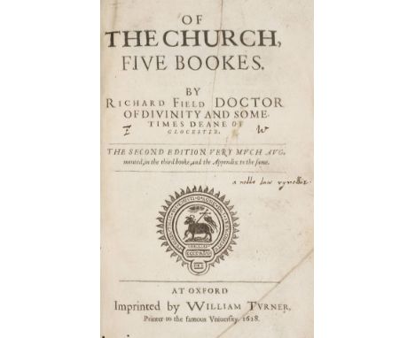
Field (Richard). Of the Church, five bookes, the Second Edition very much augmented, in the third booke, and the Appendix to the same, Oxford: William Turner, 1628, woodcut title vignette, head- and tailpieces and initials, final blank present, first quire slightly rumpled, minor worming in gutter, contemporary ownership inscription of one Edward Wynne to front free endpaper, later gift inscription to initial blank, early inscription in Welsh to title page, contemporary calf, later paper label to spine, loss to top compartment, extremities slightly rubbed, folio (28.5 x 17.5 cm) Madan I page 138; STC 10858. (1)
Lot 160
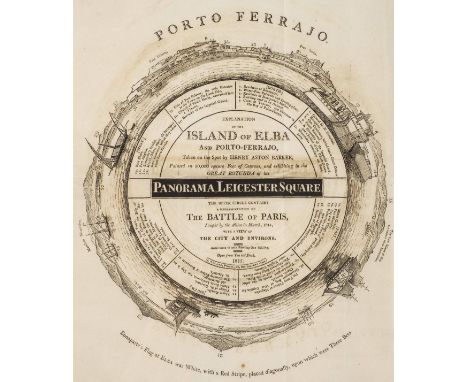
*Panoramas at Leicester Square. A collection of 36 plans and descriptions of the various panoramas exhibited at the Panorama, Leicester Square and the Panorama, Strand, London, 1803-40, comprising 21 wood folding wood engraved plans accompanied by descriptive text, 14 folding wood engraved plans without text, and one engraved plan of the Battle of Waterloo, partly hand-coloured, engraved by James Wyld after William Siborne, with accompanying descriptive text entitled Guide to the Model of the Battle of Waterloo, the folding plans various sizes (50 x 38 cm, 19.5 x 15 ins and smaller), a few waterstained or with minor soiling (generally in good condition), all disbound without covers, loose A rare collection of wood engraved plans and descriptions of the various panoramas exhibited to the public by Robert Barker, subsequently his son Henry Aston Barker, and later John and Robert Burford, mainly at the Leicester Square Panorama. First established in Leicester Square in 1793, Robert Barker's purpose built panorama rotunda exhibited 360 degree panoramas painted by the proprietors, with the exception in this present collection of the panorama of St. Petersburg, painted by John Thomas Serres (1759-1825), and the panorama of the Battle of Navarin, painted by John Wilson (1774-1855) and Joseph Cartwright (1789-1829). The folded single-sheet plans comprise: View of Paris. and, in the upper circle, the superb view of Constantinople, for a short time, 1803, Two views of Paris, 1803, Weymouth/Lord Nelson's glorious victory, gained over the French and Spanish fleets, off Trafalgar, circa 1805, Battle of Trafalgar, circa 1805 [watermarked 1802], View of Gibraltar and Bay, 1808, View of Flushing, during the siege, 1810, Grand View of La Valetta, the capital of Malta, circa 1810, View of Messina, in Sicily, circa 1810, View of the Grand Harbour of Malta, 1812, Representation of the Battle of Paris, 1815, Explanation of the view of Dover, circa 1816, View of the city of St Petersburg, 1819, Explanation of the view of Lausanne and Lake of Geneva, circa 1819, and St. Petersburg, painted by Mr. Serres, Royal Panorama, Lyceum, Strand. Plans with accompanying descriptive text comprise: A Short Dscription of Badajoz, 1813, Description of the View of the Battle of Vittoria, 1814, A Short Description of the Island of Elba, 1815, Description of a View of the Grand Harbour of Malta, and the City of La Valetta, 1839, Description of a View of the City and Bay of Dublin... painted by Robert Burford from drawings taken by himself in 1836, Description of a View of Rome painted by Robert Burford from drawings taken by himself in 1837, published 1839, Description of the Field of Battle... near Waterloo, 1816, Description of the View of Venice, 1819, Description of the View of Naples, 1821, Description of a View of the Ruins of the City of Pompeii, 1824, Description of a Second View of the Ruins of Pompeii, 1824, Description of a View of the City of Edinburgh, 1825, Description of a View of the City and Bay of Genoa, 1828, Description of a View of the City of Florence, 1831, Description of a View of the City of Milan, 1832, Description of a View of the Siege of Antwerp, 1833, Description of a View of the Great Temple of Karnak and the surrounding city of Thebes, painted by Robert Burford from drawings taken by Mr F. Catherwood, architect, in 1833, Description of a View of the City of Jerusalem, 1835, Description of a View of Isola Bella, the Lago Maggiore, and the surrounding country, painted by Robert Burford from drawings taken by himself in 1835, and A Description of the View of Berlin exhibiting in Barker's Panorama, Strand, 1814, and Guide to the Model of the Battle of Waterloo, circa 1815 (with partly hand-coloured engraved plan by James Wyld after W. Siborne). (26)
Lot 162
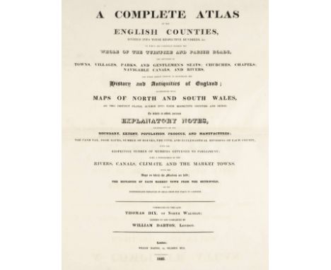
Dix (John Adams). AComplete Atlas of the English Counties, divided into their respective hundreds &c. On which are carefully marked the whole of the turnpike and parish roads, the situation of towns, villages, parks, gentemen's seats, churches, chapels, navigable canals and rivers and every object tending to illustrate the History and Antiquities of England..., commenced by the late Thomas Dix of North Walsingham; carried on and completed by William Darton, published William Darton, 1822, double page title, dedication and contents list, thirty-nine double page engraved maps and three folding (Yorkshire, North & South Wales), all with bright contemporary hand colouring, each map with an uncoloured vignette and a circular cartouche, some maps strengthened on recto at base of central fold, contemporary marbled boards with later half calf gilt binding, bumped, folio Chubb CCCLXXXVII. A rare atlas in fine contemporary colour. The maps carry a variety of dates between July 1816 and February 1821. Darton/Dix maps are sometimes found cut and dissected and it is probable that they were first sold individually in this state. (1)
Lot 164
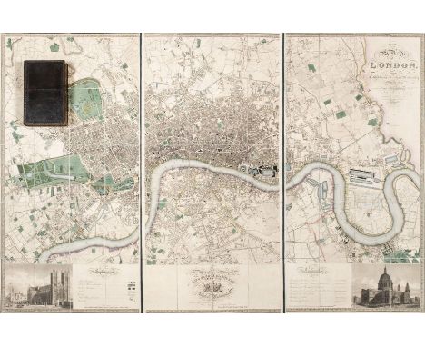
Greenwood (C. & J.). Map of London from an actual survey made in the years 1824, 1825 & 1826..., Greenwood, Pringle & Co., 1st edition, August 21st 1827, fine large scale map with contemporary hand colouring on three sheets, engraved by James and Josiah Neele, sectionalised and laid on linen, calligraphic cartouche, table of explantion, inset views of Westminster Abbey and St. Pauls, dedication to George IV, edged in green silk, marbled endpapers, overall size approximately 1255 x 1875 mm, contained in a contemporary green morocco gilt book box, all edges gilt, very slight wear to extremities Howgego, Printed Maps of London 1553 - 1850, 309, state 1. The Greenwood brothers Christopher and John spent three years preparing this remarkable new survey of London, prepared on the lavish scale of 8 inches to a mile, illustrating for the first time the planned development of Belgravia by Thomas Cubidt, the completion of the Grand Surrey Canal and Regent's Park one year before it was completed in 1828. (1)
-
596772 item(s)/page