We found 596772 price guide item(s) matching your search
There are 596772 lots that match your search criteria. Subscribe now to get instant access to the full price guide service.
Click here to subscribe- List
- Grid
-
596772 item(s)/page

Lot 209
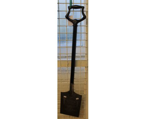
A silver plated and ebonised wooden commemorative spade presented to Miss Janet Loveluck by Mr Phillip Gaylard on behalf of the Bridgend Master Buildings Association on the occasion on her cutting the first sod of the Bridgend council housing scheme at Coity Road Bridgend May 25th 1922. Makers impressed marks J.D and S to the reverse. 35 inches long approximately. CONDITION REPORT: Overall generally tarnished, some scuffs and knocks to the handle but no serious damage noted.
Lot 475
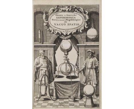
475 Guericke, Otto von. Experimenta nova (ut vocantur) Magdesburgica de vacuo spatio primùm à R.P. Gaspare Schotto, è Societate Jesu, & Herbipolitanae academiae matheseos professore. Amsterdam, Johannes Janssonius van Waesberge, 1672. In 2° (300 x 194 mm); [16], 244, [6] pagine. Antiporta figurata, ritratto entro ovale fuori testo, 20 figure incise nel testo e parzialmente a piena pagina, 2 tavole incise e ripiegate fuori testo (prima tavola leggermente corta in testa, leggere sporadiche bruniture.) Legatura coeva in piena pergamena rigida con titolo manoscritto al dorso. Bell’esemplare di questa prima edizione. Wheeler Gift 170: “Copies of the first edition are now very rare”; Dibner 55: “A book of prime importance in electrical discovery”. € 10.000,00
![481 Mercuriale, Girolamo. De arte gymnastica libri sex. Venezia, Giunta, 1573. [12], 308 [i.e. 312], [28] pagine. Marca tipo](https://cdn.globalauctionplatform.com/846c05cf-ea56-4a7b-9ea4-a55c00f8a07a/eda59f90-9be0-4341-d675-e4831e88bd6b/468x382.jpg)
Lot 481
481 Mercuriale, Girolamo. De arte gymnastica libri sex. Venezia, Giunta, 1573. [12], 308 [i.e. 312], [28] pagine. Marca tipografica al frontespizio ed in fine volume, 24 incisioni in legno nel testo o a piena pagina (brunite alcune carte.) Legatura del secolo XVII in piena pergamena, dorso liscio con titolo impresso in oro, tagli rossi a spruzzo. Bell’esemplare della seconda edizione, la prima illustrata. Garrison Morton 1986, 1 (per l’edizione del 1569): “First illustrated book on gymnastics. It is the foundation stone of later work on the subject and is important for the study of gymnastics among the ancients. It includes some excellent woodcuts”; Durling 3088: “Designed for the author by Pirro Logorio and cut by Cristoforo Coriolani”. € 400,00
Lot 74
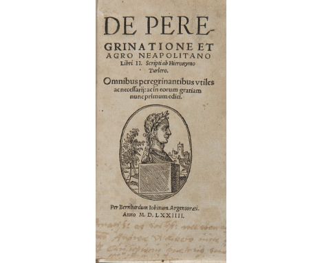
74 Turler, Jerome. De peregrinatione et agro neapolitano libri II. Strasburgo, Bernard Jobin, 1574. In 8° (148 x 90 mm); [16], 107, [3] pagine con una delle due carte bianche finali presente. Vignetta xilografica al frontespizio (manca l’ultima carta bianca, bruniture.) Legatura di poco posteriore in piena pergamena con titolo manoscritto al dorso. Ex libris di Jacques Barrelle. Prima rarissima edizione di questo manuale rinascimentale per il viaggiatore, uno dei primi di questo genere, in esemplare con ex libris ottocentesco della libreria francese Jacques Barrelle “près des Escaliers du Dôme à Milan”. “Jerome Turler […] was the first and most influential of these new theorists of the road” (Wes Williams, Pilgrimage and Narrative in the French Renaissance, New York, Oxford University Press, 1998, p. 59). € 250,00
Lot 1173
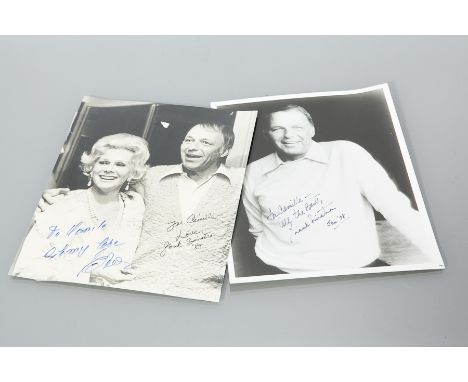
TWO FRANK SINATRA AUTOGRAPHED PHOTOGRAPHIC PRINTS the first inscribed in black ink, 'To Camille, all the best, Frank Sinatra, Jan '78', 25.5cm long, 20.5cm wide; the second inscribed in black ink 'For Camille, Love, Frank Sinatra, '84', 25cm long, 20cm wide Note: These photographic prints form a larger part of an autographed memorabilia collection held by the vendor. Although there is no documentary provenance to say that these signed photographic prints are authentic, McTear's has no cause to doubt their legitimacy. Without provenance, the buyer accepts that they are fully satisfied with the authenticity of the autographs.
Lot 1180
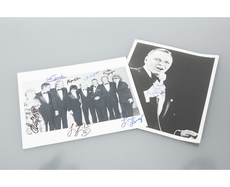
TWO 'OLD HOLLYWOOD' AUTOGRAPHED PHOTOGRAPHIC PRINTS the first of Frank Sinatra, inscribed in blue ink 'For Camille, Love, Frank Sinatra, '79', 25cm long, 19cm wide; the other depicting Liza Minelli, Kirk Douglas, Frank Sinatra and others, signed in blue and black ink, 20cm long, 25cm wide Note: These photographic prints form a larger part of an autographed memorabilia collection held by the vendor. Although there is no documentary provenance to say that these signed photographic prints are authentic, McTear's has no cause to doubt their legitimacy. Without provenance, the buyer accepts that they are fully satisfied with the authenticity of the autographs.
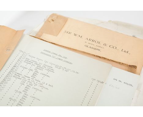
Lot 993
SELECTION OF DRAWING LISTINGS OF SIR WM. ARROL & CO. LTD. FOR BATTERSEA POWER STATION including three folios for Battersea A Power Station project, 'Battersea Index Jobs Nos. 550, 551, 555, 556, Box 205' dated 29.1.30, 'Progress Sheets, Drawings, Job Nos. 552 etc., Box 208' and 'Pump House, Orders'; together with a comprehensive folder labelled 'London Power Co. Battersea B', housing a complete listing of the drawings from the Battersea B Powerstation project with annotations, These documents appear to be mainly listings of the many drawings and progress sheets that Sir WM. Arrol & Co. Ltd did for the steelwork for both projects, along with a small group of drawings and calculations for steel used in the Pump House of Battersea A, each 34cm high Note: The structure of Battersea Power Station comprises two individual power stations, built in two stages in the form of a single building. 'Battersea A' Power Station was built in the 1930s, with 'Battersea B' Power Station to the east in the 1950s. The two stations were built to an identical design, providing the long-recognized four chimney layout. Construction of the first phase, the A Station, began in March 1929. The main building work was carried out by John Mowlem & Co, and the structural steelwork erection carried out by Sir William Arrol & Co. Other contractors were employed for specialist tasks. Most of the electrical equipment, including the steam turbine turbo generators, was produced by Metropolitan-Vickers. The building of the steel frame began in October 1930, once completed the construction of the brick cladding began in March 1931.
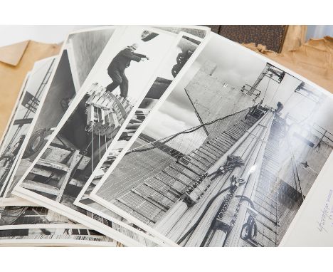
Lot 995
COLLECTION OF ORIGINAL SITE PHOTOGRAPHS OF THE CONSTRUCTION OF THE FORTH ROAD BRIDGE BY THE STEEL CONTRACTOR SIR WM. ARROL & CO. LTD. including two packs of site photographs that appear to be the project copies that were viewed by members of the company and stored in the main office, each card packet labelled 'Forth Rd. Bridge Site Photographs, Do Not Take Any Photographs From File Without Notifying S. Fenton' each also labelled 'Nos. 151-300' and 'Nos. 301-475' respectively, almost all of the photographs each have a printed stamp by 'W. Ralston Ltd. Glasgow, Negative No.' and a number in pencil, as well as a typed label with a code number, title and a date, the subject of the photographs covers mainly the making of the steel, the yards the steel was stored at, the methods used in making the bridge and quality inspection as the project continued, the first pack has mainly the completion of the steel towers, the cable anchors and the start of running the main suspension cable to either side, the second packet has mainly the running of the cable and anchoring them inside the ground, the casing of the finished cable and the suspension of the roadway until completion, because of the numbering system it can be assumed that the first packet (1-150) has been lost or was taken elsewhere leaving these later two of the three; together with a folio of loose photographs including the steel production, site photographs, opening ceremonies and other parts of the project Note: The final construction plan was accepted in February 1958 and work began in September of that year. Mott, Hay and Anderson and Freeman Fox and Partners carried out the design work and a joint venture of Sir William Arrol & Co., Cleveland Bridge & Engineering Company and Dorman Long constructed the bridge. It was the longest steel suspension bridge in Europe at the time it was opened by Queen Elizabeth II and the Duke of Edinburgh on 4 September 1964.

Lot 11
Apollo 12 Crew Signed FDC Charles Conrad, Richard Gordon & Alan Bean signed Apollo 12 FDC. Apollo 12 was the sixth manned flight in the United States Apollo program and the second to land on the Moon (an H type mission). It was launched on November 14, 1969 from the Kennedy Space Centre, Florida, and four months after Apollo 11. Mission commander Charles Pete Conrad and Lunar Module Pilot Alan L. Bean performed just over one day and seven hours of lunar surface activity while Command Module Pilot Richard F. Gordon remained in lunar orbit. The landing site for the mission was located in the south eastern portion of the Ocean of Storms. Unlike the first landing on Apollo 11, Conrad and Bean achieved a precise landing at their expected location, the site of the Surveyor 3 unmanned probe, which had landed on April 20, 1967. They carried the first colour television camera to the lunar surface on an Apollo flight, but transmission was lost after Bean accidentally destroyed the camera by pointing it at the Sun. On one of two moonwalks, they visited the Surveyor and removed some parts for return to Earth. The mission ended on November 24 with a successful splashdown. Good condition. Item comes with lifetime guarantee of authenticity and COA from an AFTAL registered dealer.

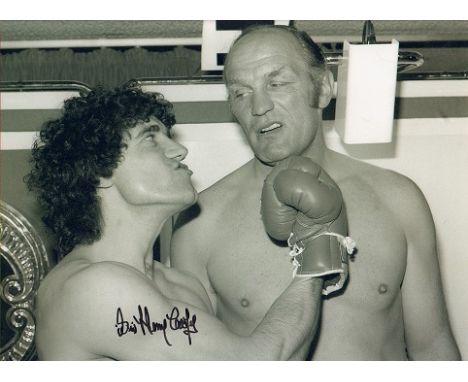
Lot 522
Sir Henry Cooper signed 16 x 12 black and white boxing photo, amusing image with Kevin Keegan. English heavyweight boxer known for the sheer power of his left hook, Enry's 'Ammer, and his knockdown of the young Muhammad Ali. Cooper held the British, Commonwealth and European heavyweight titles several times throughout his career, and unsuccessfully challenged Ali for the world heavyweight championship in 1966. Following his retirement from the sport, Cooper continued his career as a television and radio personality and was enormously popular in Britain: he was the first (and is today one of just three people) to twice win the public vote for BBC Sports Personality of the Year Award and is thus far the only boxer to be awarded a knighthood. Good condition. Item comes with lifetime guarantee of authenticity and COA from an AFTAL registered dealer.
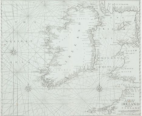
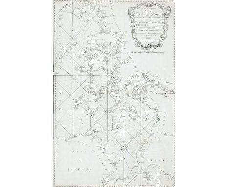
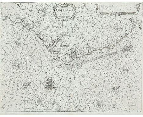
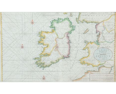
Lot 10
Goos, Pieter (1615-1675) Engraver, bookseller and publisher, of Amsterdam, first published De Lichtende Columne ofte Zee-Spiegel in 1650. There is only one chart of Ireland and for this he used the plate of Theunis Jacobsz, unchanged, so loose charts cannot be assigned to this book with certainty. In 1666 he brought out his De Zee-Atlas Ofte Water-Weereld with a chart of Ireland which has his name. The source of the first state dated 1663 is unknown but those for later editions of the Zee-Atlas were modified as described below.A Chart of Ireland and the Irish Sea (1663)“Paskaarte om Achter Yrlandt om te Zeijlen van Hitland tot aen Heijsat Nieuwlycx Utgegeven t`Amsterdam bij Pieter Goos op het waater in De Verguide-Zee-Spiegel. Anno 1663.” (1663). Verso blank. 550 x 445.
Lot 114
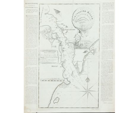
George JohnstonChart of the Entrance to Strangford Lough This is an isolated chart, surveyed and presumably published by George Johnston in 1755. The first state gives no engraver's name, but the second state gives it as John Ridge of Dublin.It shows the entrance to Strangford Lough, with the mainland from Gunn's Island to Castle Ward, and the Ards coast from Millin Bay round Ballyquintin Point to Ballywhite Bay. It gives soundings and anchorages but little inland detail. The title in the top right corner reads Strangford River from an Accurate Survey by George Johnston of Portaferry Pilot 1755, and is depicted on a shell supported by a sea-god. The cartouche is very similar to that of Greenvile Collins' title page for his Great Britains' Coasting Pilot, except that the figure is facing left instead of rig ht. There are three ships alongside this figure, and some houses, castles and churches are illustrated. In the middle left is an Explanation or key to the symbols and depth markings. In the lower left corner is A Scale of Two English Miles 2[= 119 mm.]. There is one compass rose showing north to the top, but no scale of latitude or longitude. The frame consists of two parallel lines. 295 x 525 mm.
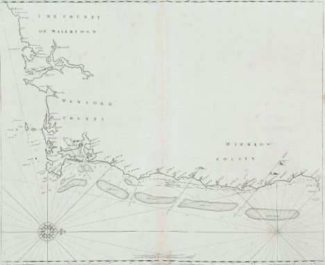
Lot 123
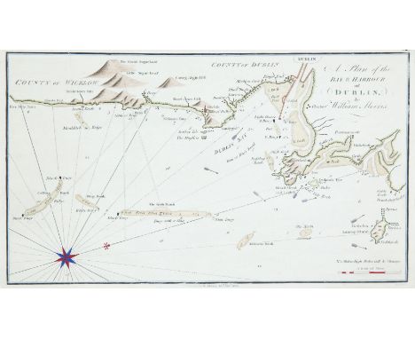
William MorrisChart of Dublin BayThis is the last chart in William Morris's Plans of the Principal Harbours, Bays & Roads in St. George's and the Bristol Channels, which was first published in 1748 by his father, though this chart only appeared in this edition of 1801.It shows the Irish coast from Five Mile Point, county Wicklow, to Lambay Island. The title is unframed in the top right corner and reads A Plan of the Bay and Harbour of Dublin by William Morris and an imprint below the lower border reads Publish'd by W. Morris 25th Novr. 1800. Simpkins fe.. In the lower right corner is A Scale of Miles 4 [= 50 mm.]. There are soundings along the whole coast and round the sandbanks, as well as signs for the currents and lighthouses. One compass rose shows north to the top right. 320 x 187 mm.
Lot 127
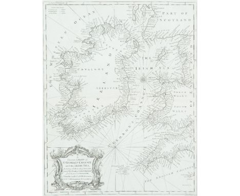
Ralph William Seale 1732-1775Chart of Ireland and the Irish Sea This is found with other maps and charts at the end of Volume 3 or 4 of Tindal's Continuation of Rapin's History of England, first published between 1744 and 1747, and in the second editon of 1751.The title in the lower left corner is in an ornate scalloped frame and reads A Correct Chart of St. George's Channel and the Irish Sea, Including all the Coast of Ireland and ye West Coast of Great Britain from Cantire to Portland Isle: From the latest & best Observations. For Mr. Tindal's Continuation of Mr. Rapin's History. 375 x 475 mm.
Lot 134
John Seller (1634-1697)Chart of Ireland and the Irish Sea This chart does not appear in the 1690 edition of The English Pilot, Southern Navigation, and is first seen in the 1701 edition. Three different plates were made, each occurring in two distinct states. The chart was replaced in an edition of c. 1769. It also occurs on its own in the Atlas Maritimus Novus or New Sea-Atlas by Mount and Page and in later editions of The English Pilot, Third Book.It shows all Ireland and the Irish Sea, with the British coast from Cornwall to the Mull of Galloway. The Ards peninsula and Island Magee are shown as separated from the mainland. The title (unframed) in the lower right corner reads A Chart of the Coasts of Ireland and Part of England. Below this is a scale of English and French Leagues 20 [= 80 mm.]. There is one compass rose showing north to the top and there are scales of latitude at each side. This edition from 1743. 555 x 445 mm.
Lot 134A
John Seller (1634-1697)Chart of the South-East Coast of Ireland This chart appears first in Seller's The English Pilot, Southern Navigation of 1690, and it was unchanged in editions up to 1715. Later editions used new plates.It shows the coast from Waterford to Dalkey and has no title. The scale in the lower centre reads A Scale of English and French Leagues 20 in a Degre 5 [= 102 mm.]. There is one compass rose, with 16 points, showing north to the right, and there are a scales of latitude at top and bottom. This edition from the first English plate without title or insert. 535 x 440 mm.
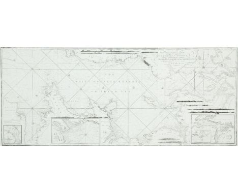
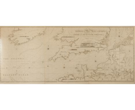
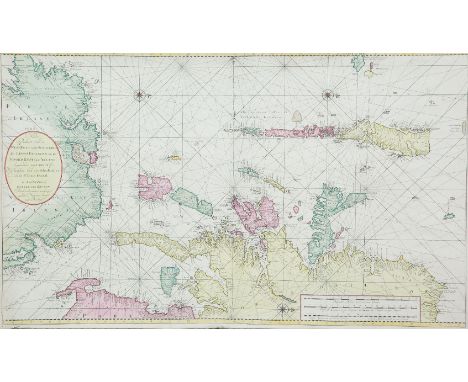
Lot 151
William HeatherChart of the St. George's and English Channels The dedication is unframed in the top centre and reads To the Right Honorable the Master, Wardens and Elder Brethren of the Trinity House this Chart of the English Channel Is most humbly dedicated by their obedient Servant William Heather. This was first produced as a separate chart in 1794 on three sheets which may be joined together. A new edition was printed in 1805.It shows the Irish coast from county Clare to Wexford, the British coast from Barmouth to Yarmouth and Europe from Britany to Haarlem in the Netherlands. There are detailed soundings round the coast and in the open sea, as well as tide and current marks and notes on the sea bottom. Below the frame is the imprint Published as the Act directs, July 12th 1794 by W. Heather, at the Navigation Warehouse, No. 157 Leadenhall Street, London. The navigational route through the English Channel is marked by a hand and two ships on the left sheet and two further ships on the middle sheet. There are scales of latitude and longitude east and west from London on all four sides, as well as three coastal profiles in the top centre. Magnetic variation on the left sheet is dated 1794 and there are four compass arrows showing north to the top as well as four ships. (1,890 x 775 mm.).There are six insets in the right sheet, each with one compass arrow showing north to the top:1. (142 x 345 mm.) entitled Portsmouth, with a Scale of Miles 5 [= 30 mm.].2. (100 x 120 mm.) entitled Sketch of the Situation of The Owner's Light by order of the Trinity House, 1794.3. (235 x 125 mm.) entitled Dartmouth, with a Scale of half a Mile 1/2 [= 45 mm.].4. (175 x 175 mm.) entitled Falmouth, with a scale of One Mile [= 30 mm.].5. (175 x 165 mm.) entitled Plymouth, with a scale of One Mile [= 30 mm.].6. (315 x 192 mm.) entitled Downs and Margate, with a Scale of Miles 3 [= 41 mm].1,890 x 775mm
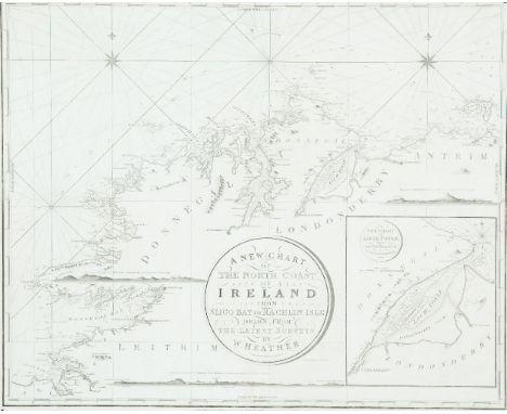
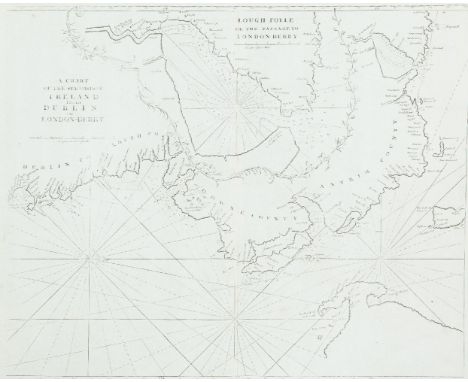
Lot 152
William HeatherChart of the North Coast of Ireland The title is in a circular frame in the centre and reads A New Chart Of The North Coast of Ireland From Sligo Bay to Rachlin Isle Drawn From The Latest Surveys for W. Heather. 1807. Below the title is J. Stephenson Engraver. Below the frame is the imprint London. Published as the Act directs, January 1st 1807, by William Heather, at the Navigation Warehouse, No. 157 Leadenhall Street. This is part of a series of three charts covering the north, west and south coast of Ireland, first produced in 1807. It overlaps chart V to include Sligo town.It shows the coast from Ballycastle and Rathlin Island, county Antrim, to Achris Head, county Sligo. There are scattered coastal profiles, notes on the sea bottom, numerous soundings and tide and current marks. There are also two compass roses showing north to the top and scales of latitude and longitude west from Greenwich, on all four sides. Magnetic variation is dated 1807.In the lower right corner is an inset (265 x 230 mm.) entitled A New Chart of Loch Foyle, being the Entrance to Londonderry with a Scale of Miles 6 [= 70 mm.] and one compass rose showing north to the top. 780 x 645mm.
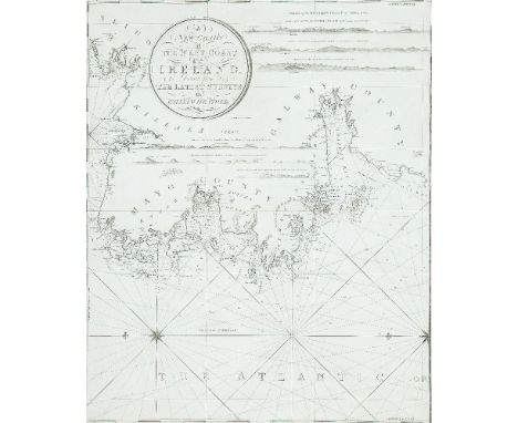
Lot 154
William HeatherChart of the West Coast of IrelandThis is part of a series of three charts covering the north, west and south coast of Ireland, first published in 1807. It overlaps chart IV to include Sligo town and butts on the chart VI to the south.It shows the coast from Sligo town to Mutton Island in Galway Bay.The title is in a circular frame in the centre and reads A New Chart Of The West Coast of Ireland. Drawn from The Latest Surveys by William Heather. 1807. This is part of a series of three charts covering the north, west and south coast of Ireland, first published in 1807. It overlaps chart IV to include Sligo town and butts on the chart VI to the south.It shows the coast from Sligo town to Mutton Island in Galway Bay. The title is in a circular frame in the centre and reads A New Chart of the West Coast of Ireland. Drawn from The Latest Surveys by William Heather. 1807 Below the title is Stephenson Engraver and below the frame is the imprint London. Published as the Act directs. January 1st 1807, by William Heather, at the Navigation Warehouse, No. 157 Leadenhall Street. There are scattered coastal profiles, notes on the sea bottom, tide and current marks and numerous soundings. There are also one and a half compass roses showing north to the left and scales of latitude and longitude west from Greenwich on all four sides. Magnetic variation is dated 1807. 625 x 785 mm.
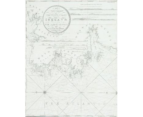
Lot 155
William Heather VChart of the West Coast of Ireland The title is in a circular frame in the centre and reads A New Chart Of The West Coast of Ireland. Drawn from The Latest Surveys by William Heather. 1807. This is part of a series of three charts covering the north, west and south coast of Ireland, first published in 1807. It overlaps chart IV to include Sligo town and butts on the chart VI to the south.It shows the coast from Sligo town to Mutton Island in Galway Bay. Below the title is Stephenson Engraver and below the frame is the imprint London. Published as the Act directs. January 1st 1807, by William Heather, at the Navigation Warehouse, No. 157 Leadenhall Stret. There are scattered coastal profiles, notes on the sea bottom, tide and current marks and numerous soundings. There are also one and a half compass roses showing north to the left and scales of latitude and longitude west from Greenwich on all four sides. Magnetic variation is dated 1807.State 3 (1833). There is no date in the title but the date in the title frame now reads Additions to 1833. The Norrie and Stephenson references in the frame are as before. The magnetic variation is undated. (625 x 785 mm.).
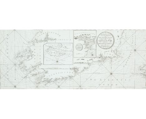
Lot 156
William HeatherChart of the South Coast of IrelandThis is part of a series of three charts covering the north, west and south coast of Ireland, first produced in 1807. It butts on to chart VI to the north.It shows the coast from county Clare to Arklow, county Wicklow, and part of south-west Wales. The title is in a circular frame in the centre right and reads A New Chart of the South Coast of Ireland Drawn from the Latest Surveys by Wm. Heather. 1807775 x 1,290mm
Lot 157
William Heather IChart of the St. George's and English Channels (1,890 x 775 mm.)This was first produced as a separate chart in 1794 on three sheets which may be joined together. A new edition was printed in 1805.It shows the Irish coast from county Clare to Wexford, the British coast from Barmouth to Yarmouth and Europe from Britany to Haarlem in the Netherlands. The dedication is unframed in the top centre and reads To the Right Honorable the Master, Wardens and Elder Brethren of the Trinity House this Chart of the English Channel Is most humbly dedicated by their obedient Servant William Heather. There are detailed soundings round the coast and in the open sea, as well as tide and current marks and notes on the sea bottom. Below the bottom border is the imprint Published as the Act directs, July 12th 1794 by W. Heather, at the Navigation Warehouse, No. 157 Leadenhall Street, London. The navigational route through the English Channel is marked by a hand and two ships on the left sheet and two further ships on the middle sheet. There are scales of latitude and longitude east and west from London on all four sides, as well as three coastal profiles in the top centre. Magnetic variation on the left sheet is dated 1794 and there are four compass arrows showing north to the top as well as four ships.There are six insets in the right sheet, each with one compass arrow showing north to the top:1. (142 x 345 mm.) entitled Portsmouth, with a Scale of Miles 5 [= 30 mm.].2. (100 x 120 mm.) entitled Sketch of the Situation of The Owner's Light by order of the Trinity House, 1794.3. (235 x 125 mm.) entitled Dartmouth, with a Scale of half a Mile 1/2 [= 45 mm.].4. (175 x 175 mm.) entitled Falmouth, with a scale of One Mile [= 30 mm.].5. (175 x 165 mm.) entitled Plymouth, with a scale of One Mile [= 30 mm.].6. (315 x 192 mm.) entitled Downs and Margate, with a Scale of Miles 3 [= 41 mm]. (3 sheets joined)1,890 x 775mm.
Lot 160
HuddartChart of the South-West Coast of IrelandThis chart was first published in 1780 by Sayer and Bennett on three sheets, and was included in their East India Pilot of 1781. The title is in a classical rectangular frame in the top right corner and reads A Chart of the West and South-West Coast of Ireland from the Mouth of the River Shannon to Waterford Haven on the same Scale as the Chart of St. George's C hannel. By Capt. Jos. Huddart. London. Printed for R. Sayer and I. Bennett, Fleet Street, As the Act directs, August 1st 1780. Below this is an unframed Scale of Nautic Leagues 20 to a Degree 8 [= 156 mm.].1.270 x 785 mm.
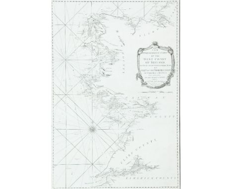
Lot 167
HuddartChart of the West Coast of IrelandThe title is in a scalloped frame in the centre right and reads A New Hydrographical Survey of the West Coast of Ireland, from the Shannon Mouth to Urris Head; with Part of the North Coast from Urris Head to Milk Haven: being a Continuation of the Marine Surveys made by Capt. Joseph Huddart. London. Printed for R. Sayer & J. Bennett, Fleet Street, as the Act directs 19 Septr. 1781.This chart was first published on one sheet in 1781 by Sayer and Bennett and included in their East India Pilot of that year. It was reprinted in 1786 by Robert Sayer, and again in 1794 by Laurie and Whittle for The Irish Coasting Pilot and The Coasting Pilot of Great Britain and Ireland. It was later copied and translated by the French Depot de la Marine, being published in the Neptune Francois in 1803. It was finally included as the fourth chart in Laurie and Whittle's The North-about Navigator, published in 1818.525 x 775 mm.
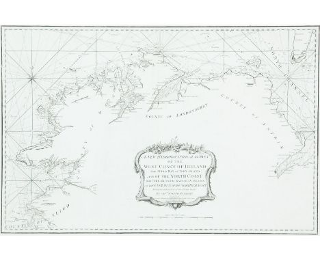
Lot 168
HuddartChart of the North Coast of IrelandThe title is a scalloped frame in the bottom centre and reads A New Hydrographical Survey of the West Coast of Ireland from Sligo Bay to Tory Island and of the North Coast from Tory Island to Raughlan Island; with the Entrance of the North Channel Being a Continuation of the Survey made by Captn. Joseph Huddart. London. Printed for R. Sayer & J. Bennett, Fleet Street, as the Act directs 19 Septr. 1781.This chart was first published in 1781 by Sayer and Bennett and was included in their East India Pilot of that year. It was reprinted in 1794 by Laurie and Whittle for their Irish Coasting Pilot and Coasting Pilot of Great Britain and Ireland. It was reprinted again in 1812 and in this form was included as the fifth chart in Laurie and Whittle's The North-about Navigator of 1818. 795 x 525 mm.
Lot 169
HuddartChart of the N.E. Coast of Ireland and S.W. ScotlandThe title in a scalloped frame in the top right corner reads A New Chart of the West Coast of Scotland From the Mull of Galloway to Dunan Point in Sky; including the Western Isles of Ila, Jura, Mull, Tire-iy, Coll, Rum. &c. with the Opposite Coast of Ireland and the North Channel. Being a Continuation of the Hydrographical Surveys made by Capt. Joseph Huddart. London. Printed for R. Sayer and J. Bennett; No. 53 Fleet Street. As the Act directs 29 Octr. 1781.This chart was first published on one sheet in 1781 by Sayer and Bennett and included in The East India Pilot of 1781. 935 x 615mm.
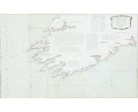
Lot 170
HuddartChart of the East Coast of Ireland and the Irish SeaThe title is in a scalloped frame with a cannon, flags, nets and an anchor, and reads A New and Original Hydrographical Survey of the North and St. George's Channel Extending from Arran to Caldy Island on the British Coast and from Skerries Port Rush to Bannow on the Irish Coast By Capt. Joseph Huddart London Published 12th May 1794 by Laurie & Whittle No. 53 Fleet Street.This is a reduced version of Huddart's chart of the area which was first published in 1779 by Sayer and Bennett. This version was published in 1794 by Laurie and Whittle on two sheets and was included in their Irish Coasting Pilot (1795). It was enlarged southwards by a small third sheet, to measure 1200 x 665 mm., and this form is the first chart in The North-about Navigator, published by Laurie and Whittle in 1818.It shows the whole Irish coast from Baginbun Head, county Wexford, to Portrush, county Antrim, and the British coast from Caldy Island in Pembrokeshire, to the Mull of Kintyre in Scotland, with detailed soundings round the coast and across the Irish Sea. In the lower right there is a Scale of Nautic Leagues 20 to a Degree 10 [= 120 mm.]. There are also, as in the larger-scale version of the chart, A Table of the Stream of Tide for every 1/2 Hour in the bottom centre, A Table of Time to be added to the end of the Stream in the bottom right corner, an Explanation of symbols in the centre, and a long passage of Remarks on the Chart of St. George's Channel .... Royal Admiral, Mother Bank, 31 March 1778, Joseph Huddart. There are scales of latitude along each side and of longitude, east and west from Dublin, along the upper and lower borders. There are two compass roses showing north to the top, and many coastal profiles on all sides.In the top right corner is an inset (120 x 110 mm.) entitled The Harbour of Lamblash in the Isle of Arran, with a scale of One Mile 3 [= 26 mm.]. (665 x 980 mm.).
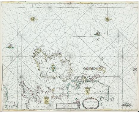
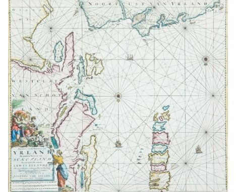
Lot 22
Theunis Jacobsz (1606-1650)A Set of Four Charts of Ireland and the Irish Sea, 1667, including South-east, North-east, North-west and South-west(i) “De Zuyd oost zyde van Yerlandt Van Dubling tot aen t`Eylandt Corkbeg. T`Amsterdam. By Iacob Theunisz op t` water inde Loots-man.”; (ii) “De Noord-oost zyde van Yerlandt van Caap de Hoorn tot aen Hedehde en Als mede hoe`t`van Schotlandt gelegen is. `t Amsterdam. By Theunis Theunisz. Op`t water in de Lootsman.”; (iii) “De Noordwest zyde van Yerlandt Beginninde van Capo de Hoorn tot aen Schynrs, of Slyne-head. T Amsterdam. By Iacob Theunisz op`t water inde Loots-man.”; (iv) “De west custen van Yerlandt Beginninde van Corckbeg tot aen Slynehooft. `t Amsterdam. By Iacob Theunisz op`t water inde Lootsman. Met Privilegie Voor 15 Iaren.” Set of four charts of the Irish coast from the Nieue en Groot Loots-mans Zee-Spiegel of 1696. They have numbers “W 14” to “W 17” in the lower right corner and verso blank. All have the words “Met Privilegie Voor 15 Iaren” added, but in the first three it is in the lower right corner, whereas in the fourth it is at the end of the title. 530 x 430. (4)
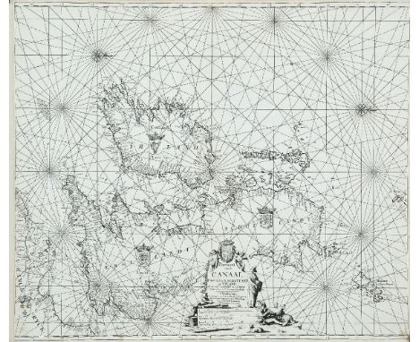
Lot 27
Keulen, Johannes van (c.1654-1715)Bookseller and publisher of Amsterdam, was founder of a family firm which lasted until 1885. His son Gerard van Keulen, grandson Johannes II and great-grandson Gerard Hulst van Keulen improved and updated later charts. His first publication was De Groote Nieuwe Vermeerderde Zee-Atlas Ofte Water-Werelt of 1680, in many languages and running to many editions. His other publication was De Nieuwe Groote Lichtende Zee-Fakkel, of 1681, which is essentially a pilot-guide with more text.A Chart of Ireland and the Irish Sea (1680)“Pascaart vande Canaal Engeland, Schotland en Yrland, Synde vande miswysingh en veel fouten verbetert door veel Ervaerne Stierlieden. T`Amsterdam. By Ioannes van Keulen, Boeckverkooper en Graedboogh maecker aende Nieuwbrug inde gekroonde Lootsman. Met Privilegie voor 15 Iaar.” From De Groote Nieuwe Vermeerdende Zee-Atlas Ofte Water-Werelt (1680). It is oriented with North to the right. Verso blank. 605 x 520.
Lot 28
Johannes van Keulen (c. 1654-1715)A Chart of Ireland and the Irish Sea (1681)“Paskaart van`t Canaal Engelandt, Schotlandt en Yerland Naaukeurig opgestelt en dienstig voor die achter Yrland omkomen. T`Amsterdam, by Iohannis van Keulen, Boekverkooper en Grand Boog-Maaker aan de Nieuwen-brug in de Gekroonde Loots-man. Met Privilegie voor 15 Iaar.” It is in the first state, dating from 1681 from De Zee-Fakkel. It is oriented with north to the left, unusually for Dutch cartographers covering this area, and has a more decorative title cartouche and lighter rhumb lines than the other version [Lot 27]. Verso blank. 580 x 510.
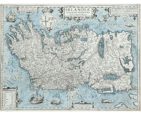
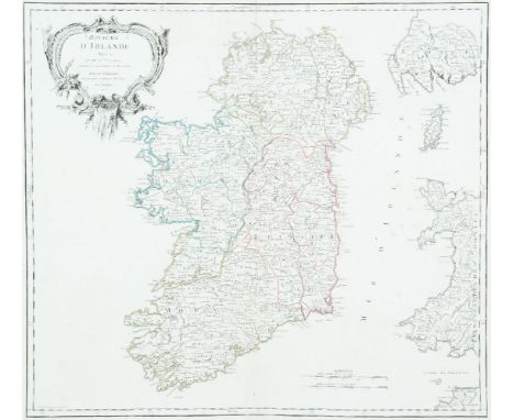
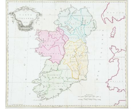
Lot 319
Richard Blome (1635-1705)A Map of IrelandFrom his Britannia, first published in 1673. The maps are based on John Speed. Five Coats of Arms. In this copy, Boyle's Coat of Arms at the top left has been replaced by that of the Earl of Essex. Boyle's arms have been added below the compass rose off Dublin. 390 x 375. Abl 12(ii).
Lot 44
Johannes van Keulan (c. 1654-1715)Chart of the North Coast of Ireland and S-W Scotland Koeman No. 77. There is a boxed 17 in the lower right corner. It occurs in van Keulen's Zee-Fakkel from the first edition (1681) and in some of the editions of the Zee-Atlas from the English edition of 1682. It does not occur in the Zee-Fakkel of 1728 or later, one of the larger charts (VI or VII) being inserted instead.The chart shows the north Irish coast from Larne to Aran Island, and the Scottish coast from the Mull of Galloway to Skye and North Uist. The title in the lower left corner is loosely framed, surmounted by Flora and two hand-maidens, and at their feet is a horned satyr with sheep and goats. There is another female figure alongside the frame. The title reads Pascaart van de Noortcust van Yrland Als meede de Westcust van Schotland En een gedeelte van de Lewys Eylanden. Met al syn Diepten en Droogten Dus van Naukeurig Opgestelt en van Veel Fauten verbeetert, Met Priviligie voor 15 Iaar. T'Amsterdam By Joannes Van Keulen, Boekverkooper aan de Nieuwenbrugh. The scales are below the title and read Duytsche Mylen 15 voor een Graat 9 [= 115 mm.] Engelsche en Fransche Mylen 20 voor een Graat 12 [= 116 mm.] Spaansche Mylen 17 1/2 voor een Graat 11 [= 121 mm.]. There are soundings near Dunluce and in Lough Foyle, but more round the Scottish coast. There are two compass roses showing north at the bottom, and three ships, also scales of latitude along each side of the chart. (585 x 510).
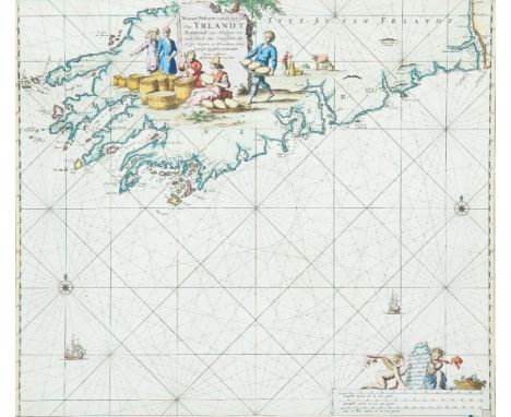
Lot 45
Johannes van Keulan (c. 1654-1715)Chart of the South-West Coast of Ireland Koeman No. 80. There is a boxed 20 in the lower right corner. It occurs in van Keulen's Zee-Fakkel from the first edition (1681) to the last (1802), and in some of the editions of the Zee-Atlas from the English edition of 1682.The chart shows the south-west coast of Ireland, from the mouth of the river Shannon to Waterford. The title is in the top centre in a loose frame, surrounded by a milkmaid milking, one churning, and others carying and packing butter. Two fashionably-dressed men are standing nearby. The title reads Nieuwe Pascaert, van de suyt syde van Yrlandt Beginnende van Blasques tot ande Hoeck van Waterfoort, Met al syn diepten en Droochten Naeu keurigh opgestelt, en van veel fouten verbetert. Met Priviligie voor 15 Iaar. The publisher's imprint is separate, on a tablet held up by cherubs in the lower right corner of the chart, reading 't Amsterdam by Iohannus van Keulen boeck en Zee kaert verkoper an de Nieubrug Inde gekroonde Lootsman. Below this are the scales Duytsche mylen 15 in een graet 13 {= 172 mm.] Spaensche mylen 17 1/2 in een graet 15 [= 172 mm.] Eng. en Fra. mylen 20 in een graet 17 [= 170 mm.]. There are coastal soundings round Kenmare, Bantry, Kinsale and Cork. There are two compass roses showing north at the top, and two ships, also scales of latitude on either side of the chart.
Lot 46
Johannes van Keulen (c. 1654-1715)Chart of Ireland and the Irish Sea Koeman No. 298. It occurs first in van Keulen's Zee-Atlas of 1718 and then in De Nieuwe Groote Lichtende Zee-Fakkel of 1734 and in some subsequent editions.The chart shows all of Ireland and the coast of Great Britain from Land's End to Ayr. In Ireland the Ards peninsula, Island Magee, the tip of Innishowen and Mullet are all shown as islands. The title, in a plain oval frame over Wales, reads Nieuwe Paskaart van Ierland en de West kust van Engeland Vervattende in sig St. Joris en het Verkeerde Kanaal, Gelegt naer de Nieuwste ondervinding van ervaren Zeelieden. The New sea Map of Ireland and the West Coast of England containing St. George and the Channel of Bristol made according the newest experience of Expert Mariners. The publisher's imprint is in a rectangular frame with scroll-like ends, in the top right corner, and reads te Amsterdam by Joannes Van Keulen Boek en Zeekaart verkooper aan de Nieuwen Brug met Privilegie. The scales are in the lower right corner reading Duytsche Mylen van 15 in een Graad 25 [= 184 mm.] Fransche Mylen van 20 in een Graad 33 1/3 [= 184 mm.] Engelsche Mylem van 60 in een Graad 100 [= 184 mm.] Schotse Mylen van 50 in een Graad 40 [= 91 mm.] Ierse Mylen van 48 in een Graad 40 [= 91 mm.]. There are soundings scattered round all the coasts as well as four compass roses showing north at the top and scales of latitude on either side of the chart. (977 x 595 mm.).
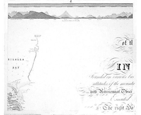
Lot 463A
William BaldMayo, Map of the maritime County Mayo in Ireland.Founded on various bases and trigonometrical operations, exhibiting barometrical altitudes of the mountains, the levels and depths of the bogs and lakes; with Astronomical Observations, Physical Sections and Profiles of the Country; Executed by order of the Grand Jury. The Right Honourable Denis Brown M.P. and Member of the Dublin Society, and Royal Irish Academy, foreman; Commenced in 1809, and terminated in 1817, by William Bald F.R.S.E. Member of the Royal Geographical Society Paris, Member of the Geological Society London, Member of the Royal Irish Academy, Honorary Member of the Wernerian Natural History Society Edinburgh. Engraved by Pierre Tardieu, 1830. overall dimensions when joined. 3.11m x 2.57m average sheet size 620 x 510By William Bald, a massively detailed map of Mayo in 25 sections, each varying slightly in size; a little detail here and there of adjacent counties. Large title cartouche. Extensive table of mountain heights. Lake levels; bog levels and depths. Coastal soundings. Plan of trigonometrical base lines. Scale 1 inches to 1 mile. Published by the Mayo Grand Jury. Some edges frayed and some light foxing otherwise in very good condition. William Bald was born in Burntisland in 1789. He was employed as an apprentice under the celebrated Scottish surveyor, engraver and mapmaker, John Ainslie. Bald made a survey of Harris in 1805 when he was only 16, and was later responsible for surveys of ~Benbecula, south Ulst, Eriskey and Argyll, possibly because the tugged nature of the terrain would have been difficult for Ainslie, then in his 60s. These and other of his surveys were later incorporated into Aaron Arrowsmith's map of Scotland. By the time Bald arrived in Mayo in 1809 as county surveyor, he had been described by his teacher and mentor John Ainslie as a very big man... In the words of John Andrews, no ordinary tribute for a twenty-year-old. Bald's first commitment in Mayo was a Grand Jury map of the county. At the same time, he managed to work for the Bogs Commission on their brief for a survey of the bogs of Ireland. Both surveys were to degree of sophistication and meticulousness which far outstripped anything known in Ireland up to that time. His map of Mayo was unique in its scale and scholarship. The base measurement and triangulation were impeccable. Bald spent 18 years on the Mayo survey and engaged Pierre Tardieu in Paris, the foremost engraver of his day, to bring the map to fruition. This was done very slowly and at great expense, finally reaching the light of day in 1830. Bald was a familiar figure in Castlebar, much admired by some, yet disliked by others who through envy of his great expertise, carped at his efforts; or who, unused to the sheer cost of mapping on such a scale, complained at his lavish use of public money. Bald went on to plan surveys of Clare and Down. He even envisaged a general triangulation of Ireland and a new geological map. He still found time to attend to roads and bridges in his adopted county. The coming of the Ordnance Survey spelled the end of the era of the great land surveyors, Bald among them. In later life, he concentrated on roads, bridges, canals and harbours, and eventually railways. He was a principal adviser in the early deliberations of the Ordnance Survey. William Bald loved Mayo, as can be seen from his Map. The profusion of place names, particularly coastal place names, attests to his love of the Mayo landscape, so like his native Scotland. He was one of the ablest, most hard-working and most creative map-makers ever to practise in Ireland. He died in 1857; he is buried in Highgate Cemetery, London. His wife, Anne, pre-deceased him; she is buried in Straide, Co. Mayo.
Lot 46A
Johannes van Keulen (c. 1654-1715)Chart of the North Coast of Ireland and W. Scotland Koeman No. 244. It occurs first in van Keulen's Zee-Fakkel, Part 2, of 1728 (Dutch edition) as a replacement for chart III, but not in the late editions where chart VI was used instead.The chart shows the north coast of Ireland from the middle of the Ards peninsula to north Sligo and the west coast of Scotland, including the Hebrides and St. Kilda. The Ards peninsula, Island Magee and the tip of Innishowen are all shown as islands. The title, in a plain oval frame over Ireland, reads Nieuwe Paskaart van de West Kust van Schotland, de Lewys Eylanden en de Noord Kust van Yrland, beginnende van C Wrath of de Noordelykste hoek van Schotland tot in het St. Ioris Kanaal. te Amsterdam by Gerard van Keulen Boek en Zeekaart verkooper aan de Nieuwen brugh met Previlegie. The scales are in the lower right corner in a plain rectangular frame and read Duytsche Mylen 15 in een Graad 15 [= 243 mm.] Englisch Leagues 20 for Degree. Lieues de France 20 par Degrez 20 [= 243 mm.] Schotse Mylen van 50 in een Graad 24 1/2 [= 120 mm.] Ierse Mylen van 48 in een Graad 24 [= 122 mm.]. There are scattered soundings round the Irish and Scottish coasts, three compass roses showing north to the right, and scales of latitude along the upper and lower borders. (1010 x 605 mm.).
-
596772 item(s)/page