We found 209236 price guide item(s) matching your search
There are 209236 lots that match your search criteria. Subscribe now to get instant access to the full price guide service.
Click here to subscribe- List
- Grid
-
209236 item(s)/page


Lot 1438
A rare Ming Dynasty porcelain pillow vase with high shoulders and tapering body and flared neck, painted in underglaze blue, the front panel with vase outline, painted with the `three friends`; bamboo, pine and prunus, the sides moulded in the form of two ruyi heads, each painted with a phoenix, reserved on a chrysanthemum and foliage background, height 33cm.
![World ([World and Horological Diagrams]), Ritter, Speculum Solis…, [1607]. 13.3 x 11”. (BW) A rare and extremely](http://lot-images.atgmedia.com/SR/36385/2862480/12-2012510161438_468x382.jpg)
Lot 12
World ([World and Horological Diagrams]), Ritter, Speculum Solis…, [1607]. 13.3 x 11”. (BW) A rare and extremely unusual map shows the world projected from the North Pole as if it were the table of a sundial. The landmasses are drawn to scale in proportion to their distance from the pole. The result is a very distorted, though mathematically correct, projection. Ten horological diagrams surround the central map and all are enclosed in a decorative border. The plate was designed for Ritter`s first edition of the Speculum Solis in 1607, and is a synopsis of all the plates that appear in his later editions. Ref: cf Shirley no.270. Watermarked paper with a few minute tears that have been professionally closed on verso. Also professionally remargined. (A)

Lot 150
Eastern United States, Civil War (Distance Maps. Map of the Atlantic States, Showing 50 Mile Distances from Washington. Map of the Battle Ground [at Manassas], Showing 5 Mile Distances from Washington. Map of Fortress Monroe, Showing 1 Mile Distances from the Fortress.), Prang, 1861. 12.5 x 21.8”. (PC) This rare Civil War broadside includes 5 maps and statistical information from the 1860 census. This sheet was designed to illustrate the theater of the war that was engulfing the nation and to highlight the recent major battlefields. The largest map, Map of the Atlantic States, Showing 50 Mile Distances from Washington, is centered on Washington DC and shows 50 mile distances in concentric circles from the capital. Existing and proposed railroads are noted, along with forts. The smaller maps at top and bottom include Map of the Battle Ground [at Manassas], Showing 5 Mile Distances from Washington, Map of Fortress Monroe, Showing 1 Mile Distances from the Fortress, Position of Forces at Bull Run and Fortress Monroe. This is one of Prang’s earliest war maps, issued just months after the start of the war. It was distributed by J. Haven, Prang’s agent in New England. Louis Prang, a lithographer in Boston, became well-known for his Civil War maps. Prang used a clever marketing program to promote his maps. They were distributed at newsstands or as a premium for newspaper subscribers and accompanied by red and blue colored pencils with which the user could plot the progress of the armies. Due to their ephemeral nature, these maps are quite rare today especially in good condition. There are no listings of this map being for sale in the last 30 years. Ref: Stephenson no.15; Rumsey no.5440.000. There are two tiny holes in the map image and a number of edge tears, mostly at top that have been closed on verso with archival tape. The map is lightly toned, has an extraneous crease that does not distract, and a few small stains. (B)

Lot 162
Mid-Atlantic United States (A Map of Pennsylvania Delaware New Jersey & Maryland, with the Parts Adjacent), Thackara, The History of Pennsylvania, Boston, [1798]. 15.3 x 12.3”. (BW) This rare map was engraved by James Thackara and published in Robert Proud`s The History of Pennsylvania. The map covers an area from southern New York to Central Virginia and displays rudimentary topographical detail of the Allegheny Mountains and Chesapeake Bay as well as towns, settlements, roads and rivers. Delaware is also labeled as Territories of Pennsylvania. A simple compass rose adorns the Atlantic Ocean. Ref: Wheat & Brun no.312. Issued folding with a few tiny fold separations that have been closed with archival tape on verso, a very small wormhole at lower right and some scattered spots in the image. There is a binding trim and minor insertion tear at lower right that has been repaired with old paper. (B)

Lot 206
Southwestern United States (Report of the Exploring Expedition from Santa Fe, New Mexico, to the Junction of the Green Rivers of the Great Colorado of the West, in 1859…), Macomb, Washington D.C., 1876. 9.5 x 12”. (PC) This important report was produced in 1860 but not issued until 1876 due to the Civil War. Included is the very rare Map of Explorations and Surveys in New Mexico and Utah… (34 x 28.5"), which is considered by Wheat to be a landmark in the mapping of the region and "one of the most beautiful maps every published by the Army." According to Wheat there are several reasons for its importance. First, it is the first to show a trail to the junction of the Green and Grand Rivers. Second, he praises the map for its depiction of numerous routes of other explorers. Finally, it demonstrates the culmination of the process developed by Egloffstein to convey the idea of altitude. The process used a combination of extremely fine lines and applying acid to the plate for varying times, thus giving the map a remarkable 3-dimensional realism unmatched in the period. It is also the first to correctly establish the relationship between the San Juan and Colorado Rivers. The map covers Arizona, Utah, New Mexico and about 30% of Colorado. This highly sought after report is complete with eleven black and white engravings and eleven chromolithograph prints, and also features "Descriptions of the Cretaceous fossils collected on the San Juan Exploring Expedition under Capt. J. N. Macomb, U.S. Engineers." by F. B. Meek. 4to. Complete. Hardbound in brown cloth with gilt title on spine. Ref: Wheat (TMW) no.983. There are a number of fold separations and splits at fold intersections, some of which have been repaired on verso with archival material, including a clean 5" fold separation crossing the title that has not been closed. There is some light toning along folds, minor offsetting, and a few small spots. Text and plates are very good with some light toning and occasional small spots. The covers and spine are worn with the front cover loose and almost detached. The binding is almost perished with some pages separated from text block. (B)

Lot 217
Berkeley, California (Map of Berkeley and Vicinity), 1912. 22.8 x 23”. (PC) This is a rare single-sided real estate promotional map of the City of Berkeley and surrounding areas issued by Charles Green on behalf of the Newell-Murdoch Company, Real Estate. Key routes, car lines and S.P. lines (presumably Southern Pacific) are highlighted in different colors with Thousand Oaks, Fairmont Park, Arlington Heights, Northbrae, and Regents Park developments north of the city highlighted in green. The map focuses on land tracts (all named) and street layouts with indices to street names and fire alarm boxes given on the left side of the sheet. Important buildings, schools and fire houses are shown (some named in red) as is the University of California campus as it existed in 1912. An attractive map of this well known Bay Area city. Issued folding with some minor soiling and pencil notations in the image and in the bottom margin. (+B)

Lot 222
Colorado Springs, Colorado (Birds Eye View of Colorado Springs and Vicinity), Anon., ca. 1900. 17 x 24”. (BW) This rare, anonymous promotional map of Colorado Springs shows a developing city with an impressive view of the Front Range in the background. Colorado Springs was founded in 1871 by William Palmer, a former Civil War General. Palmer was a surveyor for the Kansas Pacific railroad and secured legislation and funding for the Denver & Rio Grande railroad. Palmer thought this area was ideal for a town, and announced Colorado Springs as the route`s first destination out of Denver. As a result of the new infrastructure and the Pike`s Peak gold rush, the city became one of the most popular tourist destinations in the west. Printed on thin, banknote style paper. There are a few short splits at fold intersections and a number of small fold separations, some of which have been repaired on verso with archival tape. (B)

Lot 223
Connecticut (Connecticut), Pease, New York, ca. 1833. 14.3 x 10.8”. (BW) This rare wood-engraved map of Connecticut is surrounded by a decorative border of the 24 state seals that were in existence at the time. Arkansas was next in line to achieve statehood in 1836 and the map reports population data as of the 1830 census, putting the date of this map somewhere in between. The map displays basic detail of towns, cities and counties as well as rivers, lakes and mountains. This unusual map was bound into an annual run of the "Philadelphia Mirror" from July 1836 to July 1837 (56 issues). There are a few small spots in the border, some minor extraneous creasing, and a few archivally repaired tears in the blank margins that just enter map border. (B)
![Washington, D.C. (Plan of the City of Washington), Good, The Literary Magazine and British Review, London, [1793]. 10.5 x 9.5](http://lot-images.atgmedia.com/SR/36385/2862480/225-2012510162215_468x382.jpg)
Lot 225
Washington, D.C. (Plan of the City of Washington), Good, The Literary Magazine and British Review, London, [1793]. 10.5 x 9.5”. (BW) This rare map of Washington DC is based on the small Thackara & Vallance plan produced in March 1792 for `The Universal Asylum And Columbian Magazine`, which is considered the first printed plan of Washington. This British version of the map is chronologically seventh, published a mere 10 months later. The map itself shows a few major buildings including the Capitol and the Presidents House, while others are simply outlined. The proposed landscape design for the Mall is shown with considerably more detail. The rudimentary eagle and shield surrounding the title is the only apparent difference to the Thackara & Vallance map. The map is bound into The Literary Magazine and British Review published in January 1793. This monthly periodical includes a 3-page section discussing the Washington Plan immediately following the map (pp. 49-51). Published by J. Good, Bond Street. 479 pp., hardbound, 8vo, contemporary quarter calf over marbled boards. Ref: Jolly LITB-4; Phillips (M) p. 1004 The map has some light offsetting and a tiny binding tear away from the image. Text has some light scattered foxing and a small damp stain in the first few pages along with a few ink notations. Covers are worn and bumped and the hinges are starting. (+B)

Lot 232
Southern Florida, Bahamas, Cuba (A Chart of the Gulf of Florida or New Bahama Channel, Commonly Called the Gulf Passage…), Faden, London, 1794. 29 x 23”. (HC) This chart was completed by Charles Roberts, Master of the Royal Navy, and is based on the work of George Gauld, a Scottish surveyor. Gauld was assigned by British Admiralty to chart the waters off the Gulf Coast from Louisiana to the Bahamas. He arrived in the Florida area in 1764 on the English ship Tartar, along with John Harrison’s son. William Harrison was on board to test his father`s clock Number Four, which was designed to determine longitude at sea. Although Harrison returned to England soon after arriving in Barbados, his longitude measurements were determined to be accurate to two minutes, or two miles. This data aided Gauld in creating extremely accurate charts. Realizing the importance of his work, Gauld began sharing manuscript charts of his early work with scientific societies in America. The Revolutionary War forced Gauld to suspend his work due to attacks by American privateers, and he was taken prisoner in 1781 and repatriated to England, where he died. This rare sea chart depicts southern Florida, the Keys, the Bahamas, and the northern coast of Cuba. Extensive detail of soundings, shoals, navigational hazards, safe anchorages, and wind and water currents is shown. Seven coastal views are depicted in Cuba, and a small inset shows enlarged detail of the islands from Nassau to Booby Rocks. A table with the longitudes and latitudes of various locations fills the top right corner. This map was published by William Faden, who published many of Gauld`s charts. Original outline color with toning, minor offsetting, and light scattered foxing at top. There is a clean centerfold separation that enters 2.5" into map at top, a tear that enters 1/2" into map at top of the cartouche, and several small chips and tears in blank margins, not affecting map. (B)

Lot 272
New Hampshire (New-Hampshire), Lucas, A General Atlas…, Baltimore, ca. 1823. 9 x 12”. (HC) This rare map of New Hampshire is divided into six counties and numerous townships, including an area noted as "Ungranted Land." County lines are current for 1821, just prior to the organization of Merrimack in 1823. There is good detail of roads, lakes, rivers, and mountains. Lucas` General Atlas is known as one of the finest general atlases produced in the U.S. at the time, due to the high quality paper, superior engraving quality, and attractive coloring style. Engraved by B. T. Welch. Ref: Phillips (Atlases) no.742-51. Lovely original color on watermarked paper with a couple of insignificant spots. (A)

Lot 316
Vermont (Vermont), Pease, New York, ca. 1833. 10.8 x 14.3”. (BW) This rare wood-engraved map of Vermont is surrounded by an elaborate decorative border of the 24 state seals that were in existence at the time. Arkansas was next in line to achieve statehood in 1836 and the map reports population data as of the 1830 census, putting the date of this map somewhere in between. The map displays basic detail of towns, cities and counties as well as rivers, lakes and mountain ranges. There is a brief note to the right of the map that describes elections, trade and geography. The state seal of Maryland at lower right is not labeled. This unusual map was bound into an annual run of the "Philadelphia Mirror" from July 1836 to July 1837 (56 issues). The map is clean and bright with a printer`s crease at upper right and some very minor extraneous creasing. (A)

Lot 344
Gulf of Mexico and Caribbean (Kaart van het Middelste deel van America), Dampier, Nieuwe Reystogt Rondom de Werrel, London, [1698]. 11.3 x 6.3”. (BW) This is from de Hondt`s rare Dutch edition of William Dampier’s voyages. The English edition`s map, titled "A Map of the Middle Part of America," is identical in its depiction; this edition is re-engraved to use Dutch names. This chart shows part of the route of William Dampier`s first circumnavigation voyage in the 1680s with his passage across the isthmus of Panama. The map covers the area of northern South America through Central America into what is now the southern United States with Mary-Land, Virginie, Caroline, Floride, and N. Mexique named. There is an inset map detailing the Cape Verde Islands with the route of exploration delineated. Nice impression with a few minor stains and light toning in the blank margins. Issued folding. (+B)

Lot 368
The Grenadines, Bequia (The Island of Becouya…), Norie, London, 1827. 18.5 x 12.5”. (HC) A lovely and rare navigational chart of the island of Bequia, just south of St. Vincent in the Grenadines. The rocky coastline and the topography are well depicted in addition to the few roads and villages on the island. A large inset shows Admiralty Bay, as surveyed by Captain Dovers, with numerous soundings and navigational hazards. The inset includes details such as "the only windmill," a battery of three guns, a burial ground, and "negro houses." Bequia and the Grenadine islands were ceded to Britain in the Treaty of Paris in 1763, and the islands remained under British control until their independence in 1979. Light soiling with a couple of minor abrasions and minute worm holes, and short fold separations that have been closed on verso with archival materials. There are three tears that enter about 1/2" into map at top that have also been closed with archival materials. Narrow right and bottom margin. (B)

Lot 377
Northern South America (Mapa de la Provincia, y Missiones de la Compania de IHS del Nuevo Reyno de Granada), El Orinoco Ilustrado y Defendido, ca. 1741. 16 x 11.1”. (HC) This rare map of the northern tip of South America is centered on the Orinoco River, extending from Cartagena, Colombia in the west to present-day French Guiana in the east. The mythical Laguna de Parima is depicted along the equator. A legend identifies cities and towns, Jesuit schools and missions, and locations where missionaries died. An inset at bottom right depicts part of the Amazon River. A decorative cartouche at bottom dedicates the map to Francisco de Miranda. Drawn by Padre Joseph Gumilla, engraved by Paulus Minguet, and published by Manuel Fernandez. Issued folding, now pressed on watermarked paper with a few tiny fold separations that have been repaired with archival materials. There is an archivally repaired tear that enters 2.5" into map image at right. The map has been remargined at right and left with part of left-hand border in facsimile. (B)

Lot 387
Brazil (Pas-kaart, Van de Zee-Kusten van, Brazilia, Tusschen, C.S. Thome en I.S. Catharina…), Keulen, Amsterdam, ca. 1682. 23 x 20”. (HC) Rare sea chart of the Brazilian coast from Illia S. Catharina to Cabo S. Thome, along with an inset of Rio Ianeiro (Rio de Janeiro and Guanabara Bay). The decorative chart is filled with rhumb lines, two compass roses, and a sailing ship. The title cartouche is flanked by natives trading goods with a European merchant, and a tent in the background. A fine impression with attractive color. There are a few faint spots and a couple of tiny holes that have been archivally repaired. There are a few tiny tears, a small damp stain at top, and some archivally repaired chips, all confined to blank margins. (+B)

Lot 393
Eastern Brazil (Capitaniae de Cirii, et Parnambuco), Jansson, Atlas Novus, Amsterdam, ca. 1657. 21.5 x 17.5”. (HC) This rare chart of the Captaincies of Ceara and Pernambuco extends from the Rio Formosa to the Rio Estremo and is centered on the Rio de San Francisco. Much information is derived from maps drawn for the Dutch West Indies Company during its bid to rest control of the region from the Portuguese. North is oriented to the right of the chart by a compass rose. It is finely adorned with two cartouches and sailing ships. Lovely original color with light offsetting, two 1/2" centerfold separations towards the top, and a couple of minute cracks caused by the oxidation of the green pigment. There is a tear that just enters map border at bottom that has been closed with archival materials. (+B)

Lot 394
Salvador, Brazil (Aenwysinge van de Stadt Salvador, ende de Baya de Todos Los Santtos), Hondius, Amsterdam, ca. 1624. 16.5 x 11.5”. (HC) This rare map of Salvador and Baia de Todos os Santos (Bay of Saints) ) is a very early depiction of the Dutch attack and capture of the city of Salvador in May 1624. Salvador, then the capital of Brazil, was a strategic port under Portuguese control. The Dutch, determined to seize control of Brazil, formed the West India Company in 1621 and sent a large expedition to Brazil. On May 8, 1624, the Dutch fleet under the command of Admiral Jacob Willekens and Vice Admiral Pieter Heyn arrived in Salvador and attacked the city. The Dutch succeeded in capturing the city, although the Portuguese regained control less than a year later. This map depicts the city of Salvador and its fortifications, with the 26 Dutch ships advancing on the city. The remainder of the coastline is sparsely engraved with a few small towns, trees, and hills. The map is oriented with north to the left and includes an inset bird`s-eye plan of Salvador, with 16 locations identified in a key in the title cartouche. A later edition of the map shows fewer ships attacking the city, perhaps illustrating a later Dutch attack. The imprint at lower right credits Henricus Hondius in The Hague. It is unclear if this is the well-known Amsterdam publisher or the lesser-known engraver and printer from Delft who worked during the same period. Light soiling with a few tiny tears along centerfold that have been repaired with archival materials. There is a small hole in right blank margin that has been closed on verso with old paper, and a tiny worm hole near I. Pycco. (+B)
![London, England ([Lot of 2 - London Street Views]), Tallis, Tallis`s London Street Views, London, ca. 1840. 16.5 x 4.8”](http://lot-images.atgmedia.com/SR/36385/2862480/450-2012510163917_468x382.jpg)
Lot 450
London, England ([Lot of 2 - London Street Views]), Tallis, Tallis`s London Street Views, London, ca. 1840. 16.5 x 4.8”. (BW) These two rare plans depict the building views from street level along Bishopsgate Street Without and Newington Causeway. Bishopsgate Street, one of the original Roman roads in the city of London, derived its name from an ancient gate in the city walls adorned with statues of bishops of London. Newington Causeway is located in central London. Each plan includes views of the buildings on both sides of the street, with many proprietors named, in addition to a bird`s-eye plan of the area and a vignette with a close-up of one merchant`s building. Light offsetting with some light creasing and a few small binding holes along centerfold. (+B)

Lot 475
Scotland (Plan Shewing the Course of the Roman Wall Called Grime`s Dyke Raised along the Isthmus between the Forth and the Clyde in the Reign of Antoninus Pius…), Basire, Military Antiquities of the Romans in North Britain, London, 1793. 63 x 16.5”. (BW) This is a rare and detailed map and plan of Antonine`s Wall, which was constructed by the Romans in 142 AD and represented the northernmost point of the Holy Roman Empire. Construction was ordered by Emperor Antoninus Pius, and the resulting wall stretched 63 miles east to west and was located approximately 70 miles to the north of the better known Hadrian`s wall. This map was based upon a survey completed in 1755. The top part of the engraving is a very detailed 6" strip map of the wall from The River Clyde to the Frith of Forth in the East. Below the map is a series of 10 detailed plans of forts and castles along the wall including Duntocher Fort, New Kirkpatrick Fort and Rough Castle. The bottom section of the sheet has 7 profile views of the wall. Engraved by James Basire and published by the Society of Antiquaries of London in William Roy`s classic work on the Roman military conquest of Scotland. Printed on two joined sheets, as issued. Printed on thick paper and folded. There is scattered minor foxing and some extraneous creasing near the folds. (B)

Lot 528
Atlas, France (Cosmographiae Partis II, Liber III, de Gallia…), Merula, Amsterdam, 1636. 3.3 x 5.3”. (BW) This rare miniature geography book of France is complete with 25 folding maps and about a dozen genealogical charts. The maps include Gallia, Picardia, Champaigne, Brie, Lionnois, Normandia, Languedoc, Provence, and Burgundia Ducatus. These were originally engraved by Jodocus Hondius and Pieter van den Keere for Bertius` Tabularum geographicarum... Hardbound in vellum with red leather label with gilt title on spine. 467 pp, title page, list of plates, text, maps and charts. Merula, a Dutch jurist, was appointed to the chair of history at the University of Leyden in 1592. In addition to this geography he also published folio editions, wrote many treatises on laws and history and is also known for his geological studies. This edition was published by Willem Blaeu from Amsterdam. Maps are in near fine to very good condition with light toning, offsetting, and occasional foxing. Text is lightly toned with occasional foxing. Covers and spine are worn and stained. Hinges are starting and endpapers have a few small worm tracks. (+B)

Lot 614
Switzerland, Geology (Livret-Guide Geologique Dans Le Jura et les Alpes de la Suisse…), 1894. 5.8 x 8.3”. (PC) This rare geological excursion guide was issued in conjunction with the International Geological Congress of 1894, which met in Zurich, Switzerland. The volume contains 2 maps and 10 profiles and cross sections of the Jura mountains and the Alps. In addition to the maps and profiles are numerous other illustrations and tables included in the text, describing particular excursions and geologic features. 307 pp., hardbound in brown cloth covered boards with gilt title and stamp on front cover. Maps are clean and bright and are generally very good to fine. The geologic map has a few short splits at fold intersections. Plates were originally housed in pockets attached to the front and back covers, but the pockets are now perished. Text is generally good with some light toning and brittle endpapers. The hinge is starting and the covers are somewhat bumped and worn. (+B)

Lot 628
Russia (Tabula Russiae ... M.DC.XIIII), Blaeu, Amsterdam, ca. 1644. 21.6 x 16.8”. (HC) This is Blaeu`s version of Hessel Gerritsz` rare and significant map of Russia, which he compiled from manuscripts brought back by Isaac Massa. The map covers the European part of the Russian Empire extending from Poland to the steppes of Tartary, and from the Mourmanskoy More (Barents Sea) to the Black and Caspian Seas. The large inset plan of Moscow is attributed to the Crown Prince Fydor Gudonov. The map is richly decorated with a large title cartouche, sailing ships, a compass rose, three Russian gentlemen, and an inset view of Archangel Sckagoroda. French text on verso. A good impression and attractive color with light toning along centerfold and a centerfold separation that enters 2" into map at bottom that has been closed on verso with old paper. There are minor damp stains and two archivally repaired tears in blank margins, not affecting map. (+B)

Lot 685
Crete (Candia met de Omleggende Eylanden), Doncker, Nieuw Groot Stuurmans Straets-Boeck, Amsterdam, ca. 1664. 20.2 x 15.5”. (HC) This very rare sea chart features Crete and surrounding islands. It is decorated with a strapwork and garland style title cartouche, three different scales of miles, two compass roses with north oriented to the right, and is filled with rhumb lines. There is a tiny hole to the right of Crete, a few faint spots, and some very light marginal soiling. (+B)
![India & Sri Lanka (Tabula Asiae X), Gastaldi, La Geografia, Venice, [1548]. 7 x 5.3”. (BW) Rare little Ptolemaic ma](http://lot-images.atgmedia.com/SR/36385/2862480/788-201251017741_468x382.jpg)
Lot 788
India & Sri Lanka (Tabula Asiae X), Gastaldi, La Geografia, Venice, [1548]. 7 x 5.3”. (BW) Rare little Ptolemaic map centered on India with recognizable river systems, but completely lacking the sub-continental shape of the landmass. The top of a large Taprobanae Pars (Sri Lanka) appears at bottom. The map is presented on a trapezoidal projection with rope-like mountain ranges and strange creatures in the border, one of them being a bird with the face of a man. Italian text on verso. Ref: Karrow no.30/53; Mickwitz & Miekkavaara (Nordenskiold) II no.214-49. Printer`s ink residue on the plate and light toning along centerfold. (+B)
![Botanicals ([Lot of 3 - Mushrooms]), Icones Farlowianae: Illustrations of the Larger Fungi of Eastern North America, [1929].](http://lot-images.atgmedia.com/SR/36385/2862480/852-201251017129_468x382.jpg)
Lot 852
Botanicals ([Lot of 3 - Mushrooms]), Icones Farlowianae: Illustrations of the Larger Fungi of Eastern North America, [1929]. 11.3 x 14.3”. (PC) These superb chromolithographs are among the most beautiful American mushroom plates ever made. There were only 500 sets printed and they are exceedingly rare. William Gilson Farlow, a professor of botany at Harvard, collected the specimens illustrated between 1889 and 1911. His intention was to publish a guide for their identification. He employed two great artists, Joseph Bridgham and Louis Krieger, to prepare the illustrations and had the plates printed by the Boston Heliotype Printing Co. Unpublished at the time of Farlow`s death in 1919, the work was continued by Farlow`s student, Edward Angus Burt, and finally published in 1929. This set includes an unnamed plate (one of five new species that was added by Burt), Cantharellus Floccosus and Lactarius Indigo. Mild toning at edges. (A)
![Medieval Manuscripts ([Illuminated Leaf]), Anon., ca. 1460. 4.8 x 6.3”. (HC) A very pretty leaf from a Parisian Book of](http://lot-images.atgmedia.com/SR/36385/2862480/877-2012510171344_468x382.jpg)
Lot 877
Medieval Manuscripts ([Illuminated Leaf]), Anon., ca. 1460. 4.8 x 6.3”. (HC) A very pretty leaf from a Parisian Book of Hours, written on a fine sheet of buttery, white vellum in black ink. Both sides of the leaf are decorated with initials and line fillers illuminated in red, blue, white and burnished gold leaf, as well as decorative panels painted with gold leaves on hairline stems with colorful flowers and fruits. Among the smaller initials are three X`s, which are quite rare, and three of the line fillers are flowers. The text on recto begins: Agnus dei qui tollis peccata mundi exaudi nos domine. Agnus dei qui tollis peccata mu[n]di miserere nobis. Xriste audi nos. Xriste exaudi nos. Kyrie eleison. Xriste eleison. This translates as: Lamb of God that takest away the sins of the world, hear us graciously, O Lord. Lamb of God that takest away the sins of the world, have mercy upon us. Christ, hear us. Christ, graciously hear us. Lord, have mercy upon us. Christ, have mercy upon us. Marginal soiling and one minute worm hole only visible when held to light. (A)

Lot 678
[Titanic]. Lloyd`s Register of British and Foreign Shipping. United with the Underwriters` Registry for Iron Vessels in 1885, from 1st July 1912, to the 30th June 1913, vol. 1 - Steamers, Sailing Vessels, and Owners, published 1912, half-title and preliminary leaves sl. creased, three parts with supplement to the first part, some printing in red, abbreviations and table of equivalents pasted to front and rear pastedowns, some spotting and occ. soiling and age creasing, lacks conjugate leaf before half-title (blank?), orig. morocco gilt, wear to spine and extremities, joints cracked, thick 4to. This is the only edition of Lloyd`s Register to list RMS Titanic, giving tabular details of number in book, official number, code letters, steamer`s name, material, rig, &c., master (E.J. Smith), number of decks (`5 dks amidships, 7 dks in No. 1 hold, Elec. light Ref. Mchy. 6 dks in other holds, Sub. Sig. Wireless`), registered tonnage, particulars of classification, built date, by whom and where, owners, registered dimensions, deck erections &c., port of registry, flag, and engines. This copy also notes in black print capital letters adjacent to the name Titanic `(Struck iceberg and foundered 4, 12)`. The volume also lists RMS Carpathia with its Captain A.H. Rostron, rescuers of survivors from RMS Titanic. Rare. (1)

Lot 700
*Pears (Charles, after). Southend and East Coast, a rare original early poster for the London Underground Railway dated 1925, depicting Thames Barge under full sail off the Essex coast, full-colour lithograph, unmounted, shows some age-wear foxing and loss to outer edge, 40 x 30in (100 x 75cm) (1)
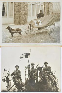
Lot 752
*World War I. Cavalry and Dogs at War. An unusual group of press and other photographs from Agence Rol and others, included rare images marked `Passed by the Press Bureau for transmission abroad`, many with inscriptions verso, including some later period photographs of a visit to Nice and Berlin in 1935 of the German Army Riding Academy, other photographs of equestrian skills, heroic dogs of the battlefield and more of similar interest with some press cuttings, approx. 60 images contained in a folder (1)

Lot 760
*World War I. Small arms in use. A technically interesting collection of French official and agency photographs of small arms used for trench warfare, anti-aircraft and balloon work and similar requirements, some rare and fine images with officers and soldiers in attendance, with an armistace display of captured German weapons, front-line and trench scenes, together with a similar collection of heavy artillery images, shell manufacture, tanks and others of similar military interest, approx. 65 images, contained in a folder (1)

Lot 864
*WWI Tank Mk I. A very rare and large cast-iron gate memorial plaque inscribed `William Foster & Co. Lincoln` c. 1918, of heavy raised relief design cut-out format in the distinctive shape of the first `Tank` utilised by the British Army on the Somme in 1917 & 1918, excellent riveted detailing to armour-plated construction with side-mounted gun-turret nacelle and crawler-track outline, possibly a unique memento of this ground-breaking invention designed to break the deadlock of trench warfare on the Western Front and revolutionise military strategy thereafter, 39 x 14in (36 x 100cm) (1)

Lot 29
*Kawasaki Ki-45 `Toryn`. A fine collection of rare images of this aircraft in service, then later of a captured example under test in the United States of America, most inscribed or labelled verso, including aircraft portraits, ground and air, in Japanese service with a variety of unit markings, approx. 60 images contained in a folder (approx. 60)


Lot 35
*Nakajima. A rare archive of press, publicity and private photographs, many copied after the original and inscribed verso, aircraft types include Ki-44 `Shoki/Tojo`, Ki-49 Donryu/`Helen`, Ki-84 Hayatey/`Frank`, Ki-87 & Ki-115 Tsarugi, and others, many inscribed verso, approx. 150 images, contained in three folders (3)

Lot 48
*Cattoi, Observer to Natale Palli, Royal Italian Air Force 1915-1917. A rare, perhaps unique, collection of private photographs of this successful team who flew over the Italian /Austrian front during the First World War, flying Ansaldo, Farman, Italian-built Nieuport, Savoia, Cant and Caproni types, some aircraft portraits including Nieuport Ni. 1765, air-to-air of an Ansaldo reconnaissance aircraft, crashed Caproni, an airship shed and image taken at dawn from an airship, various flying boats, airfields, pilots and other air and ground crews, motor transport, troops going to the front, wrecked fortifications, Caproni Ca. 1144 push-pull trimotor and later post-war Savoia aircraft and others of similar interest, including Italian ace Baracca`s flight to Trento 19-6-1921, approx. 80 images contained in a folder (approx. 80)

Lot 53
*Fieseler-Flugzeugbau G.M.B.H. A rare original Fieseler `Storch` manufacturer`s brochure, published in French, Copy No. 329 containing 19 pages of type-written aircraft specification descriptions with tables of performance and graph, also with a fold-out die-line three view drawing of the Fi 156B and five fold-out plates with ten original company publicity photographs including aircraft portraits, cockpit and engine installation details, this aircraft with wings folded for transport and others of similar interest, orig. covers, folio, together with a collection of photographs, press cuttings, advertisements and other related documentation contained in a folder (1)

Lot 55
*German Civil Aviation 1919-1939. A collection of photographs, specifications and press-cuttings relating to many aircraft types built during this period, including many manufacturer`s images, also those from the studios of C.W. Erick Meyer of Dresden and Zander & Lalisch, aircraft types include Arado with leaflet for the SCII, the Albatros L83 and others, the BMW M20 high wing monoplane, Bucker, the Caspar U1 float-plane, Dietrich-Gobiet, Dornier `Wal`, a 13-page type-written descriptive pamphlet of the `Wal` flying boat, Dornier Do.23 and others, the Heinkel 118 and further types, Junkers aircraft include the G.38, Ju.52, 86 and 89, various types of Klemm, a Lufthansa leaflet, rare images of the Mercedes-Daimler L-20, Werft-Stralsund and various Udet-Fleugzeingbau types and other historic and interesting photographs, many with manufacturer`s and photographer`s stamps verso, together with inscriptions describing the subject aircraft place and date, approx. 110 images contained in a modern ring binder (approx. 110)

Lot 70
*Rohrbach Metal Aeroplan Co. A/S. A rare collection of original photographs and documentation, comprising of an album of twelve images of the construction of the Dornier Do. Rs III each image stamped `Comissione Aeronautica Interalieta di Controllo in Germania Sezione Italiana`, Quartier Generale, a catalogue illustrating aircraft types built by Rohrbach and subsidiaries including the Zeppelin-Werken Staaken 1000 PS four-engined airliner, various other Ro. aircraft, a leaflet and orignal letter to Societ? Italiano Caproni from Rohrbach dated 18th December 1925 and a quantity of official and private images of Rohrbach aircraft, land and float planes, approx. 30 images with documentation contained in a folder (approx. 30)


Lot 242
*Flying Log Books. Spiller (Alec John). A rare group of pilot`s flying log books which trace the career of this highly succesful A.T.A., service and private pilot who flew approximately 100 different aircraft types both military and civil, and post war flew in the King`s Cup and other races. Log Book No. 1. First flight on 2.2.36 in de Havilland DH60 G-ABTS, at Sywell for 15 minutes with Mr Hayward as instructor, other instructors included a Flt. Lt. Wilson and Capt. I.W.C. Mackenzie, went solo after 6 hrs 30 mins. Training continues with the Northamptonshire Aero Club flying the DH60 and Douglas engined Drone G-AEJH, on 20.4.38 took DH60 G-AAHG to friends wedding, on 18.6.39 flew at Brooklands for the 4 Club Competition with S/Ldr. Shute with only 78 hrs to his credit, records many flights for tea with friends, on 12.3.41 takes test for the A.T.A. in Tiger Moth R4907, extensive map reading, forced landing and other practice with A.T.A. pilot Flight Officer Pickup, numerous cross-country exercises, converts to `Anson` and `Oxford` twin-engine types, based at White Waltham, first flight in `Hurricane` and `Lysander` aircraft, then the `Fulmar`, `Battle` and `Defiant`, first `Spitfire` delivery with AB789 from Ringway to White Waltham on 30.8.41 then picked up `Hurricane` BE112 and flew to Harwarden, numerous deliveries safely made, 300 hrs passed on 28.1.42. Log Book No. 2. Apparently concurrent with No. 1, i.e. dated April 1941-Sept. 1944, inside rear cover lists 75 different types flown including the Armstrong Whitworth `Albemarle`, Consolidated `Liberator`, Blackburn `Botha`, Bell `Aircobra`, Short `Scion` and `Sunderland`, the Handley-Page `Halifax` and others, a colossal variety of single and multi-engined types delivered to various units for disposal or other purposes including Gloster `Gladiator` H2267 from Cambridge to Little Rissington on 3.3.44 and Fairey `Swordfish` V4621 from Inskip to Worthy Down on 6.8.44, A.T.A., H.Q., Accidents Committee certificate on 17.8.44 records that flying `Ventura; JT888 the `pilot`s foot slipped off the rudder pedal and became jammed`, by this time Spiller was flying with the No. 6 Ferry Pool, by Sept. 1944 perhaps 50 aircraft types flown, in June 1943 19 types flown in the month after 391 deliveries. Log Book No. 3. Opened October 1st 1944, delivery flight of Avro `Lancaster` HG189 from Castle Bromwich to Elsham Wold, other types flown during month include Short `Stirling`, Bristol `Beaufighter` Consolidated `Catalina` and Fairey `Baracuda` No. 6, Ferry Pool activities continue, during December 1944 seventeen types, including Boeing B-17 flown, by January 1945 85 hours flown, now most being 4-engined types and flying boats, March 1945 particularly busy - 4 sorties on 28/3 including `Anson`, `Beaufighter` and `Spitfire`, end of WWII not recorded as collections and deliveries continue, June 1945 total hours now 1032 first deliveries of the Avro `Lincoln` recorded, Fairchild `hack` aircraft still in use, October 2nd 1945 records delivery of `Albemarle` 2006 to Ratcliffe and last A.T.A. flight on 20.10.45 in Fairchild FK177, on Jan. 11th 1946 Spiller joins Shell in Ecuador flying Budd, Ford and Grumman aircraft, intensive flying over next few months, in June 1947 rejoins Ferry unit delivering `Mosquito` and `Spitfire` aircraft in Italy and Turkey, February 1947 with the Caribbean Petrolcum Company, Venezuela flying Lockheed and `Sea Otter` aircraft. Log Book No. 4. Opened 1.12.48 flying Lockheed 12A YV-P-AEL, month after month of flying including Percival `Prince` and Miles `Messanger` aircraft, March/April 1953 back in England flying from Sywell, National Air Races entered on 27.6.53 flying `Leopard Moth` G.-ACMA, European Tour with `Messanger` G-AKIN to France, Spain and Tangiers, London-Cardiff Air Race practice on 26/5/60, many overseas trips and air-races entered, including the King`s Cup 14/15.8.71 Goodyear Farnborough and others. Log Book No. 5. Records as winner of 1976 King`s Cup air-race flying Cessna C-180 G-ASIT and third in South Coast air-race on 17.7.79, last flight recorded 7.11.80 with C-180 G-ASIT after total of 6371 hrs and 30 minutes, together with a small group of associated letters and literature. An unusual group of pilot`s flying log books not previously seen at auction. (-)

Lot 284
WWI RFC & RNAS. `About The Aeroplane School`. A very rare early 20th-c. brochure for the Seaplane School (Bowness on Windermere) by Northern Aeroplane Co., c. 1912, 12 pp. photo-illustrated, together with a folio of early brochures & publications including `Principles of Flight` A.E. Berriman 2nd Ed. 1913, 46pp soft-covers with fold-out tipped-in illustrative plates & diagrams and artwork illustrated pages, also with RNAS `Navigation Magnetism Deviation of the Compass` instructional handbook for pilots & observers inscribed Air Dept. Admiralty April 1917, 76pp with fold-out charts, also with a very rare `Signals Between Aeroplanes & Artillery` flying observer`s instructional card for in-cockpit reference use during a patrol, heavily waxed thick card 4pp single-fold format, stamped WO 40/349, and with a glass plate negative depicting a captured German Hannover observation aircraft c. 1918, all contained in a period folio folder with applied label inscribed `Aeronautics Historical` (1)

Lot 295
*A.B.C. Aero Engine. An Edwardian period horizontally opposed air-cooled twin, possibly c. 500 cc with exposed push-rods, rockers and valve gear, induction and exhaust pipe-work, aluminium crank case with oil drip feed supply connection, with original lodge spark plugs, finely finned cylinder barrels and heads, with BTH Type M.2W2 magneto No. 6E 74055, mounted on stand for display purposes, 19in (48cm) wide, 14in (35.5cm) high. A rare engine, ideally suited for power for a light car or cycle car restoration, rebuild or creation. (1)

Lot 300
*A rare WWI period German civil ballooning barograph, the mechanism mounted on a grey metal framework, with recording drum and nickel plated twin bellows, the maker`s label with trade mark for `L.G.` and inscribed `Messbereich: 8000 meter, Umdrehungszeit: 6 Stunden, No. 3522`, contained in the original pine case, with viewing window recording card dated 1919 and further inscriptions barely legible, the upper and lower surfaces with suspension loops, 7 7/8 inches, (20cm) long

Lot 301
*A rare Creagh Osborne compass by Dent & Co & Johnson, the aluminium suspension frame with sprung adjustors, the hemispherical compass card with sectors graduated in red & black, inscribed on the viewing window circumference Patt. 259, No. 618, with mounting platform, 6.5in (16.5cm) high overall (1)

Lot 302
*A rare WWI period Admiralty pattern airship timepiece the black enamelled dial with luminous arabic numerals inscribed `Birch & Graydon Ltd, 153 Finchchurch St., London`, Swiss made, with seconds sweep and subsidiary 12 hour dial with stop, the aluminium casing stamped 194 contained in an instrument board mounting stamped 165 and located with bayonet catch with mahogany mount, timepiece dia. 3.75in (9.5cm) (1)


Lot 358
*Rumpler Taube Mascot. A very rare early 20th-c. motoring mascot in the form of a `Taube` monoplane, c. 1912, of heavy cast bronze with avian wing-shape, V-6 engine detail and rotating propeller, formerly pillar-mounted (original lacking) and later chrome-plated & mounted on radiator-cap base, together with a period photograph of the aeroplane type, w/span 7in (18cm), 8in (20cm) length (2)

Lot 366
*Supermarine Spitfire/Seafire. A rare desk-piece mascot modelled as a Torpedo-bomber, c. 1944, chrome-plated bronze, having rotating propeller, well-detailed and inscribed `Rolls Royce` to upper wing surfaces, and mounted upon polished onyx base, the model represents an experimental aircraft designed for use by Royal Navy, but not put into production, w/span 6in (15cm) (1)


Lot 384
*WWI RFC - Pilot/Observer Map-board. A rare navigational aid for open cockpit use, 1915, comprising polished beechwood board with brass rotating rods for roller-map retention, with inset magnetic compass to top and inset metal adjustable protractor for basic navigational functions, stamped A.D. dated 1915, and having leather wrist-strap and buckle fixing verso, 10 x 7in (25 x 18cm) (1)

Lot 389
*WWII - Luftwaffe - Riedel Starting-Engine. A rare jet-engine starter-motor as used on Messerschmitt ME262 V6 Fighter planes, c. 1944, horizontally opposed twin-cylinder air-cooled unit, all-aluminium crankcase block and cylinder-heads, complete with carburettor, magneto, engagement-dog, cooling fan and manual-pulley and cord, 13in (33cm) length (1)

Lot 406
*Royal Air Force - Mesopotamia 1920s - 1930s. An historic photograph album containing many private and official photographs of service life on No.6 Squadron R.A.F. in this theatre of operations, fine landscape photograph of `B` Flight at Baghdad West, 12 Bristol Fighters on the flight line, air and ground crews, amateur theatricals, garden party at the residency gardens (photo A. Kerim, Baghdad), views of Hinaidi airfield, some good air-to-air aircraft portraits, nursing sisters, the Vickers Viking Flying Boat, Bristol Fighter J.6684 at Hinaidi, Squadron personnel relaxing, pets and servants, mess and club decorations, hospital staff, Vickers Victoria J.6860 on mail run, shooting parties, rare views of Captain Pelletier Doisy with his Breguet during his stop over on the way to China, other international aviators, horse racing at Baghdad, various Squadron mascots, the excavations at Kish, the crash of Bristol Fighter J.6627 at Lajj, various motor transport including Rolls Royce, and Lancia armoured cars, Crossley and other makes of vehicle, rare views of Shiekh Marout`s camp with welcoming committee, wives and girlfriends, the Nairn Transport crossing the desert to Tehran, views of the Alwiyah Club with wives and or girlfriends, wreckage of crashed aircraft, trekking in the mountains with guides, and pack animals and many others of social and historic importance, approx. 520 images, the largest 9` x 11.5`, most 4` x 6` (1)
-
209236 item(s)/page