We found 209236 price guide item(s) matching your search
There are 209236 lots that match your search criteria. Subscribe now to get instant access to the full price guide service.
Click here to subscribe- List
- Grid
-
209236 item(s)/page


Lot 327
A rare Boulton & Paul Ltd wooden mobile hen house early 20th century the hinges stamped Bolton & Paul Ltd and with internal laying boxes and perches roof with later felt 221cm.; 87in high by 215cm.; 84ins long by 178cm.; 70ins wide Boulton & Paul were established in Norwich in the early years of the 20th century and made a variety of summer houses or |sunshine rooms| as they were described. This extremely rare chicken coup is a hitherto unknown example of their output.


Lot 490
A rare JP White bronze satyr circa 1930 mounted on a Westmoorland stone outcrop 64cm.; 25ins high overall Although the firm of JP White based at the Pyghtle works Bedford were primarily known for leadwork and decoration they also produced a limited range of small bronze figures such as this one is illustrated in their 1935 catalogue p.14.

Lot 13
Orbis Terrarum Typus de Integro Multis in Locis Emendatus This handsome world map, first issued in 1590, was based on Rumold Mercator`s map of 1587. It incorporates the improvements made by Ortelius with a re-shaped South America and inclusion of the Solomon Islands. Plancius introduced new information, based on Portuguese reports, on the far-west coast of America and the western coastline of Africa. Japan is shown for the first time as one small and three larger islands, although still misshapen. It is beautifully engraved in a strapwork surround with a compass rose and armillary sphere tucked between the hemispheres. This example is the very rare second state from a Dutch Bible. Engraved by Baptista Doeticum, with Dutch text on verso. Issued folding, with excellent color and expert repairs to a few short fold separations. There is a faint damp stain in top blank margin that is not visible in image. Narrow side margins, as issued. 11.2 W x 20.1 H Plancius, Petrus 1592

Lot 16
A New and Accurat Map of the World Drawne According to ye Truest Descriptions Latest Discoveries & Best Observations yt have beene Made by English or Strangers This desirable and beautiful double-hemispheric world is based on William Grent`s rare, separately issued map of 1625 (Shirley #313). It is considered one of the earliest published world maps to be printed in English, and is the first atlas map to show the cartographic curiosity of California as an island, which persisted for nearly 100 years. It was also one of the first to show the settlement of New Plymouth. The coastline in North America is blank east of California and swings wildly to the west in the northern regions of Canada and Alaska. The Straits of Magellan are inaccurately shown and Tierra de Fuego is left open to the west. The Southerne Unknowne Land shows the large conjectured continent covering much of the southern hemisphere. The map is beautifully engraved and highly detailed throughout. The engraver is unknown but Shirley acknowledges it was most likely Abraham Goos. This highly decorative production is surrounded by two celestial hemispheres, figural allegorical representations of Water, Earth, Air and Fire, plus portraits of Ferdinand Magellan, Oliver vander Noort, Thomas Cavendish and Sir Francis Drake. The corners are filled with an astronomical table, an armillary sphere, and eclipses of the sun and moon. With several lengthy notes including comments on the South Pole and the Straits of Magellan, Sir Francis Drake and others. Related English text on verso is ""The generall Description of the World."" Shirley says this map was not as widely disseminated as those from contemporary Dutch cartographers and was uncommon outside the UK. Consequently its ""rarity value"" continues to increase. This example carries the imprint of Roger Rea. The map is dated 1651 but it is believed to have been published in 1665. A dark impression on watermarked paper with good margins and an expertly repaired centerfold separation that enters 3.5"" into image at bottom. There are additional professional repairs to some small tears and chips confined to blank margins with light marginal soiling. 15.8 W x 20.5 H Speed, John 1651
![[Puzzle] A New Dissected Map of the United States Terrific Victorian period map puzzle with original box. Complete with all](http://lot-images.atgmedia.com/SR/36385/2906594/56-201458131125_468x382.jpg)
Lot 56
[Puzzle] A New Dissected Map of the United States Terrific Victorian period map puzzle with original box. Complete with all pieces, box, and full color map to aid in assembling the puzzle. Many of these puzzles carry the date 1887 but were published later. This is an 1887 or 1888 edition based on the undivided Dakota Territory. The original paper label on the box is reminiscent of a cigar box label as it combines the printing processes of multi-stone chromolithography, solid color zinc plate, and gold stamping to produce a beautiful image. The label image is similar to later editions, but is obviously earlier artwork. McLoughlin Bros., Inc. was a New York publishing firm that pioneered the systematic use of color printing technologies in children`s books, particularly between 1858 and 1920. The firm`s publications served to popularize illustrators including Thomas Nast, William Momberger, Justin H. Howard, Palmer Cox, and Ida Waugh. By 1886, the firm published a wide range of items including cheap scrapbooks, large folio picture books, linen books, puzzles, games and paper dolls. It is rare to find a nineteenth century puzzle with all pieces and in good condition. The puzzle is very good with some light soiling as to be expected. The guide sheet has light foxing and a small hole in West Virginia but is otherwise very usable. The box has some wear along the edges with a slightly concave cover. 11.5 W x 18 H McLoughlin Bros., 1887

Lot 67
Le Nouveau Continent ou l`Amerique Divisee en Septentrionale et Meridionale ou l`on Trouve les Climats les Meridiens les Differentes Possessions les Peuples Naturels Libres les Differentes Religions et les Differentes Langues Henrik de Leth was successor to the Visscher firm and a skilled engraver as well as a mapseller and publisher. This map is from his last atlas and depicts the `New Continent` in geographic and political detail. It describes climates, boundaries, colonial possessions, native people, religions and languages. In North America, the British colonies are confined to the eastern seaboard, and Floride ou Louisiane encompasses the majority of southern and central US. The northwestern portion of North America is left blank and marked as Mer Glaciale. In South America, the mythical lake Xarayes is prominently depicted near the center of the continent. The map is on Mercator`s Equal-Area Projection, adding the graphic punch of the distorted longitudinal lines for a very handsome and dynamic appearance. Island groups are named and labeled with dates of their discovery. A very rare map. Lovely original color with light soiling and a few tiny cracks caused by the oxidation of the green pigment, which have been closed on verso with archival tape. 18.9 W x 20.1 H Leth, Hendrik de 1739

Lot 76
Amerique Septentrionale Divisee en ses Principales Parties, ou sont Distingues les uns des Autres les Estats This beautiful map of the Americas shows California as an island in the style of the second Sanson model (1656) with the indented northern coastline. A small peninsula Agubela de Gato is the only part of the Pacific coastline shown north of California. A strip of Terre de Jesso is shown in the Pacific immediately west of northern California. Santa Fe is shown along the R. del Norte (Rio Grande River), but the river erroneously drains into the Gulf of California. The two western Great Lakes are open-ended, and Lake Erie is too far south, split by the 40th parallel. Politically the map shows the British colonies confined to the Eastern Seaboard and extending south only to a large Virginia. The Carolinas are labeled Floride Francoise and both New Sweden (N. Suede) and New Amsterdam are shown. The large Louisiana region is labeled Floride and is shown as a Spanish possession. Beautifully engraved by Cordier. This is a slightly reduced version of his map of 1674. It can be distinguished from the early version by the size and location of the distance scale. It is also dedicated to the French King rather than to the Dauphin. This is a rare variant of Burden`s second state with the imprint showing the number 168 (rather than 169, believed to be a partial date) in the distance scale cartouche. Original outline color (with later coloring in the cartouches) on watermarked paper with a professionally repaired centerfold separation that enters less than 1"" into map at bottom. 18.1 W x 25.5 H Sanson/Jaillot, 1698

Lot 145
Virginie, Grande Region de l`Amerique Septentrionale, avec Tous Ses Bourgs, Hameaux, Rivieres et Bayes, Suivant les Recherches Exactes de Ceux qui l`ont Decouverte, et Nouvellement Mise au Jour This is a rare map of the Chesapeake Bay based on the Hondius/Blaeu version of John Smith`s prototype. Van der Aa purchased the plates of various Dutch publishers including those of Jacob van Meurs, who originally published this map under the title Nova Virginiae Tabula in Montanus` De Nieuwe en onbekende Weereld in 1671. The plate has been extensively revised with a completely new title cartouche that incorporates a scale in German and French leagues, and the addition of longitude figures in the borders. A clearly defined eastern coastline of the Delaware peninsula now appears where a distance scale cartouche was previously located. Some new names, including Baltimore and three counties in eastern Maryland, have been added to the already extensive place names. Described in Coolie Verner`s carto-bibliography on Smith`s Virginia as Derivative 8, state 2 (in Tooley`s The Mapping of America). The Van der Aa state was published in his rare La Galerie Agreable du Monde. It is much more rare than the other states. A fine impression on clean, bright, watermarked paper. 11.4 W x 14.1 H Aa, Pieter van der 1729

Lot 150
Panorama of the Seat of War This rare Civil War map covers the region from Havre de Grace, Maryland south to Petersburg and Norfolk, Virginia. It shows the principal towns along with rail lines, courthouses, and the location of the Battle of Bull Run on July 21st, 1861. Above the map image are the portraits of Commanders Stringham and Foote. Issued folding with a few short fold separations closed on verso with archival tape and minor soiling primarily in the blank margins. 15.4 W x 9.2 H Wells, J. 1861

Lot 160
A Map of the Seat of War in the Southern Part of Virginia, North Carolina, and Northern Part of South Carolina This map depicts the southern theater of war during the American Revolutionary War. The map shows the region from Richmond, Virginia to Orangeburg, South Carolina, and extends west to the Allegheny Mountains and the Savannah River. Numerous key locations are noted, including: the battle site at King`s Mountain; the battle site at Guildford Court House; and Wilmington, North Carolina, where General Lord Cornwallis retreated for resupply before heading north into Virginia. Yorktown, Virginia is also shown, although this map was published several months before the Battle of Yorktown, the last major battle of the war. A dotted line near 36.5 degrees latitude depicts the northern boundary of the Granville District, an area previously under the control of the eight Lords Proprietor, and which was confiscated by the State of North Carolina in 1779. There is great detail of towns, forts, Indian tribes, rivers, and swamps. Counties are named but not delineated. Published by R. Baldwin. A rare and desirable map. Issued folding on watermarked paper, now pressed with minor soiling and professional repairs to a few tiny holes at fold intersections. There is a binding trim at right that has been replaced with old paper, and an associated binding tear that enters 2"" into map that has also been professionally repaired. 10.9 W x 13.6 H Kitchin, Thomas 1781
![[Lot of 2] Amer. Sep. Partie des Etats Unis. No. 57 [and] Amer. Sep. Partie des Etats-Unis. No. 57 (bis) A. Amer. Sep. Parti](http://lot-images.atgmedia.com/SR/36385/2906594/163-201458125858_468x382.jpg)
Lot 163
[Lot of 2] Amer. Sep. Partie des Etats Unis. No. 57 [and] Amer. Sep. Partie des Etats-Unis. No. 57 (bis) A. Amer. Sep. Partie des Etats Unis. No. 57 (19.4 x 18.2""). Covers the region from northern Florida to southern North Carolina. Shows the topography of the southern Appalachians and river system and lists numerous towns and cities. Condition: An attractive example in original color with just a few small, faint spots of foxing. (A) B. Amer. Sep. Partie des Etats-Unis. No. 57 (bis) (19.4 x 19.8""). This sheet, comprised mostly of text, includes the Outer Banks of North Carolina along with an inset of Bermuda. Condition: Original color with light color offsetting and a few spots of foxing. (B+) The Atlas Universel contained 400 maps in six volumes. It was the first atlas made up of lithographed maps, and the first to present all the maps on the same scale (1: 1,641,836), with each map covering an area of approximately 20 degrees longitude (from Paris) and 6 degrees of latitude. If all the maps were joined together they would form a globe of 7.75 meters in diameter. The maps were published by subscription between 1825 and 1827, with each part containing ten maps. There was only one edition and the subscription list shows that 810 copies were sold; thus the maps are quite rare. See description above. 18.2 W x 19.4 H Vandermaelen, Philippe Marie Guillaume 1825

Lot 216
City of San Francisco and Its Vicinity, California... This early plan of the city of San Francisco covers the region from North Point to Mission de Delores and to Point San Quentin. The city plan was derived from a number of sources, including Eddy`s official map of the city and the now rare map by Cooke and Le Count, with topography by A.F. Rodgers. The streets are clearly laid out and named with detail down to individual buildings and contour lines at 20 ft. intervals showing elevation. Buildings are shown in black along the streets in both San Francisco and Mission de Dolores, and a Plank Road connects the two communities. A key indicates sixteen public buildings and fifteen reservoirs and numerous notes describe the soundings and navigational hazards. Issued folding with several fold separations that have been closed on verso with archival tape. There is a binding trim at top left, an extraneous crease at bottom left, and light toning along the folds. 25.1 W x 18 H U.S. Coast Survey, 1853
![[Lot of 2] Military Map of the Peninsula of Florida South of Tampa Bay... [and] Map of a Portion of the State of Florida Sho](http://lot-images.atgmedia.com/SR/36385/2906594/233-2014581315_468x382.jpg)
Lot 233
[Lot of 2] Military Map of the Peninsula of Florida South of Tampa Bay... [and] Map of a Portion of the State of Florida Showing Drainage District A. Military Map of the Peninsula of Florida South of Tampa Bay..., by Lt. Joseph C. Ives (16.5 x 21.3""). This is a rare reprint of the 1856 map covering the southern portion of Florida. Issued under the direction of Jefferson Davis, this highly detailed map depicts swamps, marshes, sawgrass, scrubs and prairie land. In addition to the vegetation, the map shows towns and villages, forts, wagon roads and trails with an extensive note below the image. Condition: Issued folding with attractive even-age toning and a few tiny splits at fold intersections. B. Map of a Portion of the State of Florida Showing Drainage District (10.5 x 22.0""). A detailed map of the region from Lake Okeechobee to the southern tip of the state showing six different drainage districts and the system of canals that drain from the lake into the Atlantic Ocean and Gulf of Mexico. Published in the same report as the above map. Condition: Issued folding with a binding trim at left and a tiny associated binding tear that has been closed on verso with archival tape. See descriptions above. U.S. Government, 1911

Lot 243
Gallup`s Map of Louisiana This rare geological map of Louisiana focuses on the oil and gas industry. It covers all of Louisiana and portions of eastern Texas, including Beaumont and Houston, and southern Arkansas with five different geological types identified. Numerous oil and gas fields are located, many connected by named pipelines running to refineries in Shreveport, New Orleans, Baton Rouge with 10 other existing and proposed localities listed at the bottom of the map. Drawn with amazing detail on a scale of about 15 miles per inch, the map locates towns, villages, watershed, counties and county seats. Folds into blue paper wrappers. A seldom seen map from the early years of the Gulf Coast oil boom. The map is clean and bright with just a few tiny splits at fold intersections. Wrappers are lightly foxed and front blue wrapper is separated. 22 W x 25.3 H Gallup, F.E. 1919

Lot 252
Map of Michigan Compiled from the Latest Authentic Sources This is an exceedingly rare, highly detailed, and richly colored map of the state printed on fine banknote paper. It shows the counties outlined in red and alternating color for townships. The map locates hundreds of place names, rivers, lakes and cities and depicts the rapidly growing railroad network in the state. In the upper right corner are insets of Isle Royale and the western portion of the upper peninsula. Map folds into black cloth covers (4 x 6"") with gilt-stamped title, ""Sectional Map of Michigan H.R. Page & Co. Chicago."" There are numerous manuscript ink notations mainly in the bottom portion of the image with some minor offsetting to the left of the title at top, otherwise a very good copy. Covers are worn with a number of small abrasions mainly on the back cover. 36.5 W x 24 H Page, H. R. 1880

Lot 256
Cram`s Railroad & Township Map of Montana Rare map from the first edition of Cram`s most celebrated atlas. It covers all of Montana Territory with portions of Idaho and Wyoming. Yellowstone National Park has good detail with the major geyser basins named. In Montana eleven counties are designated: Missoula, Deer Lodge, Lewis & Clark, Jefferson, Beaver Head, Madison, Choteau, Meacher, Gallatin, Dawson, and Big Horn. The large Reserve for the Flat Head Nation is delineated, and Crow Nation Reserve is also labeled. The map locates many forts, early towns, and rivers and it shows topography in hachure. The imprint is Cram`s Western Map Depot, 66 Lake St. Chicago, Ills. There was a close relationship between the Cram and Watson firms, who also published from this address. This Lake Street address was the home to Cram`s publishing company between 1873 and 1879, thereafter moving to Wabash Avenue. The map is dated 1878, although the counties are depicted circa 1876, as Big Horn County was renamed Custer County in 1877. Original color with minor offsetting, a light damp stain along centerfold at top, and a tear that enters 1/2"" into map at bottom right. The map was completely separated along the centerfold and has been archivally repaired. There are several short tears perpendicular to the centerfold that have been closed on verso with archival tape. 16.8 W x 28.3 H Cram, George F. & Company 1878

Lot 268
New York This striking bird`s-eye plan is one of the few double-page engravings published by Tallis. The plan depicts the southern end of Manhattan up to 42nd Street, and extends to include Williamsburgh and parts of Brooklyn and Jersey City. It is interesting to note three distinct phases of development: irregular street blocks in the southern tip; regular blocks at angles in the second phase; and a uniform block pattern in the northern portion, as ordained by the Commissioner`s Plan of 1811. The plan is surrounded by 6 vignettes: a view of New York from Williamburgh, a view of Brooklyn, the narrows from Port Hamilton, a New York steamer, City Hall, and the Customs House. The plan was drawn and engraved by J. Rapkin, and the illustrations were drawn and engraved by H. Winkles. Tallis included very few town plans in The Illustrated Atlas, and they only appeared in later editions, making them quite rare. This engraving is one of the most decorative and sought-after 19th century plans of New York. Issued folding with attractive color, minor toning along the centerfold and sheet edges, and a fold separation that enters 1.5"" into image at right and has been closed on verso with archival tape. 21 W x 13.6 H Tallis, John 1851

Lot 269
New York and Environs This stunning bird`s-eye view of Manhattan depicts the island from the New Jersey shore. Steamboats, sailboats and galleons fill the waterways, and steeples punctuate the city`s skyline. The surrounding burrows of Hoboken, Brooklyn, and Queens are also shown. A decorative border surrounds the view, with numerous place names identified above and below. Lithographed by William C. Rogers for Joseph Shannon`s Manual of The Corporation Of The City of New York. This view is quite rare - we have only seen 3 examples offered for sale in the last 30 years. Issued folding, now pressed with professional repairs to a fold separation and two tears that extend 1"" to 2"" from the central fold. A binding trim at left and associated 2"" binding tear have also been professionally repaired, with a small amount of border replaced in facsimile. 11.3 W x 16.6 H Shannon, Joseph 1868

Lot 273
Plan of the Remains of Some Ancient Works on the Muskingum This rare map represents the birth of American Anthropology as it is ""thought to have been the first description and plan of an American earthwork ever published"" (American Anthropologist, Vol 10, p. 343.). The map was likely sketched by Captain Jonathan Heart of the First American Regiment. Heart was commissioned a Captain by Congress and was ordered to the Muskingum Valley to protect the surveying parties there. It was during his service there that he produced the plan of the ancient Indian works located near present-day Marietta, Ohio. The plan with a key for circular mounds, walls, caves and graves details an area of about one square mile on the east bank of the Muskingum River. The plan is on a scale of 10 chains to an inch (666 feet). Issued folding with several extraneous vertical creases, minor soiling, and a small binding trim at lower right that has been replaced with old paper. 7.1 W x 8.6 H Columbian Magazine, 1787

Lot 304
Map of the United States and Texas, Designed to Accompany Smith`s Geography for Schools This great school atlas map with early territorial borders in the West features the Independent Republic of Texas with Austin shown as the capital by a large star. The Oregon Territory covers the northwest and extends well into Canada. The huge Indian Territory lies north of Texas and extends to the Mandan Territory, which in turn goes to the border with Canada. Iowa Territory is in a rare configuration, stretching from Missouri to the Canadian border and bounded east and west by the Mississippi and Missouri rivers. The population is annotated for the states and Texas. The large inset at lower left is a detailed ""Map of Mexico and Guatimala"" and also shows the Republic of Texas, and the Spanish holdings in North America. Drawn and engraved by Stiles, Sherman & Smith. There is a centerfold separation confined to the bottom blank margin that has been closed on verso with archival tape, and several tiny worm holes, only visible when held up to light. 10.4 W x 17.5 H Burgess, Daniel 1839
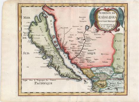
Lot 310
Audience de Guadalajara, Nouveau Mexique, Californie, &c. This map was first published in 1656 and introduced the so-called second Sanson model of California as an island. This depiction shows a small peninsula (Agubela de Cato) above the island, two bays along the island`s northern coast and two new place names, Tolaago and R. de Estiete. Sanson actually based this on information from the less well known map by Luke Foxe, but it was this map that influenced many other cartographers throughout the rest of the century. On the mainland there are new Indian tribes identified in the region of the R. del Norte, which flows southwest from a large inland lake. This example was published in Joannes Ribbius` very rare Dutch translation of Sanson`s L`Amerique en Plusieurs Cartes. The map was re-engraved for this edition, with only very minor differences from Sanson`s map of 1657. This is the first state of the Ribbius edition, prior to the addition of a grid of longitude and latitude. A nice impression on watermarked paper with attractive color. 7.9 W x 9.3 H Sanson, Nicolas 1683

Lot 328
Carta Esferica de las Costas y Golfo de Californias Llamado Mar de Cortes que Comprende Desde el Cabo Corrientes Hasta el Puerto de S. Diego... This rare sea chart was created for Guadalupe Victoria, the first president of Mexico shortly after Mexico gained independence from Spain. The map is a copy or a derivative of a map created in Spain by the Direccion de Hidrografia (Spanish Hydrographic Service). This map is one of a number of Spanish charts that were reissued in 1825 by the new Mexican government. The chart depicts Baja California (beginning at San Diego) and the eastern coastline of the Gulf of California south to C. Corrientes, which is just south of Puerto Vallarta. Soundings, rocks, shoals, and anchorages are noted along the coasts. Although the interior is left blank, the topography of the coastlines is illustrated by hachures. At top are three large insets depicting plans of the Port of Guaymas along the eastern coast of the Gulf of California, and the Bay of La Paz and Port of Pichilingue near the southern tip of Baja California. A bright, clean example that has been backed with Japanese tissue to help reinforce an archivally repaired tear that enters about 10"" into map at top. The bluish shadow that appears along the centerfold is caused by our scanner, and does not appear on the map. 34.2 W x 22 H Direccion de Hidrografia, 1825
![Plan of the Road and Town of La Guayra on the Coast of Caraccas... [on sheet with] Plan of Puerto Cavello on the Coast of th](http://lot-images.atgmedia.com/SR/36385/2906594/373-20145813523_468x382.jpg)
Lot 373
Plan of the Road and Town of La Guayra on the Coast of Caraccas... [on sheet with] Plan of Puerto Cavello on the Coast of the Caracas This rare sheet includes plans of two of the most important port cities in Venezuela. At top is a plan of La Guaira, which was originally founded in 1589 as the gateway to Caracas, and is now the capital of the modern state of Vargas. The plan depicts fortified walls and numerous buildings, including a church, prison, warehouse, watch house, and Fort Colorado. Rocks, shoals, soundings, and safe anchorages are depicted in the surrounding waters. The plan was made by an officer under Sir Charles Knowles, who attacked the port in 1743 during the War of Jenkins` Ear in an attempt to weaken the Spanish stronghold. The British were defeated due to their underestimation of the port`s defenses.After the failed attack of La Guaira, Knowles refitted his ships and attempted an assault on Puerto Cabello, shown in the plan at bottom. Knowles was again beaten by the defenders and forced to withdraw his force. This plan of Puerto Cabello identifies a stony beach, mangroves, salt pans, and an area of swampy ground. The plan is based on the work of Lieutenant Jones in 1741. Heavy, watermarked paper with a few spots of foxing and marginal soiling. 17.4 W x 10.5 H Laurie & Whittle, 1794

Lot 392
Le Chili. Tire de Celuy que Alf. de Oualle P. de la C.d.I. a Fait Imprimer a Rome en 1646. Et Distingue en ses Treize Iurisdictions This important map of Chile, showing the Cuyo provinces (Chucuito), is based on the descriptions of Alfonso de Ovalle, a Chilean-born Jesuit. Ovalle created the first comprehensive history and description of Chile, which was published in 1646 and is extremely rare. This map is the first widely available edition of Ovalle`s map. Detail is primarily confined to the region west of the Andes, with numerous rivers and towns noted, including Santiago, Concepcion, and Valdivia. The map extends south to the Magellan Strait, and is graced with a lovely title cartouche that complements the scientific style of the cartography. Watermarked paper with original outline color in the map and later coloring in the cartouche. There is some scattered foxing in the image. 21.1 W x 15.2 H Sanson/Mariette, 1656

Lot 421
Pascaart Vant Canaal Tusschen Engelant en Vrancryck Tabula Hydographica Freti seu Canalis Rare and elegantly engraved chart of the British Isles and English Channel, based on a chart by Anthony Jacobsz from 1644. Place names are confined to the coastlines, and soundings, rocks, shoals, and other navigational information are included. Two decorative compass roses orient north to the right. The title cartouche is flanked by two ancient Britons, who stand upon sea monsters and hold the royal coat of arms. This is the first state, prior to the names of the seas being added. French text on verso. A good impression with minor show-through of text on verso, a couple of tiny spots, and a small hole off the southwestern coast of Wales that has been professionally infilled. 17.25 W x 22 H Jansson, Jan 1650

Lot 483
Flandria This is the rare, first of three plates of Flanders that Ortelius published in his monumental Theatrum Orbis Terrarum. The map extends from Zeeland and Antwerp in the north to Calais in the south, and as far east as Douai and Brussels. Rivers, forests, political boundaries, and hundreds of towns are shown, with the largest cities marked with miniature bird`s eye views. The map is embellished with galleons engaged in battle, a sea monster, and an allegorical female figure holding a bundle of grains and the coat of arms of Flanders. The map is enclosed in an elegantly engraved egg-shaped border. Latin text on verso. Van den Broecke estimates that fewer than 75 copies of this map were printed for the 1573 edition. Nice impression and color on watermarked paper with one tiny hole in image, a few small abrasions, and a professionally repaired centerfold separation. Expertly remargined all around with repairs to a few tears and chips entering border of map with excellent facsimile work of neatline in a few spots and decorative border at top and bottom left. 15.2 W x 19.6 H Ortelius, Abraham 1573

Lot 497
Hispaniae Nova et Exacta Descriptio This very rare map of Spain and Portugal was published only in the first edition of Paulus Merula`s Cosmographiae Generalis, which included 5 larger maps engraved by Johannes and Baptista van Doetecum and 38 maps from Petrus Bertius` Tabularum Geographicarum. The map extends to the Balearic Islands and the northern tip of Africa, and is filled with details of towns, rivers, mountains, and political boundaries. Elegantly engraved by Baptista van Doetecum, the map is embellished with a compass rose, sailing ship, and delicately patterned sea. The strapwork title cartouche encompasses the distance scale and is topped with the Royal coat of arms of Spain, ruled by the House of Habsburg.Merula, a Dutch jurist, was appointed to the chair of history at the University of Leyden in 1592. In addition to this geography he also published folio editions, wrote many treatises on laws and history, and is also known for his geological studies. A fine impression with attractive color on watermarked paper. Issued folding, now pressed, with minor offsetting and a binding trim at left that has been professionally repaired. 9.2 W x 12.8 H Merula, Paulus G. 1605

Lot 534
Tabula Russiae ... Alias Dicta Moscovia Attractive and unusual map including all of Scandinavia through to the Black and Caspian Seas. The map is based on Hessel Gerritsz` rare and significant map of Russia, compiled from manuscripts brought back by Isaac Massa. The arc north of Crimea marks the defense line from the upper reaches of the tributaries of the Dnipro down to the Volga. Richly decorated with a large title cartouche, three Russian gentlemen, and a view of Archangel Sckagoroda., the port of Arkhangelsk. A clean, bright example with archival repairs to a centerfold separation and a edge tear confined to bottom blank margin. 11 W x 13.7 H Merian, Matthaus 1660

Lot 536
Grade Russie ou Blanche avec Ses Confins This small map of western Russia shows the area between the Baltic, Black, Caspian, and Barents Seas. Hundreds of towns, political boundaries, and rivers are well delineated. This map appeared in Picart`s very rare Tresor des Cartes Geographiques, which was first published in 1651. Picart based the maps off of Jean Boisseau`s Tresor des Cartes from 1643. Picart`s plates were apparently passed down to Antoine de Fer, who, together with Pierre Duval, republished them with some changes for Cartes de Geographie in 1657. A nice impression with light soiling. 5.5 W x 7.3 H Picart, Nicolas 1651

Lot 543
Graetia Nova Tabula Rare little Ptolemaic map covering Greece, extending to include a bit of Italy and Turkey. The topographical features such as mountain ranges and river systems are boldly drawn and major cities are located. Italian text on verso. There are two small worm tracks along centerfold at top that have been professionally repaired with a tiny amount of image replaced in facsimile. 5.2 W x 6.9 H Gastaldi, Giacomo 1548

Lot 570
A New Sea & Land Chart of the Sovereign Principality of Malta; Laid Down from the Best Authorities and the Different Manuscript Maps Communicated to the Chevr. Louis de Boisgelin... This rare, desirable and very detailed engraving depicts the islands of what is now called ""The Republic of Malta"", the southern-most of European countries. The map was published in Boisgelin`s definitive history ""Ancient and Modern Malta: Containing a Full and Accurate Account...."" published in 1805. The map displays the larger islands of Malta, Gozo and lesser isles with a large pictorial title cartouche depicting a Knight of Malta reaching for a sinking ship flying a flag with a Maltese Cross. The detail is fine enough to include roads as well as structures in the rural areas. Topography is shown through dense hachuring, and the coastline is marked with soundings and anchorages. The Malta Historical Society has stated that ""of all the printed maps of Malta, Boisgelins map is the second largest, coming only after the Carte Generale de la Principaute Souveraine des Isles de Malte et du Goze (53.1x 22.8""), made by Gervais de Palmeus and published in Paris in 1752."" First edition, published by G. & J. Robinson, Pater-noster Row. Printed on two sheets, joined as issued. Issued folding with moderate offsetting and a few extraneous creases. There are several short splits at fold intersections and some small tears along the sheet edges confined to the blank margins, all of which have been closed on verso with archival tape. 21.6 W x 50.8 H Neele, Samuel John 1804

Lot 695
Nouvelle Carte des Decouvertes Faites par des Vaisseaux Russiens aux Cotes Inconnues de l`Amerique Septentrionale avec les Pais Adiacents... This is an uncommon Dutch edition of Gerhard Muller`s landmark map of 1754 showing the discoveries of Captains Bering and Tschirikow. Muller was a German scholar who worked for the Russian Imperial Academy of Sciences. He originally published his map in response to Joseph Delisle and Philippe Buache`s map that showed previously unknown Russian discoveries and an elaborate (and entirely speculative) depiction of the imaginary voyage of Admiral De Fonte through a Northwest Passage. Muller`s map shows an elongated landmass roughly in the shape of the Alaskan Peninsula and the Aleutian Islands. The speculative Northwest Passage is shown nearly connecting to Hudson Bay via a mythical River of the West. Muller`s map was copied numerous times by different publishers due to increased interest in the region and the De Fonte controversy. This edition was published in 1766 by Marc Michel Rey in Amsterdam with minor changes to the title cartouche and publishing information has been added in the bottom margin. A rare and fascinating addition to any collection of the Pacific Northwest. Printed on two joined sheets, as issued. Issued folding on watermarked paper with light toning and a few spots of foxing, mostly along the left edge of the sheet. 17.6 W x 24.8 H Muller, Gerard Friedrich 1758

Lot 707
Pavillons d`Espagne &c. / Spaanse Vlaggen &c. In the 1680`s, Jean-Baptiste Colbert, Minister of Finance of France under the rule of King Louis XIV, commissioned a group of astronomers, mathematicians, and hydrographers to map the coast of the Europe from Norway to Gibraltar. The result of their efforts was Le Neptune Francois, first published in 1693 by Alexis-Hubert Jaillot. Pierre Mortier, having been granted in 1690 the privilege of distributing in Holland the maps and atlases of French publishers, republished Le Neptune Francois the same year with re-engraved plates. Le Neptune Francois was the most expensive sea atlas published in Amsterdam during the latter part of 17th century. Mortier published further additions in English, Dutch, and again in French circa 1700-03. In a few of these later French and Dutch editions, Mortier included 12 engravings of sea flags. Because Mortier`s sea flags were only published in a few editions, they are extremely rare. This engraving depicts the flags of the Kingdom of Spain, the Kingdom of Portugal, Castille, several variations for Portugal, and Burgundy. A fine impression with minor soiling and light toning along the bottom edge of the sheet. Top and bottom margins are narrow, as issued. There is slight tackiness on verso, as the engraving was professionally removed from an archival board. 19.5 W x 20.8 H Mortier, Pierre 1700

Lot 708
Pavillon d`Italie &c. / Italiaanse Vlaggen &c. In the 1680`s, Jean-Baptiste Colbert, Minister of Finance of France under the rule of King Louis XIV, commissioned a group of astronomers, mathematicians, and hydrographers to map the coast of the Europe from Norway to Gibraltar. The result of their efforts was Le Neptune Francois, first published in 1693 by Alexis-Hubert Jaillot. Pierre Mortier, having been granted in 1690 the privilege of distributing in Holland the maps and atlases of French publishers, republished Le Neptune Francois the same year with re-engraved plates. Le Neptune Francois was the most expensive sea atlas published in Amsterdam during the latter part of 17th century. Mortier published further additions in English, Dutch, and again in French circa 1700-03. In a few of these later French and Dutch editions, Mortier included 12 engravings of sea flags. Because Mortier`s sea flags were only published in a few editions, they are extremely rare. This engraving depicts the flags of the Pope of Rome, Monaco, Ragusa, Tuscany, Savoy, Livorno, Genoa, Modena, and Jerusalem. A fine impression with a short printer`s crease at bottom center, a 1/2"" tear at bottom that has been closed on verso with archival tape, and a narrow bottom margin, as issued. There is slight tackiness on verso, as the engraving was professionally removed from an archival board. 19.4 W x 20.7 H Mortier, Pierre 1700
![[Illuminated Leaf] A very rare and unusual vellum leaf from a Dutch Book of Hours. The border on the recto is illuminated i](http://lot-images.atgmedia.com/SR/36385/2906594/718-201458131631_468x382.jpg)
Lot 718
[Illuminated Leaf] A very rare and unusual vellum leaf from a Dutch Book of Hours. The border on the recto is illuminated in a sophisticated fountain-style array of acanthus leaves in red, green and dark blue. There is one large initial illuminated in gold. This decoration is often found in books illuminated by the Masters of the Haarlem Bible; these masters took their name from a three-volume bible made for the Knights of St. John in Haarlem, Holland. The text is from the Book of Hours translated into Dutch, probably by Geert Groote. Most medieval books were written in Latin, the language of the church. Geert Groote, the father of the Devotio Moderna, or Broederschap des Gemenen Levens as his movement was called in Dutch, was a great advocate of the vernacular in religious books.Beginning with the large initial at the bottom of the recto is Job 10:I loathe my very life;therefore I will give free rein to my complaintand speak out in the bitterness of my soul. Clean and bright with some fading of a few words and minute worm holes that are only visible when held to light. 5.1 W x 3.7 H Anon., 1470

Lot 751
The American Geography; or, a View of the Present Situation of the United States of America... With the folding maps: ""A Map of the Northern and Middle States; Comprehending the Western Territory and the British Dominions in North America from the Best Authorities;"" ""A Map of the States of Virginia, North Carolina, South Carolina and Georgia; Comprehending the Spanish Provinces of East and West Florida;"" and ""A Map of Kentucky Drawn from Actual Observations."" Rebound in quarter faux leather over red marbled boards. Quarto, 642 pp. (deckled edges) with three folding maps. This is the John Stockdale edition published from London. Of particular interest is the rare Kentucky map which was first produced by Filson in 1784 and here republished in 1793. The map extends from the Ohio River in the north to the Cumberland River in the south and shows three counties: Fayette, Jefferson and Lincoln. It is filled with notations including ""a bloody battle fought here"" and ""the large Bones are found here"", settlements, the river system and topography. Includes an inset at top ""A Plan of the Rapids, in the River Ohio"" which was not on the 1784 edition. John Filson (1753 - 1788) was the first Historian of Kentucky. Moving from Pennsylvania about 1782, he settled in Lexington where he divided his time between teaching and surveying land claims. He wrote The Discovery, Settlement and Present State of Kentucke in 1784. In 1788, while on a surveying expedition near the Great Miami River, he disappeared when the party was attacked by Shawnee Indians. The second map, by Joseph Purcell, is an uncommon, early depiction of the Southeast and shows a well defined New State of Franklin, within the borders of North Carolina. In 1785, settlers in present-day western North Carolina and eastern Tennessee organized a state government to be named in honor of Benjamin Franklin. Congress turned down their appeal but the state maintained a legislature and governor until 1788. This ephemeral state appeared on a small number of maps into the early part of the 19th century. The map shows early settlements, including a Moravian Settlement in North Carolina, and the Cumberland Settlements in present-day Tennessee. The map also notes native tribes and various Bounty Land Grants lands along the upper Mississippi River. The third map of the Northern and Middle States describes the area from Maine (Province of Main), south to Virginia. Lesser detail extends west to the Great Lakes and the confluence of the Ohio and Mississippi Rivers, and north to eastern Canada up to James Bay. There are several Bounty Land Grants including Genl. Clarks, Donation Lands from the Commonwealth of Virginia, and Ohio Company in Ohio, and Wabash Company, New Jersey Company, and Illinois Company in Illinois. This is the first edition, with information taken from Amos Doolittle`s map of the same title. Condition code is for the maps which have moderate to heavy offsetting with numerous fold separations closed on verso with old paper and archival tape. Text is good with some light scattered foxing, and the top blank margin of the title page has been replaced with old paper. New binding is excellent. 11.5 W x 9.2 H Morse, Jedidiah (Rev.) 1794
![[Three Facsimile Volumes] A Journey in North America, Containing a Survey of the Countries Watered by the Mississipi, Ohio,](http://lot-images.atgmedia.com/SR/36385/2906594/754-201458131739_468x382.jpg)
Lot 754
[Three Facsimile Volumes] A Journey in North America, Containing a Survey of the Countries Watered by the Mississipi, Ohio, Missouri, and Other Affluing Rivers This example is a 1924 reprint of Collot`s famous journey to the interior of the United States. In 1796, Collot was appointed by Pierre Adet to reconnoiter the interior parts of the country. Adet was concerned that the United States would join British forces in the Anglo-Spanish War and needed better intelligence on the area if they did. Collot`s journey took him from Pittsburgh down the Ohio River, and then up to St. Louis on the Mississippi before finally heading downstream to New Orleans where he was promptly arrested by the Spanish. He was released shortly thereafter and returned to France in 1800 with the intention of publishing his maps and notes. Collot died in 1805 prior to printing, but his accounts were eventually published by the firm of Arthur Bertrand in 1826. A mere 300 French copies and 100 English copies were produced. This reprint includes two separate volumes of text (310 pp. and 290 pp. respectively) and an atlas volume with 36 folding maps, several of which are large. Published for Reprints of Rare Americana No. 4. Hardbound in quarter calf and tips over marbled boards. Overall the maps and text are clean and bright but are stiff and rippled throughout. A few of the maps have small edge and binding tears with the most notable being a 5"" binding tear in plate 29 (Map of the Missouri). Covers and spine show typical wear with bumped corners and the front hinge of volume 1 has separated. 13.5 W x 10.2 H Collot, George Henry Victor 1924

Lot 128
IVAN D. TSHITSHELEV.Rare parure en vermeil ornée démaux cloisonnés polychromes comprenant : un bracelet ouvrant en forme darceau ou « douga » de cheval de traineau stylisé, une broche assortie ainsi quune paire de boucles doreilles. Des chaînettes en or jaune (rapportées ultérieurement) viennent agrémenter ces bijoux, retenant des petits grelots ou des clochettes émaillés. Dans son écrin à la forme. Poids brut total : 84,2 g (transformations)Provenance : ancienne collection Jean Bardou, fondateur des papiers à cigarettes JOB, qui laurait acquise à lExposition Universelle de 1889, et conservée dans cette famille depuis lors.Ivan Dmitrievitsh TSHITSHELEV (1829-1893) un des plus importants joailliers de Moscou sous le règne dAlexandre II. Originaire de Pereslavl-Zalesski, fils de marchand, il ouvre son atelier en 1850. Il est inscrit en 1866 à la deuxième guilde des marchands de Moscou. Il a été choisi en 1868 comme expert de linventaire estimatif des joyaux de la succession du saint métropolite Philarète de Moscou (décédé en 1867). Il sest vu confié la restauration de montures en or de coupes antiques des collections du Musée Historique dans les années 1870. Il a été également un des trois fournisseurs en objets de culte de la cathédrale du Saint-Sauveur (consacrée en 1883). Fournisseur à la cour de Russie (12.09.1870), du roi Victor-Emmanuel et de lEmpereur François-Joseph, il est décoré de lordre de Sainte Anne de 3 classe et de Saint Stanislas de 2 classe en 1878. Il devient vers 1880 « citoyen dhonneur héréditaire ». En 1908, son frère Vassili qui avait été le directeur de la maison, solde le stock pour cause de fermeture. Son activité portait aussi bien sur des parures et bijoux en or ornés de diamants, des bijoux émaillés, des objets religieux et des décorations. Il se distingue ainsi à lExposition Universelle de Vienne en 1873 où son diadème orné de perles et de diamants subjugue les visiteurs par son exubérance et la qualité du travail effectué. Le roi Victor-Emmanuel a acheté ce diadème et un collier lors de cette exposition. Le style antique russo-byzantin a participé à la gloire de la maison, au même titre que les montures de diamants. Il faut préciser ici quà cette époque, deux grands courants créatifs principaux guident les artisans : un courant très « classique », résolument tourné vers lEurope occidentale à Saint-Petersbourg, et un courant « pan-russe » à Moscou où la tradition populaire est remise au goût du jour et en quelque sorte renouvelée, réinterprétée. Cest dans cette voie là que sinscrit notre parure.Les pièces de Tshitshelev sont particulièrement rares : un bracelet-manchette se trouve au Musée Historique de Moscou ; le Palais des Armures du Kremlin a récemment reçu en donation une broche transformable en pendentif. Elles apparaissent rarement dans le marché de lart, et la plupart dentre elles sont à caractère religieux. La parure que nous présentons aujourdhui en est donc un exemple dautant plus unique.Voir notamment : C. Gere & J.Rudoe, « Jewellery in the Age of Queen Victoria », 2010, p.281.


Lot 305
Tremont Watch Co. silver lever pocket watch, the movement signed Tremont Watch Co, London, no. 9815, signed dial within an engine turned case, 51.5mm *This watch is a rare survivor. The Tremont Watch Co of Boston was very short-lived (1864-1866). Sold to the Melrose Watch Co which also became bankrupt and the assets were sold to Dennison and shipped to England for sale

Lot 827
Great Northern Railway/L.& N.E.R. (possibly Stafford and Uttoxeter Railway) mahogany single fusee wall dial clock, the 8" dial inscribed `G.N.R 450` (ex-Salt & Sandon Booking Office), with ghost inscription `J.J Stockall & Sons Limited, London; pendulum *The GNR dial on this clock is a rare survivor, especially as the Salt & Sandon station closed on the 4th December 1939

Lot 853
South Eastern & Chatham Railway oak single fusee drop dial wall clock, the 12" dial inscribed `S.R 144SE` (ex-Ashford - Chief Mechanical Engineers Department Fire Brigade Office), signed John Walker 1 South Molton St, London, SE & CR number plate to the side door, the movement back plate stamped `G&B` and `SE&CRy` within oval cartouches, the case back branded `1443S.E`, circa 1910, 20" high; pendulum bob stamped `1443` (glass loose) *Clocks retaining Southern Railway dials are considerably rare as BR instructions to Walkers were to have the dials rewritten BR (S) specification on the first opportunity when passing through the repair shops after nationalisation

Lot 874
Rare Great Eastern Railway (L&NER) mahogany single fusee wall dial clock, the 14" convex dial inscribed `G.E.R` with applied ivory number plate `4003`, the movement back plate stamped `GER`; pendulum *it is rare to find a convex dial railway wall clock, this clock is in good restored condition

Lot 1328
Good and rare Black Forest musical flute two train automata clock by Emillian Wehrle in Furtwangen, the 7.25" silvered chapter ring signed Camerer Kuss, New Oxford St, over two doors revealing the standing figure of a flautist in traditional costume, the movement with interchangeable cylinder, within a panelled stepped case applied with foliate strapwork and surmounted by an ornate cornice, 31" high; also with matching bracket *This is a very rare clock produced by a maker who developed a niche for selling expensive musical clocks to people who could afford them. We have only managed to trace one clock similar to this which sold in America for $10,000

Lot 1358
Rare early French Atmos clock, the 3.5" white dial inscribed Atmos, Pendule Perpetuelle, no. 1349, with original Atmos clockwork, within a polished nickel glazed case, 9.5" high *The concept of this clock with mercury and gas fluctuations changing under variable weather conditions was invented by the French engineer Jean Reutter


-
209236 item(s)/page