We found 216134 price guide item(s) matching your search
There are 216134 lots that match your search criteria. Subscribe now to get instant access to the full price guide service.
Click here to subscribe- List
- Grid
-
216134 item(s)/page


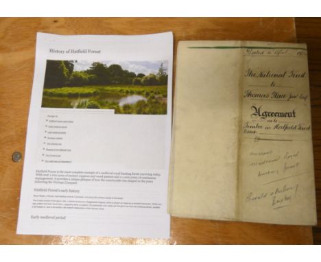
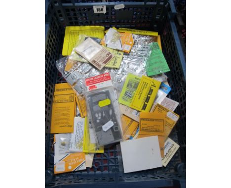
Lot 115
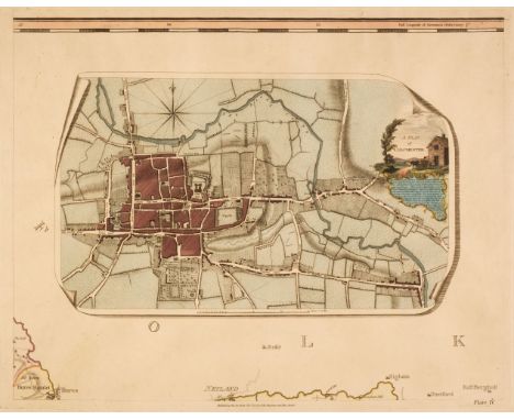
Documents - Essex - Hatfield Forest - The National Trust. 1924 Agreement, The National Trust to Thomas Place Junior, as to timber in Hatfield Forest, reciting six parts to the agreement Edward Buxton & Anthony Buxton; also Clayton's Agreement. With fine large scale plan of the Forest. Signed & sealed by Nigel Bond, Secretary of The National Trust. "Hatfield Forest is a (996 acre) biological Site of Special Scientific Interest in Essex, near Bishop's Stortford. It is also a National Nature Reserve & a Nature Conservation Review site. It is owned & managed by The National Trust. Hatfield is the only remaining intact Royal Hunting Forest & dates from the time of the Norman kings. Given to the Trust in 1924 by the Buxton family".
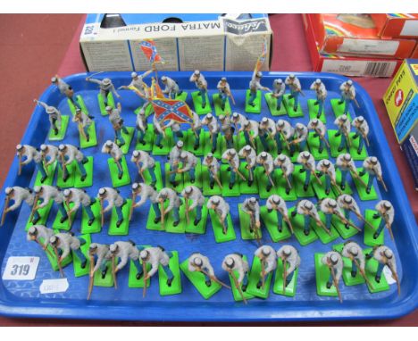
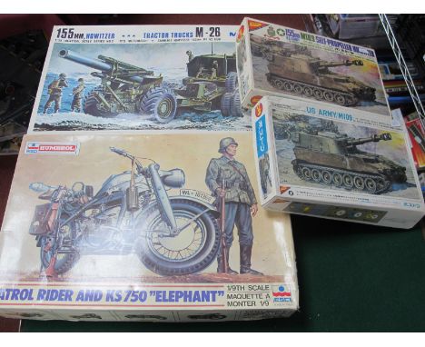
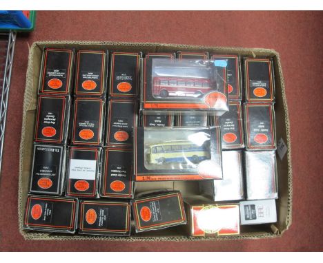
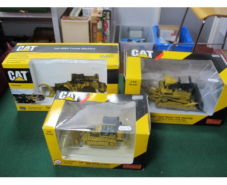
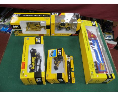
Lot 8028
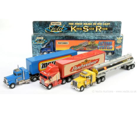
Matchbox Collectables group of unboxed Big Rig Trucks (1) Peterbilt Truck "Matchbox" 1 of 3500; (2) Matchbox Ultra Freightliner C.O.E. - Budweiser; (3) Peterbilt Fuel Tanker - Formula Shell; (4) Matchbox Gold Collection King Size Rigs - 42731 Matchbox Action System 1/64th scale Truck in original packaging - Excellent to Near Mint mostly unboxed. (4)
Lot 8175
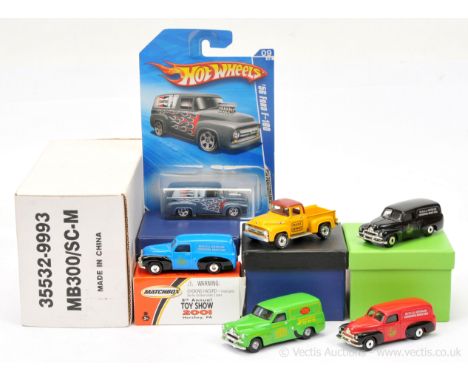
Matchbox including Code 2 issues to include Matchbox Superfast FJ Holden Panel Van - 6th MICA Australian Convention March 2003 - red in custom box, another similar but blue/black and another all in black, other items includes Trax Hot Wheels Matchbox Toy Show 2001 and MB300/SC Ford F100 Pick-up Truck in a similar scale - Excellent to Mint. (7)
Lot 8562
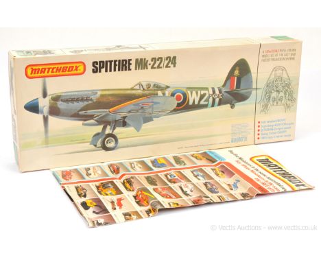
Matchbox 1/32nd scale RAF Supermarine Spitfire Mk.22/24 plastic kit - although unchecked for completeness this does appear complete with just the lower fuselage detached from sprues - Mint complete with unused decal sheet, instructions & inner card packing piece in Good Plus box with some staining to base. Nice example of a hard to find kit consigned by ex Lesney employee. Along with 1983 wall chart which is heavily folded and only Poor to Fair. (2)
Lot 188
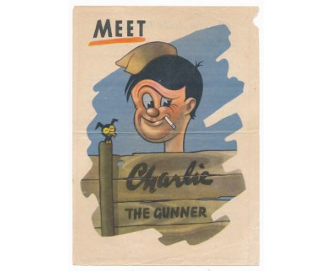
'Meet Charlie The Gunner' Second World War German airborne Propaganda leaflet. Double sided leaflet front reads 'Meet Charlie the Gunner', reverse states 'Charlie tells the truth!' Just now I want you to keep your brains clear, for in the coming weeks the big show is timed to start on the Italian Front. What do I mean? Well our officers are talking about large scale attacks against Jerry. We could of course wait until the bloody thing was over , but no, we must get ready for new attacks'. Folded. 14.5cm x 20.5cm.
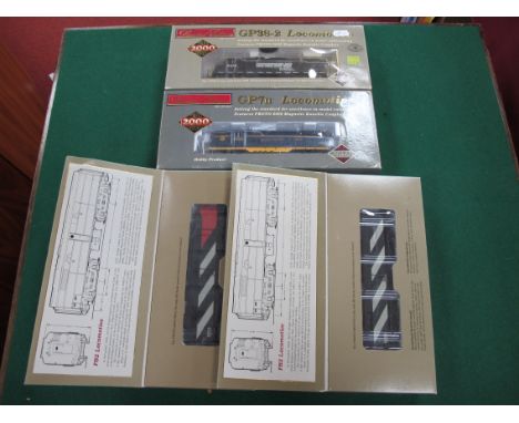
Lot 143
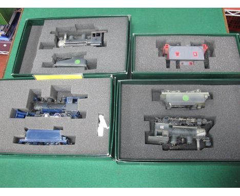
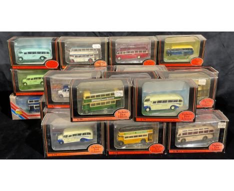
Three Spectrum 'HO' Gauge U.S.A Outline Steam Locomotives with Eight Wheel Bogie Tenders, On 30 scale, Ref No 25212 2-6-0, Ref No 25299 2-6-0 and Ref No 257602-6-0 (missing front bogie), all three in fair u/t boxed condition small parts detached, plus a spectrum boxed Ref No 127799 caboose with poor paint (4).
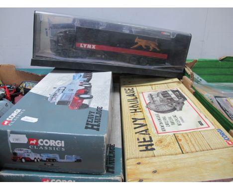
Lot 64
Four Boxed 1:50th Scale Corgi Diecast Model Commercial Vehicles, comprising of #17601 Hills of Botley Scammell Constructor and Twenty Four Wheel Low Loader, #31007 Heavy Haulage Annis and Co. Ltd Diamond T Ballast with girder trailer and locomotive load (box poor), #CC12507 Atkinson Venturer 'Pickfords' (box poor), #75001 ERF EC Box Trailer 'Lynx Express' (wear/dust to perspex box).
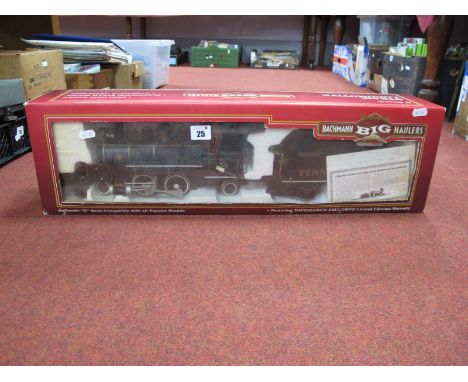


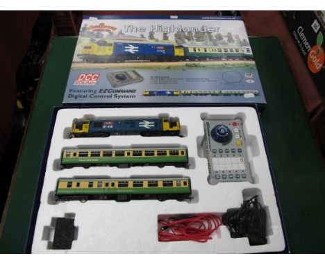
Lot 246
A Bachmann Branch Line #30-048 The Highlander 'OO' Scale Digital Sound Train Set. including Class 37/4 diesel locomotive, R/No 37418, 'AN Comunn Galdhealach' BR large logo, (missing buffer), two MK2 green and cream coaches (T50 and B50), E-Z command digital controller, track (incomplete), boxed.


Lot 40
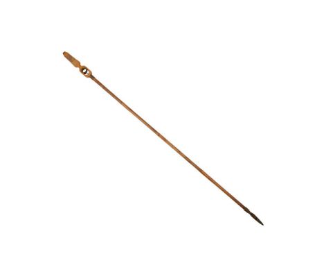
FRENCH ADRIEN DUBOIS COMBINATION BOTANY GADGET CANE CIRCA 1880 - 1920 bamboo cane with finger pull in the ash handle that allows the shears to the end to snip, the handle also with a small concealed pollination brush and gilt-stamped 'Fleur' and 'Fruit' verso with a brass cap to the end, the cane and handle with ink inscription 'T. Methven, 15 Princes St, Edinburgh'Dimensions:119cm longProvenance:Provenance: Thomas Methven was a noted Scottish botanist and businessman that set up the firm of Thomas Methven & Sons based at 15 Princes Street, Edinburgh. They were large-scale purveyors of seeds, nursery plants and also a florist. The firm once had premises on Macdonald Road and several nurseries based around the city including at 9 Croall Place, Leith Walk and Warriston, Inverleith and Bangholm. Following the death of their father, the business was run by his sons Henry & John Methven. John was closely connected with the two important Scottish horticultural societies, the Royal Caledonian and the Scottish Association. He also had links with the Royal Scottish Arboricultural Society.Note: Note: For an identical example see the collection of the Isabella Stewart Gardner Museum
Lot 27
Large Scale County Maps. A collection of 38 sheets from various maps, 18th & 19th century, large-scale engraved map sheets, many with contemporary hand-colouring, including examples from Benjamin Donne's map of Devon, Chapman & André's map of Essex, Andrews and Dury's Sixty-five miles round London, John Rocque's map of Berkshire, Hodskinson's map of Suffolk, Taylor's map of Gloucestershire and Armstrong's map of Lincolnshire, occasional duplicates, some sheets torn and frayed with occasional loss, a few sheets town along the central fold, various sizes and conditionQTY: (38)
Lot 32
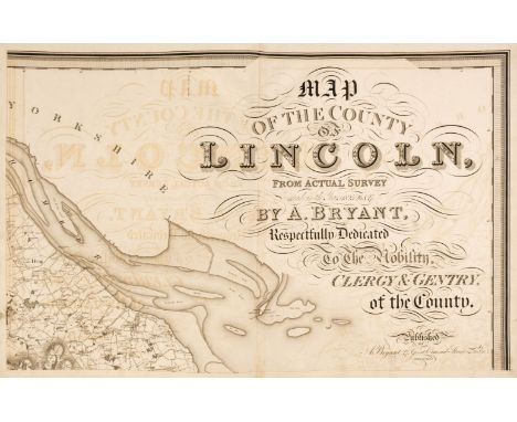
Lincolnshire. Bryant (Andrew), Map of the County of Lincoln from Actual Survey within the years 1825, 26 & 27..., Respectfully Dedicated to the Nobility, Clergy & Gentry of the County, April 19th 1828, large scale engraved map on eight double-page sheets, calligraphic title, compass rose, tables of explanation and divisions, engraved vignette of Lincoln Cathedral, some offsetting throughout, occasional small repaired marginal tears, each sheet approximately 530 x 815 mm, contemporary half sheep, lacking spine, boards detached, heavily worn and frayed, slim folio, binding size 585 x 465 mmQTY: (1)NOTE:The first and only edition of this large-scale map. Bryant produced 13 county maps very much in the style of the Greenwood brothers.
Lot 45
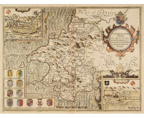
* Pembrokeshire. Speed (John), Penbrokshyre described and the Sittuations both of Penbroke and St. Davids shewed in due form as they were taken..., Thomas Bassett & Richard Chiswell [1676], hand-coloured engraved map, inset town plans of Pembroke and Saint Davids, large strapwork cartouche, 385 x 510 mm, mounted, framed and double-glazed, English text on verso, together with Blome (Richard). A Generall Mapp of South Wales..., circa 1673, hand-coloured engraved map, old folds, some spotting, 350 x 460 mm, mounted, framed and glazed, with Saxton (Christopher & Hole G.). Caernarvo. Comitatus pars olim Orovicum [1627], hand-coloured engraved map, large strapwork cartouche, compass rose and mileage scale, 255 x 310 mm, mounted, framed and glazedQTY: (3)
Lot 50
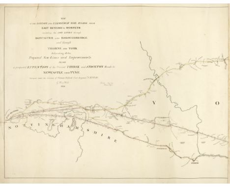
Road Maps. Telford (Thomas). Three Monumental road maps: Map of the London and Edinburgh Mail Roads from London to East Retford, including the two Lines to Alconbury Hill through Hatfield and Ware..., 1827, Map of the London and Edinburgh Mail Raods from East Retford to Morpeth including the two Lines through Doncaster and Boroughbridge and through Thorne and York..., 1826 [and] London and Morpeth Mail Road Index Map, Surveyed by Thos. Telford, printed at the Lithographic Establishment Quarter Master Gen.ls Office, Horse Guards, 1827, lithographic maps with contemporary outline colouring, the first described item on five sheets, torn with slight loss to the lower left corner of the first sheet, old glue marks to the margins where previously conjoined, each sheet approximately 475 x 670 mm, the second item on six sheets, old glue marks where previously conjoined, closed marginal tear on the left-hand vertical margin, each sheet approximately 470 x 605 mm, the third item on seven sheets, some dust soiling, occasional marginal closed tear with slight loss, each sheet approximately 660 x 500 mmQTY: (18)NOTE:Scarce monumental road maps on a scale of 2 miles to the inch.
Lot 33
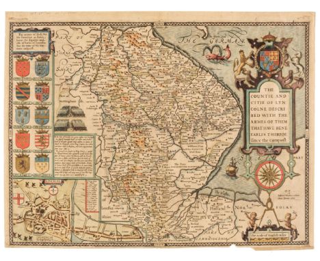
Lincolnshire. Speed (John), The Countie and Citie of Lyncolne Described with the Armes of them that have bene Earles thereof since the Conquest, 1st edition [1611], hand-coloured engraved map, inset city plan of Lincoln, large strapwork cartouche and compass rose, small chip in the lower border with slight loss to the strapwork margin, 385 x 515 mm, English text on verso, together with Blaeu (Johannes). Comitatus Brechiniae Breknoke, Amsterdam, circa 1648, engraved map with contemporary hand-colouring, decorative cartouche and mileage scale, mount stained and a little toned, 380 x 505 mm, German text on versoQTY: (2)
Lot 1
Bartholomew (John). The Imperial Map of England & Wales According to the Ordnance Survey..., A. Fullarton & Co. London & Edinburgh, circa 1870, index toned, 18 colour lithographic double-page map sheets, slight spotting throughout, lacking front endpaper, rear endpaper torn with some loss, contemporary cloth gilt, upper board detached, heavily worn and frayed, folio, together with Ordnance Survey (publishers). Ordnance Survey Atlas of England & Wales, and Ordnance Survey Atlas of Scotland, 2 volumes, 1922 - 24, double-page colour lithographic maps, on a scale of a Quarter Inch to the Mile, each map backed with linen, slight spotting throughout, publisher's cloth gilt, The Atlas of England & Wales, toned, frayed and with spine partially detached, oblong folio, with another copy of the Atlas of England and Wales, with Bowen (Emanuel). An Accurate Map of the Counties of Leicester and Rutland Divided into their Respective Hundreds..., circa 1765, engraved map with contemporary outline colouring, sectionalised and laid on linen, thread margins, contained in a contemporary marbled card slipcase with printed label to the upper cover, worn and frayed, plus another nine late 19th & early 20th-century folding county maps, touring maps and town plans, including examples by or after Stanford, Bartholomew, Bacon and Ordnance Survey, various sizes and conditionQTY: (14)NOTE:Sold as a collection of maps, not subject to return.
Lot 30
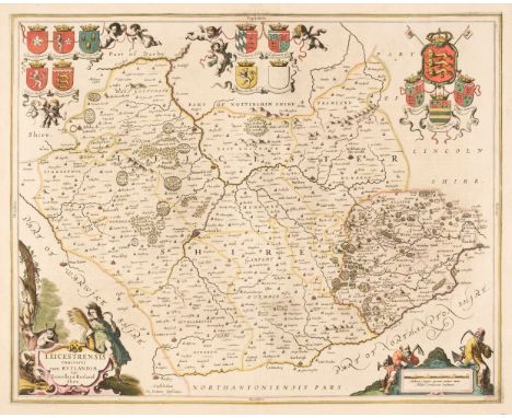
Leicestershire & Rutland. Jansson (Jan), Leicestrensis Comitatus cum Rutlandiae vulgo Leicester & Rutlandshire, Amsterdam, circa 1650, engraved map with contemporary outline colouring, decorative cartouche and mileage scale, slight staining, 440 x 550 mm, French text on verso, together with Blaeu (Johannes). Leicestrensis Comitatus Leicester Shire, Amsterdam, circa 1648, engraved map with contemporary outline colouring, decorative mileage scale, 385 x 500 mm, French text on versoQTY: (2)
Lot 40
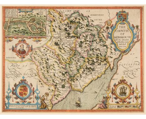
* Monmouth. Speed (John), The Countye of Monmouth with the situation of the Shire-towne Described, John Sudbury & George Humble, circa 1627, engraved map with early hand-colouring, inset town plan of Monmouth, large strapwork cartouche and mileage scale, additional faint vertical fold, 385 x 510 mm, mounted, framed and double-glazed, English text on versoQTY: (1)
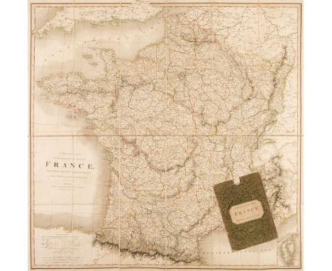
Lot 19
Folding Maps. A Collection of Seven Maps, mostly 19th century, including Smith (C.). A Physical and Topographical map of France, Describing the Post Roads & Relays with the Inland Navigation &c. 1st March 1824, engraved map with contemporary outline colouring, sectionalised and laid on linen, slight offsetting, 800 x 810 mm, contained in a contemporary marbled card slipcase with printed label to the upper cover, slight wear to extremities, together with Keller (Heinrich). Aussicht vom Weissenstein auf dem Jura, Cant. Solothurn, gezeichnet und herausgegehen van J. J. Scheurmann, Zurich, 1818, engraved panorama of the Alpes, with aquatint and contemporary outline colouring, 170 x 1900 mm, engraved aquatint view to rear pastedown, publishers marbled boards with contemporary printed labels to verso and recto, slight wear to extremities, with Gell (Sir William). Rome & its Environs from a Trigonometrical Survey, Sauders & Otley, 1834, engraved map with contemporary outline colouring, sectionalised and laid on linen, two splits along old folds, slight staining, 725 x 975 mm, near contemporary dated ownership signature to verso, Estcourt library label to rear pastedown, bound in contemporary morocco gilt boards, plus Bacon (G. W. publisher). Bacon's Library Map of Yorkshire Reduced from the One-Inch Ordnance Survey to half the Scale - Two Miles to the Inch, circa 1870, large lithographic folding map with contemporary wash colouring, sectionalised and laid on linen, inset plan of Leeds, calligraphic cartouche, short splits to old folds, 1275 x 1600 mm, marbled endpapers, bound in contemporary half sheep gilt, worn and frayed with some loss to the spine, and Wilson (Captain Charles W. under the Direction of Colonel Sir Henry James R. E. Director of Ordnance Survey). Ordnance Survey of Jersusalem, 1864 - 65, uncoloured engraved map, sectionalised and laid on linen, 1150 x 730 mm, contained in a contemporary blue cloth slipcase with printed label with manuscript title to the upper siding, very slight wear to extremities, with a folding map of India and one other similarQTY: (7)
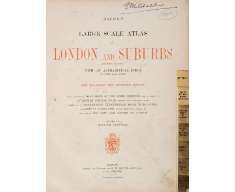
Lot 226
Bacon (G. W., publisher). Bacon's Large Scale Atlas of London and Suburbs (Revised Edition) with an Alphabetical Index, circa 1910, title page and contents list, 26 double-page and folding social, geographic and industrial maps and a 34-sheet map of Greater London, slight spotting and occasional closed tears, marbled endpapers, publisher's cloth gilt, stained, frayed and worn, folioQTY: (1)
-
216134 item(s)/page