We found 186094 price guide item(s) matching your search
There are 186094 lots that match your search criteria. Subscribe now to get instant access to the full price guide service.
Click here to subscribe- List
- Grid
-
186094 item(s)/page


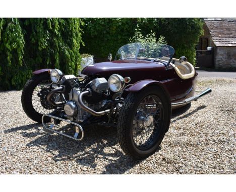
Lot 5
A 2015 Triking tourer, registration number R121 OUS, maroon. Triking, founded by Tony Divey as an independent sports car manufacturer in the old school tradition, is celebrating its 40th anniversary this year. Inspired by the Aero engined three wheel sports cars of the 1920s and 30s the Triking cars offer a scintillating performance. As with all other small scale bespoke vehicles, each car is individual and has its own character. This fine example we have the pleasure of offering for auction has been built by a retired engineer to a high standard. Since completion, the Triking has only covered a modest 500 miles. Finished in maroon with a cream leather interior with wood rim steering wheel and dashboard, its weather equipment consists of a tonneau cover. The Triking is powered by a 1064cc V-Twin Moto Guzzi engine which endows the three wheeler with exhilarating performance. The Triking will be offered with a history file and offers tremendous value at a very competitive price when compared to a contemporary modern three wheel Morgan. V5C, ***MOT to July 2019 (not August 2019)*** See illustrations
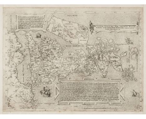
Lot 136
Lily (George), Britanniae insulae quae nunc Angliae et Scotiae regna continet cum Bibernia adiacente nova descriptio, Rome, 1558, uncoloured engraved map with the Sebastiano de Re da Chioggia imprint, orientated to the west with Ireland in the north, two panels with Latin text describe Ireland and Britain with a third containing the title, borders trimmed with new margins added, 400 x 550 mm R. W. Shirley. Early Printed Maps of the British Isles, 1477 - 1650, 63. This map is a close copy of the first separately printed map of the whole of the British Isles produced twelve years earlier by George Lily. Its overall scale is reduced by about a third from the 1546 state. The outline of England and Wales is based on a map of 1540 by Sebastian Munster. Many more place names and distinct topographical features are included. Ireland is still largely shapeless but Scotland is depicted with remarkable accuracy. This precise geographical depiction of Scotland is possible because Lily was able to consult a map of Scotland drawn by John Elden and presented to Henry VIII in 1538. Elden is known to have been in Rome in 1538. It is also possible that Lily had access to Hector Boece's Scotorium Historiae and a map thought to have been made by Alexander Lindsay while accompanying James V of Scotland of a tour of the kingdom. A striking feature of this map is that it uses distinctive and conventional signs to show county capitals and towns and the status of archepiscopal and episcopal sees. Oddly neither Oxford, Gloucester or Peterborough are marked as an episcopal see even though they were made so between 1541 and 1542. Shirley speculates that this omission could suggest that a pre 1541 map was used as a source, but could also betray the author's reluctance to acknowledge the newly created sees in light of the recent conflict between Rome and the English Crown. A rare map in remarkably good condition. (1)
![*Speed (John), The Kingdome of Great Britaine and Ireland, 1st edition, John Sudbury & George Humble, [1611], hand coloured e](https://cdn.globalauctionplatform.com/bc31b7f5-f407-4392-997f-a94400dd2197/afbc188f-182f-49dc-8777-9723c3df1fe3/468x382.jpg)
Lot 139
*Speed (John), The Kingdome of Great Britaine and Ireland, 1st edition, John Sudbury & George Humble, [1611], hand coloured engraved map, inset town prospects of London and Edinburgh, inset map of the Orkney Islands, compass rose, strapwork cartouche and mileage scale, central fold professionally repaired on verso, 385 x 515 mm, mounted, framed and double glazed, English text on verso R.W. Shirley. Early Printed Maps of the British Isles, 1477 - 1650, 316. Fine copy. (1)
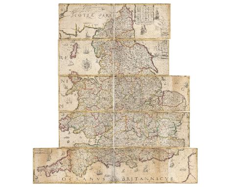
Lot 143
Lea (Philip), Untitled map taken from Christopher Saxton's large scale map of England and Wales first published in 1583, published by Philip Lea, Globemaker at ye Atlas and Hercules in Cheapside nere the corner of Fryday Street in London, [1687 - 1700], engraved map with contemporary outline colouring on ten sheets (complete), half and full compass rose, the sea decorated with numerous sea monsters and sailing ships, two mileage tables and a table of the longitude and latitude of the principal towns and counties, some restoration on the verso, to old folds, marginal closed tears and slight fraying, overall size 1415 x 1325 mm (width shown at widest point), R. W. Shirley. Early Printed Maps of the British Isles 1477 - 1650, 137, state 5. Christopher Saxton published his twenty sheet wall map in 1583. It was re-issued by Cade & Morgan in 1678. Philip Lea acquired the copper plates in about 1685 and re-published the map on a smaller scale designed to be used as a travelling map. He reduced the map to ten full sheets and four half sheets and removed a great deal of the sea, thus making the map relevant to land based travellers. The map - if partially conjoined - was pasted into five horizontal strips. The top three sheets made up of two sheets and the last two sheets made of two sheets with a half sheet pasted at each end. On this example the half sheets are attached. Philip Lea re-engraved the plates at least five times during his period of ownership. This example is his 5th and final state and therefore state 7 of a total of nine states. Lea moved from Poultry to Cheapside in 1687 and remained there until 1700. Following Lea's death, Anne his widow, re-engraved and re-issued the map with Richard Glynne in 1720 and Thomas & John Bowles & Son repeated this in 1758. Scarce. (1)

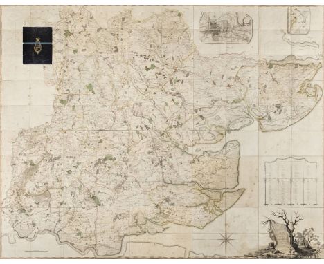
Lot 154
Dickinson (John). A new and correct map of the south part of the County of York by actual survey, shewing the true situation of the several towns, noblemen's and gentlemen's seats; the course of the rivers and rivulets, present roads, Roman ways, castles, ancient abbeys & priorys, parks, woods, hills, lakes, collieries and other minerals. Taken at the cost of the most Honble. Thomas Marquess of Rockingham..., 1750, large scale uncoloured map on two unconjoined sheets engraved by Richard Parr, large strapwork and floral cartouche, compass rose, table of towns and villages, additional cartouche containing an explanation of the map, two long repaired tears on right hand margin and one on the left hand margin, slight creasing and spotting, some fraying to margins, overall size 840 x 1230 mm Eden, Dictionary of Land Surveyors, page 84. Worms and Baynton-Williams, British Map Engravers, page 514 (but map not listed). Imago Mundi 19 (1965) page 56 - 67. Rare. We can find only one institutional copy (British Library). The production of the map was financed by Charles Watson-Wentworth, Second Marquis of Rockingham (1730 -1782), who stipulated that the map was to be reserved "For the Marquis's use and not to be sold" (see J. B. Harley 'The re-mapping of England 1750 - 1800). This would explain the map's rarity as it was never commercially available. (1)
Lot 157
Chapman (John, and Andr‚, Peter). A Map of the County of Essex from an actual survey made in MDCCLXXII, MDCCLXXIII and MDCCLXXIV by John Chapman and Peter Andr‚, [1770 or later], large scale engraved map with contemporary outline colouring, sectionalised and laid on linen, on four sheets, large compass rose, list of subscribers, inset plan of Harwich Harbour and map of Colchester, slight offsetting and browning, each sheet approximately 1140 x 1450 mm, contained in a contemporary morocco gilt box with lid, gilt crest of Charles Stanhope, 3rd Earl of Harrington, slight wear to extremities Provenance: Charles Stanhope, 3rd Earl of Harrington (1753-1829) served with British forces in North America and the Caribbean during the American War of Independence. He was also a politician, being elected MP for Thetford in 1774 and for Westminster from 1776 to 1779. Chapman and Andr‚'s meticulously detailed and accurate survey of Essex resulted in the finest large-scale map of the county. It was the first to depict minor roads, and included every country house and cottage, milestone, bridge, turnpike, creek, ferry, cliff and even duck decoy. It is unlikely that more than 300 copies of the first edition were sold, though there was a second smaller edition issued in 1785. (1)

Lot 163
Depping (George Bernhard). L'Angleterre ou description historique et topographique du Royaume Uni de la Grande-Bretagne..., 6 volumes, Paris, Etienne Ledoux, 1824, engraved title and additional half title to each volume, folding contents list and decorative engraved scale, folding map of the British Isles and fifty-eight engraved maps (complete) with contemporary outline colouring, fourteen engraved topographical views and an engraved plate of music, partially uncut, very occasional spotting, fore-edges untrimmed, contemporary boards, some wear, 12mo (6)
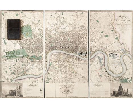
Lot 164
Greenwood (C. & J.). Map of London from an actual survey made in the years 1824, 1825 & 1826..., Greenwood, Pringle & Co., 1st edition, August 21st 1827, fine large scale map with contemporary hand colouring on three sheets, engraved by James and Josiah Neele, sectionalised and laid on linen, calligraphic cartouche, table of explantion, inset views of Westminster Abbey and St. Pauls, dedication to George IV, edged in green silk, marbled endpapers, overall size approximately 1255 x 1875 mm, contained in a contemporary green morocco gilt book box, all edges gilt, very slight wear to extremities Howgego, Printed Maps of London 1553 - 1850, 309, state 1. The Greenwood brothers Christopher and John spent three years preparing this remarkable new survey of London, prepared on the lavish scale of 8 inches to a mile, illustrating for the first time the planned development of Belgravia by Thomas Cubidt, the completion of the Grand Surrey Canal and Regent's Park one year before it was completed in 1828. (1)

Lot 165
Teesdale (Henry). To the Nobility, Gentry & Clergy of Yorkshire, this Map of the County constructed from a Survey commenced in the Year 1817 & corrected in the Years 1827 & 1828 is respectfully dedicated by the proprietors, Henry Teesdale & Co. and C.Stocking, April 21, 1828, uncoloured engraved large scale map on nine sheets, calligraphic title, list of the altitudes of the principal mountains, compass rose, table of explanation and an engraved vignette of the North west view of York Cathedral, slight offsetting, book plate of R. H. Johnstone, marbled endpapers, contemporary marbled boards, later red half morocco, contemporary red gilt morocco title label to upper board, slim upright folio (1)

Lot 166
Swire (William, and Hutchings, William). A Map of the County Palatine of Chester, divided into hundreds & parishes from an accurate survey, made in the years 1828 & 1829, Henry Teesdale, 1830, large scale engraved map with bright contemporary hand colouring, sectionalised and laid on linen, calligraphic title, compass rose, table of reference and an uncoloured vignette of the south west view of Chester cathedral, edged in green silk, marbled endpapers, 960 x 1320 mm, contained in a modern blue cloth solander box with a red gilt morocco label to upper board (1)
Lot 84
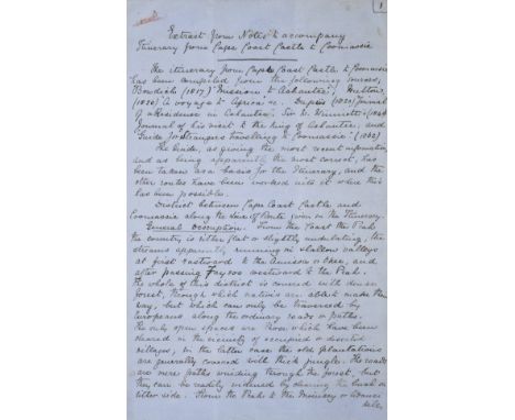
*Wolseley (Garnet Wolseley, 1st Viscount, 1833-1913). Original manuscript briefing notes entitled 'Extract from Notes to accompany Itinerary from Cape Coast Castle to Coomassie', drawn up by Lieutenant John Frederick Maurice, Royal Artillery, Private Secretary to Wolseley during the Ashantee Campaign of 1873-74, and one of the founder members of Wolseley's 'Ashantee Ring', dated 27 September 1873, comprising 11 handwritten pages on six folio sheets of blue official army notepaper, incorporating a pen and ink map of the Ashantee capital, Coomassie, signed with initials 'J.M. Cape C.C.E.' (Cape Coast Castle Expedition), accompanied by a watercolour sketch of the cape coast castle from the seaward side by acting Lieutenant (later Admiral) James Stoddart, Royal Navy (1827-1892), watercolour on card, pencil inscription to verso 'Cape Coast Castle, Admiral Stoddart, as Lieutenant, 1836', 18.5 x 26cm A surprise attack on the British Gold Coast Protectorate by the Ashantee King took place on 22nd January 1873. Months of sporadic violence followed, which the resident British forces - a battalion of the West India Regiment and one hundred Royal Marines - barely managed to contain. A punitive expedition was dispatched from England under the command of Major-General Garnet Wolseley, who embarked for the Gold Coast aboard the SS Ambris with an advance part of thirty-five staff officers, from Liverpool on 12th September 1873. Wolseley and his officers landed at the Gold Coast Castle on 2nd October 1873. This draft plan of campaign was drawn up by Lieutenant Maurice while Wolseley was at sea, being dated just five days prior to their disembarkation at Cape Coast Castle. Arriving, by design, well in advance of the main body of his force, which did not arrive until January 1874, Wolseley had a detailed plan, based on Lieutenant Maurice's comprehensive notes, in place by the time his troops arrived. After citing the various published and written sources used when drawing up the plan of campaign, including Bowdich's Mission to Ashantee (1817), Hutton's A Voyage to Africa (1820), Dupuy's Journal of a Residence in Ashantee (1820), Commander William Winniatt's Journal of his visit to the King of Ashantee (1848) and the Guide for Strangers traveling to Coomassie (1862), the notes provided General Wolseley with a detailed account of the country between the coast and the Ashantee capital, its peoples, towns and villages (with estimates of population), the jungles, rivers and swamps, climate and potential for obtaining supplies during an advance; Maurice details five different potential routes from the coast to Coomassie (7 pages of the text), outlining potential difficulties, whether the land to be crossed might prove friendly or hostile, the total distance covered by each route, along with a copied map of the Ashantee capital, taken from Bowditch, at a scale of 400 paces to the inch, indicating the position of the principal buildings and locations in the city, including Aboosaywe, or place of execution, the palace, temple, etc, and the various types of terrain in the immediate vicinity of the capital; swamp, ground cleared but rocky, yam garden, etc, as a guide to selecting the best route for the final attack. Five routes are proposed: one from the River Prah through Kairokou, Eusaguesu, Abbatea and Biaqua to Coomassie, Maurice noting with regard to this route that as the tribes to the west of Elminia have revolted, this route leaves the left flank of the line of communication so exposed that it would seem madness; a second route from the Cape Coast Castle via Anamaboe, which Maurice describes as being too difficult and dangerous; a third route from Accra to Aguieso across the rivers Birrimo, Auinee and Boosim-Prah, described as having the advantage of starting from Accra, as a base the most healthy place on the coast and well within British territory; a fourth route from Accra, passing to the north of the proposed route 3; and a fifth route to Coomassie via the River Volta, which Maurice notes as only being practicable if the river was navigable when the campaign commenced. Wolseley was able to complete the campaign successfully in only two months, evacuating his troops before the malarial wet season arrived. The plan of campaign that Wolseley put into action was essentially an amalgam of the first two options proposed by Maurice, described respectively as madness and difficult and dangerous, Wolseley overcame the problems these two routes presented by negotiating agreements with the previously hostile tribes on the left flank of his line of attack, and recruiting them to actually assist in the invasion of the Ashantee kingdom that had been previously oppressing them. The problem of passing large numbers of troops through dense jungle along narrow tracks and roads was overcome by splitting his attack into four columns, constructing an advance jumping off point in the interior at Prahsu, approximately fifty miles from Coomassie, from which the main column attacked along the Prahsu - Coomassie road, supported by the three flanking columns, and converging on Coomassie for the final assault. Captain (later Major-General Sir) John Frederick Maurice (1841-1912) obtained material and information from a wide variety sources, including Admiral James Stoddart, from whom he obtained this watercolour showing the location and strategic importance of the Cape Coast Castle, which became the base for operations during the Ashantee campaign. (2)
Lot 144
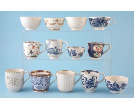
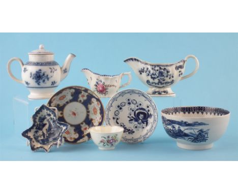
Eight Worcester cups and five tea bowls circa 1770 - 1790, painted with Mansfield, Kempthorne, Rock Strata, patterns as well as printed with Three Flower, Birds in Branches, Fence and Royal Lily patterns, an interesting blue scale cup probably outside decorated, two coffee cups and a tea bowl have reeded bodies, two tea bowls are moulded with reeding (13) The largest cup stands 6.5cm high For a condition report on this lot visit www.peterwilson.co.uk
Lot 161
Collection of Pearlware circa 1780-1800, to include a feather moulded sauce boat, a saucer, low Chelsea ewer shape cream boat painted with polychrome flowers, a teapot, a blue scale saucer after Worcester, a pickle dish, bowl printed with Fisherman and Cormorant pattern after Worcester, also a creamware bowl painted with floral sprays, (10) the plate measures 19.5cm wide For a condition report on this lot visit www.peterwilson.co.uk
Lot 664
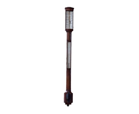
A second half of the 19th century mahogany barometer by C.W Dixey , London (New Bond Street), 'Optician to the Queen'. The ivorine forecasting dial has domed glass cover and scale vernier with mercury gauge. Column set with ivorine thermometer and ebonised vase shaped cistern cover to base. Length 94cm. For a condition report on this lot visit www.peterwilson.co.uk


![Mercator, G.; Jansson, J. Gallicia Legio, et Asturias de Oviedo. Amsterdam, [c.1628]. Sometime hand-coloured. From the Atlas](https://cdn.globalauctionplatform.com/db6b26b8-b86f-48f9-a1c6-a92900aa3753/6f86682a-4a9b-468d-9a89-16426246698a/468x382.jpg)
Lot 135
Mercator, G.; Jansson, J. Gallicia Legio, et Asturias de Oviedo. Amsterdam, [c.1628]. Sometime hand-coloured. From the Atlas Minor, a 'pocket-sized' version of the larger Mercator Atlases, it was nonetheless larger than other pocket atlases of the time, allowing for greater detail. This can be seen in the number of topographical features on the map. Mercator/Jansson Eboracum, Lincolnia, Derbia, Staffordia, Notinghamia, Lecestria, Rutlandia, et Norfolcia. [c.1650]. Sometime hand-coloured. From the Atlas Minor, with unusual monument distance scale. Mercator/Jansson Insula Zeilan, olim Taprobana, nunc Incolis Tenarisim. [c.1650]. Sometime hand-coloured. A rare map of Sri Lanka added to the Atlas Minor for Jansson's German 1648 edition. It only appeared in two editions. Highly detailed, marking villages, mines and spice plantations. Hondius, J.; Purchas, S. Ceilan Insula. London, [n.d. but likely 1625]. Sometime hand-coloured. This version of the Mercator Atlas Minor map was published in Samuel Purchas' His Pilgrimes, a seminal 17th century collection of voyages first published in 1625. Purchas drew on manuscripts collected by Hakluyt to create the largest book ever published in England. The first edition contained nearly 90 maps, some of which were completed by Jocodus Hondius. Hondius (Joost de Hondt) reprinted Mercator's Atlas after his death adding 36 maps. Hondius released the Atlas under Mercator's name, aiding his sales and boosting Mercator's reputation posthumously. After 1633 his son-in-law, Johannes Janssonius, was listed as co-publisher.

Lot 76
Leighton, Clare The Farmer's Year. Collins, 1933. Oblong folio, org. cloth, in unclipped dj; 12 woodcut plates, each month with decorative initial capital and 6 with woodcut tail-piece. idem. Four Hedges. A Gardner's Chronicle. Victor Gollancz, 1935. 8vo, org. cloth, in unclipped dj; numerous woodcut illus. by Leighton. idem. Country Matters. Victor Gollancz, 1937. 8vo, org. cloth, in dj; numerous woodcut illus. by Leighton. Illustrator and writer Clare Leighton was best known for her wood engravings. During the 1920s and 1930s, as the world around her became increasingly technological, industrial, and urban, Leighton portrayed the vanishing lives of rural working men and women. Contemporaries like Sir John Squire praised her work, Eric Gill saying that ''...no one in our time has succeeded better than Clare Leighton in presenting the noble massiveness and breadth of the life of the earth on a scale so grand.'' idem. The Musical Box. Gollancz, [1936]. Oblong 4to, org. boards, decorative endpapers; coloured illus.Jacket dulled and torn, with some loss to foot of spine, board edges sunned, also foot of spine where jacket lost, however apart from occasional very slight foxing and a couple of margins a touch dusty, a clean copy internally. Four hegdes dj spine faded, edges a little creased and torn, light foxing to jacket but despite slight, occasional, marginal foxing throughout a clean, bright copy internally. Country Matters dj has tear in lower corner of upper panel, spine faded with rubbing and creasing to edges, foxing of endpapers but internally clean. Musical Box boards used with tearing to head of spine, very slight marginal foxing but bright internally.


Lot 151
Sorna, ref. 2655, a stainless steel wristwatch, circa 1975, Swiss manual wind chronograph movement, 17 jewels, blue dial, baton markers, tachymeter scale, baton hands, centre chronograph hand, subsidiary dials for constant seconds and 15 minute recording, date aperture at 3 o’clock, screw down back, case, dial and movement signed, on an unsigned black leather strap, width 39mm
Lot 152
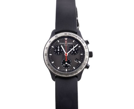
Porsche Design by Eterna, ref. 6610.14, a black coated aluminium and titanium wristwatch, Swiss quartz chronograph movement, 27 jewels, cal. ETA 251262, grey dial, luminous baton markers, luminous baton hands, centre chronograph second and minute recording hands, subsidiary dials for constant seconds, 1/10th second and 12 hour recording, tachymeter scale to the bezel, screw down crown, screw down back, case and dial signed, on a Porsche Design black rubber strap with a deployant clasp, diameter 39mm
-
186094 item(s)/page