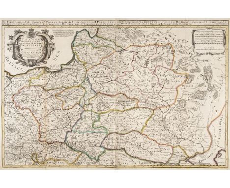

Poland. Bowles (John), Poland Subdivided according to the extent of its Severall Palatinates, circa 1744, engraved map with contemporary outline colouring, large uncoloured cartouche, additional title above map, old folds, short splits to old folds, folds strengthened on verso, 570 x 860 mm (Qty: 1)NOTESRare unrecorded state of William Berry's two sheet map of Poland originally published in about 1683 in London. William Berry's map of Poland was the first large scale map of Poland to be published in England and whilst the map credits Nicholas Sanson's earlier map as its source the map is actually drawn from Hubert Jaillot's map of Poland published about ten years earlier in Amsterdam. The first edition has a dedication to Charles II whereas this edition acknowledges the present king, George II. The scarce second state bears the publishing imprint of Thomas Taylor, Philip Overton and John Lenthall. We have been unable to locate another example of this map and this example was catalogued by Ashley Baynton Williams for the London Antiquarian Book Fair of 2013.
We found 216136 price guide item(s) matching your search
There are 216136 lots that match your search criteria. Subscribe now to get instant access to the full price guide service.
Click here to subscribe- List
- Grid
-
216136 item(s)/page
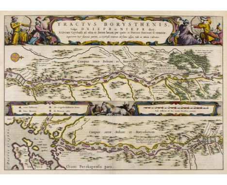
River Dnieper. Blaeu (J.), Tractus Borysthenis vulgo Dniepr et Niept dicti a Civitate Czyrkassii as ostia Ilmien lacum per quem in Pontum Euxinium se exonerat..., [in set with] ...., à Kiovia usque ad Bouzin..., [and] à Bouzin usque ad Chortyca Ostrow..., [and] ..., à Chortika Ostro ad Urbem Oczakow ubi in Pontum Euxinum se exonerat, Amsterdam, [1662 - 1665], set of four engraved maps with bright contemporary outline colouring showing the course of the River Dnieper, each with an elaborate and decorative cartouche and mileage scale, each approximately 390 x 540 mm, Latin text on verso (Qty: 4)NOTESPublished in the 'Atlas Maior'.
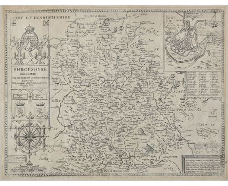
Shropshire. Speed (John), Shropshyre described, The Sittuation of Shrowesbury Shewed with the Armes of thos Earles and other memorable things observed, Dicey & Co, circa 1770, uncoloured engraved map, large strapwork cartouche and mileage scale, inset town view of Shrewsbury, slight mount staining, laid on linen, 385 x 505 mm (Qty: 1)
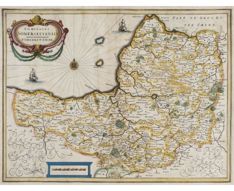
Somerset. Jansson (Jan), Comitatus Somerettensis Somerset-Shire, circa 1638, engraved map with contemporary hand colouring, ornate strapwork cartouche and mileage scale, compass rose and numerous rhumb lines, slight staining, 385 x 510 mm, Dutch text on verso, together with Collinson (John). A Map of the County of Somerset, published C. Dilly, 1792, hand coloured engraved map originally published in Collinson's ' The History and Antiquities of the county of Somerset, collected from authentick records..., ', old folds, some weakness where old folds cross, one area of crude repair on verso, 480 x 630 mm, with Morden (Robert). Somersetshire, [1695], engraved map with contemporary outline colouring (it is rare to find Morden's maps with contemporary colouring), 360 x 425 mm, plus Slater J & Pigot (James). Somersetshire, circa 1857, engraved map with contemporary outline colouring, uncoloured vignette of Wells Cathedral, 240 x 360 mm (Qty: 4)NOTESThe first described item is in the scarce 'pre-atlas' state printed before the addition of the six coats of arms and a re-working of the title cartouche.
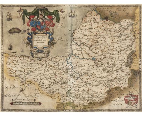
* Somerset. Saxton (Christopher), Somersetensem Comitat (agri fertiltate celebrem) hec ob oculos ponit Tabula. Anno 1575. et D. Elizabethe Regine Ao 17, [1579], engraved map with contemporary hand colouring, ornate heraldic and strapwork cartouche and mileage scale, with the arms of Thomas Seckford in the lower right corner, 395 x 520 mm, mounted framed and glazed (Qty: 1)NOTESThe first county map of Somerset.
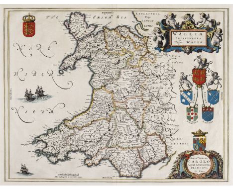
Wales. Blaeu (Johannes), Wallia Principatus vulgo Wales, Amsterdam, circa 1660, hand coloured engraved map, large decorative cartouche, 390 x 495 mm, no text on verso, together with Jansson (Jan). Principatus Walliae pars Australis vulgo South-Wales, Amsterdam, circa 1650, engraved map with contemporary outline colouring, large decorative cartouche and mileage scale, compass rose and numerous rhumb lines, repaired closed tears affecting image, slight marginal fraying, 415 x 525 mm, French text on verso, with Bertius (Petrus). Cambria, [1616- 1639], uncoloured miniature engraved map, with additional title in French above map, and French text to verso, 100 x 140 mm (Qty: 3)
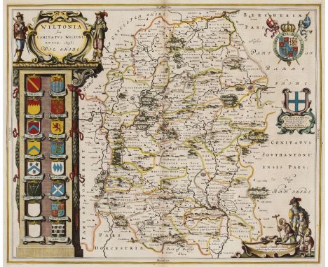
Wiltshire. Blaeu (Johannes), Wiltonia sive comitatus Wiltoniensis Anglis Wil Shire, circa 1660, engraved map with contemporary outline colouring, decorative cartouche and mileage scale, slight worming, 415 x 500 mm, Spanish text printed on a separate sheet and tipped on to verso, together with Walker (J & C). Wiltshire. Places of the Meeting of Foxhounds, published in 'Hobson's Fox Hunting Atlas', circa 1850, lithographic map with contemporary outline colouring, slight soiling, 405 x 330 mm (Qty: 2)


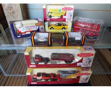
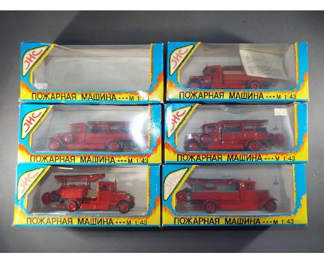
Three Trackside Days Gone diecast models, AEC Mammoth with flatbed trailer vand brick load, DG 149000, Scammell Ballast low loader & Harvard load DG 110005 and Guy Pantechnicon DG 146006, also Days Gone Showmans Scammell six wheeler, Biddall's Fun Fair DG 044034, two Gaugemaster 1:87 scale model cars, Maisto Corvette ZR1 and open top double decker London Bus, all mint in boxes (storage wear to Corvette and Bus boxes)
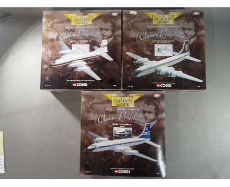
Corgi - Three limited edition 1:144 scale diecast model aeroplanes from the Corgi Aviation Archive Classic Propliners collection comprising # 48605 Bristol Britannia 314 G-ATNZ Caledonian Airways, # 48601 Bristol 175 Britannia 102 Laker Airways and # 48602 Bristol 175 Britannia 312 BOAC. Models appear M in original boxes (# 48601 appears to be lacking landing gear pieces). [3]
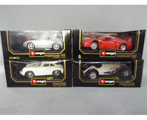
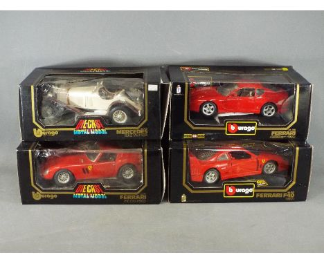
Bburago - Four boxed Bburago 1;18 scale diecast model cars. Lot consists of #3009 Mercedes Benz SSK 1928; #3032 Ferrari F40 1987; #3050 Porsche 911 Carrera 1993; #3021 Porsche 356B Coupe 1962. Models appear to be in Mint condition in Good boxes with some imperfections as loose cellophane windows. (4)
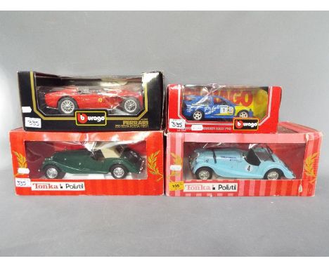
Bburago, Polistil - Four boxed Bburago and Polistil 1:18 and 1:24 scale diecast model cars. Lot consists of Polistil #01868 Morgan Plus 8; Polistil #01690 Morgan Berlinetta; Bburago #0543 Ford Escort RS Cosworth Rally 1994; #3007 Ferrari 250 Testarossa 1957. Models appear to be in Mint condition in Good boxes with some imperfections such as loose and cracked cellophane windows. (4)

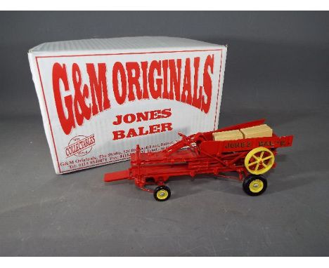
G&M Originals - A boxed 1:32 scale white metal and resin model of a Jones Baler by G&M Originals of Nottingham. The model is finished in bright red with yellow hubs and overall appears to be in Very Good condition but has some slight damage to both rear sides of the baler. This specialist model is presented in an Excellent original box complete with inner packaging, and is unchecked for completeness.
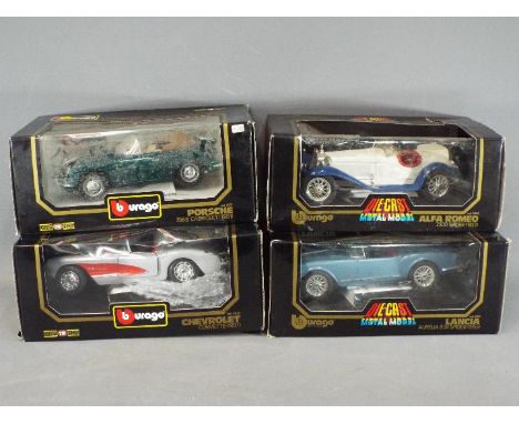
Bburago - Four boxed 1:18 scale diecast model cars by Bburago. Lot consists of # 3051 Porsche 356B Cabriolet; #3024 Chevrolet Corvette; #3010 Lancia Aurellia Spider; and #3008 Alfa Romeo 2300 Spider. Models appear to be in Mint condition in Poor - Good boxes with some imperfections and are unchecked for completeness.
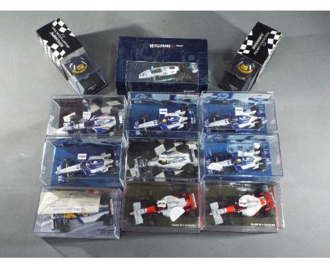
Minichamps - A collection of 10 1:43 scale diecast model F1 racing cars and 2 boxed 1:8 scale Racing Helmets by Minichamps. Lot includes Limited Edition Williams Renault FW18 Winner German GP 96 - Damon Hill; Williams FW088 Test Car 1982; Helmet Collection - Damon Hill 1996 and similar. Models appear to be in Mint condition in Very Good - Mint boxes.
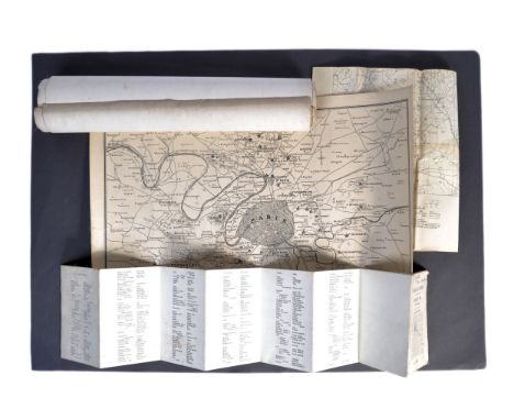
A collection of original WWI First World War Maps -.First World War Map: Belgium and France sheet 36, Lille and Armentieres, edition 6. published for the British Army by the Ordnance Survey 1915 with roads updated to January 1916. On folding linen. Size 89 by 68 cm. Scale 1:40,000. Colour. Coded GSGS 2743 to the bottom left corner. A detailed map. The front cover has the name W E Matthews of C Company, 10th Yorkshire Regiment in ink above the title. Trench Map: Watou and Houtkerque area. Belgium and France Sheet 27 NE, edition 3, published by the Ordnance Survey December 1917. Coded in bottom l/h corner GS GS 2742. On folding linen on a scale of 1:20,000. Size 89 by 65 cm. A detailed key includes information on British and enemy trenches, wire entanglements, dug-outs, huts, buried cables and pipelines etc. as well as railways, trench tramways and houses. Some wear to about 10 cm along one of the folds in the linen but no actual tear. Original owner’s name to reverse. The owner served in the Durham Light Infantry and the Northumberland Fusiliers and was wounded in France.The Times War Atlas. Published by the Times of London, no date but circa late 1914. Seven sheets of maps on linen, each 62 by 46 cm. Scales vary. They comprise: Northern France;Alsace Lorraine, Heligoland, Kiel Canal, Posen, the mouth of the Ems, and three other small maps;North Western France;Eastern Germany and Poland;Paris and environs;Western Germany;The Area of Fighting in Galicia, East and West Prussia, Posen and the Russian frontier, German South West Africa, German East Africa and Cameroon.The maps all feature various theatres of war but show no stages of the actual conflict, probably indicating that these preceded any larger bound publications by the Times during the war.
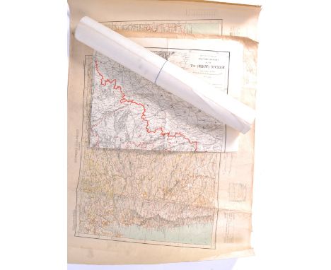
A collection of antique maps of India comprising: Map of the Peninsula of India from the 19th Degree North of Latitude to Cape Comorin by James Wyld, published by Wyld London 1824. On paper size 80 by 56 cm. Scale 20 miles to the inch, with five other scales including Mogully Coss, Royal Coss and Punjabi Coss. Map includes most of Sri Lanka. Heights indicated by shading or hachuring. Was originally colour coded to show the possessions of the various European powers but little colour remains. Occasional foxing to one sea area. Some tears to the margins outside the map have been closed to the reverse with archival quality tape. Survey of India Map: Koko Nor, with parts of China and Tibet. Published by the Survey of India, Calcutta 1926 from an original survey in 1893. On linen size 69 by 62 cm. Scale 1:2,000,000. Stamped “for official use only”. Includes part of the Great Wall. The main town shown is Lauchowfu. Key includes information on roads, boundaries and various railway gauges. Some colour. 2 copies Map of Bombay region. Published by the Survey of India, Calcutta 1926. On paper size 81 by 64 cm. Scale approximately 32 miles to the inch. Colour. Shows British, French and Portuguese possessions. Includes Bombay, Central Province, Hyderabad etc. With a colour coded key to items such as the various railway gauges etc. 3 copies Map of North West India. A Map to Accompany Military Report on the Vth (MHOW) Division. On paper size 93 by 74 cm. Published by the British Army in India circa 1905. On paper size 93 by 74 cm. Scale 32 miles to the inch.
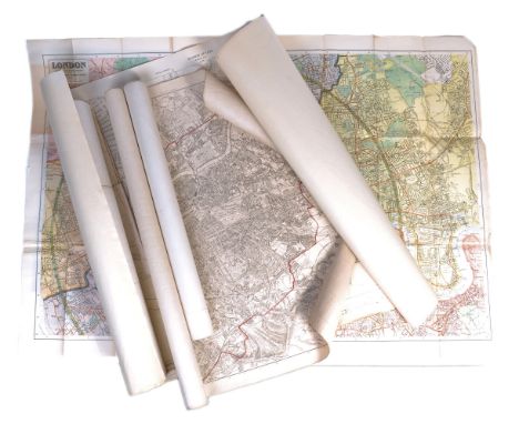
A collection of five Maps of London: Kelly’s Map of London drawn and engraved expressly for the Post Office Directory 1884. On linen size 99 by 73 cm. Scale 3 inches to the mile. Has been rolled. With a key to boundaries of postal districts, counties and county court districts. A detailed map. Kelly’s Map of London drawn and engraved expressly for the Post Office Directory 1893. On paper size 108 by 76 cm. Scale four inches to the mile. Colour. Covers an area from Cricklewood in the north west across to Leyton and from Parsons Green in the south across to Greenwich Park in the east. A detailed map. The prison at Millbank has gone and the site shown as empty and ready for development. Kelly’s Map of Middlesex. Published by Kelly, London circa 1880 for their Post Office Directory. On folding linen size 98 by 66 cm. Scale one inch to the mile. With a key to features including railways, canals, rivers, churches, the boundaries of the hundreds and the representation of the county in parliament. Plus a large 25-inch to the mile OS map of Enfield and an early OS map of East London and the Thames Estuary circa 1845.
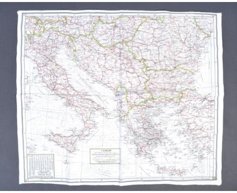
An original WWII Second World War related silk ' escape ' map of Crete and Italy. Double sided, the map printed on silk. Dated to 1940 / 1941. Scale 1:1,750,000. Folded. Measures approx; 61x52cm. During World War II, the United States and Great Britain produced in excess of 3.5 million silk maps and cloth maps for Allied military personnel to use as escape maps. In 1940, the British military intelligence unit, known as MI 9, started issuing silk maps for use by British aircrews shot down over enemy occupied territory in Europe. The silk maps were intended to assist airman in evading capture. MI 9 also smuggled silk and tissue paper escape maps into POW camps in Germany along with other escape aids to encourage POWs to attempt escape. From the collection of the late Arthur Muggeridge - Arthur T. Muggeridge, born 18th December 1919 - it’s thought he spent most of WW2 in the Royal Artillery and was at Dunkirk in 1940 during the evacuations and was minorly injured by Luftwaffe bombing whilst on one of the navy ships. He later took part in a special raid called Operation Claymore 4th March 1941 in Norway where he was injured once again in the leg by shrapnel. Later again, he was injured a third time when a field artillery gun misfired causing deafness which is believed to have resulted in him being discharged from the military. In his later life he collected mainly military items and particularly spy / clandestine objects. Whilst visiting Devon in the 1960's he became acquainted with Charles Frazer Smith who had worked for MI6 & MI9 in the war, and designed spy items for the SOE and others. Arthur died aged 91 after a short illness on 27th Feb 2010. His amassed collection is now being offered for sale by his family.
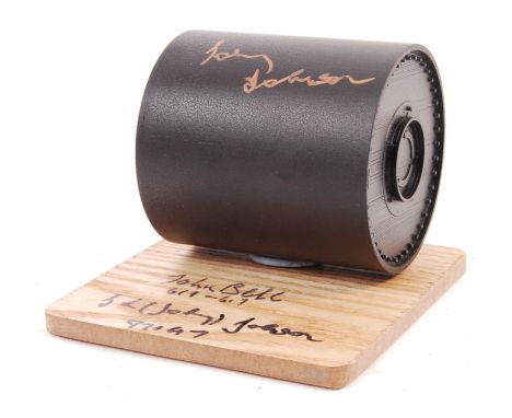
A rare Dambusters WWII Second World War large scale replica model of ' Upkeep ' aka 'The Bouncing Bomb' as designed by Barnes Wallis for use on the famous Dam Buster missions of the war. Autographed to the front in gold pen by last surviving Dambuster and AJ-T Bomb Aimer George 'Johnny' Johnson. With display plinth, also signed by Johnson and 617 Squadron Bomb Aimer John Bell. The model measures approx; 3" long. 1 of only 2 ever made. Rare.
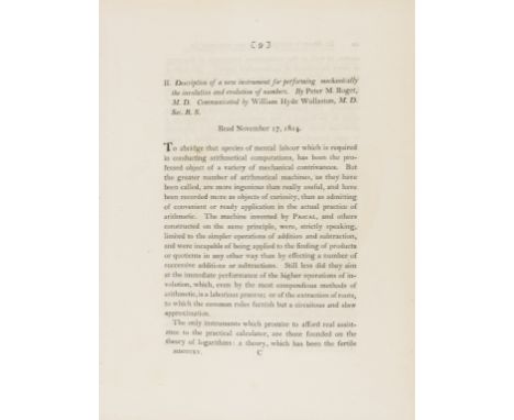
NO RESERVE Roget (Peter Mark) Description Of A New Instrument For Performing Mechanically The Involution And Evolution Of Numbers, extract from "Philosophical Transactions of the Royal Society of London", vol. 105, pp.9-28, 3 engraved plates (2 folding, 1 trimmed at outer margin), disbound, [Tomash & Williams R104], 4to, [1815].⁂ "It was Roget who invented the concept of the log-log scale that was later universally adopted as one of the standard scales on a slide rule. Its value was not immediately appreciated because the need for this scale only became apparent when various formulae, containing non-integer exponents in thermodynamics were developed. Roget's scale was forgotten, and various unwieldy schemes were proposed for handling the until Roget's scale was rediscovered in 1901." - Tomash & Williams.
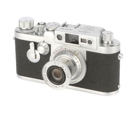
A Leica IIIg Rangefinder Camera, 1960, chrome, serial no. 987804, with Leitz Elmar f/3.5 50mm red scale lens, 1956, chrome, serial no. 1373050, body, VG-E, shutter working, lens, VG-ENotes: From last batch of IIIg production October 1960Note: VAT due on the hammer price at 5% and buyer’s premium at 20%
-
216136 item(s)/page