Dominic Winter Auctions
Lot 350
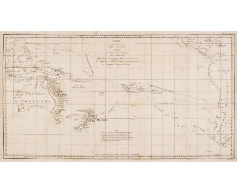
Australasia. Cook (Capt. James & Benard Robert), Carte d'une Partie de la Mer du Sud Contentant les Decouvertes de Vaisseaux de sa Majesté le Dauphin, Commodore Byron, la Tamar, Capitne. Mouats, 1765, Le Dauphin, Capitne. Wallis, le Swallow, Capitne. Cartaret, 1767, et l'Endeavour, Lieutenant Cook 1769, [1774], uncoloured engraved chart of the Southern Pacific Ocean, originally published in a French edition of 'An Account of the Voyages..., in the Southern Hemisphere' old folds, some staining, 360 x 665 mm, together with Le Perouse (Comte Jean de). Carte d'une Partie du Grande Océan a l'E et S.E. de la Nouvelle Guinee..., 1781, uncoloured engraved chart, showing the coastline of North-Eastern Australia, New Guinea, Fiji, Samoa & Tonga, slight creasing, some water staining but confined to the margins and not affecting the printed image, 345 x 495 mm, with Reinecke (Johann Matthais Christoph). Charte von Australien Berichtigt im November 1812, Prague, 1815, engraved map with contemporary outline colouring, old folds, slight staining, three very small holes where old folds cross, bound with eleven uncoloured engravings of Australasian mammals, birds, native costume and costume, several with long closed tears, plus an untitled map of Australia (part of a large scale map) with contemporary outline colouring, with two inset maps of King George III Sound and The Discoveries made by the Ship Duke on the Southern extremity of New Holland, 1791, slight creasing, 430 x 605 mmQty: (4)