We found 216134 price guide item(s) matching your search
There are 216134 lots that match your search criteria. Subscribe now to get instant access to the full price guide service.
Click here to subscribe- List
- Grid
-
216134 item(s)/page


Lot 11
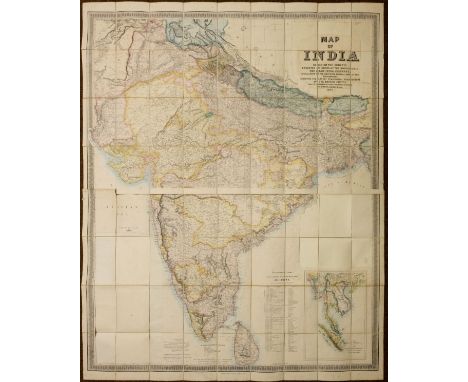
Stanford (Edward, publisher). Map of India, based on the surveys executed by order of the honorable The East India Company, special maps of the surveyor general and other authorities; showing the latest territorial acquisitions of the British Empire and the independent and protected states, railways, canals, &c., 1857, large-scale lithographic map on two sheets, with contemporary outline colouring, inset map of the Malay Peninsula, sectionalised on linen, the title cartouche to upper right excised, and laid back down on later backing paper, with loss of the circular decorative border and similar excision of the three circular distance and bearings charts to lower left and to centre right, overall size 1500 x 1230 mm, contained in contemporary cloth slipcase with printed label to upper cover, rubbed and minor fraying to extremities, some water staining to upper cover (Qty: 1)NOTESSold as seen, not subject to return.
Lot 111
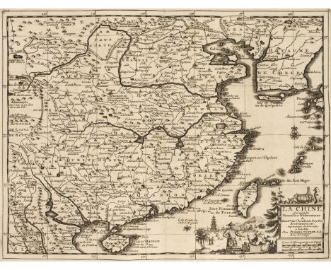
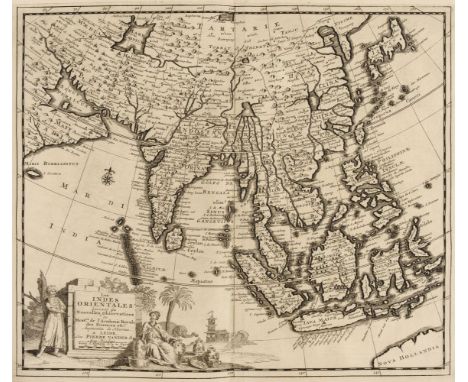
East Indies. Van der Aa ( Pieter ), Les Indes Orientales suivant les Nouvelles Observations..., circa 1720, uncoloured engraved map,decorative cartouche and mileage scale, wide margins, 285 x 340 m (Qty: 1)NOTESDetailed map of South East Asia, Japan, Korea, India and the tip of Australia in the lower right. The map is centered on the Ganges and extends from Japan, the Philippines and the Moluccan Islands to the Persian Gulf and Indian Ocean.
Lot 123
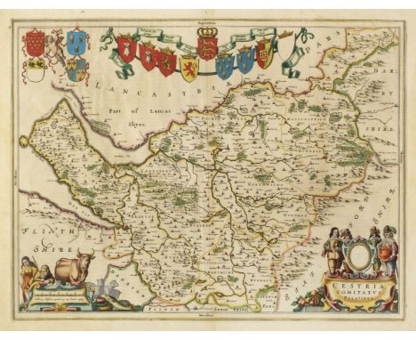
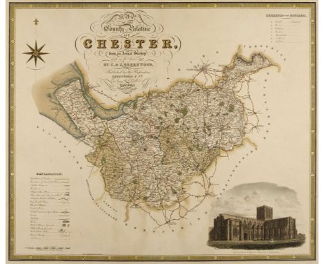
Greenwood (C. & J.). A collection of eleven county maps, circa 1830, engraved maps, eight with contemporary hand colouring, some toning and staining, one map trimmed to neatline and crudely re-margined with later paper, some marginal chipping and tears with occasional loss, one laid on hardboard, occasional duplicates, each approximately 585 x 700 mm, together with Hodgson (Thomas). Plan of the County of Westmorland, Describing minutely the Boundaries of Wards, Parishes, and Townships ... Turnpike, Carriage, Bridle and Roman Roads, also the Positions of Towns, Villages, Seats & Farm Houses, Commons, Parks, Woods, Lakes, Mountains, &c. &c. 1828, uncoloured engraved large scale map, vignettes of Appleby and Lowther castles, calligraphic title, table of explanation, list of the heights of mountains and the depths of Lakes, compass rose and mileage scale, the map is cut into four parts, each laid on card and then the whole on to hardboard, the board is bowed, printed surface creased, dust soiled and frayed with areas of loss to the margins and upper left and right corners, 1390 x 1600 mm (Qty: 12)NOTESThe Greenwood maps comprise of :- Cheshire, Nottinghamshire, Warwickshire, Cumberland, Staffordshire, Westmorland, North East Circuit of Wales, The North West Circuit of Wales, Monmouthshire and Worcestershire (2 copies).
Lot 140
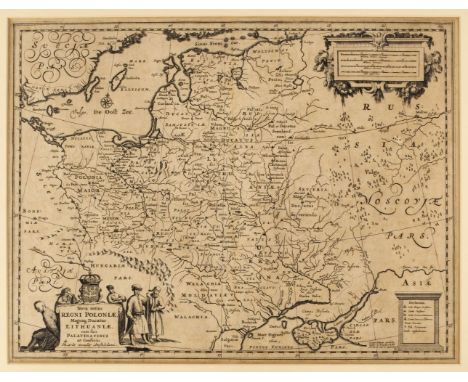
* Poland. Allard (Hugo), Nova Totius Regni Poloniae, Magniq. Ducatus Lithuaniae, cum suis Palatinatibus ac Confinis, published Amsterdam by Guillaume Le Vasseur de Beauplan, circa 1660, uncoloured engraved map, decorative cartouche and mileage scale, slight overall toning 390 x 510 mm, mounted, framed and glazed (Qty: 1)
Lot 143
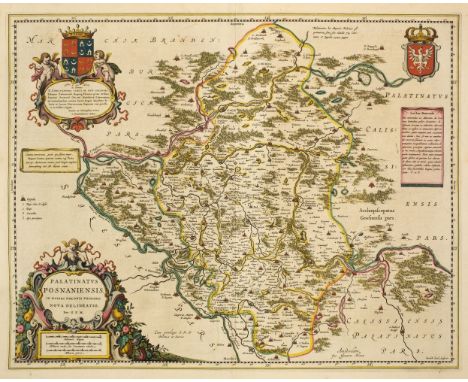
Poland. Blaeu (Johannes), Palatinatus Posnaniensis, in Maiori Polonia Primarii nova delineatio. per G. F. M. Amsterdam, circa 1670, engraved map with contemporary hand colouring, large floriate cartouche and mileage scale, 420 x 530 mm, Spanish text on verso, together with Ducatus Silesiae Giogani vera delineatio, Amsterdam circa 1640, engraved map with contemporary outline colouring, decorative strapwork cartouche and table of explanation, 425 x 510 mm, Latin text on verso (Qty: 2)
Lot 146
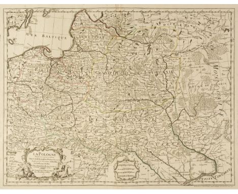
Poland. De L'Isle (Guillaume), La Pologne Dressée sur ce qu'en ont donné Starovolsk, Beauplan, Hartnoch et autres..., Paris, 1703, engraved map with contemporary outline colouring, uncoloured decorative cartouche and mileage scale, 490 x 635 mm, together with another example with later outline colouring and several areas of damage, crudely repaired (Qty: 2)
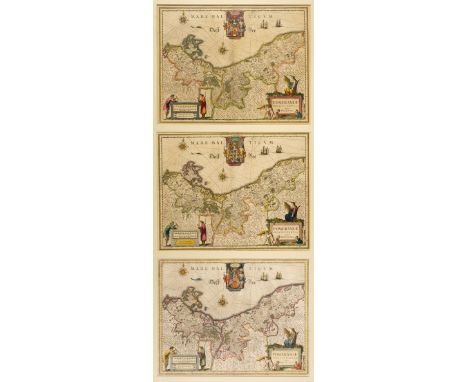
Lot 159
Poland/Pomerania. Jansson (Jan), Nova Illustrissimi ducta Pomeraniae tabula, Amsterdam, circa 1630, engraved map with contemporary outline colouring, large decorative cartouche and mileage scale, compass rose and numerous rhumb lies, occasional marginal repaired closed tears but not affecting image, 385 x 495 mm, French text on verso, together with Dankerts (Theodore). Ductas Pomeraniae Tabula Generalis in qua sunt Ducatus Pomeraniae, Stettinensi, Cassubiae, Vandaliae et Bardensis..., Amsterdam, circa 1690, engraved map with contemporary outline colouring, large decorative cartouche, some marginal finger and dust soiling, 500 x 580 mm, with De Wit (Frederick). Marchionatus Brandenburgi et Ducatus Pomeraniae tabula..., Amsterdam, circa 1680, engraved map with contemporary outline colouring, very slight staining, 490 x 565 mm, plus Rossi (Giacomo Giovanni), La Pomerania divisa in Citerioe ò Reale..., Rome 1689, hand coloured engraved map, large decorative cartouche, 435 x 555 mm (Qty: 4)
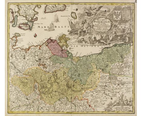
Lot 161
Poland/Pomerania. Seutter (Matthaus), Ducatus Pomeraniae cum magna Maris Balthici et Provinciarum ad Nexarum Parte..., Augsburg, 1725 - 1740, engraved map with contemporary hand colouring, very large uncoloured baroque allegorical cartouche, manuscript page number to upper right corner, 500 x 570 mm, together with Schenk (Petrus). Ducatus Pomeraniae Tabula Generalis in qua sunt Ducatus Pomeraniae, Stettinensi Cassubiae Vandalie et Bardensis..., Amsterdam, circa 1710, engraved map with contemporary hand colouring, large uncoloured cartouche, some oxidisation to old colour causing splitting and cracking to image with small areas of loss, 490 x 580 mm, with Brüggemann (Ludwig Wilhelm & Gadebusch Thomas). Special Charte vom Herzogthum Pommern nebst den angränzenden Ländern von Meclenburg der Ucker ung Neumark Westpreussen un Netzdistrict..., Nuremberg, 1702, engraved map with contemporary hand colouring, large table of explanation, title repeated in French above map, 465 x 710 mm, plus Dezauche (Jean Claude). Le Duche de Pomeranie compris sous le Cercle de la Haute Saxe divise suivant qu'il est presentement partagé entre la Couronne de Suede et L'Eslecteur de Brandebourg..., Paris, circa 1780, engraved map with contemporary outline colouring, large uncoloured cartouche and mileage scale, 465 x 655 mm, and Sotzmann (Daniel Friedrich). Der Nördliche Theil des Ober Saechsischen Kreises oder die Mark Branenburg und das Herzogthum Pommern..., Berlin [1793], engraved map with contemporary outline colouring, originally published in 'Repertorium zur Karte von Deutschland...,' 255 x 295 mm (Qty: 5)
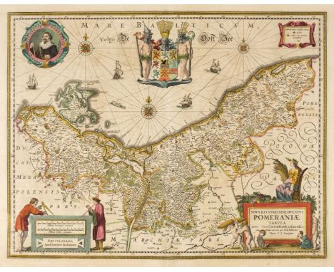
Lot 162
* Pomerania . Blaeu (Willem Janszoon), Pomeraniae ducatus tabula Auctore Eilhardo Lubino , Amsterdam, circa 1640, engraved map after E. Lubin, with contemporary outline colouring, decorative cartouche and mileage scale, compass rose and numerous rhumb lines, with two additional copies but different editions of the same map, each 380 x 490 mm, triple aperture mount, framed and glazed (Qty: 1)NOTESA highly decorative map of the area of Pomerania, in what is now present day eastern Germany and Poland . The map is dominated by the elaborate coat of arms of Pomerania. The mileage scale is supported by two figures of scholars or possibly cartographers, one wielding a pair of dividers.
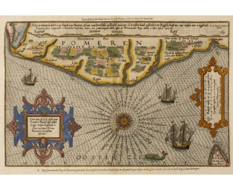
Lot 164
Pomerania . Waghenaer (L. J.), Caerte van de Zee Custe vant Landt te Pomere , also Tselfde in zijn Wessen en Gedaente is, Antwerp, circa 1600, sea chart engraved by J Van Doetecum, contemporary hand colouring with later enhancement, large strapwork cartouche and mileage scale, compass rose and numerous rhumb lines, two repaired worm holes in margin but not affecting image, 340 x 505 mm, French text on verso (Qty: 1)NOTESA Waghenaer sea chart taken from the French edition of the Mariner's Mirror. 'Le Nouveau mirroir des Voyages et Navigations'. Koeman Wag 11a
-
216134 item(s)/page