We found 186097 price guide item(s) matching your search
There are 186097 lots that match your search criteria. Subscribe now to get instant access to the full price guide service.
Click here to subscribe- List
- Grid
-
186097 item(s)/page


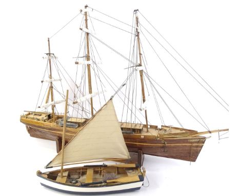
Lot 121
A Kit Based Remote control Operated 1;32nd Scale Super Detailed Extremely Well Built Model Trawler 'Maggie M', based upon the original 1990 trawler built by Campbeltown Ship Builders, detailed glass fibre hull, 50mm brass propeller, battery powered, Decaperm 12V motor, battery and receiver on switches, crystal transmitter, display plinth, photos and information sheet, finished to a high professional standard and worthy of the fullest and closest inspection, length 85cm, width 25.5cm.


Lot 243
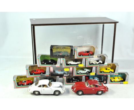
A quantity of boxed and loose model racing cars and other vehicles, the former including six Quartzo 1:43 scale touring cars, a further Ixo touring car, 1:18 scale Aston Martin DB7, numerous Vanguards and Oxford diecast examples, etc, loose including Dinky 162 Triumph 1300 and further Hot Wheels and Matchbox, also a series of class car collectors' cards with illustrations and technical details, prints depicting racing cars and drivers and two Ramsay's collectors' price guides.


Lot 236
Eight boxed 1/18 scale model cars comprising Kyosho BMW 3 Series, Gateway Global Ltd Maybach, Maisto Porsche 911 Targa, 911 Carrera 4S and 911 Speedster (1989), Burago Ferrari 456GT 1992 and Chrono Lotus Elise GT1 presentation car 1997 (8). CONDITION REPORT: Boxes worn, internal models appear ok but please judge from pictures and request more images in necessary.

Lot 813
A pair of late 19th/early 20th century Chinese Famille Rose porcelain baluster vases painted in enamels with two panels of girls on a terrace, alternating with panels of flowers, dragons, auspicious objects and birds, all on a yellow fish scale decorated ground, height 35.5cm (2). CONDITION REPORT: One vase has 2cm hairline crack from the rim showing externally and internally, general pitting and scratches throughout.


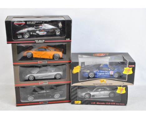
Lot 234
Eight boxed 1:18 scale Mercedes-Benz model cars comprising Vision SLR Roadster, CLK-DTM 2000 Team 24 Stunden Service, CLK-DTM 2000 Team Warsteiner, Vision SLA, CLK-GTR Meisterauto 1998 Ludwig/Zonta, Original-Teile AMG Mercedes CLK, Vision SLR Limited Edition and a further SLR (8). CONDITION REPORT: Boxes heavily worn, majority of internal models appear ok, the latter mentioned SLR in black has some visible surface marks, some of the plastic windows indented so some of the models exposed to air and dust, please judge condition from pictures and request additional images if necessary.

Lot 242
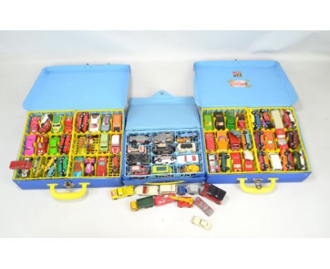
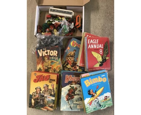
A collection of predominantly Lesney 'Matchbox Series' and Matchbox small scale diecast vehicles including Superfast and 75 Series examples with further including Corgi Juniors Whizzwheels and Husky, the majority contained in three Matchbox Superfast collectors' carrying cases, all playworn to varying extents.
Lot 120
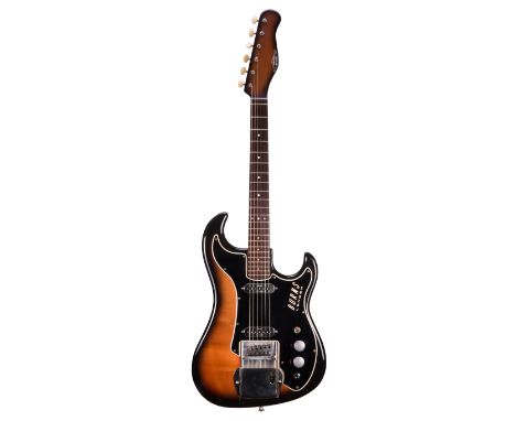
1960s Burns Short Scale Jazz guitar electric guitar, made in England, ser. no. 3738; Finish: cherry burst, faded to the front, minor blemishes and scratches but generally good for the age; Fretboard: rosewood; Frets: good; Electrics: working; Hardware: good; Case: contemporary Burns hard case; Overall condition: good
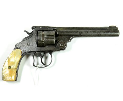
Lot 460
A Smith & Wesson First Model .44 Russian Six Shot Double Action Revolver, numbered 44945, the 15.2cm round barrel with blade foresight, the top flat marked SMITH & WESSON SPRINGFIELD MASS.U.S.A. PAT'D JAN.17 & 24.65/JULY 11 65.AUG.24.69.JULY 25.71. DEC.2.79. MAY 11 & 25.1880, the left side of the barrel stamped .44 S & W CTG, with fluted cylinder and mother of pearl grip scales, the butt strap numbered 44945, 27.5cm. Double action works. Holds at full cock. Pitting to bore. Black patching and pitting to metalwork. Right grip scale has two small cracks.
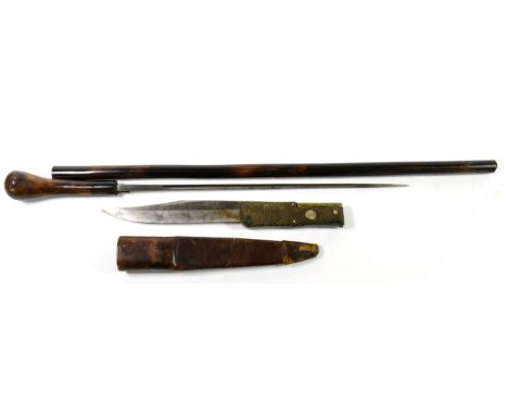
Lot 301
A 19th Century Lock Knife, the blade stamped, ''Joseph Rodgers & Sons, Cutlers to their Majesties, No.6 Norfolk Street, Sheffield, England, twin hatched horn scale grips, 26.5 cm overall, open, original leather sheath, and a Victorian Short Swordstick, fullered square section blade, length 33 cm, cane grip and locking scabbard (2). Lock knife - Blade extreme tip broken. Several small nicks to blade edge. Some wear to plated parts. Mechanism in good working order. Sheath loop broken and lacking, otherwise good. Swordstick - Blade with scattered patches of light rust, but mainly quite bright. Scabbard with small split at top. Tip of scabbard appears to be reduced slightly. Grip with small split at base. General signs of wear.
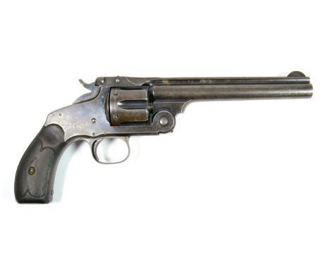
Lot 446
A Smith & Wesson Model No.3 .44 Russian Six Shot Single Action Revolver, No.25082, with blued finish, the 16.5cm round barrel with blade foresight, marked on the top flat SMITH & WESSON SPRINGFIELD MASS.U.S.A. PAT'D JAN.17 & 24.65, JULY 11 65/AUG.24.69.APR.20.75.FEB.20 & DEC.18.1877. REISSUE JULY 25.1871, the top of the backstrap stamped with an anchor, the butt strap numbered 25082, with chequered walnut grip scales, 30cm. Action works, holds at full and half cock. Some pitting to bore, but generally quite crisp. Wear to bluing. Left grip scale has two cracks, chequering on both sides is worn.
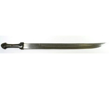
Lot 400
A Mid 19th Century Indo Persian Quadara, the 57cm single edge steel blade with three narrow fullers to the back edge and with armourer's mark, the waisted hilt with horn grip scales, lacks scabbard, 72cm. Black patching to blade. One grip scale has a small piece of horn missing above the ricasso.
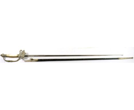
Lot 306
A Continental Court Sword by Coulaux & Cie, Klingenthal, the 76.5 cm fullered, triangular section steel blade etched with foliage and signed with maker's name, the cast and plated brass hilt and shell guard with fluted mother of pearl grip scales, the leather scabbard with plated mounts, 96cm. Blade good. Hilt and guard plating quite worn and with accumulated polish. One grip scale with broken corner. Scabbard split in two above chape. Some stitching also defective.
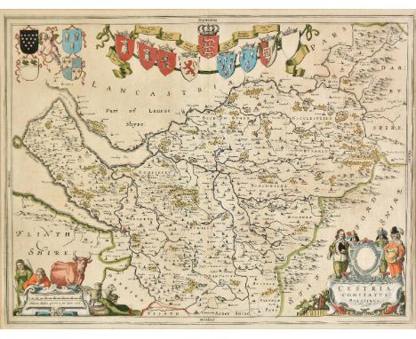
Lot 174
*Cheshire. Blaeu (Johannes), Cestria comitatus Palatinus, circa 1645, engraved map with contemporary hand colouring, decorative cartouche and mileage scale, 380 x 505 mm, mounted, framed and glazed, together with Morden (Robert), Hereford [1695 or later], hand coloured engraved map, 365 x 425 mm, framed and glazed (2)
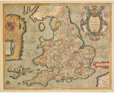
Lot 183
*England & Wales. Saxton (Christopher & Ortelius Abraham), Anglia regnum si quod aliud in toto Oceano ditissimum et florentissimum, published Jan Baptiste Vrints, Antwerp, [1603], map engraved by Pieter van den Keere, with contemporary hand colouring, large decorative cartouche and strapwork mileage scale, additional strapwork cartouche paying tribute to Christopher Saxton and a large maritime vignette commemorating the attack of the Spanish Armada to lower-left, large margins, one worm hole to lower horizontal strapwork margin, 385 x 485 mm, framed and glazed R. W. Shirley, Early Printed Maps of the British Isles 1477 - 1650 no. 258 Marcel Van den Broecke, 'Ortelius Atlas Maps' no.20. (1)
Lot 185
Essex. Chapman (John & Andre Peter), Nineteen sheets only from the large scale 'A map of the county of Essex..., ' numbers 1 - 7, 10 - 12, 14 - 16, 19 & 20, 23 & 24, [1777 or later], nineteen engraved maps with contemporary hand colouring, two duplicate sheets (nos. 5 & 12), some oxidisation to a few sheets causing cracking and flaking with occasional loss, some spotting, toning and staining, each sheet approximately 490 x 610 mm (19)
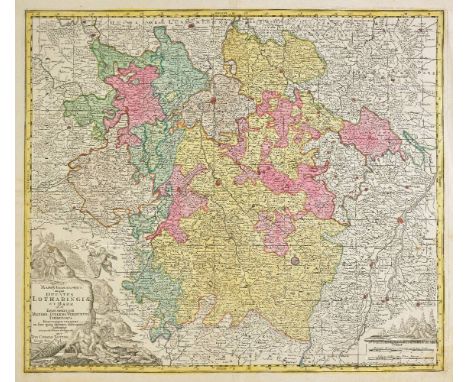
Lot 189
France & Belgium. Lotter (Tobias Conrad), Mappa geographica in qua Ducatus Lotharingiae et Barr..., Augsburg, circa 1740, engraved map with contemporary hand colouring, 500 x 585 mm, together with Nouvelle carte de Cercle de Bourgogne on l'on voit toutes les possessions de la Maison d'Autriche dans les Pays Bas..., Augsburg, circa 1740, engraved map with contemporary hand colouring, 470 x 620 mm, together with Homann (Johann Baptist and heirs of), Comitatus Flandriae in omnes ejusdem subjacentes ditoes cum adjacentibus accuratissime divisus..., Tabula Ducatus Britanniae Gallis le Gouvernemt. general de Bretagne..., Charte von Lothringen und Barr..., [and] Gubernatio generalis Languedociae occitania olim dictae..., circa 1790, together four engraved maps with contemporary hand colouring, two maps with some overall toning, each approximately 485 x 585 mm, together with Cassini de Thury (Cesar Francois), Nouveau Tableau pour servir a l'Assemblage des feuilles de la carte de France par Cassini et de celle des Pays-Bas par Ferraris, au D‚p“t G‚n‚ral de la Guerre, Paris, 1808 [or later], index sheet (with duplicate) and 123 (only?) uncoloured engraved sheets, some marginal fraying and closed tears, occasional sheets torn with loss, occasional spotting, each sheet approximately 620 x 920 mm, (some smaller sheets) The Cassini maps were the first general maps of France using a measuring apparatus were made by the Cassini family during the 18th century on a scale of 1:86,400 (one centimetre on the chart corresponds to approximately 864 meters on the ground). These maps were, for their time, a technical innovation. They were the first maps based on geodetic triangulation, and took more than fifty years to complete. Four generations of the Cassini family were involved in their production. These maps, known as "Cassini Maps" or "Maps of the Academy," are still referenced by geographers, historians and genealogists. In 1808, Napoleon I decided to produce a map intended to be more accurate than that of Cassini. However, Napoleon demanded that the primary goal of the work was to produce battlefield maps. The triangulation for this new map began also from the Paris meridian arc or French meridian line, surveyed this time by Delambre and M‚chain. Work on this map took place between 1817 and 1866. During this period several different scales were tested, with the scale 1:80,000 being chosen. This became known as the "Geological Survey" map. The funding for this work was provided by the Department of War. The first work was done by the D‚p“t de la Guerre (as referenced on the index map) and later by the Geographical Service of the Army, whose first director General Fran‡ois Perrier and his successor General Bassot re-measured the French meridian arc. The variety of paper used on this example is noticeable and indicative of a map produced over a long period of time. (131)
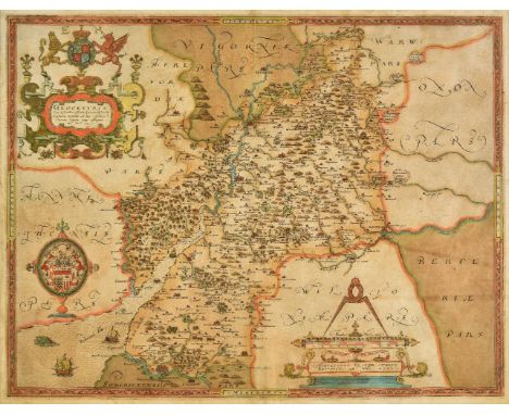
Lot 196
*Gloucestershire. Saxton (Christopher), Glocestriae sive Claudiocestriae Comit (Claudy Caesaris Nomine ad huc Celebrat) Verus Tipus atq Effigies. No. Dni. 1577, [1579], engraved map with contemporary hand colouring, elaborate strapwork cartouche, and mileage scale, 385 x 500 mm, mounted framed and glazed Engraved by Augustine Ryner and decorated with the arms of Queen Elizabeth I, a fine example in very good condition of the first ever published map of Gloucestershire. (1)
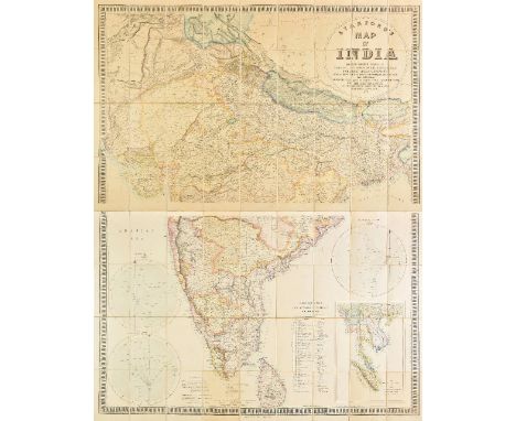
Lot 201
India. Stanford (Edward, publisher), Stanford's map of India based on the surveys executed by order of the Honourable The East India Company..., showing the Latest Territorial Acquisitions of the British Empire and the Independent and Protected States, 1857, large scale lithographic map with contemporary outline colouring, sectionalised and laid on linen on two sheets, circular cartouche, inset map of the Malay peninsula, three circular distance and bearings charts, overall size 1500 x 1230 mm, contained in a contemporary cloth slipcase with printed label to upper cover (1)
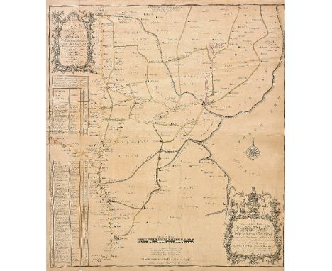
Lot 207
Lincolnshire. Bee (Stephen), A Survey and Plan of the road from the city of Lincoln. Over the Heath, thro' Dunsby Lane, Sleford, Folkingham, Bourn and Market Deeping to the city of Peterborough and also Bourn thro' Edenham, Grimsthorp Park by Swinstead and Corby to Colsterworth, sold by R. Sayer, circa 1760, large scale engraved map with sparse contemporary outline colouring, with the lettering and draughtsmanship by William Rower, dedication to 'The most noble Peregrine Bertie, Duke of Ancaster & Kesteven, Lord Great Chamberlain of England &c....', old folds, slight creasing and dust soiling, slight overall toning, occasional marginal closed tears, trimmed to neatline along right hand vertical margin, 705 x 640 mm A rare broadsheet map. No auction records found, Copac records only one copy (Oxford University). Worms & Bayton-Williams. British Map Engravers, page 572. (1)
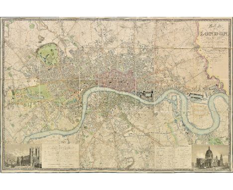
Lot 208
London. Greenwood (C. & J.), Map of London from an actual survey made in the years 1824, 1825 & 1826..., extended and comprising the various improvements to 1830, published Greenwood & Co., 2nd. edition, August 31st 1830, fine large scale map with contemporary hand colouring, engraved by Josiah Neele, sectionalised and laid on linen, calligraphic cartouche, table of explanation and reference to the parishes, inset views of Westminster Abbey and St. Pauls, dedication to King William IV, very slight staining, edged in green silk, marbled endpapers, 1250 x 1890 mm, contained in a contemporary green morocco gilt book box, all edges gilt, some wear to extremities Howgego, Printed Maps of London 1553 - 1850, 309, state 2. The Greenwood brothers Christopher and John spent three years preparing this remarkable new survey of London, prepared on the lavish scale of 8 inches to a mile, illustrating for the first time the planned development of Belgravia by Thomas Cubitt, the completion of the Grand Surrey Canal and Regent's Park one year before it was completed in 1828. This second edition has the additions of the Lea Union Canal and the names of Bayswater and East Greenwich. (1)
Lot 211
Maps. A mixed collection of approximately 350 maps, charts and town plans, 18th - 20th century, engraved and lithographic maps including foreign countries, British town plans and charts, including examples by Letts, Time Atlas, Bowen, Monin, Petermann, Mason & Payne, Philip and Bartholomew, together with a folder of large scale facsimile maps and atlases, various sizes and condition (approx.400)
-
186097 item(s)/page