We found 186097 price guide item(s) matching your search
There are 186097 lots that match your search criteria. Subscribe now to get instant access to the full price guide service.
Click here to subscribe- List
- Grid
-
186097 item(s)/page


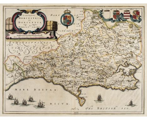
Lot 26
Dorset. Blaeu (Johannes), Comitatus Dorcestria sive Dorsettia; vulgo Anglice Dorset Shire, circa 1660, engraved map with contemporary outline colouring, large ornate cartouche, 385 x 500 mm, Spanish text on verso, together with Saxton (Christopher & Kip William). Dorcestriae comitatus vulgo Dorsett ubi olim Durotriges Insederunt, 1st edition, [1607], hand coloured engraved map, large strapwork cartouche and mileage scale, 280 x 390 mm, Latin text on verso (Qty: 2)
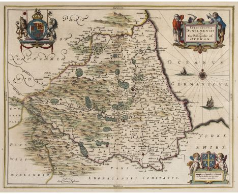
Lot 31
Durham. Jansson (Jan), Episcopatus Dunelmensis vulgo The Bishoprike of Durham, Amsterdam, circa 1650, engraved map with contemporary outline colouring, decorative cartouche, compass rose and numerous rhumb lines, slight fraying to margins but not affecting image, 410 x 510 mm, Latin text on verso, together with Blaeu (Johannes). Episcopatus Dunelmensis vulgo The Bishoprike of Durham, Amsterdam, circa 1648, engraved map with contemporary outline colouring, decorative cartouche and mileage scale, occasional printer's folds and slight creasing, central fold repaired, 385 x 505 mm, Dutch text on verso, with Slater (Isaac & Pigot James). Durham, circa 1855, engraved map with contemporary outline colouring, uncoloured vignette of Durham Cathedral, 235 x 365 mm (Qty: 3)
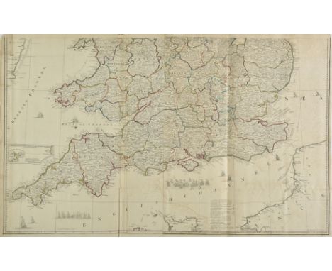
Lot 36
England & Wales. Rocque (John), England and Wales drawn from the most accurate surveys, Containing all the Cities, Boroughs, Market Towns and Villages..., 1794, large engraved map with contemporary outline colouring on two sheets, large uncoloured cartouche, inset map of the Scilly Isles, some offsetting, overall size 1200 x 985 mm, together with Kitchin (Thomas). Karte von England und Wales..., published F. A. Schraembl, Vienna, 1787, large engraved map with contemporary outline colouring on four sheets, large uncoloured cartouche, stained along central folds, each sheet approximately 660 x 550 mm, with Walch (Johannes). Charte von England und Wallis, Augsburg, 1803, large engraved map after Thomas Kitchin with contemporary outline colouring, on two sheets, inset map of the Scilly Isles, large oval cartouche, each sheet approximately 640 x 1080 mm, plus Pinkerton (John). England Northern part [and] England Southern part, published Cadell & Davies, Longman, Hurst-Rees, Orme & Brown, 1811, engraved map with contemporary outline colouring on two sheets, some dust and finger soiling, the 'Southern part' with an ink mileage scale in the lower margin added by a juvenile hand, each sheet approximately 515 x 720 mm, with another copy of the 'Northern part' (Qty: 11)
Lot 38
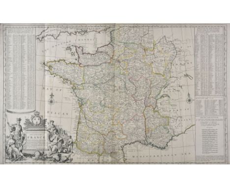
France. Moll (H), A New and Exact Map of France divided into all its Provinces and Acquisitions according to the newest observations..., D. Midwinter, P. Overton and T. Bowles, circa 1710, engraved map with contemporary outline colouring, large uncoloured allegorical cartouche, lower margin frayed and trimmed,old folds, laid on later stiff paper, 610 x 975 mm, together with DelaRochette (Louis). Map of the Empire of Germany including all the states comprehended under that name: with the Kingdom of Prussia &c. Robt. Sayer, circa 1794, large scale map with contemporary outline colouring, engraved by T. Kitchin on two sheets, old folds, each sheet approximately 520 x 1200 mm (Qty: 2)
Lot 47
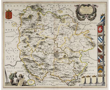
Herefordshire. Blaeu (Johannes), Herefordia Comitatus Hereford-Shire, circa 1650, engraved map with contemporary outline colouring, several repaired marginal closed tears but not affecting image, central fold repaired on verso, 410 x 505 mm, Latin text on verso, together with Saxton (Christopher & Hole W.). Frugiferi AC Ameni Herefordiae Comitatus qui olim pars suit Silurum delineatio, [1637], hand coloured engraved map, slight creasing, 295 x 310 mm, with Speed (John). Worcestershire described, Thomas Bassett & Richard Chiswell, [1676], hand coloured engraved map, inset town plan of Worcester, large strapwork cartouche and mileage scale, central fold strengthened and repaired on verso, slight mount staining and marginal spotting, 385 x 510 mm, English text on verso (Qty: 3)
Lot 61
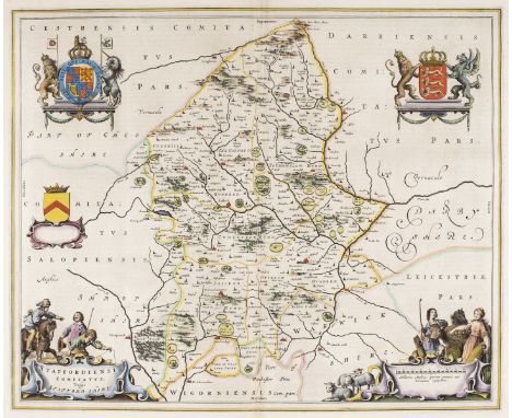
Midland counties. Blaeu (Johannes), Staffordiensis comitatus vulgo Stafford Shire, Amsterdam, circa 1660, hand coloured engraved map, decorative allegorical cartouche and mileage scale, 415 x 505 mm, Spanish text on verso, together with Rutlandia comitatus Rutland Shire, Amsterdam, circa 1645, engraved map with bright contemporary hand colouring, large decorative cartouche and mileage scale, 385 x 505 mm, Dutch text on verso, with Jansson (Jan). Comitatus Cantabrigiensis vernacule Cambridgeshire, Amsterdam, circa 1660, engraved map with contemporary hand colouring, ornate cartouche, and mileage scale, decorated with the twenty-four heraldic shields of noblemen and Cambridge colleges, slight overall toning, margins frayed and chipped, some closed tears affecting image, professionally repaired on verso, the whole backed with archival tissue, trimmed to neatline and margins extended, 420 x 510 mm, no text on verso (Qty: 3)
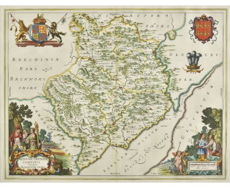
Lot 62
* Monmouthshire. Blaeu (Johannes), Monumethensis comitatus vernacule Monmouth Shire, Amsterdam, circa 1645, engraved map with bright contemporary hand colouring, large decorative cartouche and mileage scale, 380 x 500 mm, mounted, framed and double glazed, French text on verso, together with Bowen (Emanuel). An Accurate Map of the County of Monmouth Divided into Hundreds..., printed for T. Kitchin, R. Sayer, J. Ryall, Carington Bowles, H. Overton, J. Bowles and H. Parker, [1762], engraved map with contemporary outline colouring and some later enhancement, some creasing, 505 x 415 mm, mounted, framed and glazed (Qty: 2)
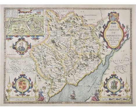
Lot 63
Monmouthshire. Speed (John), The Countye of Monmouth wih the sittuation of the Shire-towne described, John Sudbury & George Huimble, [circa 1627], hand coloured engraved map, inset town plan of Monmouth, large strapwork cartouche and mileage scale, one printer's fold, 385 x 510 mm, English text on verso (Qty: 1)
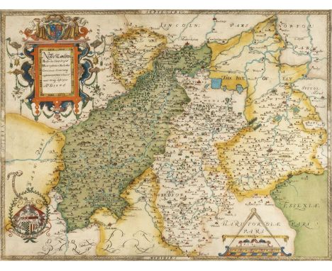
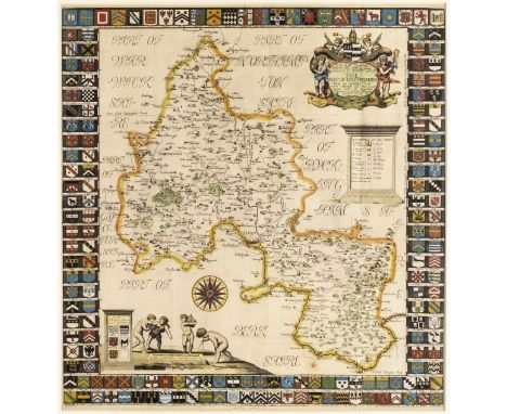
Lot 66
* Northamptonshire & Surrounding Counties. Saxton (Christopher), Northamton, Bedfordiae, Cantabrigiae, Huntingdoniae et Rutlandiae, Comitatuum Vicinarumq. Regionum partium adiacent nova veraq. Descriptio. A. D. 1576, [1579], engraved map with contemporary hand colouring, strapwork title cartouche surmounted by the royal arms to upper left, arms of Thomas Seckford lower left, mileage scale surmounted by dividers, one small printer's fold, 405 x 525 mm, mounted, framed and glazed (Qty: 1)NOTESThe first printed map of Northamptonshire, Bedfordshire, Cambridgeshire, Huntingdon and Rutland.
![* Northamptonshire. Smith (William), Northamptoniae Comitatus Descriptio....., J.Overton [1675 or later], engraved map with c](https://cdn.globalauctionplatform.com/0450faa8-8d79-4719-b091-abb300cb473d/0e2ddf88-9169-4a73-bc82-abb400fad2cd/468x382.jpg)
Lot 67
* Northamptonshire. Smith (William), Northamptoniae Comitatus Descriptio....., J.Overton [1675 or later], engraved map with contemporary outline colouring, elaborate strapwork cartouche and mileage scale, 365 x 480 mm, mounted, framed and glazed (Qty: 1)NOTESWilliam Smith was an antiquary who was a contemporary of Christopher Saxton. He only completed twelve maps which were probably intended for an uncompleted English atlas. The maps were individually first published in 1602, and the plates were acquired by John Overton in 1670. Until comparatively recently their authorship was doubtful and they were known as the 'Anonymous Maps'. All of William Smith's maps are considered scarce.
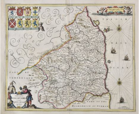
Lot 68
Northumberland. Jansson (Jan), Comitatus Northumbria vernacule Northumberland, circa 1648, engraved map with contemporary outline colouring, decorative cartouche and mileage scale, compass rose and numerous rhumb lines, central fold partially strengthened on verso and with a short split, 410 x 500 mm, Latin text on verso, together with Blaeu (Johannes). Insula Sacra vulgo Holy Island et Farne, Amsterdam, circa 1645, engraved map with contemporary outline colouring, very slight staining to margins, 390 x 475 mm, French text on verso (Qty: 2)
Lot 78
* Oxfordshire. Plot (Robert), The Map of Oxfordshire, circa 1677, hand coloured engraved map, decorative cartouche, mileage scale, table of explanation and compass rose, old folds, slight creasing, 500 x 480 mm, mounted, framed and glazed (Qty: 1)NOTESCreated by the first keeper of the Ashmolean Museum of Oxford and decorated with 172 coats of arms of the county's gentry, Oxford colleges, the city and the four county towns. One of the most decorative maps of Oxfordshire ever produced.
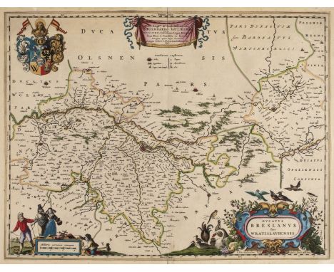
Lot 83
Poland. Blaeu (Johannes), Ducatus Breslanus sive Wratislaviensis, Amsterdam, circa 1663, engraved map with contemporary hand colouring, large decorative cartouche and mileage scale, four professionally repaired marginal closed tears, 425 x 550 mm, no text on verso, together with Ducatus Silesiae Ligniciensis Auctore Iona Scultero Sprotta Silesio, Amsterdam, circa 1663, engraved map with contemporary hand colouring highlighted in gilt, some offsetting and staining, 420 x 530 mm, French text on verso, with Ducatus Silesiae Wolanus..., Amsterdam, circa 1663, engraved map with contemporary outline colouring, some offsetting and staining, central fold partially split, oxidisation to old watercolour causing some cracking and splitting, 425 x 535 mm, French text on verso, plus, Ducatus Silesiae Grotganus cum Districtu Episcopali Nissensi, Amsterdam, circa 1663, engraved map with contemporary outline colouring, central fold partially split, some offsetting and staining, 395 x 525 mm, French text on verso, (Qty: 4)
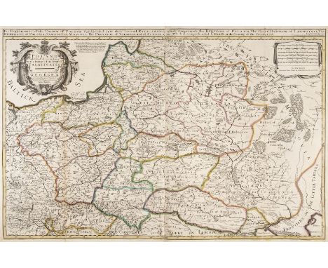
Lot 84
Poland. Bowles (John), Poland Subdivided according to the extent of its Severall Palatinates, circa 1744, engraved map with contemporary outline colouring, large uncoloured cartouche, additional title above map, old folds, short splits to old folds, folds strengthened on verso, 570 x 860 mm (Qty: 1)NOTESRare unrecorded state of William Berry's two sheet map of Poland originally published in about 1683 in London. William Berry's map of Poland was the first large scale map of Poland to be published in England and whilst the map credits Nicholas Sanson's earlier map as its source the map is actually drawn from Hubert Jaillot's map of Poland published about ten years earlier in Amsterdam. The first edition has a dedication to Charles II whereas this edition acknowledges the present king, George II. The scarce second state bears the publishing imprint of Thomas Taylor, Philip Overton and John Lenthall. We have been unable to locate another example of this map and this example was catalogued by Ashley Baynton Williams for the London Antiquarian Book Fair of 2013.
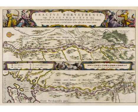
Lot 107
River Dnieper. Blaeu (J.), Tractus Borysthenis vulgo Dniepr et Niept dicti a Civitate Czyrkassii as ostia Ilmien lacum per quem in Pontum Euxinium se exonerat..., [in set with] ...., à Kiovia usque ad Bouzin..., [and] à Bouzin usque ad Chortyca Ostrow..., [and] ..., à Chortika Ostro ad Urbem Oczakow ubi in Pontum Euxinum se exonerat, Amsterdam, [1662 - 1665], set of four engraved maps with bright contemporary outline colouring showing the course of the River Dnieper, each with an elaborate and decorative cartouche and mileage scale, each approximately 390 x 540 mm, Latin text on verso (Qty: 4)NOTESPublished in the 'Atlas Maior'.
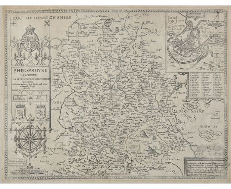
Lot 115
Shropshire. Speed (John), Shropshyre described, The Sittuation of Shrowesbury Shewed with the Armes of thos Earles and other memorable things observed, Dicey & Co, circa 1770, uncoloured engraved map, large strapwork cartouche and mileage scale, inset town view of Shrewsbury, slight mount staining, laid on linen, 385 x 505 mm (Qty: 1)
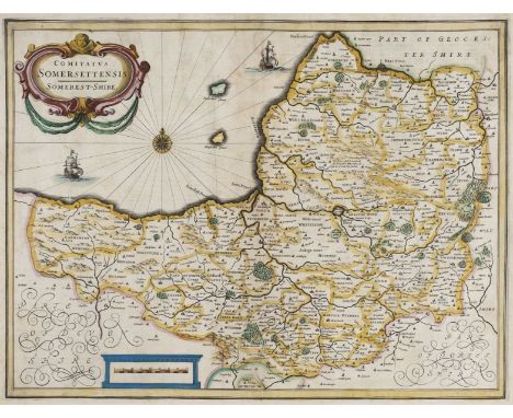
Lot 116
Somerset. Jansson (Jan), Comitatus Somerettensis Somerset-Shire, circa 1638, engraved map with contemporary hand colouring, ornate strapwork cartouche and mileage scale, compass rose and numerous rhumb lines, slight staining, 385 x 510 mm, Dutch text on verso, together with Collinson (John). A Map of the County of Somerset, published C. Dilly, 1792, hand coloured engraved map originally published in Collinson's ' The History and Antiquities of the county of Somerset, collected from authentick records..., ', old folds, some weakness where old folds cross, one area of crude repair on verso, 480 x 630 mm, with Morden (Robert). Somersetshire, [1695], engraved map with contemporary outline colouring (it is rare to find Morden's maps with contemporary colouring), 360 x 425 mm, plus Slater J & Pigot (James). Somersetshire, circa 1857, engraved map with contemporary outline colouring, uncoloured vignette of Wells Cathedral, 240 x 360 mm (Qty: 4)NOTESThe first described item is in the scarce 'pre-atlas' state printed before the addition of the six coats of arms and a re-working of the title cartouche.
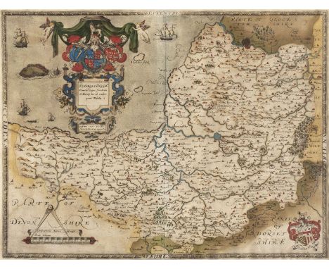
Lot 117
* Somerset. Saxton (Christopher), Somersetensem Comitat (agri fertiltate celebrem) hec ob oculos ponit Tabula. Anno 1575. et D. Elizabethe Regine Ao 17, [1579], engraved map with contemporary hand colouring, ornate heraldic and strapwork cartouche and mileage scale, with the arms of Thomas Seckford in the lower right corner, 395 x 520 mm, mounted framed and glazed (Qty: 1)NOTESThe first county map of Somerset.
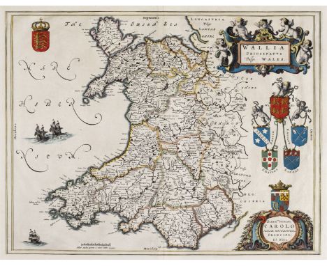
Lot 125
Wales. Blaeu (Johannes), Wallia Principatus vulgo Wales, Amsterdam, circa 1660, hand coloured engraved map, large decorative cartouche, 390 x 495 mm, no text on verso, together with Jansson (Jan). Principatus Walliae pars Australis vulgo South-Wales, Amsterdam, circa 1650, engraved map with contemporary outline colouring, large decorative cartouche and mileage scale, compass rose and numerous rhumb lines, repaired closed tears affecting image, slight marginal fraying, 415 x 525 mm, French text on verso, with Bertius (Petrus). Cambria, [1616- 1639], uncoloured miniature engraved map, with additional title in French above map, and French text to verso, 100 x 140 mm (Qty: 3)
Lot 129
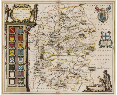
Wiltshire. Blaeu (Johannes), Wiltonia sive comitatus Wiltoniensis Anglis Wil Shire, circa 1660, engraved map with contemporary outline colouring, decorative cartouche and mileage scale, slight worming, 415 x 500 mm, Spanish text printed on a separate sheet and tipped on to verso, together with Walker (J & C). Wiltshire. Places of the Meeting of Foxhounds, published in 'Hobson's Fox Hunting Atlas', circa 1850, lithographic map with contemporary outline colouring, slight soiling, 405 x 330 mm (Qty: 2)


Lot 10
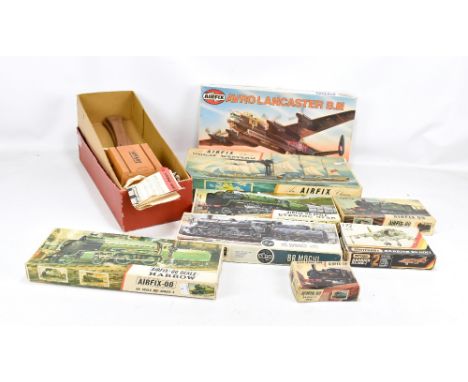
Three Trackside Days Gone diecast models, AEC Mammoth with flatbed trailer vand brick load, DG 149000, Scammell Ballast low loader & Harvard load DG 110005 and Guy Pantechnicon DG 146006, also Days Gone Showmans Scammell six wheeler, Biddall's Fun Fair DG 044034, two Gaugemaster 1:87 scale model cars, Maisto Corvette ZR1 and open top double decker London Bus, all mint in boxes (storage wear to Corvette and Bus boxes)
Lot 174
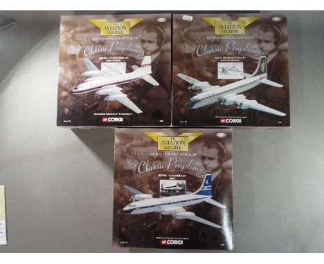
Corgi - Three limited edition 1:144 scale diecast model aeroplanes from the Corgi Aviation Archive Classic Propliners collection comprising # 48605 Bristol Britannia 314 G-ATNZ Caledonian Airways, # 48601 Bristol 175 Britannia 102 Laker Airways and # 48602 Bristol 175 Britannia 312 BOAC. Models appear M in original boxes (# 48601 appears to be lacking landing gear pieces). [3]
Lot 177
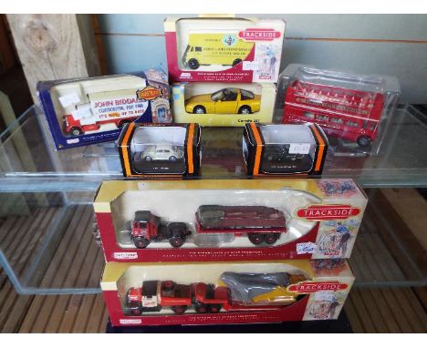
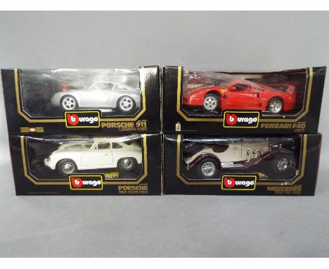
Bburago - Four boxed Bburago 1;18 scale diecast model cars. Lot consists of #3009 Mercedes Benz SSK 1928; #3032 Ferrari F40 1987; #3050 Porsche 911 Carrera 1993; #3021 Porsche 356B Coupe 1962. Models appear to be in Mint condition in Good boxes with some imperfections as loose cellophane windows. (4)
Lot 180
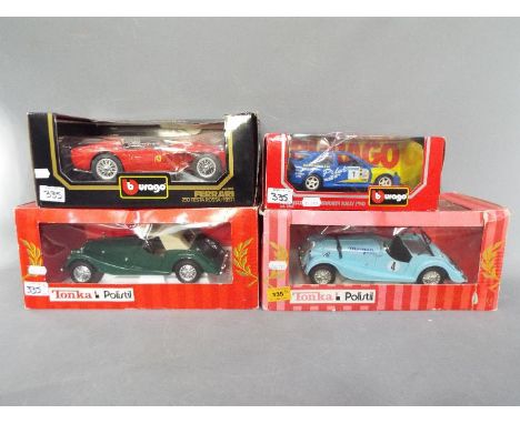
Bburago, Polistil - Four boxed Bburago and Polistil 1:18 and 1:24 scale diecast model cars. Lot consists of Polistil #01868 Morgan Plus 8; Polistil #01690 Morgan Berlinetta; Bburago #0543 Ford Escort RS Cosworth Rally 1994; #3007 Ferrari 250 Testarossa 1957. Models appear to be in Mint condition in Good boxes with some imperfections such as loose and cracked cellophane windows. (4)
-
186097 item(s)/page