We found 185385 price guide item(s) matching your search
There are 185385 lots that match your search criteria. Subscribe now to get instant access to the full price guide service.
Click here to subscribe- List
- Grid
-
185385 item(s)/page


Lot 11
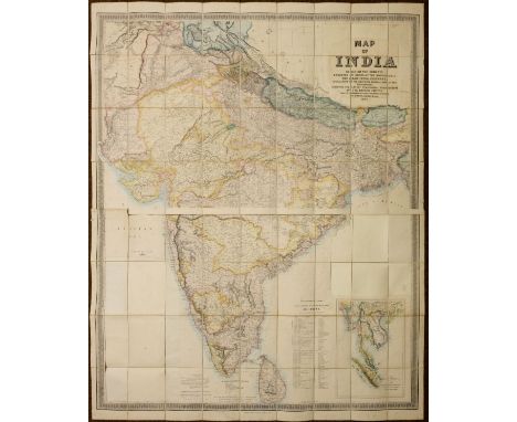
Stanford (Edward, publisher). Map of India, based on the surveys executed by order of the honorable The East India Company, special maps of the surveyor general and other authorities; showing the latest territorial acquisitions of the British Empire and the independent and protected states, railways, canals, &c., 1857, large-scale lithographic map on two sheets, with contemporary outline colouring, inset map of the Malay Peninsula, sectionalised on linen, the title cartouche to upper right excised, and laid back down on later backing paper, with loss of the circular decorative border and similar excision of the three circular distance and bearings charts to lower left and to centre right, overall size 1500 x 1230 mm, contained in contemporary cloth slipcase with printed label to upper cover, rubbed and minor fraying to extremities, some water staining to upper cover (Qty: 1)NOTESSold as seen, not subject to return.
Lot 111
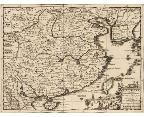
East Indies. Van der Aa ( Pieter ), Les Indes Orientales suivant les Nouvelles Observations..., circa 1720, uncoloured engraved map,decorative cartouche and mileage scale, wide margins, 285 x 340 m (Qty: 1)NOTESDetailed map of South East Asia, Japan, Korea, India and the tip of Australia in the lower right. The map is centered on the Ganges and extends from Japan, the Philippines and the Moluccan Islands to the Persian Gulf and Indian Ocean.
Lot 123
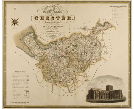
Greenwood (C. & J.). A collection of eleven county maps, circa 1830, engraved maps, eight with contemporary hand colouring, some toning and staining, one map trimmed to neatline and crudely re-margined with later paper, some marginal chipping and tears with occasional loss, one laid on hardboard, occasional duplicates, each approximately 585 x 700 mm, together with Hodgson (Thomas). Plan of the County of Westmorland, Describing minutely the Boundaries of Wards, Parishes, and Townships ... Turnpike, Carriage, Bridle and Roman Roads, also the Positions of Towns, Villages, Seats & Farm Houses, Commons, Parks, Woods, Lakes, Mountains, &c. &c. 1828, uncoloured engraved large scale map, vignettes of Appleby and Lowther castles, calligraphic title, table of explanation, list of the heights of mountains and the depths of Lakes, compass rose and mileage scale, the map is cut into four parts, each laid on card and then the whole on to hardboard, the board is bowed, printed surface creased, dust soiled and frayed with areas of loss to the margins and upper left and right corners, 1390 x 1600 mm (Qty: 12)NOTESThe Greenwood maps comprise of :- Cheshire, Nottinghamshire, Warwickshire, Cumberland, Staffordshire, Westmorland, North East Circuit of Wales, The North West Circuit of Wales, Monmouthshire and Worcestershire (2 copies).
Lot 140
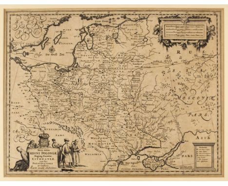
* Poland. Allard (Hugo), Nova Totius Regni Poloniae, Magniq. Ducatus Lithuaniae, cum suis Palatinatibus ac Confinis, published Amsterdam by Guillaume Le Vasseur de Beauplan, circa 1660, uncoloured engraved map, decorative cartouche and mileage scale, slight overall toning 390 x 510 mm, mounted, framed and glazed (Qty: 1)
Lot 143
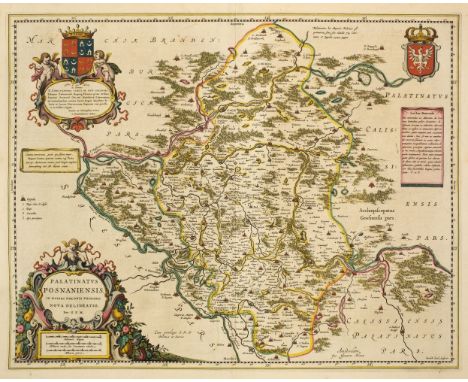
Poland. Blaeu (Johannes), Palatinatus Posnaniensis, in Maiori Polonia Primarii nova delineatio. per G. F. M. Amsterdam, circa 1670, engraved map with contemporary hand colouring, large floriate cartouche and mileage scale, 420 x 530 mm, Spanish text on verso, together with Ducatus Silesiae Giogani vera delineatio, Amsterdam circa 1640, engraved map with contemporary outline colouring, decorative strapwork cartouche and table of explanation, 425 x 510 mm, Latin text on verso (Qty: 2)
Lot 146
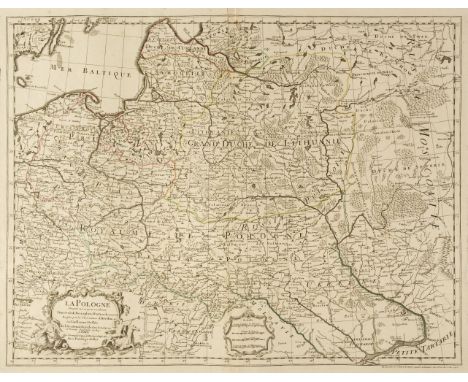
Poland. De L'Isle (Guillaume), La Pologne Dressée sur ce qu'en ont donné Starovolsk, Beauplan, Hartnoch et autres..., Paris, 1703, engraved map with contemporary outline colouring, uncoloured decorative cartouche and mileage scale, 490 x 635 mm, together with another example with later outline colouring and several areas of damage, crudely repaired (Qty: 2)
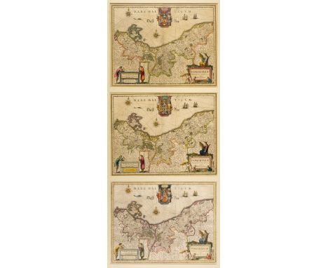
Lot 159
Poland/Pomerania. Jansson (Jan), Nova Illustrissimi ducta Pomeraniae tabula, Amsterdam, circa 1630, engraved map with contemporary outline colouring, large decorative cartouche and mileage scale, compass rose and numerous rhumb lies, occasional marginal repaired closed tears but not affecting image, 385 x 495 mm, French text on verso, together with Dankerts (Theodore). Ductas Pomeraniae Tabula Generalis in qua sunt Ducatus Pomeraniae, Stettinensi, Cassubiae, Vandaliae et Bardensis..., Amsterdam, circa 1690, engraved map with contemporary outline colouring, large decorative cartouche, some marginal finger and dust soiling, 500 x 580 mm, with De Wit (Frederick). Marchionatus Brandenburgi et Ducatus Pomeraniae tabula..., Amsterdam, circa 1680, engraved map with contemporary outline colouring, very slight staining, 490 x 565 mm, plus Rossi (Giacomo Giovanni), La Pomerania divisa in Citerioe ò Reale..., Rome 1689, hand coloured engraved map, large decorative cartouche, 435 x 555 mm (Qty: 4)
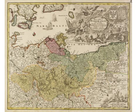
Lot 161
Poland/Pomerania. Seutter (Matthaus), Ducatus Pomeraniae cum magna Maris Balthici et Provinciarum ad Nexarum Parte..., Augsburg, 1725 - 1740, engraved map with contemporary hand colouring, very large uncoloured baroque allegorical cartouche, manuscript page number to upper right corner, 500 x 570 mm, together with Schenk (Petrus). Ducatus Pomeraniae Tabula Generalis in qua sunt Ducatus Pomeraniae, Stettinensi Cassubiae Vandalie et Bardensis..., Amsterdam, circa 1710, engraved map with contemporary hand colouring, large uncoloured cartouche, some oxidisation to old colour causing splitting and cracking to image with small areas of loss, 490 x 580 mm, with Brüggemann (Ludwig Wilhelm & Gadebusch Thomas). Special Charte vom Herzogthum Pommern nebst den angränzenden Ländern von Meclenburg der Ucker ung Neumark Westpreussen un Netzdistrict..., Nuremberg, 1702, engraved map with contemporary hand colouring, large table of explanation, title repeated in French above map, 465 x 710 mm, plus Dezauche (Jean Claude). Le Duche de Pomeranie compris sous le Cercle de la Haute Saxe divise suivant qu'il est presentement partagé entre la Couronne de Suede et L'Eslecteur de Brandebourg..., Paris, circa 1780, engraved map with contemporary outline colouring, large uncoloured cartouche and mileage scale, 465 x 655 mm, and Sotzmann (Daniel Friedrich). Der Nördliche Theil des Ober Saechsischen Kreises oder die Mark Branenburg und das Herzogthum Pommern..., Berlin [1793], engraved map with contemporary outline colouring, originally published in 'Repertorium zur Karte von Deutschland...,' 255 x 295 mm (Qty: 5)
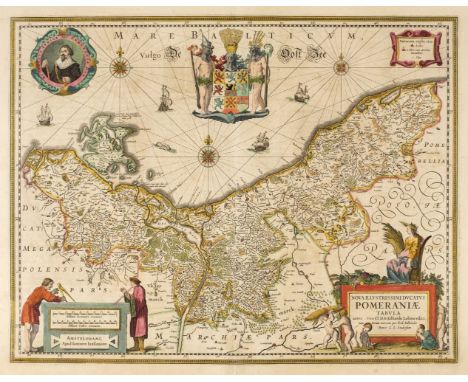
Lot 162
* Pomerania . Blaeu (Willem Janszoon), Pomeraniae ducatus tabula Auctore Eilhardo Lubino , Amsterdam, circa 1640, engraved map after E. Lubin, with contemporary outline colouring, decorative cartouche and mileage scale, compass rose and numerous rhumb lines, with two additional copies but different editions of the same map, each 380 x 490 mm, triple aperture mount, framed and glazed (Qty: 1)NOTESA highly decorative map of the area of Pomerania, in what is now present day eastern Germany and Poland . The map is dominated by the elaborate coat of arms of Pomerania. The mileage scale is supported by two figures of scholars or possibly cartographers, one wielding a pair of dividers.
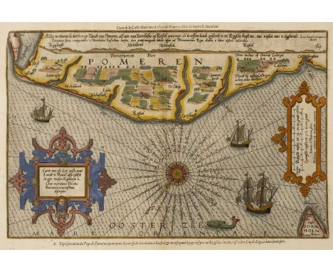
Lot 164
Pomerania . Waghenaer (L. J.), Caerte van de Zee Custe vant Landt te Pomere , also Tselfde in zijn Wessen en Gedaente is, Antwerp, circa 1600, sea chart engraved by J Van Doetecum, contemporary hand colouring with later enhancement, large strapwork cartouche and mileage scale, compass rose and numerous rhumb lines, two repaired worm holes in margin but not affecting image, 340 x 505 mm, French text on verso (Qty: 1)NOTESA Waghenaer sea chart taken from the French edition of the Mariner's Mirror. 'Le Nouveau mirroir des Voyages et Navigations'. Koeman Wag 11a
Lot 166
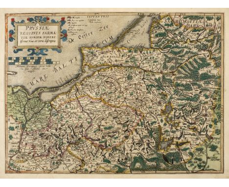
Prussia. De Jode (Gerard), Prussiae Regionis Sarmatiae Europae Nobibilis simae nova et vera descriptio , Antwerp, circa 1593, uncoloured engraved map with contemporary outline colouring, large strapwork cartouche and mileage scale, 365 x 495 mm, Latin text on verso (Qty: 1)NOTESA scarce early map of Prussia printed in Antwerp by Gerard de Jode's son, Cornelis. De Jode maps are scarce because the publication of his atlas was deliberately hampered by his cartographic rival Abraham Ortelius who quite rightly perceived De Jode as a serious threat to his dominance of 16th century atlas and map publishing. Ortelius was very well connected and used his influence to block the publication of De Jode's 'Speculum Orbis Terrae' for over five years. De Jode's maps are visually stunning but continued interference by Ortelius resulted in commercial failure and they are rarely available today because so few copies of the atlas were ever sold.
Lot 182
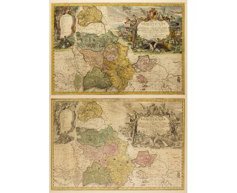
* Silesia. Homann (Johann Baptist heirs of), Principatus Silesiae Glogoviensis novissima Tabula geographica..., Nuremberg, 1739, engraved map with contemporary outline colouring and some later enhancement to the cartouche, key plate and mileage scale, very large decorative cartouche, slight creasing and dust soiling, mounted with another copy of the same map but with an uncoloured cartouche and key plate, 555 x 810 mm, framed and glazed (Qty: 1)NOTESA large and detailed map of the principality of Grunberg - part of Silesia - and published in the 'Atlas Silesiae Id Est Ducatus Silesiae generaliter Quatuor Mappis nec non Specialiter...,'. The atlas had four general maps and sixteen large scale detailed maps of Poland and Silesia, all with extraordinary and highly decorative cartouches.
Lot 184
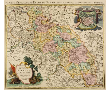
Silesia/Poland. Covens J. & Mortier P. (publishers), Sup.s et Inferioris Ducatus Silesiae in suos XVII Minores..., Amsterdam, 1741, engraved map with contemporary outline colouring, inset town plan of Breslau, large decorative cartouche, title repeated above map in French, 505 x 580 mm, together with Jansson (Jan). Silesiae Ducatus Accurata et vera delineatio..., Amsterdam, circa 1660, engraved map with contemporary hand colouring, but somewhat faded, some staining, 390 x 495 mm, Latin text on verso, with Schenk (P.). Mappa Geographica Exactissima Cointinens Imperatoris Haereditarium DominiumSilesiam nec non eiusdem Provincias interiores Comitatus..., Amsterdam, circa 1705, engraved map with contemporary outline colouring, some staining, 495 x 580 mm, with Blaeu (Johannes). Baronatus Carolato Bethaniensis in Silesia Inferiore..., Amsterdam, [1662], uncoloured engraved map, 415 x 510 mm, Spanish text on verso, plus Schenk (Peter). Ducatus Silesiae Wolanus, Amsterdam, circa 1690, engraved map with contemporary outline colouring, strapwork cartouche and mileage scale, short split at base of central fold, 410 x 385 mm and Walch (Johannes). Charte von Schlesien Maehren und der Lausitz..., Augsburg, 1805, engraved map of the whole of Silesia with contemporary outline colouring, later manuscript title to verso, 500 x 560 mm (Qty: 6) NOTE: Schenk (Peter). Ducatus Silesiae Wolanus, Amsterdam, circa 1690, this is in fact an anonymous copy of the Hondius map (with orientationchanged from East to North), ordered by Pitt for the English Atlas andhas the Atlas number XXVII in the upper right hand corner

Lot 186
Silesia/Poland. Sanapius (Daniel), Ducatus in Silesia Inferiore Olsnensis Novissima Delineatio Wratislaviae..., circa 1729, uncoloured engraved map with and inset prospect of Olésnica and an allegorical vignette, strapwork cartouche and dedication, old folds strengthened on verso, 415 x 575 mm, together with Danckerts (Theodore), Accuratissima Ducatus Silesiae Regnum Bohemiae, Marchionatus Moraviae et Lusatiae..., Amsterdam, circa 1700, engraved map with contemporary outline colouring, decorative cartouche and mileage scale, slight marginal staining, central fold strengthened on verso, 500 x 580 mm, with Schenk (Peter). Le Royaume de Boheme Duché de Silesie, Les Marquisat de Moravie et de Lusace, Amsterdam, circa 1700, engraved map with contemporary hand colouring, title repeated above map in French, some oxidisation to old colour causing cracking and flaking and slight loss, crudely repaired on verso, slight staining, 485 x 585 mm, plus an unattributed and untitled coloured 18th century map of Upper Silesia, possibly part of a large wall map of Silesia, old folds, occasional wormholes repaired on verso, slight soiling, 440 x 340 mm (Qty: 4)Note: The Sinapius ‘Ducatus in Silesia… is state 2 (of 2) from 1720 not1729, and the unattributed map of Upper Silesia is from T.C. Lotter’s4-sheet wall map ‘La Haute et la Basse Silesie’
Lot 867
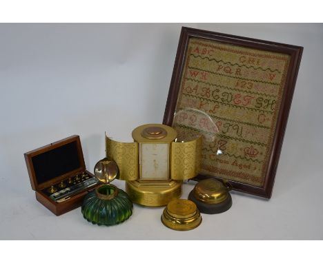
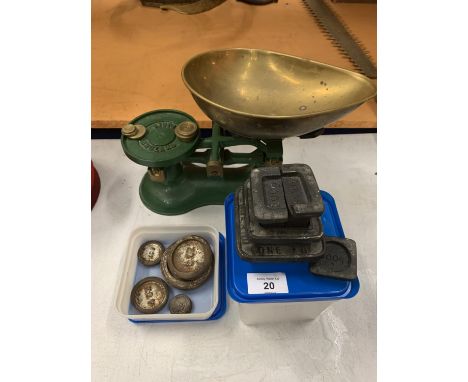
A 1950s design gilt-brass ImHof novelty clock/cigarette dispenser with musical automaton doors, 16 cm high to/w a German Art Nouveau green lustre glass inkwell of ribbed mushroom form with organic copper hinged cover, two camping spirit stoves, a boxed set of scale-weights and an early 19th century alphabet sampler by Margaret Cross, aged 9 (6)

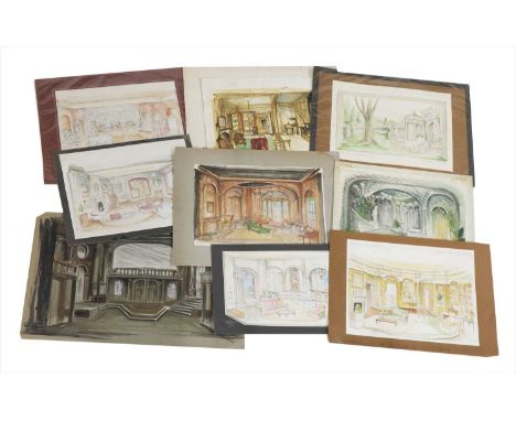
Lot 95
John Page An archive of twenty-seven set designs from various stage productions, Watercolour and pencil, to include: 'A Friend Indeed', 'The Kingfisher', 'Little Women', 'We're Strangers Here...', 'Venus Observed', 'Diary of a Scoundrel' largest approximately 54 x 65cm, and various scale plans (qty.)

Lot 556
Rare Aquastar Deepstar 10 ATM gent's stainless steel wristwatch, circa 1960's, numbered to reverse 229499, having subsidiary calendar dial, rotating bezel with Deepstar scale for calculation of aggregate diving times and the Tropic rubber strap (scratched and worn) Condition Reportsee images. Badly scratched, gouged, scuffed, banged all over. Unable to get the back off. we do not guarantee it working and it doesn not. and the stop start buttons do not work

Lot 317
Handmade Bergama Rosey Oriental Hand-Spun Wool Savonnerie Carpet 8 x 10 - Light Blue/Ivory The Most Luxurious Deep Piled Rug Available Incredibly Heavy Dense Pile And Superb Furnishing Colours Combine To Give These Rugs A Stately Feel- No Surprise There As They Were Originally Made For The French Courts However They Are Highly Ornate In The French Floral Style The Chinese Weavers Started To Make Superb Reproductions Of The Original French Savonnerie In The Late 20thcentury They Are Faithful To The Originals To The Exact Designs And Colours And Are Excellent Value For Money Considering The Weight Of Wool Used Once In A Room They Do Not Move And Provide Unrivalled Luxury Underfoot As Well As Super Sound And Heat Insulation They Are A Rug Made To Fit Into A Traditional Home Often In A Room Filling Size When The Scale Allows The Designs To Come To The Fore As A Long-Term Floor Covering A Savonnerie Should Last At Least 100 Years 8 x 10 - Light Blue/Ivory

-
185385 item(s)/page