

Blaeu, Willem 1662 Nova Belgica et Anglia Nova This important map, first issued in 1635, is one of the first to focus on the Dutch colony in North America and to name "Nieu Amsterdam" (New York). It is based on the manuscript of Andriaen Block (1614), a Dutch fur trader, who explored the area between Cape Cod and Manhattan and was the first to correctly delineate the longitudinal scale of the coastline and establish Manhattan as an island. The colony of "Nieu Pleimonth" is identified, as well as other English names along the coast, which were derived from Smith`s map of New England in 1616. The map is oriented with north to the right and is richly adorned with a variety of wildlife, including the first appearance of beavers, polecats and otters on a printed map. Quebec is noted with a minute depiction of the fort and buildings, and the mythical kingdom pf "Norumbega" is noted near the" R. Pentagouet " (Penobscot River) in present-day Maine. A large Mohawk village is shown derived from the White-de Bry engravings. It is further embellished with a large title cartouche flanked by two natives, sailing ships, canoes, and compass roses. Latin text on verso. 19.7" W x 15.2" H A fine impression with wide, original margins, light show-through of text on verso, and a number of tiny worm holes along centerfold that have been professionally infilled with a small amount of image in facsimile. There are some small chips and tears in blank margins that have also been professionally repaired.
We found 186094 price guide item(s) matching your search
There are 186094 lots that match your search criteria. Subscribe now to get instant access to the full price guide service.
Click here to subscribe- List
- Grid
-
186094 item(s)/page

Anon., 1779 A Chart of Delaware Bay and River, from the Original by Mr. Fisher of Philadelphia - 1776 This "Revolutionary War" map was based on the chart Joshua Fisher made of Delaware Bay in 1756 and expanded upon in 1776. The Fisher map was the most important map of the bay and river in the eighteenth century. This map was derived from the 1776 edition, and was published with an article updating the British public on the war in the colonies. It shows the bay and beyond to Philadelphia and is filled with place names and the location of many hazards to navigation along the waterway. Locates Cape May, Turtle Gut Inlet, Cape James, Egg Island, Salem, and much more. Two distance scales and the direction rose with fleur-de-lis orients north to the right. Published in the July, 1779 issue of the Gentleman`s Magazine. 9.2" W x 7.2" H Issued folding with one faint spot below distance scale.

Bellin, Jacques Nicolas 1757 Carte de la Caroline et Georgie. Pour Servir a l`Histoire Generale des Voyages Delicately engraved map of the colonies of Carolina and Georgia from Albemarle Sound to the Alatamaha River. It probably owes its origin to the 1752 map of the region by Emanuel Bowen. There are numerous English settlements along the coast and Indian villages are located throughout, including a number west of the Appalachian Mountains. There is more detail in the area west of the Blue Ridge than in many other maps of the period. It shows a rudimentary course of the Tennessee River in the northwestern section of the map. A decorative rococo-style title cartouche incorporates the distance scale. 11.3" W x 7.4" H A fine impression on watermarked paper with good margins. There are minor damp stains confined to blank margins, and a small hole in top blank margin that has been professionally repaired.

Zatta, Antonio 1785 Parte Orientale della Florida, della Giorgia, e Carolina Meridionale This detailed map covers the coastline from Wilmington and Cape Fear to St. Augustine and Cape Canaveral. The map depicts cities, town, Indian villages, forts and roads and is especially noteworthy for naming early counties in South Carolina. An Italian notation concerning the British attack on Charleston in 1776 and a key to the map appears in the Atlantic. At this time Florida was still British, having been acquired from Spain in 1763. The map is sheet XI from Zatta`s "Le Colonie Unite dell` America Settentrle", which is often referred to as the Italian edition of John Mitchell`s map, on which it is based. Zatta`s maps retain Mitchell`s scale, but being smaller are more legible. Zatta also included updated legends (in Italian) with notations concerning the "Revolutionary War". Each sheet stands on its own and has full borders. 17" W x 12.7" H Watermarked paper with light, scattered foxing and a small worm hole in an unengraved area of map.
![Vandermaelen, Philippe Marie Guillaume 1825 [Lot of 2] Amer. Sep. Partie des Etats-Unis. No. 49 [and] Amer. Sep. Embouchures](http://lot-images.atgmedia.com/SR/36385/2893812/178-201311714149_468x382.jpg)
Vandermaelen, Philippe Marie Guillaume 1825 [Lot of 2] Amer. Sep. Partie des Etats-Unis. No. 49 [and] Amer. Sep. Embouchures du Mississipi No. 61 "A. “Amer. Sep. Partie des Etats-Unis. No. 49”, (23.0 x 18.8”). This interesting map provides an excellent view of Missouri and Illinois with very early county development. The map is centered on the Missouri River, extending to the Platte and Omaha regions. There is excellent information on Indian Tribes and village populations, mineral deposits, explorers routes, etc. Condition: Light toning. B. “Amer. Sep. Embouchures du Mississipi No. 61”, (20.6 x 18.3”). This rare chart details the delta of the Mississippi River south from New Orleans, and part of the Gulf coast at Apalachicola and the region just west of Mobile, including the Pascagoula area, Dog Island, Deer Island, St George, St. Joseph, St. Blas, Port St. Joe, and Apalachee Bay. Below the coastline is a large table “Tableau de la Population du Nouveau Monde en l`Annee 1823” which gives the population throughout the Western Hemisphere by race and religion. Condition: A few tiny spots in the image. The “Atlas Universel” was the first atlas to present all the maps on the same scale (1: 1,641,836), with each map covering an area of approximately 20 degrees longitude (from Paris) and 6 degrees of latitude. It was also considered to be the first lithographic atlas ever published. The maps were meant to be joined together to form a huge globe measuring 7.775 meters in diameter. There was only one edition of the atlas, published in 1825-27, and the subscription list shows that only 810 copies were sold." #VALUE! See description.

Vandermaelen, Philippe Marie Guillaume 1825-27 Amer. Sep. Partie des Etats Unis. No. 40 "This very unusual map of part of the Oregon Territory actually covers eastern Montana and the western part of the Dakotas with the Missouri and Yellowstone Rivers. The map incorporates information from the explorations of Verendrye, Trudeau, Dorion, Hunt, and Lewis & Clark, with Lewis & Clark`s route along the Missouri River carefully noted. Several Indian tribes are located (along with their populations). No towns or settlements are shown, although it locates Fort Mandan where the Lewis and Clark Expedition wintered in 1804-1805. The “Atlas Universel “contained 400 maps in six volumes. It was the first atlas made up of lithographed maps, and the first to present all the maps on the same scale (1: 1,641,836), with each map covering an area of approximately 20 degrees longitude (from Paris) and 6 degrees of latitude. If all the maps were joined together they would form a globe of 7.75 meters in diameter. The maps were published by subscription between 1825 and 1827, with each part containing ten maps. There was only one edition and the subscription list shows that 810 copies were sold; thus the maps are quite rare." 20.3" W x 18" H Moderate toning with a few small spots.
![U.S. Corps of Engineers, 1890-91 [Lot of 4] Map of the City of Washington Showing the Variety of Street Pavements… [and](http://lot-images.atgmedia.com/SR/36385/2893812/207-201311714151_468x382.jpg)
U.S. Corps of Engineers, 1890-91 [Lot of 4] Map of the City of Washington Showing the Variety of Street Pavements… [and] …for the Use of the Engineer Department… [and] …Showing the Location of Sewers… [and] …Showing the System of Water Supply and Distribution… This set of thematic maps was published to show the large-scale improvements in the infrastructure of the city. They were prepared by Capt. W.T. Rossell of the Army`s Corps of Engineers to accompany the annual report of the Commissioners, District of Columbia. Each map carries the title "Map of the City of Washington..." and is drawn on an identical scale, showing the street pattern of Washington in great detail. Each has a specialized focus, with the titles continuing: 1) "Showing the Varieties of Street Pavements;" 2) "For Use of the Engineer Department District of Columbia;" 3) "Showing the Location of Sewers;" and 4) "Showing the System of Water Supply and Distribution." Each is colored to match its thematic legend. The first map is particularly handsome as it uses seven colors to indicate types of road surface. An important set of four matched maps that provide a remarkable look into the capital`s infrastructure in the early 1890`s. 27.5" W x 28" H Issued folding with light toning along a few folds and a few short splits at fold intersections.

Masi, Gio. Tommaso 1763 Piano della Citta, e Porto di Sant. Agostino This is a scarce and very detailed plan of the port and harbor of St. Augustine with the city shown in a simple block plan with heavy surrounding fortifications. The plan features soundings, fortifications, anchorages, rivers, etc. Map locates Fort Piccolo, Fort Negro, the battery defending the mouth of the port, a sentinel, several roads, and Native Indian cities. North is oriented to the right by a fleur-de-lys. Distance scale is in Italian miles. Engraved by Giusepe Pazzi and drawn by Viol. Vanni. 11.3" W x 8" H A fine impression, issued folding with wide margins.

Graham, James D. 1858 Map G. No. 52. Chicago Harbor & Bar, Illinois. From Survey Made in April 1857 under the Direction of Brevet Lieut. Col. J.D. Graham… This large format map of Chicago Harbor depicts the North Pier, the South Pier, as well as the proposed extension to the South Pier. Both the harbor and the Chicago River are filled with information including soundings, buoys, navigational hazards and notations. Along the lake shore, the numerous buildings and rail lines of the Illinois Central Railroad are depicted. In the city, streets are named, but there is little additional information beyond a few buildings including City Hall, the Marine Hospital, and several churches. Drawn on a scale of 200 feet per inch, this map accompanied Graham`s report to the Chief Engineer. 48.5" W x 55" H Backed with tissue to reinforce and repair numerous fold separations, chips and cracks. Light uneven toning and minor foxing and offsetting.

Denison, James 1796 A Map of Massachusetts from the Best Authorities This scarce edition is from the third edition of Morse`s Geography. The counties are named and delineated both in engraved line and color. The bank offshore from Cape Cod is located. The western counties of Hampshire and Berkshire are continued in an inset at lower left. The map also shows towns, roads, topography and good watershed detail. The Proposed Canal is located near Sandwich. Beneath the oval title cartouche and distance scale is the note "The surveys of the Eastern Counties, could not be obtained reasonably to complete this Map." As a result the counties of Bristol, Plymouth, and Barnstable are mostly blank. The imprint of publishers Thomas & Andrews is across the top above the neatline. In tiny letters below J. Denison the engraver is given as "S.H." which Wheat & Brun attribute to Samuel Hill. 9.8" W x 7.5" H This has been professionally restored along one fold, and there are some short tears and fold separations, mostly confined to the blank margins, with one 1" tear entering the neatline near the title cartouche that has been closed on verso with archival tape.

Kitchin, Thomas 1756 A Map of the Eastern Part of the Province of New York; with Part of New Jersey, &c. Drawn from the Best Authorities Interesting, small map depicting the main theater of the "French and Indian War" during the first year of the conflict. The region depicted includes the Hudson River valley, north to Lake Champlain, including Forts Ticonderoga and Frederick. Also shown are the Mohawk River and the waterways from the upper Hudson to Lake Ontario. The western parts of the New England states are shown, as is northern New Jersey, and northeastern Pennsylvania. The border between New York and Pennsylvania is shown considerably north of the present-day boundary. A note states that "Pensilvania is not yet settled" with much of the region labeled the " Endless Mountains." Indian tribal and hunting lands are noted, as well as roads and "Trading Paths". Inset is a tiny plan of "Fort Frederick at Crown Point built by the French in 1731", with its own tiny compass rose and scale of feet. This important French fort had been captured by the British the previous year. Decorative landscape cartouche and delicate compass rose embellish the map. A historically important map. 8.6" W x 6.7" H A sharp impression on watermarked paper, issued folding, now pressed flat, with fold separations that have been closed on verso with Japanese tissue. There is faint offsetting from an opposing page of text on the far left.
![1795-1812 [Lot of 2] South Carolina [and] South Carolina "A. “South Carolina”, by Mathew Carey, from “](http://lot-images.atgmedia.com/SR/36385/2893812/241-201311714161_468x382.jpg)
1795-1812 [Lot of 2] South Carolina [and] South Carolina "A. “South Carolina”, by Mathew Carey, from “American Pocket Atlas”, circa 1801 (7.6 x 5.8”). A delicately engraved map that details topographical features, watershed, towns and villages, and the road network. Locates Four Holes Swamp north of Charleston. The distance scale is in “American Miles”. This is the second state with roads and additional place names. Engraved by Doolittle. Condition: This example has nice margins with a few tiny wormholes that are not visible unless held up to light. Two long pieces of archival tape run across verso at top and bottom, closing a few short tears, well away from image. (A) B. “South Carolina”, by Joseph Scott, circa 1795 (7.3 x 6.2”). A sharply engraved and early American map in its second state. This example shows numerous rivers and mountains and locates Charleston, Bull Island, Columbia, Hilton Head, and many others. Condition: A dark impression, backed in linen, and remargined at top and bottom with part of the neatline appearing in facsimile. There is also minor soiling. (B+)" #VALUE! See description.
![1898-1900 [Lot of 3] Teton Forest Reserve and Southern Part of Yellowstone Park Forest Reserve Showing Land Classification an](http://lot-images.atgmedia.com/SR/36385/2893812/253-2013117141620_468x382.jpg)
1898-1900 [Lot of 3] Teton Forest Reserve and Southern Part of Yellowstone Park Forest Reserve Showing Land Classification and Wooded Areas [and] Yellowstone National Park and Forest Reserve...[and] Yellowstone National Park and Part of Abutting Forest Reserve… "A. “Teton Forest Reserve and Southern Part of Yellowstone Park Forest Reserve Showing Land Classification and Wooded Areas”, by T.S. Brandegee, dated 1898 (14.4 x 17.5”). This map, showing Jackson Hole and Jackson Lake, was produced just one year after the establishment of the Teton Forest Reserve. A legend at bottom identifies four different land classifications. Condition: Issued folding with vivid color. (A) B. “Yellowstone National Park and Forest Reserve”, by U. S. Geological Survey, circa 1900 (19.4 x 18.5”). This finely detailed topographical map shows all of Yellowstone Park plus the region to the east up to Bighorn County, in today`s Park County. It has good topographical detail with contour intervals at 100 feet at a scale of 1 inch = 4 miles. The Upper, Shoshone, Gibbon, and Heart Lake Geyser Basins are named, along with the Mud Geysers, Mammoth Hot Springs and Old Faithful Hotel. Condition: Issued folding on a clean sheet. C. “Yellowstone National Park and Part of Abutting Forest Reserve from Maps by the U.S. Geological Survey”, by Julius Bien & Co., circa 1900 (19.8 x 18.5”). Similar map as above with the addition of cabins and ranger stations showed in black and red overprinting. Condition: Issued folding with a binding trim at left." #VALUE! See description.

Jansson, Jan 1638 Nova Hispania, et Nova Galicia Decorative map of the central and western coastal regions of Mexico, based on Ortelius. Mexico City is situated on a large lake below the elaborate title cartouche featuring the Royal Spanish Arms. Several gold and silver mines are located in the central region. A galleon and sea monster ornament the Pacific and armadillos walk across the scale of miles cartouche. This is a superlative example of Dutch cartography and a great example of the similarity between the work of Jansson and Blaeu. Here Jansson`s plate features a ship and sea monster with calligraphy in the Pacific, whereas Blaeu`s map lacks the calligraphy and embellished the area with two ships and a compass rose. Latin text on verso. 18.9" W x 13.7" H A dark impression on watermarked paper with old color. There is some printer`s ink residue, a couple of minor printer`s creases, and a few tiny abrasions. There are a few tears confined to blank margins, far from map.

Thomson, John 1816 Island of Cuba This attractive map of Cuba also shows the Great Bahama Bank and the Bahama Channel. Depicts Havana, principal harbors, points, shoals, and topography through hachure. Decorated by a simple compass rose and distance scale in British miles. 23" W x 9" H There is some soiling, offsetting and a short centerfold separation at bottom. Remargined at top with neatline skillfully replaced in facsimile.

Vandermaelen, Philippe Marie Guillaume 1825 Ile de Cuba This fine, large-scale map covers central Cuba from just west of Havana to east of Bayama and includes the Caymans and most of Jamaica. It provides minute detail of the topography, towns and villages, roads and coastal features. The inset text block describes the island`s climate, soil, topography, produce, economy, government and religion. This map is from the "Atlas Universel", the first atlas to present all the maps on the same scale (1: 1,641,836), with each map covering an area of approximately 20 degrees of longitude (from Paris) and 6 degrees of latitude. The atlas was also the first lithographic atlas ever published. There was only one edition, published in 1825-27, and the subscription list shows that 810 copies were sold. 21.3" W x 18.2" H A good impression with original outline color and wide, original margins. There are a couple of faint spots in the text but the map is overall near fine.

Bellin, Jacques Nicolas 1763 Carte de de l`Isle St. Christophle pour Servir a l`Histoire Genle. des Voyages This lovely map of St. Kitts is fully engraved with mountains, rivers, lakes, and towns. The island has twelve quarters and parishes, which are sometimes indicated by hand coloring, but not on this example. In the center of the island a note on the mountain "Mont Misery" locates "Mines de Souffre". "Grande Saline", "Ville de la Basse Terre", forts, churches and more are identified. Decorated with baroque-style title and scale of miles cartouches and a fleur-de-lys. 12" W x 7.6" H Issued folding on watermarked paper with light toning along centerfold and two small holes in left blank margin, far from map image.

Bellin, Jacques Nicolas 1758 Carte de l`Isle de la Martinique pour Servir a l`Histoire Generale des Voyages Delicately detailed map of the island showing mountains, roads, towns, forts, anchorages, and dozens of place names. Exhibiting fine coastal detail, the chart locates Sac Marin, Bourg de la Rivieree Pilote, Se. Luce, Fort Royal, Fort S. Pierre, the Pitons du Vauclain, roads, watershed, graphic topography, shoals, and anchorages. Decorated with a rococo-style cartouche and fleur-de-lys incorporating a distance scale. 12" W x 7.9" H On watermarked paper with mild offsetting and some faint soiling.

Bellin, Jacques Nicolas 1764 Suite des Isles Antilles 2. Partie Strongly engraved map portraying the islands of Guadeloupe, Marie-Galante, Dominica, and Martinique with good coastal detail. Adorned by a decorative rococo-style title cartouche with distance scale, rhumb lines, and fleur-de-lys. 6.8" W x 8.9" H On watermarked paper with scattered faint foxing.

Bellin, Jacques Nicolas 1758 Carte de l`Isle de la Grenade Very well described chart of the island showing administrative subdivisions (Paroisee du Grand Marquis, etc.), villages, churches, watershed, and some relief. Many features are named along the coastline. The rococo-style title cartouche incorporates a distance scale. At lower left "Tom XV in 4o. No. 14" and lower right "Tome 15 in 8o. Page 446." 6" W x 8.2" H On a full sheet of watermarked paper with marginal soiling.

Montanus, Arnoldus 1671 Venezuela cum Parte Australi Novae Andalusiae Beautifully engraved map based the Hondius/Blaeu map of the region, which was in turn based on the cartography of the important Dutch cartographer, Hessel Gerritsz. The map concentrates the detail along the coastlines with the interior graphically engraved to show mountains, forests and rivers. The superb title cartouche is surrounded by Neptune, explorers and maidens, and the distance scale cartouche is surrounded by natives and animals. The sea is embellished with a compass rose, rhumb lines and ships. 14.3" W x 11.3" H A nice impression on watermarked paper with light soiling and a printer`s crease adjacent to centerfold. A small chip in bottom right corner has been professionally repaired, not affecting map.

Montanus, Arnoldus 1671 Peru This attractive map covers Peru with parts of Ecuador and northern Chile. Dense with place names and topographical detail, it provides a marvelous view of the region. The map is oriented with north to the left although the compass rose incorrectly depicts north at top. The decorative title cartouche features natives and exotic fauna (llama, armadillo, snake, and a strange lizard) and the distance scale is ornamented with merfolk and military banners and flags. Galleons and a sea monster complete the lavish composition. 13.8" W x 11.4" H A nice impression with isolated foxing and a tear entering 1.75" into the neatline at left that has been repaired on verso with old paper.

Jansson, Jan 1653 Tabula Magellanica, qua Tierrae del Fuego, cum Celeberrimis Fretis a F. Magellano et I. le Maire Detectis Novissima et Accuratissima Descriptio Exhibetur This is one of the most elaborately decorated maps to focus on the tip of South America with the Strait of Magellan and Le Maire Strait. The coastlines are depicted as very mountainous, while the interior is completely without detail. Instead the region is filled with a hunting scene, exotic birds including rheas and penguins, and a quaint scene of village life. The map is further adorned with a pair of compass roses, three sailing ships, and four beautiful cartouches. The cartouches at top contain the map key and a dedication to Gualthero de Raet with his coat of arms. The cartouches arrayed across the bottom of the map present a unique distance scale in checkerboard format and the title with a tribe of Fuegian natives, penguins and shells. Spanish text on verso. 20.8" W x 16.1" H A nice impression with light soiling and two archivally repaired tears that enter 2" and 4" into map at left. There are a few small chips and tears in blank margins that have also been archivally repaired.

Montanus, Arnoldus 1671 Mappa Aestivarum Insularum, Alias Barmudas Dictarum... This attractive map is based on Blaeu`s chart of the island (1635), which in turn was based on the famous survey by John Norwood of the Bermuda Company in 1618. The map shows the division into the original "Tribes", or shares and shows the various landowners with their names in a table below the map. Bermuda was colonized in 1612, just shortly after Jamestown in 1606. Roanoke Colony had already failed by this time, but it is noted on the map and in the cartouche. The map uses Blaeu`s previous projection to show Bermuda`s correct proportion and position in the North Atlantic by superimposing this map over a smaller scale map of the Atlantic with the coastlines of Britain, North America and Hispaniola, with a tiny island of Bermuda appearing just beneath the title cartouche. The map is decorated with an aquatic themed title cartouche, including Neptune riding a pair of sea monsters, surrounded by putti. The scale of miles cartouche shows a vignette of natives and Englishmen surveying the land, and the coats-of-arms for England and Bermuda are displayed at top. 14.1" W x 9.7" H A dark impression on watermarked paper with a hint of toning along centerfold and a few light spots. There are professional repairs to a centerfold separation that enters 1/2" into tables at bottom and a chip in top blank margin.

Bellin, Jacques Nicolas 1765 Carte Reduite du Detroit de Davids Faite au Depost des Cartes Plans et Journaux de la Marine... This large-scale sea chart of the Davis Strait was created for whaling ships, and illustrates the importance of offshore activities in the region. Oriented with north to the right, the coastline of Greenland at the bottom of the map is well detailed with place names, soundings, water currents, and anchorages. In contrast, the eastern coastline of "L`Isle James" (Baffin Island) is only partially outlined. This map is based on a similar map by Gerard van Keulen from 1719. The seal of the Depot de la Marine is at bottom right, with "Prix Trente Sols" below the neatline. 34.2" W x 21.5" H A nice impression on watermarked paper with a hint of toning along centerfold, a few small spots, and a short tear in left blank margin that has been closed on verso with archival tape.

Bellin, Jacques Nicolas 1753 Carte de l`Entree de la Tamise avec les Bancs, Passes, Isles et Costes Comprises Entre Sandwich et Clay Large-scale chart of the eastern coastline of Norfolk, Suffolk, and Essex, from Sheringham in the north extending south to the Isle of Thanet. The handsome sea chart is filled with navigational information at the entrance to the Thames River, including soundings, anchorages, shoals, etc. A large inset map shows the course of the Thames River from its entrance to London. Two large compass roses orient north to the right. 35.3" W x 18" H A crisp impression on heavy, watermarked paper with light offsetting and faint toning along the centerfold.

Speed, John 1616 Caermarden Both Shyre and Towne Described This is a classic decorative county map from John Speed’s important English atlas. Besides presenting the most up-to-date information in his maps, Speed also included detailed city plans; in this instance of the town of Carmarthen. This plan shows St. Peter`s Church, the largest parish church in Wales, as well as the River Towy with two ships sailing through. The map is decorated with the royal coat of arms, the coat of arms of Llywelyn the Great, a compass rose, and a distance scale. Imprint of John Sudbury and George Humble. Engraved by Jodocus Hondius. 19.9" W x 15.1" H Backed with old paper. There is light toning, a small abrasion within the town plan inset, and two short centerfold separation that just enter the neatline and have been closed with archival tape.
![Blaeu, Johannes 1654 [Lot of 2] Caricta Borealis vulgo the Northpart of Carrick [and] Carricta Meridionalis / The South Part](http://lot-images.atgmedia.com/SR/36385/2893812/414-2013117142119_468x382.jpg)
Blaeu, Johannes 1654 [Lot of 2] Caricta Borealis vulgo the Northpart of Carrick [and] Carricta Meridionalis / The South Part of Carrick "This pair of finely engraved maps depict the historic region of Carrick, now part of South Ayrshire. The maps, based on the work of Timothy Pont, famous surveyor of Scotland in the late sixteenth century, include great detail of the rivers, cities, villages and castles. The city of Ayr appears at the top of the northern sheet. Each map features an elaborate title cartouche and scale of miles cartouche, illustrated with regional figures and putti. Latin text on verso of the southern sheet only. A. “Caricta Borealis vulgo the Northpart of Carrick” (20.7 x 16.5”). Condition: Attractive color and wide margins with a hint of offsetting and a bit of printer`s ink residue. (A) B. “Carricta Meridionalis / The South Part of Carrick” (20.7 x 15.1”). Condition: Attractive color and wide margins with light offsetting and some show-through of text on verso. (B+)" #VALUE! See description.

Blaeu, Johannes 1654 Cantyra Chersonesus, Cantyr a Demie-yland This finely engraved map depicts the peninsula of Kintyre within Argyll and Bute, with north oriented to the right. The map, based on the work of Timothy Pont, famous surveyor of Scotland in the late sixteenth century, includes great detail of the rivers, villages and castles. An elaborate title cartouche and scale of miles cartouche decorate the map, both illustrated with putti. Latin text on verso. 19.6" W x 16.3" H Attractive color and wide margins with light offsetting and some show-through of text on verso.

Jansson, Jan 1653 Hibernia Regnum Vulgo Ireland One of the most beautiful maps of Ireland, this was based on Speed`s map and is geographically nearly identical. The map has finely engraved detail of the provinces of Leinster, Ulster, Connaght and Munster filled with counties, towns and charming pictorial topography. The upper and lower portions of Lough Erne in Ulster are oddly shaped, with a note between them relating, "At this place ly the landes, of O Darra, O Harna, O Harra Boy, O Harra Neirogh, the 2 McDonnoghes with other Erecholders." The map is adorned with the crest of Britain, and below that, the cartouche is topped with the crest of Ireland; the scale of miles is supported by two aquatic putti. Spanish text on verso, published between 1653-66. 19.8" W x 15.2" H A nice impression with wide margins and professional repairs to separations along the centerfold.

Wit, Frederick de 1680 Iutiae Tabula in quae sunt Dioeceses Alburgensis, Wiburgensis, Ripensis et Arhusiensis quae et sunt Divisiae in Omnia Dominia This beautifully engraved map covers the northern and western portions Denmark. The map is filled with minute detail of fortresses, cities, towns and tiny villages. Adorned by a very decorative title cartouche flanked by local herders and a distance scale cartouche held up by a putto. 18.9" W x 23.1" H A fine impression with light toning along the centerfold and a few small wormholes near the centerfold at far right.

Ortelius, Abraham 1601 Regni Hispaniae Post Omnium Editiones Locuplettissima Descriptio This is a very attractive map of the Iberian peninsula surrounded by stipple engraved seas, in which there are ships and sea monsters. The land is full of cities, mountains and forests. A large strapwork title cartouche and scale of miles with a divider ornament the map. Latin text on verso, published between 1601-12. 19.5" W x 14.8" H Attractive color on watermarked paper with a couple of professionally repaired centerfold separations.

Jansson, Jan 1680 Comitatus Glatz Handsome map of the Silesia region with Glatz at center. The forested region was renowned for its wild game and the map includes tiny illustrations of the wildlife. Two dogs paw at an armillary sphere atop the decorative title cartouche, and another cartouche encloses the distance scale and key. A coat of arms adorns the upper left corner. 17.9" W x 14.9" H There is light toning along the centerfold, a 1/2" centerfold separation that has been closed with hinge tape on verso, and a long extraneous crease to the left of the centerfold.

Mercator/Hondius, 1606 Bohemia This fine map of Bohemia is centered on Prague. It is boldly engraved in Mercator`s style with mountains, forests and hundreds of tiny villages. Two strapwork cartouches at bottom hold the title and distance scale. Latin text on verso. 19" W x 13.5" H Old color on watermarked paper with wide margins, light printer`s ink residue, and some stains confined to the edges of sheet due to the use of non-archival tape on verso, and a chip in top left corner. There is a small crack at left caused by the oxidation of the green pigment that has been closed on verso with archival tape.

Blaeu, (Family) 1640 Taurica Chersonesus, Nostra Aetate Przecopsca, et Gazara Dicitur Attractive map of the region north of the Black Sea based on Mercator with the toponym from medieval portolan charts. The map covers the region from Moscow in the north to the Black Sea and from the mouth of the Danube to approximately Sochi in the east. The interior is filled with large forests and mountains with little information on settlements except along the rivers. It is embellished with small strapwork title and scale of miles cartouches and three ships. Latin text on verso, published between 1640-43. 19.8" W x 15.1" H Watermarked paper with light show-through of text on verso, minor soiling, and professional repairs to a few short centerfold separations and a clean cut that enters 3" into map at top adjacent to centerfold.

Blaeu, Willem 1640 Walachia Servia, Bulgaria, Romania This attractive map of the Eastern Balkans is centered on Bulgaria and includes Macedonia, Serbia, the Bosphorus and Constantinople. It is based on Gerard Mercator`s map of the region. The Danube and its tributaries flow across the map. It is adorned with decorative title and distance scale cartouches, the title festooned with the accoutrements of war and topped with emblem of the Turkish Empire. Latin text on verso, published between 1640-43. 20.1" W x 15.2" H A nice impression with attractive color, some printer`s ink residue, light offsetting, and a professionally repaired centerfold separation at top.

Seutter, Matthias 1725 Nova et Exactissima Totius Italiae Sardiniae et Corsicae Delineatio Opera et Impensis Superb 18th century map of the whole of Italy, which also includes the islands of Corsica and Sardinia, part of Sicily, and the coastline of the Balkans. Beautifully engraved with Seutter`s typical bold style and detail. Title cartouche at top right features several cherubs and in the opposite corner the distance scale supports a river god, a globe and several putti. 22.5" W x 19.4" H Attractive color with scattered foxing, a long centerfold separation that has been closed on verso, and a tiny tear near center of map that has been closed with archival tape.

Mercator/Hondius, 1607 Lombardiae Alpestris Pars Occidentalis cu Valesia Handsome small map of the mountainous Lombardy region of northern Italy with the glacial lakes of Maggiore, Lugaro and Como roughly in the center and Lake Geneva to the left. The map is simply ornamented with a strapwork title cartouche that incorporates the distance scale. This is from the first edition, with Latin text on verso. 7.3" W x 5.8" H A dark impression with marginal soiling. Cardinal directions and page number written in manuscript ink in blank margins.

Jansson, Jan 1652 Latium Lovely map of the Lazio province on Italy`s central-west coast showing a bird`s eye view of Rome with several Roman ruins visible, including the Colosseum. Towns, roads, mountains, rivers, and forested areas fill the countryside. "Fucinus Lacus" (Fucine Lake), which was drained in 1875, is prominently depicted at right. The map is handsomely adorned with elegant script lettering, a distance scale held aloft by putti, and a strapwork title cartouche featuring Roman soldiers. 19.1" W x 13.9" H Wide original margins with a printer`s crease adjacent to centerfold at bottom and a few small spots of foxing.

Visscher, Claes Janszoon 1648 De Gelegentheyt van t`Paradys Ende t`Landt Canaan, Mitsgaders de Eerst Bewoonde Landen der Patriarchen… Superb Dutch Bible map covering the region between the Mediterranean and the Persian Gulf, featuring the Garden of Eden located near the city of Babel. The strapwork title cartouche is flanked by scenes of Eve offering Adam the apple and the expulsion from paradise. In the sea beneath Cyprus is a scene of Jonah and the whale. A lovely, decorative map with the scale of miles featuring a figure of an old fisherman (the mark of Visscher). Dutch text on verso. 18.8" W x 12.1" H A nice impression on watermarked paper with good margins, light soiling, and two small worm holes in unengraved areas of image, one of which has been professionally infilled.

Wit, Frederick de 1680 Nova Persiae Armeniae Natoliae et Arabiae This splendid map of the Middle East covers the region from Turkey and Egypt to Afghanistan with the Arabian peninsula prominently shown. The detail in Arabia is based on Sanson`s map of 1654, one of the largest scaled and best detailed maps of the region until the mid-seventeenth century. The decorative title cartouche features several exotic figures, animals and a merchant ship. A mapmaker works atop the scale of miles cartouche using dividers and other tools of the trade. 22.1" W x 18.8" H Lovely old color with light soiling. There are short centerfold separations at top and bottom and a 1.5" tear in the Persian Gulf that have all been professionally repaired.

Blaeu, (Family) 1640 Natolia, quae olim Asia Minor This handsome map of present-day Turkey includes several Aegean Islands and Cyprus prominently shown in the south. A fierce sea battle rages in the Mediterranean along with curious looking sea monsters. Two winged female creatures suspend the banner style title cartouche, and the map is further decorated with a surveyor holding an unusual vertical scale of miles. Dutch text on verso. 19.5" W x 15" H Nice impression and color with wide original margins. There is a centerfold separation at top confined to the blank margin that is closed on verso with archival material and a large professionally repaired chip in the right blank margin.
![Moxon, Joseph 1715 The Holy Bible, Containing the Old and New Testaments... [bound with] The Book of Common Prayer [and 6 Bib](http://lot-images.atgmedia.com/SR/36385/2893812/567-2013117142618_468x382.jpg)
Moxon, Joseph 1715 The Holy Bible, Containing the Old and New Testaments... [bound with] The Book of Common Prayer [and 6 Biblical maps] "This magnificent folio-sized King James Bible is bound with “The Book of Common Prayer”, “The Books Called Apocrypha”, “The New Testament”, and “The Whole Book of Psalms: Collected into English Metre” by Thomas Sternhold and John Hopkins. This edition of the King James Bible includes marginal notes from the Geneva Bible, an ironic combination because the Geneva Notes apparently played a role in King James` decision to commission a new Bible. In addition, this Bible features a series of 6 Biblical maps originally by Nicholas Visscher and translated from Dutch by Joseph Moxon: A. “A Map of All the Earth and How After the Flood it Was Divided Among the Sons of Noah”. The map illustrates how the world was divided up among the sons of Noah after the Flood. It is centered on the Old World and only the place names are concentrated there. The rest of the world is shown only with continental outlines, rivers and lakes. The “island of California” appears across the expansive Pacific Ocean where there are partial outlines for Japan, Australia and New Zealand. A series of vignettes surround the map illustrating the Creation and the Garden of Eden at top, with scenes from the Fall of Man to the Crucifixion of Christ at bottom. Two cartouches further decorate the sheet, including a dedication to Gilbert Sheldon, Archbishop of Canterbury. This is the second state, with the addition of Pennsylvania marked on the map. Reference: Shirley #457; Laor #516A. B. “Paradise, or the Garden of Eden. With the Countries Circumjacent Inhabited by the Patriarchs”. An attractive and uncommon map of the Middle East, including Cyprus, a portion of the Persian Gulf and the north shore of the Red Sea filled with details of Old Testament locations, including Babel and Nineveh. There is a coat of arms at upper left and a cartouche at upper right showing the expulsion of Adam and Eve from Paradise by the Angel. Reference: Laor #517. C. “Israels Peregrination, or the Forty Years Travels of the Children of Israel out of Egypt through the Red Sea, and the Wilderness into Canaan, or the Land of Promise”. This lavishly decorated map of the Holy Land depicts the flight from Egypt and the wanderings of the Children of Israel. Includes a fine title cartouche, ships sailing in both the Mediterranean and Red Seas, numerous putti, several engravings of religious icons, Moses, Aaron, and a charming scene of Jonas and the whale. Reference: Laor #519. D. “Jerusalem”. This detailed bird`s-eye view was one of the most popular plans of Jerusalem during the seventeenth century. While it is imaginary, it provides great detail of the city walls and streets, with 36 principal sites numbered and keyed to a table in a scroll at left, which is held aloft by an eagle. Solomon`s Temple is at upper center and Herod`s Palace is located at the far left. The scenes in the foreground include the Crucifixion at left and Salomon`s anointment at right. Reference: Laor #1084A. E. “Canaan, or the Land of Promise. Possessed by the Children of Israel: and Travelled Through by our Saviour Jesus Christ; and His Apostles”. This fine map of present-day Israel is oriented with north to the right. There is a large, decorative title cartouche at bottom flanked by vignettes depicting the life of Christ. At top, putti hold banners with the key to the map and scale of miles. Tiny ships and the track of Apostle Paul are shown in the sea. At top center is a coat of arms with a dedication to Lord Bishop Humphrey. Reference: Laor #522A. F. “The Travels of St. Paul and Other the Apostles...” This map portrays the Eastern Mediterranean from Rome, through Asia Minor and the Holy Land, to Babylon. Territorial divisions reflect the political conditions of the first century A.D. The route of Apostle Paul is charted from Jerusalem to Rome. The decorative panels at top and bottom show the major events of Paul`s journey; each vignette being a composite of two or three episodes. The one at the left of the cartouche shows Paul`s conversion, his baptism by Ananias, and finally his daring escape from the city. Other scenes depict the young Paul before his conversion, healing the paralytic, his ship wreck at Malta, and his appearance before Nero. At bottom left is a coat of arms with a dedication to Seth, Lord Bishop of Salisbury. Reference: Laor #523A. This example also includes three pages of meticulous genealogical notes of the Joseph Maude and Thomas Holme families (from 1662-1863) written in delicate manuscript by a previous owner. 6 maps, 91pp, 719pp, 160pp, 248pp, 54pp. Original full diced paneled brown calf over beveled wooden boards, with a central, ornate blind-stamped lozenge to each board, and raised bands on spine. The original brass clasps and catches are no longer present." 10.6" W x 16.8" H Five of the six maps are in very good condition with faint, scattered foxing and minor offsetting. The sixth map (Canaan) is in good condition with some show-through of old manuscript ink on verso. The text is mostly very good with light scattered foxing and toning, with heavy toning on the first and last few pages. The binding is sound but the hinges are starting. The front cover is cracked vertically near the fore-edge and has been professionally repaired. The spine is cracking and is missing a 4x2" piece at bottom. There is a bookplate from a previous owner (Rosa Walter Meertief, born c. 1872) on front pastedown.
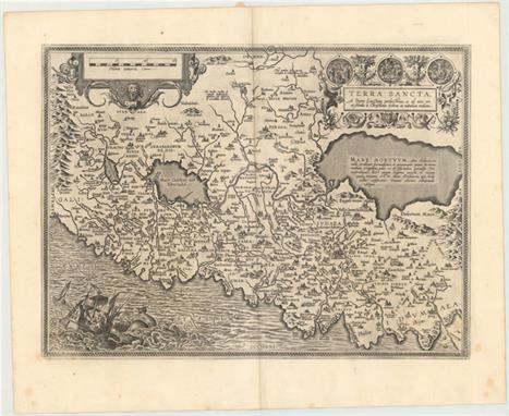
Ortelius, Abraham 1598 Terra Sancta, a Petro Laicstain Perlustrata, et ab eius ore et Schedis a Christiano Schrot in Tabulam Redacta This striking map is considered the most `modern` of Ortelius` maps of the Holy Land. It is a very detailed map, centered on Samaria, with north oriented to the left. The map was drawn by Christian Schrot with cartography based on Peter Laicksteen`s wall map describing his 1566 visit to the Holy Land. The elaborate title cartouche incorporates vignettes of the birth, crucifixion and resurrection of Jesus. The map is further adorned with a bold distance scale featuring the head of Medusa and a dramatic scene depicting Jonah falling from a ship into the waiting jaws of the whale. French text on verso with page number 112. 20" W x 14.5" H Watermarked paper with wide original margins and all edges gilt. There is light soiling along centerfold and several small, unobtrusive spots.

Jansson, Jan 1657 Tabula Itineraria Patriarcharum Abrahami, Isaaci et Iacobi A fine decorative map illustrating the travels of Abraham, Isaac, and Jacob, the Patriarchs of the Bible. The map is devoid of detail except in the regions described in the biblical accounts. It covers the region from Cyprus to Iraq and the great city of "Babel", and from Egypt to the deserts of Arabia. The decorations represent the bounty of the Promised Land with the title and scale cartouche adorned with a cornucopia of fruit and vegetables, and the imprint cartouche featuring a host of putti harvesting fruit and vegetables. 20.4" W x 14.8" H Nice impression and color with a repaired fold separation in bottom margin.
![Duval, Pierre 1677 [On 2 Sheets] Terra Sancta quae et Terra Chanaan, Terra Promissionis, Terra Hebreorum, Terra Israelitarum,](http://lot-images.atgmedia.com/SR/36385/2893812/574-2013117142632_468x382.jpg)
Duval, Pierre 1677 [On 2 Sheets] Terra Sancta quae et Terra Chanaan, Terra Promissionis, Terra Hebreorum, Terra Israelitarum, Iudaea, et Palestina... This large-scale map of the Holy Land is printed on two sheets and divides the region into the Twelve Tribes of Israel. It covers the region with the shoreline from Sidon to Gaza and inland to Syria and the Arabian Desert. A large inset map in the southern sheet shows the Nile Delta, Sinai and Canaan with the Wandering of the Children of Israel, titled "Peregrinatio et Mansiones Israel Itarum, in Deserto". The maps are filled with fine detail with a large title cartouche gracing the southern sheet, featuring Moses, Adam eating an apple in the Garden of Eden, and God atop a cloud. Size is for each sheet; if joined the map would measure approximately 20.9 x 30.5". 20.9" W x 15.4" H Watermarked paper with minor soiling.

Bachiene, Willem Albert 1750 De Beyde Koningryken Juda en Israel… This is a nice Biblical map of the kingdoms of Judea and Israel as they were during the reign of King Solomon. The map extends to include a large part of the Arabian Desert as well. Putti hold up the title cartouche and another adorns the distance scale. A large vignette depicts one of the battles of Solomon. Engraved by Jan van Jagen. 19.3" W x 14.9" H A somewhat light impression on watermarked paper with light toning along sheet edges.
![1850-70 [Lot of 2] The Holy Land at Successive Periods on the Same Scale [and] Geographie de la Bible "A. “The Hol](http://lot-images.atgmedia.com/SR/36385/2893812/584-2013117142652_468x382.jpg)
1850-70 [Lot of 2] The Holy Land at Successive Periods on the Same Scale [and] Geographie de la Bible "A. “The Holy Land at Successive Periods on the Same Scale”, by William Smith, from “Dr. William Smith`s Ancient Atlas”, circa 1870, printed color (22.7 x 17.1”). Eight maps on one sheet showing the shifting political divisions of the Holy Land at different periods in time. The maps cover from 1451 B.C. to A.D. 70, starting with the Holy Land “before the conquest,” and ending with the destruction of Jerusalem. Condition: Light toning along centerfold with a tiny surface tear at top center and centerfold separations at top and bottom that have been closed on verso with archival tape. (B+) B. “Geographie de la Bible”, by Alexander Vuillemin, circa 1850, hand color (16.7 x 13.5”). Four maps on one sheet showing the geography of different areas as mentioned in the Bible. The maps cover Palestine, the Herodian kingdom, and Canaan, and one depicts the travels of the Apostles Peter and Paul in the eastern Mediterranean and Holy Land. Engraved by Lemercier. Condition: A hint of offsetting and light toning along sheet edges. (A)" #VALUE! See description.

Sanson/Jaillot, 1692 L`Asie Divisee en ses Principales Regions, et ou se Peut Voir l`Estendue des Empires, Monarchies, Royaumes, et Estats qui Partagent Presentement l`Asie Originally a sculptor, Alexis-Hubert Jaillot began his career in map-making after marrying the daughter of Nicolas Berey. His skill as an engraver and his business acumen brought him to the attention of Nicolas Sanson`s heirs, who hired him to breath new life into their business at about the same time that Blaeu`s important printing works were destroyed by fire. Jaillot re-engraved Sanson`s important maps on an enlarged scale and published them first in Paris and later printed by Pierre Mortier in Amsterdam. This expansive map of Asia is one of the largest and most impressive general maps of the continent. It is based on Sanson`s 1650 map, but Jaillot updated the northeastern coastline from Duval`s map of 1670. The island of Hokkaido is attached to the mainland as part of the "Yupi" peninsula and a huge "Terre de Iesso" (the name normally associated with Hokkaido) appears to the east. Korea is shown as an elongated peninsula. In the East Indies, New Guinea is divided into "Terre de Papous" and "Nouvelle Guinee". Printed on two sheets and joined, as issued. 34.3" W x 21.5" H Issued folding, now pressed with creasing, light toning, and minor soiling. Short tears and chips in blank margins, and two tears at left and right that extend approximately 2" into map image, have all been professionally repaired. Backed in Japanese tissue to reinforce folds and repair several small holes at fold intersections.

Hondius/Bertius, 1618 Iava Maior This precisely engraved map shows the northern coastline with numerous place names, but the southern coastline is entirely conjectural. The map is handsomely adorned with two strapwork cartouches and a ship. French text on verso. 5.2" W x 3.8" H A nice impression with light show-through of text on verso and one small spot in distance scale cartouche.

Hondius/Bertius, 1616 Africa A reduced version of Hondius` superb map of the continent. It is based on the Mercator model with revisions to the coastlines, particularly that of Madagascar. Hondius improved the Cape area by inserting "C. Falco" and discarding Cayneca. In western Africa, the Niger River flows in a fairly straight line to the Atlantic, and two large lakes south of the equator are shown as the source of the Nile River. The map is crisply engraved and decorated with strapwork title and distance scale cartouches. Latin title page on verso. 5.3" W x 3.8" H A nice impression with attractive color and light toning.


-
186094 item(s)/page