We found 216134 price guide item(s) matching your search
There are 216134 lots that match your search criteria. Subscribe now to get instant access to the full price guide service.
Click here to subscribe- List
- Grid
-
216134 item(s)/page


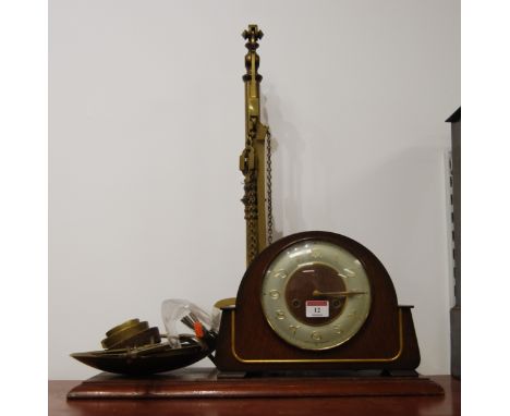
Lot 290
A rare 19th century mahogany cased regulator clock, by G. H. & C. Gowland, Chronometer Makers To The Admiralty, Sunderland, No 1858, the arched case with long glazed door set with an open carved decoration of flowers and scrolling leaves and a moulded outer frame, over a concave foot, access hatch to top of case, the 12.5" silvered dial with black Arabic five minute numerals, minute track, subsidiary seconds dial and twenty-four hour dial, the extremely substantial six pillar eight-day movement with deadbeat escapement, a mercury compensating pendulum supported on a large support mounted to the backboard, beat scale at base of case, with winder and weight, 47 by 25 by 175cm high.
Lot 352
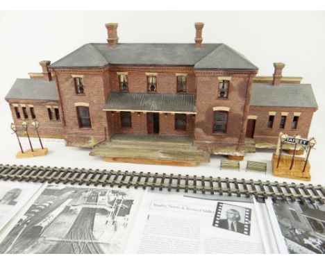
THIS LOT INCLUDES MODELS FROM THE VERY BIRTH OF 'O' GAUGE FINE SCALE RAILWAYS 'STROUDLEY' STATION BUILDING WITH WORKING SASH WINDOWS, TWO BRASS BENCH SEATS & SIX PLATFORM LAMPS all made for the famous Stanley Norris layout. Upon Walley Mayhew's acquisition he renamed it 'Stanley' in his memory, hence the inclusion of platform name board 'Stanley' together with four published sheets illustrating the provenance of this unique historic lot

Lot 655
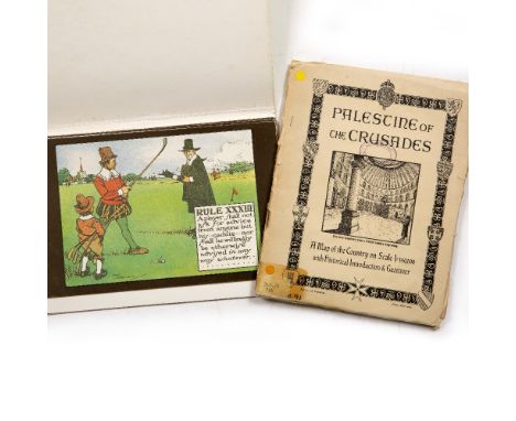
Palestine and the Crusades, A Historical Introduction and Gazetteer to Accompany a large fold out map under the direction of F.J. Salmon, Land and Surveys Palestine. Scale 1:350,000, 77 x 54cm approx. ex OCC Library with stamps together with 9 Pcs. The Rules of Golf after Chas Crombie, mod. reproductions (2)
Lot 835
Hollow Cast Metal Figures - an extensive late 1940's/early 50's small scale Trooping The Colours/Coronation procession, including lifeguards, Cavalry mounted, in blue and red dress livery, approx 48mm high, standing and walking Yeoman of the Guards, and figures stood at present arms, approx 37mm high, part diagonal cast England, possibly Crescent ToysNBThis set was arranged and on display for the 1953 Coronation in the vendors father's toy shop
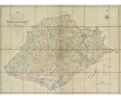
Lot 179
Windsor Forest. Walter (H.), To the Kings most Excellent Majesty This Map of Windsor Forest and its Vicinity from actual survey is humbly dedicated..., published August 1st by the Proprietor at Holyport near Maidenhead and E. Mogg London, 1st. edition, 1823, engraved large scale map with contemporary hand colouring, sectionalised and laid on linen, calligraphic cartouche, compass rose and table of explanation, near contemporary manuscript addition of railway lines and a pencil and watercolour plan of Chobham Common showing army encampments, slight staining and some dust and finger soiling, 920 x 1250 mm (Qty: 1)NOTESA rare separately published map of the environs of Windsor Forest from Staines in the West, Bagshot in the South, Twyford in the West and Maidenhead in the North. Walter is not recorded in Worms and Baynton-Williams. Copac lists only two institutional copies (British Library and Oxford University) and Worldcat only one (British Library).
Lot 156
* Poland . Senex (John), Poland Corrected from the Observations Communicated to the Royal Society of London and the Royal Academy at Paris..., [1720 and later], engraved map with contemporary hand colouring, large uncoloured cartouche and mileage scale, slight creasing, occasional marginal repaired closed tears, 650 x 950 mm, mounted with another later edition with contemporary outline colouring and some later enhancement to the cartouche and mileage scale, double aperture mount, framed and glazed (Qty: 1)
![South West England. Gloucestershire. Saxton (Christopher & Hole G), Glocestriae comitatus olim sedes Dobunorum, [1637], h](https://cdn.globalauctionplatform.com/45651768-0840-4e6b-a25a-ab4401107d4e/70322d97-49e7-4bdc-b62b-ab45010719df/468x382.jpg)
Lot 172
South West England. Gloucestershire. Saxton (Christopher & Hole G), Glocestriae comitatus olim sedes Dobunorum, [1637], hand coloured engraved map, large ornate cartouche, mileage scale and compass rose, toned overall, occasional marginal closed tears, 285 x 315 mm, together with Saxton (Christopher & Kip William). Dorcestriae comitatus vulgo Dorset..., circa 1610, hand coloured engraved map, large strapwork cartouche, mileage scale and compass rose, small margins, laid on later card, 275 x 385 mm, with another six county and road maps of Dorset, Cornwall, Somerset and Gloucestershire, including examples by Conder/Hogg, Owen & Bowen, Badeslade & Toms, De La Rochette and Archer, various sizes and condition (Qty: 8)
![* England & Wales. Ortelius (Abraham), Angliae Regni florentissimi nova descriptio auctore Humfredo Lhuyd..., [1602], han](https://cdn.globalauctionplatform.com/45651768-0840-4e6b-a25a-ab4401107d4e/cfdd08aa-08ee-4304-865a-ab450106dd0c/468x382.jpg)
Lot 113
* England & Wales. Ortelius (Abraham), Angliae Regni florentissimi nova descriptio auctore Humfredo Lhuyd..., [1602], hand coloured engraved map, large strapwork cartouche and mileage scale, several repaired marginal closed tears, some staining caused by old tape repair, central fold strengthened on verso, some creasing, 375 x 470 mm, mounted, framed and double glazed (Qty: 1)NOTESMarcel van den Broecke, Ortelius Atlas Maps, 19.
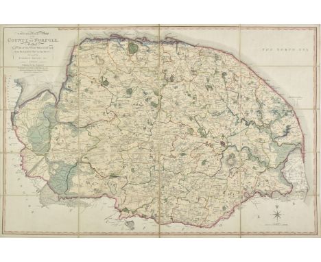
Lot 117
Folding County Maps. Milne (Thomas), A Topographical Map of the County of Norfolk reduced by a scale of Two Statute Miles to one Inch from the Large map in six sheets..., published W. Faden, 1803, engraved map with contemporary outline colouring, sectionalised and laid on linen, 590 x 890 mm, contained in a contemporary marbled card slipcase with publisher's printed label to upper cover, case worn and frayed, together with Dix (Thomas). A New Map of the County of Gloucestershire, Divided into Hundreds, published W. Darton, 1830, uncoloured engraved map, sectionalised and laid on linen, circular cartouche, mileage scale, compass rose and vignette of Tewkesbury Church, slight staining, 455 x 365 mm, contained in a contemporary marbled card slipcase with publisher's printed title label to upper cover case worn and frayed, with Cary (John). A New Map of Cornwall Divided into Hundreds exhibiting its Roads, Rivers, Parks &c., 1828, engraved map with bright contemporary outline colouring, sectionalised and laid on linen, oval cartouche, inset map of the Scilly Isles, 485 x 550 mm, marbled endpapers, contained in a contemporary marbled card slipcase with printed title label to upper cover, plus Hall (Sidney). Berkshire [and] Oxfordshire, circa 1850, two engraved maps with contemporary outline colouring, sectionalised and laid on linen, each approximately 195 x 250 mm, contemporary cloth gilt boards, and Walker (J. & C.). Kent [and] Wiltshire, 1835 & 1846 respectively, two engraved maps with contemporary outline colouring, sectionalised and laid on linen, map of Kent stained and dust soiled, each approximately 400 x 330 mm, bound in contemporary cloth boards with printed label to upper cover, with two folding fox hunting maps of Oxfordshire and South West England, various sizes and condition (Qty: 9)
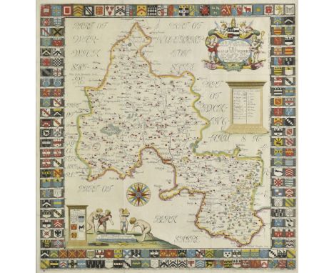
Lot 144
Oxfordshire. Plot (Robert), The Map of Oxfordshire..., circa 1677, hand coloured engraved map, decorative cartouche, mileage scale, compass rose and table of explanation, old folds, a few folds repaired on verso, 500 x 480 mm (Qty: 1)NOTESCreated by the first keeper of the Ashmolean Museum of Oxford and decorated with 172 coats of arms of the county's gentry, Oxford colleges, the city and the four county towns. One of the most decorative maps of Oxfordshire ever produced.
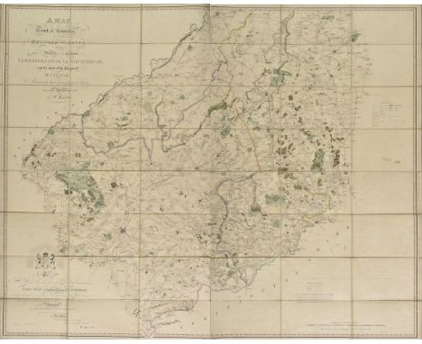
Lot 126
King (William). A Map of a Tract of Country Surrounding Belvoir Castle including extensive Districts of the Counties of Leicester, Lincoln & Nottingham; and the whole of the County of Rutland. Accurately laid down from a Survey taken in the years 1804. 5. & 6. engraved and sold by W. Faden, published Knipton, Nov. 8th, 1806, large scale engraved map with contemporary outline colouring, sectionalised and laid on linen, calligraphic title and dedication and mileage scale, slight dust soiling and very slight spotting, 1150 x 1440 mm, map seller's label (W. Faden) to verso, lacking slipcase (Qty: 1)NOTESUncommon.
![Northamptonshire. Smith (William), Northamptoniae Comitatus Descriptio....., J.Overton [1675 or later], hand coloured engrave](https://cdn.globalauctionplatform.com/45651768-0840-4e6b-a25a-ab4401107d4e/d0a8ff04-dd4f-4ed1-a96b-ab450106f289/468x382.jpg)
Lot 139
Northamptonshire. Smith (William), Northamptoniae Comitatus Descriptio....., J.Overton [1675 or later], hand coloured engraved map, large strapwork cartouche and mileage scale, toned overall, 365 x 480 mm (Qty: 1)NOTESWilliam Smith, antiquary and cartographer, was a contemporary of Christopher Saxton. He only completed twelve maps which were probably intended for an uncompleted English atlas. The maps were individually first published in 1602, and the plates were acquired by John Overton in 1670. Until comparatively recently their authorship was doubtful and they were known as the 'Anonymous Maps'. All of Smith's maps are considered scarce.
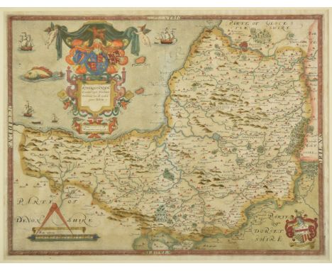
Lot 170
* Somerset. Saxton (Christopher), Somersetensem Comitat (agri fertiltate Celebrem) hec ob oculos ponit Tabula. Anno 1575. et D.Elizabethe Regine Ao 17, [1579], engraved map with contemporary hand colouring, ornate heraldic and strapwork cartouche and mileage scale, with the arms of Thomas Seckford in the lower right corner, 395 x 520 mm (Qty: 1)NOTESPublished in 'An Atlas of England and Wales', this is a fine example of a map from the first complete English atlas. Saxton was a Yorkshireman who was educated at Cambridge and attached to the household of Thomas Seckford at whose instigation and expense and with the Authority of Queen Elizabeth, he surveyed and drew the first county maps of the Kingdom. The map was engraved by Lenaert Terwoort whose name appears beneath the mileage scale. T.Chubb. Maps of Somerset 1579 - 1914, no.1.
Lot 142
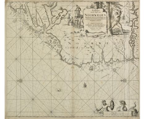
Norway. Van Keulen (Johannis), Paskaart van de Kust van Noorwegen Beginnende van de Wtweer Klippen tot aan Swartenos..., & Paskaart van de Kust van Noorwegen Beginnende van Swarten Os tot aan Heyligelander Leen.., circa 1681, together two uncoloured engraved sea charts, the first orientated to the west, the second to the south, large allegorical cartouche and mileage scale, slight marginal fraying, slight toning to central fold, each approximately 515 x 585 mm (Qty: 2)
![Newbury. Willis (John), [A Map of the] Country Ten Miles round Newbury in Berkshire, with a Plan of Newbury and Speenhamland,](https://cdn.globalauctionplatform.com/45651768-0840-4e6b-a25a-ab4401107d4e/9cc4c578-fe0e-48d4-aa02-ab450106f13c/468x382.jpg)
Lot 137
Newbury. Willis (John), [A Map of the] Country Ten Miles round Newbury in Berkshire, with a Plan of Newbury and Speenhamland, 1768, large scale engraved circular map with contemporary outline colouring on four conjoined sheets, inset town plan of Newbury, miles shown as concentric circles from Newbury in the centre, laid on later linen, old folds, heavily frayed and worn with some loss to margins and title, some dust soiling, creasing and repaired closed tears, 990 x 1345 mm (Qty: 1)NOTESRare. Copac lists three copies, held by The British Library and Oxford and Cambridge University.
Lot 146
* Poland & Lithuania. Blaeu (Willem Janszoon), Magni Ducatus Lithuaniae Caeterarumque Regionum illi Adiacentium Exacta Descriptio..., [in set with] (Dnieper River), Amsterdam, 1613 - 1635, wall map, engraved by Hessel Gerritsz from drafts prepared by Prince Nicolas Radziwill, contemporary outline colouring, on four conjoined sheets, showing Lithuania and parts of Poland, Russia, Ukraine and Latvia, extending to Cracow, Kiev, Warsaw, Riga, Konigsberg, Dantzig and Leopolis, 750 x 740 mm, mounted with its companion sheet showing the course of the River Dnieper, this map on two conjoined sheets with contemporary outline colouring, old folds, 750 x 325 mm, double aperture mount, framed and glazed (Qty: 1)NOTESThe first map provides a great deal of information on cities and towns of all sizes, political boundaries, and the extensive system of rivers in the region. Also included are a number of historical notations and two vignettes illustrating important battles west of Smolensk and between Braclaw (Bratslav) and Cherkasy (at bottom right). The map is decorated with several cartouches, three galleons and a sea monster in the Baltic Sea, a large compass rose, and a distance scale. The map detailing the course of the Dnieper River extends from Cherkasy to the estuary on the Black Sea. The map is in two vertical strips which follow the course of the river. It is decorated with cartouches and compass roses and includes descriptions of cataracts, cities, salt mines, fortresses, and the historical traditions of the Kozaks. The large cartouche at the base of the map is flanked by putti. It is rare to find the two maps together and extant.
Lot 256
A set of three oak reclining chairs, two with low backs, the other higher, lacking baton, all lacking seats, 78cm wide 91.5cm deep 62cm high seat 32cm high (82 and 107cm high backs), together with a small 1/7 scale model of the chairs (4) By repute made locally by a boat builder in Bosham in West Sussex where MJ Long had a cottage. Provenance: The Estate of MJ Long.
Lot 134
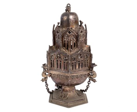
A replica of a medieval censer, probably Spanish, 19th century, the upper part in two architectural tiers with cupola like top from which the main chain is suspended, the hexagonal bowl with scale ornament, 27cm high/Provenance: Spetchley Park/see illustration CONDITION REPORT: 134:Chains intact. Cherub finial a little pushed in. Five small pinnacles have come off upper section. Minor wear and bends in line with age and usage.

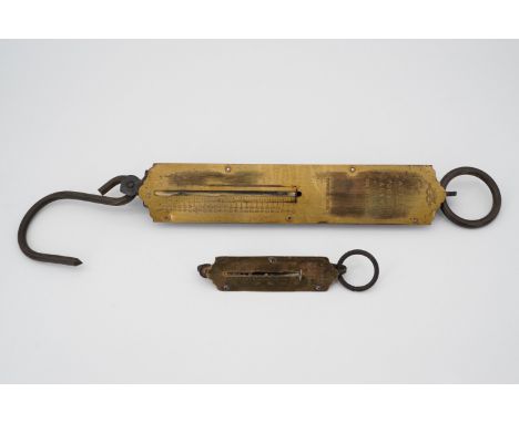
Lot 186
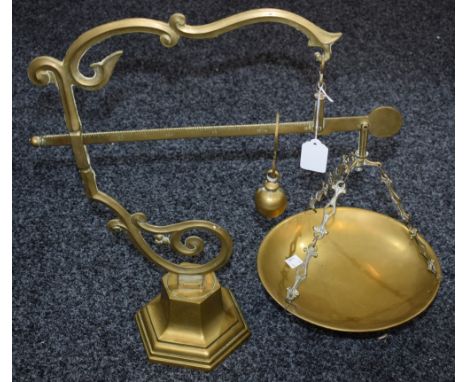
Vintage scale with bowl and some weights, pair of wooden bellows, binoculars, table lamp, pipe holder with pipes, Minton 'Haddon Hall' part tea service, a Royal Worcester white, cream and gilt decorated lidded tureen, Schweppes soda syphon, assorted glassware, assorted other ceramics and a quantity of commemorative ware including teapot for the Silver Jubilee for 1910-1936, etc (5 boxes, scales and tureen)
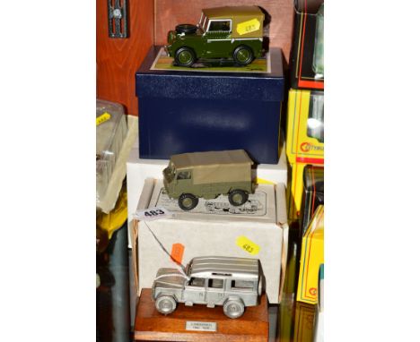
Lot 483
A BOXED HART MODELS FORWARD CONTROL 1 TONNE GS MILITARY LAND ROVER, No.HT41, 1/48 scale white metal and resin model, with a boxed Britains Collectibles Vintage Farm Land Rover Series 1, No.08735 and an unmarked white metal model of a Land Rover 110 on a wooden plinth, first two in very lightly playworn condition, look to have hardly ever been removed from boxes (3)
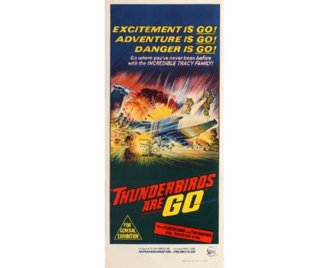
Lot 460
Original vintage movie poster for the Australian release of the British science fiction adventure film Thunderbirds Are Go - Excitement is Go! Adventure is Go! Danger is Go! Go where you've never been before with the incredible Tracy family! - based on the 1960s Thunderbirds children's television series using marionette puppets and featuring scale model effects in a filming process known as Supermarionation; this film version was written by Thunderbirds creators Gerry and Sylvia Anderson and directed by David Lane. Colourful sci-fi style illustration showing the futuristic spaceship Zero X crash landing onto the small town of Craigsville in Florida with the title below in stylised red and yellow letters. Printed in Australia by Robert Burton Pty., Ltd., Sydney. Very good condition, folded as issued, minor tears and creases in margins. Country: Australia, year of printing: 1966, designer: Unknown, size (cm): 76x34

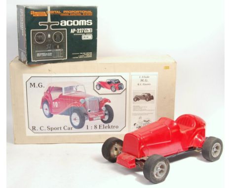
Lot 52
A rare vintage 1970's Yu-Can made 1/8 scale Radio Controlled Sports Car. Made In Holland. Fitted with full Acoms radio gear, and electric motor. Transmitter within its original box. Along with another Yu-Can ' MG Sports Car ' boxed kit - with contents (unchecked) and a small quantity of parts / spares. Rare vintage RC Cars, made to rival Tamiya.
-
216134 item(s)/page