We found 216136 price guide item(s) matching your search
There are 216136 lots that match your search criteria. Subscribe now to get instant access to the full price guide service.
Click here to subscribe- List
- Grid
-
216136 item(s)/page

![A FINE 16FT:1IN. SCALE ADMIRALTY RECRUITING OFFICE WATERLINE MODEL OF H.M.S. CORUNNA [1945] AS RE-FITTED IN 1962 AS PART OF T](https://cdn.globalauctionplatform.com/975693c8-efdd-4074-977a-a74e00eb4475/67696bd9-f399-480b-d9d9-d54e1716c072/468x382.jpg)
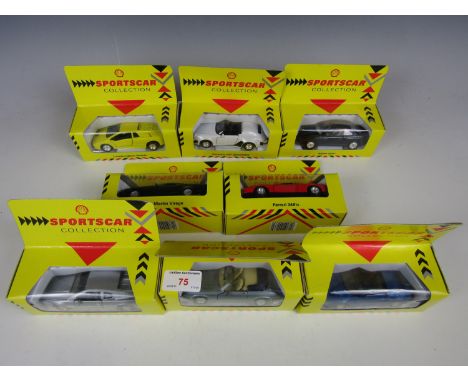
Lot 314
A FINE 16FT:1IN. SCALE ADMIRALTY RECRUITING OFFICE WATERLINE MODEL OF H.M.S. CORUNNA [1945] AS RE-FITTED IN 1962 AS PART OF THE RADAR PICKET SYSTEM, modelled by Julian B. Glossop with carved laminated hull plated with paper and painted, detailed wood and metal fittings including main and secondary armament and central radar/missile control turret, fitted boats and launches in davits and much other fine detailing, depicted sitting in a calm green sea display base with dual detail plaques and maker's label inscribed Julian B. Glossop / Model Maker to the Admiralty, glazed wooden cover -- 13 x 32 x 11½in. (33 x 81.5 x 29cm.), A 'Battle' Class destroyer built at Swan, Hunter & Wigram, Corunna's keel was laid in 1943 but she was not launched until after hostilities in Europe had finished on 29th May 1945 and so was not commissioned until June 1947. Deployed in the Suez crisis of 1956, she was later one of four vessels selected for conversion to a Radar Picket which also included enhanced armament including the new Seacat Missile system. Placed in reserve in 1967, she was broken at Blyth in 1975. Julian B. Glossop began working with Norman Ough and this model is very similar to Ough's style.
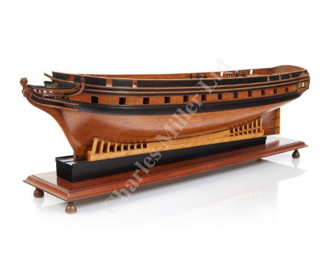
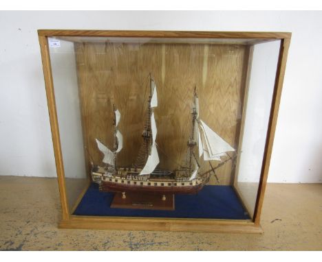
Lot 315
Ø AN HISTORICALLY INTERESTING 1:48 SCALE MODEL FOR THE CELEBRATED THREE-MASTED ARMED YACHT FALCON, BUILT FOR LORD YARBOROUGH, FIRST COMMODORE OF THE ROYAL YACHT SQUADRON, BY LISTS YARD, ISLE OF WIGHT, 1824, the framed hull planked and pinned with copper pins, moulded ebony main wale, main deck pierced for twenty-four guns, finely carved bust-length female figurehead, stern and quarter lights, planked and pinned deck, mounted on slipway brackets attached to mahogany plinth with turned feet. Overall measurements -- 12 x 33in. (30.5 x 84cm.); together with a contemporary watercolour portrait historically associated with the model and, by hearsay, thought to be one Robert Butler, in period frame -- 17 x 15in. (43 x 38cm.) including frame, (2) Provenance: Sotheby's, 16 July 1993, lot 498, where attributed as a merchant ship; UK Private Collection. The second yacht to bear this name for him, Falcon (II) was launched in June 1824 for Lord Yarborough at a cost of £18000 (nearly £1.1m today) in List's yard at Wootton Bridge, Fishbourne, Isle of Wight. Though designed as a private yacht, her full-rig and general appearance prompted one spectator to remark that she more resembled a "20-gun ship-of-war" and she undoubtedly proved a highly impressive flagship to the Royal Yacht Squadron, a role she fulfilled for over ten years. It is notable that one of the main objectives of the R.Y.S.'s pioneers - and of far greater importance than the annual regatta at Cowes - was to improve the form and sailing qualities of warships and to that end, Falcon was the most successful of several experimental craft of her time. Yarborough, the Royal Yacht Squadron's first commodore, was a particularly colourful character in the early history of yachting and employed fifty-four "choice" hands under the command of a naval officer to crew Falcon whenever she raced. A serious accident at sea followed by illness prompted Lord Yarborough to dispose of Falcon and in 1836 she was sold to Captain Clifton on whose behalf Baring Brothers had financed the purchase for £5,500. Fitted with 48hp. paddle propulsion, she sailed for India in January 1838 but had the engine removed upon her arrival at Calcutta when she was resold to Jardine, Matheson & Co. Her new owners put her straight onto the opium run to Macao where her speed enabled her to continue trading throughout the so-called 'Opium War' of 1840-42. This acknowledged speed merely added to her lustre as flagship of the Jardine fleet and once the War was over, her main port of discharge became Hong Kong following the island's acquisition by British troops in 1841. Remaining a frequent sight all along the opium route until the mid-1850s, the end of her career remains shrouded in mystery. Said by some to have been taken by mutineers and by others to have been scuttled by pirates, there is circumstantial evidence that she was wrecked off Breaker Point, a projecting headland 60 miles South of Swatow, although this has never been proven. Recent research by Julian Reid has shed what may be a rare contemporary reference to this model: In 1825 Mr Belsey charged £15 for "a ship's model", perhaps for the use of the builder of Falcon II. Whilst it can now only be speculated upon, it seems highly probable that this is the model referenced. Literature: Reid, J: Original Members of the Yacht Club, Historical Publications Ltd, 2015, p.139-140.; MacGregor, D: Fast Sailing Ships 1775-1875, Conway, 1973 & 1988, p.71-75. Charles Miller Ltd is grateful to Ian McLaughlan for suggesting this attribution.


![Stanford (Edward, Publishers) Ordnance Survey [Map] of Yorkshire, 1865, London, E. Stanford, complete in seven parts with ou](https://cdn.globalauctionplatform.com/135cbed6-2ea5-4f55-bfb2-a73d00f710c4/e1a5778d-abf3-4fd2-ab5d-6a13f687d7ce/468x382.jpg)
Lot 73
Stanford (Edward, Publishers) Ordnance Survey [Map] of Yorkshire, 1865, London, E. Stanford, complete in seven parts with outline colour by hand, each sectionalized and on linen, varying open dimensions but all folding to 8vo size, and each with marbled e.p.s, and bookplate label for C.J. Peacock; (bumped and rubbed) red cloth box with publisher's label preserved (lacking lid). Scale one inch to one mile. Scattered soiling and staining, the maps generally well preserved, without significant loss. The first OS map of the whole ceremonial county (8)
![Ortelius (Abraham) and Lhuyd [Llwyd] (Humphrey) [Map of England and Wales] Angliae Regni Florentissimi Nova Descriptio, Aucto](https://cdn.globalauctionplatform.com/135cbed6-2ea5-4f55-bfb2-a73d00f710c4/935d5399-75dc-491d-96b0-9aa529acc2f2/468x382.jpg)
Lot 75
Ortelius (Abraham) and Lhuyd [Llwyd] (Humphrey) [Map of England and Wales] Angliae Regni Florentissimi Nova Descriptio, Auctore Humfredo Lhuyd Denbygiense, [1574 or later, Antwerp], engraved map with fine early colour by hand, elaborate strapwork cartouche and mileage scale, plate 380 x 470mm; Latin text with hand-coloured historiated initial to verso Centrefold, margins visible outside platemark, some very minor blemishes and stains; unexamined out of modern frame
Lot 59
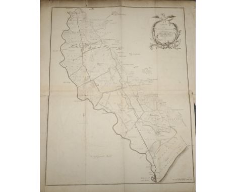
Bower (A., Surveyor) The Two Acts of Parliament for the Holderness Drainage with an Index and Plan. 1781, York, A. Ward, folio, 480 x 375mm, title, Index, xvi, pp. 20, the letterpress in two columns followed by several tables, two blank leaves preserved at rear (detached); the block loosely bound by original stitching (title almost detached), the laid paper rather browned, soiled and stained, with tatty extremities, and pp. 15-20 with hole to centre; with Bower's (disbound) folded map 'A Plan of the Holderness Drainage', engraved by Consitt at York, separately dated 1781, the floral cartouche surmounted by an eagle, sheet approx. 825 x 650mm. Scale of Chains lower right. Rather tatty extremities, some soiling and light foxing with some folds splitting at margins. The whole offered with remains of original leather-covered portfolio boards. No sale records nor institutional copy of this very scarce work traced (1)
Lot 72
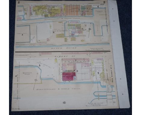
Goad (Charles E.) Insurance Plans of Goole Yorkshire, March 1896 (-1911), London, Goad, two complete sets of three lithographed plans, comprising Key Plan (sheet 1) and sheets 2 - 3, with additional duplicates of 2 and 3, forming in total eight plans on six large folio sheets (loose, each c.640 x 540mm), all but two hand-coloured. Some plans pasted back to back on linen mounts. The plans, giving details such as street names, building numbers, number of storeys, as well as usages and ownership, have been updated using overlays and show revisions to March 1911. Scale of key plan 400 feet: one inch; other plans 40 feet: one inch. The usual signs of use and soiling and staining, with small tears and nicks to extremities, without loss. These are the only sets of Goad's plans for Goole extant (6)
Lot 68
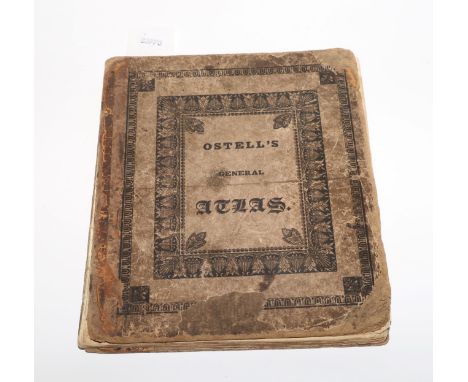
WORLD ATLAS Ostell's New General Atlas; containing Distinct Maps of all the Principal States and Kingdoms throughout the World...A New Edition, 1826, London, Baldwin, Craddock and Joy, 4to, publisher's printed pasteboards, detached; titlepage, Contents with publisher's advert to verso, 30 engraved maps by J.C. Russell (complete), hand-coloured in outline. The two world maps are double-page. Boards very rubbed, scuffed and soiled, with frayed extremities, lacking spine, first gathering detached from block; the plates with marginal foxing and finger-soiling, the first map (The World) with hole outside image, ink stains and splitting fold; ink inscription to front pastedown. A scarce atlas in this edition, printed from 'a set of entirely new plates, on an enlarged scale'
Lot 130
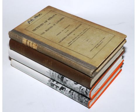
COAL MINING and GEOLOGY Hull (Edward) Vertical Section of the Formations over the Western District of S. Lancashire, showing the succession of Strata from the New Red Sandstone, through the Permian Rocks… (for Wigan and St. Helen's Districts), Sheet No. 27, 1861, Geological Survey of Great Britain; engraved diagram by J.W. Lowry, sectionalized and mounted on linen, the darkest layers indicating seams of coal, 975 x 665mm; scale 40 feet to one inch, some soiling and time-staining, unexamined out of modern black frame [with:] Hollinshead Blundell (R.B.B.) Plan of Blackrod Colliery [near Wigan, Lancs.], n.d., 19th century pen and ink with outline colour by hand, compass rose and Scale of Yards, 650 x 920mm; creases, closed tears, soiling and staining; unexamined out of modern frame [plus:] three 8vo books on mining, viz. Dines (H.G.) The Metalliferous Mining Region of South-West England, 2 vols, 1956 (1969 second impression), d.j.s; Hickling (G.) Sections of Strata of the Coal Measures of Lancashire, 1927; Wilcockson (W.H.) Sections of Strata of the Coal Measures of Yorkshire, Third edition, 1950 (5)
Lot 79
IMPORTANT MAP OF DERBYSHIRE Burdett (P.P.) To The Right Honourable The President, Vice-Presdient…of the Society for the Encouragement of Arts, &c, This Survey of Derbyshire, Began in the Year 1762, and finished in the Year 1767… [c.1767], London, Kitchin and Derby, Burdett. Large engraved map on six sheets laid on linen, partly hand-coloured in outline; rococo cartouche, inset plan of Derby and trigonometry diagram, vignette of rocks lower left. The paper c.1550 x 1040mm, scale one inch to one mile. The expected age-toning and cockling/crinkling to the paper, the extremities tatty and chipped, with a few mostly small tears into the plate (one c.20cm from the top); spots of mould and associated soiling to right margin, getting more pronounced into lower right corner. No loss within printed border. Peter Perez Burdett's map of Derbyshire won him the £100 premium (prize) offered by the Society of Arts to encourage accurate county mapping. He later published the first aquatint in England, and sold his new process to Paul Sandby. A fine draughtsman and noted expert in perspective, he was the first President of the Liverpool Society of Arts and exhibited in London at the Society of Artists. His Derbyshire acquaintances included Joseph Wright, who painted a fine portrait of Burdett and his first wife, Hannah (in the Národní Galerie, Prague). Burdett left for Germany to escape his debts in 1774, working for the Margrave of Baden as surveyor, never to return to England. A scarce example of the first edition of this map, which very rarely appears on the market
-
216136 item(s)/page