We found 186097 price guide item(s) matching your search
There are 186097 lots that match your search criteria. Subscribe now to get instant access to the full price guide service.
Click here to subscribe- List
- Grid
-
186097 item(s)/page


Lot 569
A Japanese white metal and enamel okimono of a dragonMeiji period, unmarkedThe beast tightly coiled, each scale and whisker finely detailed, with an attached flame enamelled green, 6.5cm high.Condition Report: A couple of tiny losses to extremities. Two small holes to the back of the dragon, suggesting it may have had a further flame originally. Expected surface wear otherwise good.


![* China. Ortelius (Abraham), Chinae olim Sinarum regionis nova descriptio, auctore Ludovico Georgio, Antwerp [1592 or later],](https://cdn.globalauctionplatform.com/dd84a124-1580-49ca-a704-b13201270f77/ac2c29d0-b8fc-416b-9102-b16200a8bda7/468x382.jpg)
Lot 121
* China. Ortelius (Abraham), Chinae olim Sinarum regionis nova descriptio, auctore Ludovico Georgio, Antwerp [1592 or later], hand-coloured engraved map, orientated to the west, large strapwork cartouche and mileage scale, good margins, 370 x 470 mm, mounted, framed and double-glazed, Latin text on versoQTY: (1)NOTE:Marcel van den Broecke. Ortelius Atlas Maps, number 164. A fine copy of the first European map of China being the second state with “Les Philippinas” inserted above “Sinus Magnus”.
Lot 53
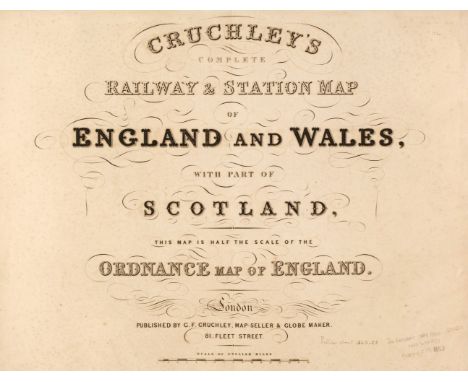
Cruchley (G. K. publisher). Cruchley's Complete Railway & Station Map of England and Wales, with Part of Scotland, This Map is Half the Scale of the Ordnance Map of England, circa 1860, double-page calligraphic title, index map and 65 (complete as index map) engraved double-page maps, all with contemporary wash colouring, index maps and sheets 1, 2, 3, 10 and 19 with repaired closed tears, some affecting the printed image, additional unattributed railway map of Scotland tipped in before the title page, later endpapers, later half cloth over contemporary boards with contemporary morocco gilt title label to the upper siding, worn and stained, folioQTY: (1)
Lot 228
* Prints & Engravings. A collection of approximately 575 prints, mostly 19th-century, engravings, etchings and lithographs including British topographical views, natural history, advertisements, foreign topography, pencil drawings, genre, greetings cards, sporting and caricatures (Dr Syntax series), together with a partially excised scrap album containing greetings cards, scraps, drawings and photographs, with Saxton (Christopher & Hole G.). Glocestriae Comitatus olim sedes Dobunorum [1607 - 10], hand - coloured engraved map, large strapwork cartouche and mileage scale, slight creasing, 285 x 320 mmQTY: (approx. 575)
Lot 137
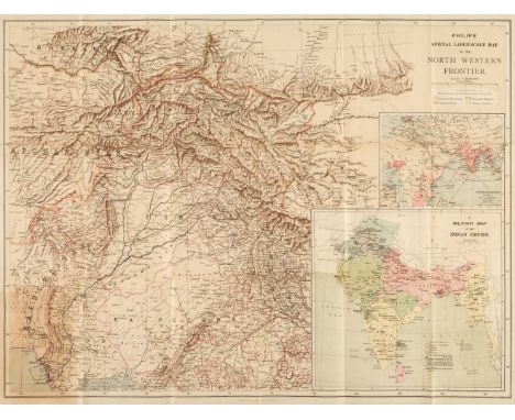
Folding maps. A collection of 6 folding maps of foreign parts, mostly 19th-century, including Philips's Special Large Scale Map of the North Western Frontier with a map of the Overland Routes and a Military Map of the Indian Empire, George Philip & Son, London & Liverpool, circa. 1897, folding colour lithographic map, lightly toned, laid on linen, folded in original printed cloth wrappers, 550 x 725 mm, together with:Stanford's Map of The Far East & Pacific Ocean to illustrate the international situation..., mandated territories are shown according to the latest information available, London: Edward Stanford, 1941, folding colour photolithographic map, pinholes to upper corners of margins, laid on linen, original wrappers to verso, 550 x 700 mm, plus Bartholomew's War Map of Afghanistan and the indo-Russian frontiers, with a large general map showing the connection between England, Russia, & India, Edinburgh: John Bartholomew, 1885, folding colour lithographic map, a few tears and holes to folds, original wrapper to verso, 830 x 615 mm, plusPhilip's Special Large Scale War Map of The Soudan, Extending to Suakim on the Red Sea, with an enlarged plan of Kharetu, London: George Philip & Son, 1885, folding colour lithographic map, printed in black and blue, some spotting, a few tears to folds, original wrapper to verso, 575 x 795 mm, plusMap of British Malaya including the Straits Settlements, Federated Malay States and Malay States not included in the Federation...., Published under the direction of the Surveyor General, 1924, folding colour lithographic map, light spotting, area of loss to top left corner, laid on linen, 915 x 880 mm, and Town of Accra, circa. 1930, folding colour lithographic map, a few pencil annotations to printed area, margins and manuscript title to verso, light toning, 900 x 450 mm QTY: (6)
Lot 165
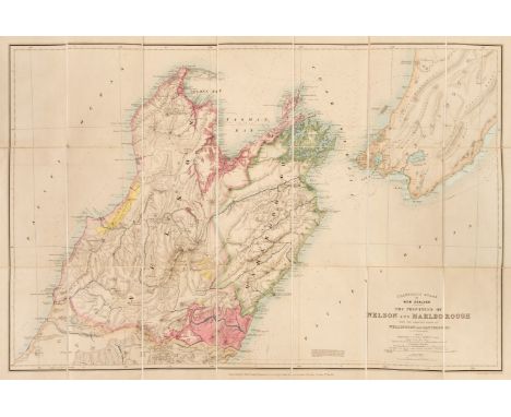
New Zealand. Stanford's Atlas of New Zealand, the Provinces of Nelson and Malbrough with the adjacent parts of Wellington and Canterbury..., London, published by Edward Stanford..., 2nd of May 1864, large scale engraved map with contemporary hand colouring, sectionalized and laid on linen, minor spotting to a few areas, folded into original brown cloth boards (a little water stained and faded), 660 x 970 mm, plusGeorge Philip & Son (Publisher). New Zealand, London, Philip-Stanford Authentic Reference Maps, 1957, colour printed folding map in original printed paper wrappers, a few minute holes to folds, 710 x 560 mm and 3 other large colour printed folding maps including; South Island, New Zealand, 1st Jan 1957, Map of Christchurch and Environs, 1957 and Map of Wellington and Environs, 1960, all published by the Lands & Survey Dept, under the authority of R. G. Dick, Surveyor-General, with light dust soiling and minute holes to folds, various sizes, together with: Hewitt (Nathaniel Rogers). A collection of maps of engraved maps printed for Grant & Griffith (successors to J. Harris), circa. 1848 with original hand-colouring consisting of; Map of the World (folding, long closed tear, sheet size 220 x 380 mm), fictional map providing examples of topographical features, Europe (with contemporary ink manuscript annotations), Asia, Africa, North America, South America, England and Wales, Scotland and Ireland, each approximately 220 x 280 mm (sheet size), most maps with a little dust soiling and a few ink spots, all loosely stitched together QTY: (6)NOTE:It is highly likely that the collection of Hewitt maps were the exercise sheets to accompany William Butler's Geographical and Biographical exercises, designed for the use of young ladies, Grant & Griffith, 1848.

Lot 119
* China. Coronelli (Vicenzo Maria), Xantung e Peking Provincie della China...., Venice, circa 1690, hand-coloured engraved map, decorative cartouche and mileage scale, 450 x 600 mm, mounted, framed and glazedQTY: (1)NOTE:One of seven provincial maps of China, published by Coronelli in the Corso Geografico Universale.

Lot 112
British Isles. Jaillot (Alexis Hubert), Les Isles Britannique qui contiennent les Royaumes d'Angleterre Escosse, et Irlande..., Amsterdam [1696], engraved map with contemporary outline colouring, inset map of the Shetland Islands, large uncoloured allegorical cartouche and mileage scale, central fold partially split with some creasing, narrow margins, slight staining, 500 x 605 mm, together with Kitchin (Thomas). An Accurate Map of England and Wales Drawn from all the Particular Surveys..., J & C Bowles & Robert Sayer, circa 1765, engraved map with contemporary outline colouring, large uncoloured allegorical cartouche, slight marginal fraying and dust soiling, 600 x 515 mm, plus Sayer (Robert). A Compleat Map of the British Isles or Great Britain and Ireland; with their respective Roads and Divisions, 1772, engraved map with contemporary outline colouring, large margins, 620 x 490 mm, with another copy similar, and another five maps of the British Isles, England and Wales and regions, including examples by or after Wells, Moll, Thomson and Overton, various sizes and condition QTY: (12)NOTE:R. W. Shirley. Printed Maps of the British Isles 1650 - 1750 Jaillot 4 state 2,

Lot 114
British Isles. Janvier (Jean), Les Isles Britanniques Comprenant les Royaumes D'Angleterre, D'Ecosse et D'Irlande, Divisés en Grandes Provinces, Subdivisés par Comtés, Dressés sur les Observations Astronomiques, published Venice, circa 1780, engraved map with contemporary outline colouring and some later enhancement, inset map of the Orkney and Shetland Islands, 470 x 645 mm, together with De Lisle (Guillaume). Les Isles Britanniques ou sont le Royaumes d'Angleterre, tiré de Sped celuy d'Ecosse tiré de Th. Pont et celuy d'Irlande tiré de Petti..., J. Covens & C. Mortier, Amsterdam, circa 1760, engraved map with contemporary outline colouring, title repeated above the map in Latin, large uncoloured decorative cartouche and mileage scale, 480 x 580 mm, with Elwe (Ian). Les Isles Britannique qui contiennent les Royaumes d'Angleterre, Ecosse et Irlande..., Amsterdam, 1792, engraved map after A. H. Jaillot with contemporary outline colouring, inset map of the Shetland and Orkney Islands, large uncoloured cartouche and mileage scale, 475 x 595 mm, plus Laurie (Robert & Whittle James). The British Isles or the Coasts of Great Britain and Ireland..., 12th May 1794, uncoloured engraved map, large margins, some staining, 460 x 605 mm, and Lopez (Tomás). Mapa Geográfico de Las Islas Británicas, que comprehende Los Reynos de Inglaterra, Escocia é Irlanda, Madrid, 1789, engraved map with contemporary outline colouring, inset map of the Faroe and Shetland Islands, old folds, slight wear where old folds cross, repaired on verso, 480 x 585 mm, with Mannert (Konrad). Grosz-Britannien und Ireland..., Nuremberg, 1795, engraved map with contemporary wash colouring, inset map of the environs of London, old folds, some spotting, 740 x 540 mmQTY: (6)
![* East Indies. Jansson (Jan), Indiae Orientalis Nova Descriptio, Amsterdam [1635 or later], hand-coloured engraved map, decor](https://cdn.globalauctionplatform.com/dd84a124-1580-49ca-a704-b13201270f77/a7ee968f-9ad8-47c1-9880-b16200a8c1e6/468x382.jpg)

Lot 129
Devon. Saxton (Christopher & Kip Wlliam), Devoniae Comitatus vulgo Denshyre quam olim Danmonii Populi Incolouerunt, [1637], hand-coloured engraved map, large strapwork cartouche, compass rose and mileage scale, old folds, narrow margin on the left-hand vertical border, 295 x 330 mm, together with Blome (Richard). A Mapp of Devon Shire with its Hundreds..., circa 1673, hand-coloured engraved map, large margins, slight staining to the borders, 260 x 315 mm, with Bowles (Carington, publisher). A Modern map of Devonshire drawn from the latest Surveys; Corrected & Improved by the best Authorities, circa 1760, hand-coloured engraved map, decorative cartouche, 205 x 255 mm, plus Blome (Richard). A Mapp of Devon Shire with its Hundreds, circa 1681, uncoloured engraved map, 190 x 235 mm, and Kitchin (Thomas & Jefferys T.). A Map of Devonshire [1749 - 85], engraved map with contemporary outline colouring, descriptive text below the map, overall size 180 x 140 mm, with another six maps of Devonshire including examples by or after Pigot, Cole & Roper, Cary, Hogg and Kitchin, various sizes, good conditionQTY: (11)

Lot 111
British Isles. Jaillot (Alexis Hubert), Les Isles Britannique qui contiennent les Royaumes d'Angleterre Escosse, et Irlande..., Amsterdam [1695], engraved map with contemporary outline colouring, inset map of the Shetland Islands, large uncoloured allegorical cartouche and mileage scale, some creasing, 505 x 610 mm, together with British Isles. De Lisle (Guillaume), Les Isles Britanniques ou sont le Royaumes d'Angleterre, tiré de Sped celuy d'Ecosse tiré de Th. Pont et celuy d'Irlande tiré de Petti..., Paris, circa 1708, engraved map with contemporary outline colouring, large uncoloured allegorical cartouche and mileage scale, 475 x 615 mm, with Kitchin (Thomas). Great Britain and Ireland Drawn from the best Surveys, printed for R. Sayer, 1st November 1787, engraved map with contemporary outline colouring, large uncoloured allegorical cartouche, old folds, slight staining, 680 x 550 mm, plus De Vaugondy (Robert). Carte des Grandes Routes D'Angleterre, D' Ecosse et D'Irlande, Paris, 1757, engraved map with contemporary outline colouring, large uncoloured allegorical cartouche, large margins, slight dust soiling and offsetting, 480 x 580 mmQTY: (4)NOTE:R. W. Shirley. Printed Maps of the British Isles 1650 - 1750 Jaillot 4 state 1, De L'Isle 1 state 4.
Lot 173
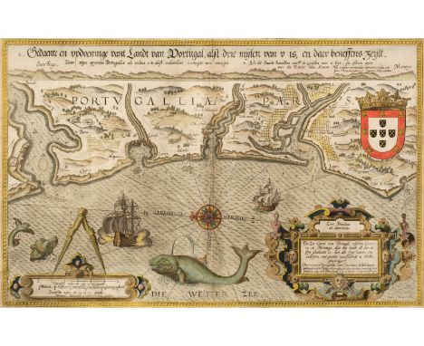
* Portugal. (Waghenaer (Lucas Janszoon), Die Zee Caerte van Portugal, tusschen Camino en Montego, alsoe dat Landt Alt daer in sijn Ghedaente is, met alle sijne Haeven enn Ondipten..., Leiden, circa 1586, hand-coloured engraved sea chart, orientated to the east, large strapwork cartouche and mileage scale, the sea decorated with a compass rose, sea monsters and sailing ships, 330 x 520 mm, mounted, framed and double-glazed, Latin text on versoQTY: (1)
Lot 128
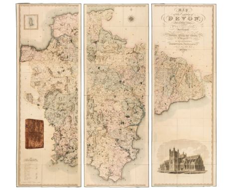
Devon. Greenwood (C. & J.), Map of the County of Devon from an Actual Survey, made in the Years 1825 & 1826 by C. & J. Greenwood, most Respectfully dedicated to the Nobility, Clergy and Gentry of the County, by the Proprietors Greenwood, Pringle and Co., February 20th, 1827, large scale engraved map on three sheets, sectionalised and laid on linen with contemporary wash colouring, inset map of Lundy Island, calligraphic cartouche, compass rose, table of explanation, uncoloured engraved vignette of the 'North West View of Exeter Cathedral', slight offsetting and spotting, each sheet edged in green silk (with slight fraying to the silk), marbled endpapers, each sheet approximately 645 x 1905 mm, contained in a contemporary calf book box with a contrasting red morocco gilt label to spine, some wear to the book boxQTY: (1)NOTE:Batten & Bennett. The Printed Maps of Devon, number 96.
Lot 132
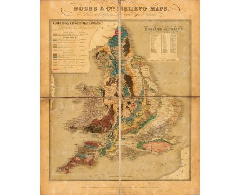
England and Wales. Dobbs & Co.'s Relievo Maps, Drawn & Engraved from the Highest Official Authorities. Geological Map of England & Wales. Arranged by permission from an Improved Index Map by R.I. Murchison Esqr. F.R.S. Resid, London: Dobbs & Co., [1843], folding geological relief map with contemporary hand-colouring, table of geological strata and reference table of English counties with vertical scale, pasted on boards, dissected and on linen, light surface wear and toning from varnish, pencil initials to lower margin, juvenile drawings to verso (some partially erased), folded into original blind stamped boards with gilt decoration to upper board, slightly faded, extremities rubbed, 550 x 450 mm QTY: (1)NOTE:Rare. Only 2 institutional copies (The British Library, The Geological Society).


Lot 294
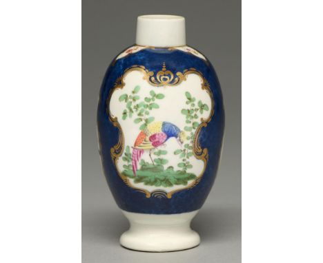
A Chinese famille rose miniature teapot or condiment ewer and cover with European-subject decoration, 18th c, of baluster shape, painted to either side with a corpulent European man and lady with a boy holding a coffee pot or another group of three figures in a landscape with pine trees or plantain, edged with black enamel scrolls on puce scale ground, the handle and spout gilt, 14cm h Localised wear, not cracked or chipped, no restoration

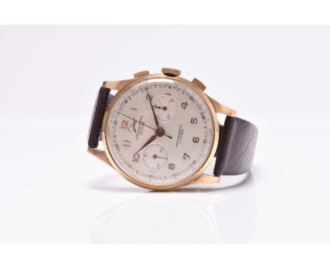
Lot 465
Javil: A gentleman's 18ct gold chronograph wristwatchModel: Chronographe SuisseDate: Circa 1950Movement: 17-jewel manual windDial: Silvered, applied Arabic hour markers, outer minutes trach and tachymeter scale, subsidiary dials for seconds and elapsed timeCase: Polished tonneau form, pull-out crown flanked by twin pushers, snap-on back and inner cover, stamped 18ct on backStrap/Bracelet: Associated brown leather strapBuckle/Clasp: Gold plated buckleSize: 37mmWeight: 44g grossCondition:Case and back: Micro-abrasions and tiny dints consistent with age and use. Plating worn on crown.Crystal: Fine abrasions throughout.Dial: A few very minor spots.Hands: Very minor tarnishing spots.Strap: Some signs of wear. Plating worn on buckle.Movement: Winds, sets and runs. Chrono hand doesn't return to 12 but 12.02. Elapsed time sub dial not functioning.Unless otherwise stated, all watches are likely to have been serviced and/or repaired in their lifetime and may have had parts replaced. While a watch may be described as 'working' at the time of the report, they are not guaranteed for timekeeping, mechanical durability or waterproofing (where applicable) - it is advised that all watches are inspected and serviced by a qualified jeweller or horologist before full use. The cost of servicing can be significant and so we strongly advise obtaining a quote before placing your bid.
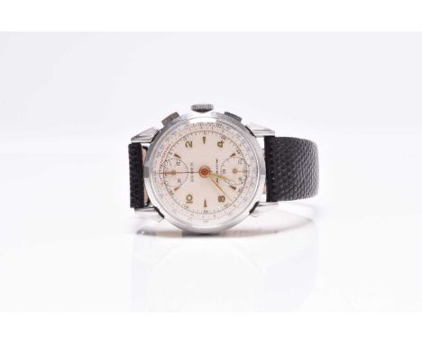
Lot 449
Buren: A gentleman's stainless steel chronograph wristwatch Date: Circa 1950 Movement: 17-jewel manual wind 'Venus 170' Dial: Silver, applied Arabic and baton hour markers, black outer minutes track, red telemeter scale, blue tachymeter scale, subsidiary seconds at 6, elapsed time dial at 12, gilt hands, red chronograph hand Case: Polished round form, moulded lugs, pull-out crown flanked by twin pushers, snap-on back stamped 6005B Strap/Bracelet: Associated black alligator Buckle/Clasp: Stainless steel buckle Size: 33mm Condition:Case and back: Minor scratches in places. Scratches to both pushers, wear to plating on upper pusher.Crystal: Fine micro-abrasions only.Dial: Good.Hands: Some tarnishing to the chrono hand.Strap: Good with only minor signs of wear.Movement: Winds, sets and runs. Chrono functions correctly.Accompaniments: None.Unless otherwise stated, all watches are likely to have been serviced and/or repaired in their lifetime and may have had parts replaced. While a watch may be described as 'working' at the time of the report, they are not guaranteed for timekeeping, mechanical durability or waterproofing (where applicable) - it is advised that all watches are inspected and serviced by a qualified jeweller or horologist before full use. The cost of servicing can be significant and so we strongly advise obtaining a quote before placing your bid.


Lot 55
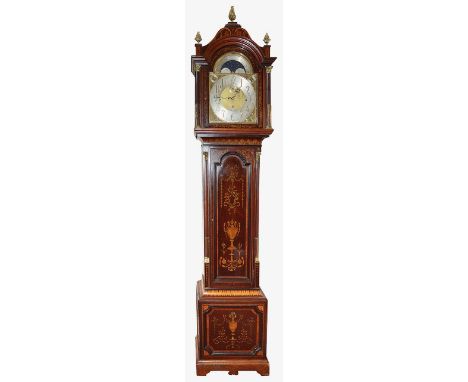
A late Victorian Sheraton Revival mahogany and marquetry long case clock with moonphase13" arched brass dial with silvered chapter ring with applied brass Arabic numerals, foliate engraved spandrels, moonphase to arch with with silvered calendar scale, subsidiary seconds dial, and chime /silent, Westminster Chimes, /Whittington Chimes selection dials, signed J. Smith & Sons, St Johns Square Clerkenwell, three train 1/4 striking brass movement striking on nine tubular gongs, with mercury jar compensated pendulum and three brass weights, the hood with a glazed door flanked by stop fluted gilt metal mounted Corinthian columns and pierced sound frets, fitted with a surmount with gilt brass pineapple finials, the trunk with conforming quarter engaged pilasters over a box base, all over with fine marquetry inlaid decoration of urns and swags height 265cm.Condition: Winds ticks and runs however no guarantee can be offered as to the full working order. Clock was in working order until disassembled for trasnport. Case keys and winding keys present. Case in good condition with shrinkage crack to surmount and right hand side of box base
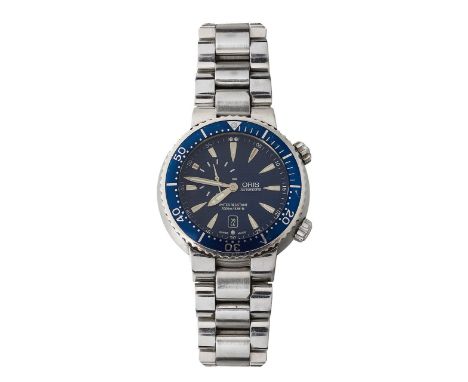
Lot 407
A gentleman's Oris stainless steel automatic Diver's wristwatch ref 7609circular blue wave with raised silver hour dagger markers with luminous inserts, subsidiary seconds dial between 9 and 12 o'clock, outer seconds in white, blue enamel fluted rotating bezel with tachymeter scale, stainless steel bracelet with deployment clasp signed Oris.dial diameter 38mm., case diameter 46mm.Condition: Runs, however no guarantee can be offered as to the full working condition. Surface wear and light scratches. Small scratch with loss to enamel on rotating bezel, other surface scratches to enamel


-
186097 item(s)/page