FOUR 1/18 SCALE LOTUS FORMULA 1 RACING CARS comprising an Exoto Lotus Ford 72E, 1973 (R. Peterson); Exoto Lotus Ford 72D, 1973 (R. Peterson); Minichamps Lotus Ford 79 (M. Andretti); and Corgi No.190, J.P.S. Lotus Formula 1; together with a 1/16 scale Schuco No.356 177, J.P.S. Lotus Formula 1, each mint or near mint boxed.
We found 186094 price guide item(s) matching your search
There are 186094 lots that match your search criteria. Subscribe now to get instant access to the full price guide service.
Click here to subscribe- List
- Grid
-
186094 item(s)/page
FOUR 1/18 SCALE LOTUS FORMULA 1 RACING CARS comprising a Quartzo Lotus 49B, 1968 U.S. Grand Prix (M. Andretti); Quartzo Lotus 49C, Winner 1970 Monaco Grand Prix (J. Rindt); Quartzo Lotus 72C, Winner 1970 U.S. Grand Prix (E. Fittipaldi); and Quartzo Lotus 72D, Winner 1972 British Grand Prix (E. Fittipaldi), each mint or near mint and boxed.
A LARGE 8-DAY EDWARDIAN BRACKET CLOCK with pull repeat mechanism, the silvered chapter ring with Roman hour markers and Arabic minutes, beneath 'Strike/Silent' and 'Westminster Chime/Chime on Eight Bells' dials, the case with brass Corinthian columns and fitted to the side with handles above fish scale grilles, 44cm wide 29cm deep 46cm high
A profusely carved 19th century Anglo-Indian hardwood side chair, circa 1860, Bombay region, arched top rail with centralised peacock to front and rear flanked by foliate trails, side uprights bearing scrolling vinery detail and surmounted with figural finials, back splat with male and female costumed dancers to front and foliate carving to reverse, the seat with central panel depicting a rural scene featuring two figures with oxen within a foliate frame with florettes, serpentine form friezes to front and sides bearing conforming carved design, front legs featuring stylised feline heads to upper sections, foliate carved shoulders above scale carved stylistic dolphin feet, 39in. (99cm.) high, 20in. (50.8cm.) wide.
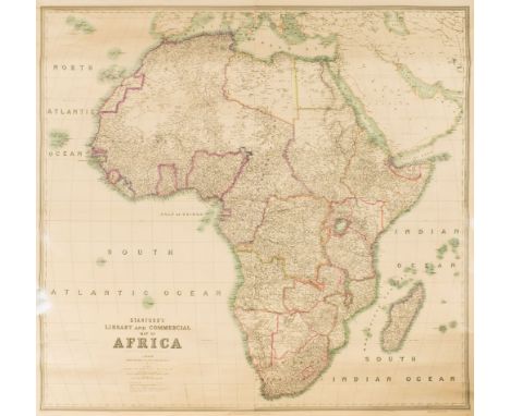
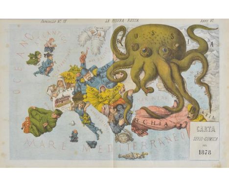
Le Perroquet, Journal Politique Charivarique IllustrÚ ColoriÚ, 2 volumes, 1876-77 & 1878-79, containing 8 issues of Il Papagallo between 1876 and 1877, and 120 issues of Le Perroquet from 6th August 1876 to 30 September 1879 (renamed The Parrot from 18 May 1879 onwards), each issue consisting of 4 pages, with a double-page colour lithograph by Augusto Grossi, all bound in two contemporary cloth bindings, blindstamped decoration to each cover, titled and dated in gilt to centre of each upper cover, slightly rubbed and frayed, and some inner hinges broken, folio (40 x 31.5 cm, 15.75 x 12.5 ins) Rare bound volumes of the satirical magazine Il Papagallo and its Parisian version Le Perroquet, founded in 1873, containing large-scale serio-comic caricatures in vivid colour by Augusto Grossi (1835-1919). Sold as a periodical, not subject to return. A list of the issues contained in these two volumes, including numbers and dates, is available from the auction office. (2)
Scotland. Ordnance Survey (publishers), Untitled map of the environs of Glasgow, 1872, large electrotype map with contemporary outline colouring, sectionalised and laid on linen, on a scale of one inch to the mile, slight staining, marbled endpapers, 1390 x 1260 mm, contained in a contemporary cloth slipcase, case stained and frayed (1)
Wales. Lhuyd (Humphrey, Ortelius Abraham), Cambriae typus auctore Humfredo Lhuydo Denbigiense Cambrobritano, [1592], uncoloured engraved map, large strapwork cartouche and mileage scale, very small hole to central fold, 370 x 500 mm, Latin text on verso Marcel van den Broecke. Ortelius Atlas Maps, no.21. (1)
England & Wales. Willdey (George), A new and correct map of England & Wales now called South Britain, done from the latest surveys and best observations. Containing all ye cities & market towns with ye roads & distance in reputed miles between town & town by inspection without scale or compass..., circa 1717, engraved map with contemporary outline colouring on two conjoined sheets, tables of towns and cities and eighteen uncoloured vignettes of principal cities to vertical margins, old folds and central fold strengthened on verso, slight tape staining at base of folds, 620 x 1010 mm R. W. Shirley. Printed Maps of the British Isles 1650 - 1750. Willdey 3. An uncommon distance map of England, based on the John Adams wall map of 1677. (1)
ORDNANCE SURVEY : a bound collection of 13 double-page large scale maps of Devon, scale, 25 inches to one mile, half cloth with attractive morocco title-label on the upper cover, large folio, 1890.* areas covered Holcombe Regis, Ashbrittle, Burlescombe, Culmstock, Uffculme, Grand Western Canal, etc.
Benjamin Cole - 5 loose City of London Ward Plans. 4 - 26 x 40cms., the other 40 x 38cms., some colour in coats of arms etc., ca. 1755 * large scale, with streets named & some individual buildings shown, includes Aldgate, Walbrook & Dowgate, Queen Hith-Ward and Vintry, Portsoken & Farringdon Wards; together with 2 old loose plans & a few loose prints.
ATLAS OF THE BOROUGH OF MANHATTAN, City of New York. Desk and Library Edition. 191 colour plans & 4 coloured index maps, with letterpress title & (4)pp. street index; rebound cloth with original gilt-lettered label on upper cover; oblong 4to. Philadelphia: G.W. Bromley & Co., 1921. * one of the most detailed of city atlases (scale: 160 feet to the inch), with individual buildings shown & many named. Illustrated
PORT OF LONDON AUTHORITY - Plan of Surrey Commercial Docks, 1968. 54 x 44cms., coloured, folded on linen within gilt-lettered board covers, scale: 400 feet to inch, reference key & 'police gate legend'. * from the Authority's operational office - 'estate officer's' copy (as lettered on cover), with properties sold / docks filled-in delineated & noted (1967-75) in red ink.
PORT OF LONDON AUTHORITY - Royal Victoria & Albert and King George V Docks, 1946. 57 x 91cms., coloured & folded on linen, scale of 400 feet to inch. * the usual detailed mapping, & as others, from the Authority's operational dept.; it is believed that buildings heavily coloured in red indicate wartime destruction - with others already having been rebuilt.
PORT OF LONDON AUTHORITY - Plan of the India & Millwall Docks, 1916. hand-coloured, 68 x 77cms., folded on linen, scale: 400 feet to inch. * much detail - dock acreages (as OS.) but also length, width, & depth (their entrances also), a reference key incl. for buildings (wood, brick, iron), shows Limehouse Ferry & Blackwall Tunnel.
-
186094 item(s)/page