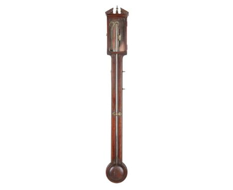
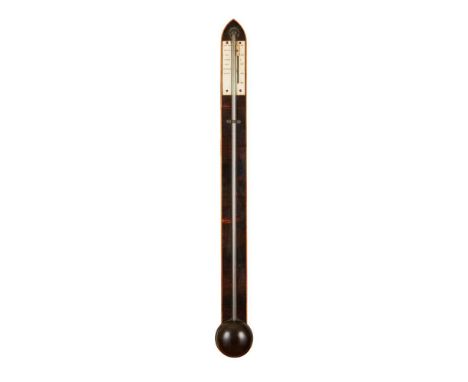
We found 185385 price guide item(s) matching your search

Refine your search

Year

Filter by Price Range
  • List
  • Grid
  • 185385 item(s)
    /page

Lot 1302

12 x Boxed and cased diecast models to include 2 x Corgi featuring CC86523 BMW Mini Cooper S, OM41701 RTW Double Decker Bus, 5 x Exclusive First Editions EFE featuring 2 x 31901 RML Routemaster, 31501, 15639 and 23318 AEC RF bus, 2 x Creative Master, 3 x Britbus and 3 x Hornby N Gauge scale resin models to include N8748 Mason's Arms Pub, N8076 Country Post Office and N8701 Country Police Station, models in VG condition, boxes in overall fair condition

Lot 1327

A collection of 11 boxed model vehicles to include Oxford 1/76 scale MGB, Union Jack Austin Min and a Jaguar E-Type together with a quantity of military vehicles and a Flying Scotsman 3D Puzzle.

Lot 1333

Boxed Corgi CC99130 1;50 scale Scotland's Finest -Pollock (Scotrans) LTD. Musselburgh, model in VG condition, box showing some wear but in GD condition overall

Lot 1337

Approx. 100+ loose diecast models to include Corgi, Matchbox, Majorette, Tonka, Burago, Maisto featuring 1:18 scale Jaguar S-Type (1999), etc (2 boxes)

Lot 1421

Boxed Britains 9745/8 155mm. Breech Loading Gun, containing presentation display stand and one shell casing, model in GD condition with tatty box, plus boxed Airfix HO/OO scale Gun Emplacement Assault Set, appearing complete but unchecked (2)

Lot 1427

Boxed 1:24 scale Danbury Mint The James Bond 007 Aston Martin DB5 in silver with certificate, model showing some signs of wear

Lot 1428

Boxed CMR Classic Replica Model 180 diecast model Jaun Manuel Fangio Maserati 250F 1957 Winner GP Monaco 1/18 scale, excellent

Lot 1429

Boxed CMR Classic Replica Model 162 diecast model Mike Hawthorn Ferrari Dino 246 F1 #6 1/18 scale, excellent

Lot 1430

Boxed Sun Star 1;12 scale 1960 Morris Mini Traveller diecast model in pale blue, model in VG condition with certificate, box shows some wear but in GD condition overall

Lot 1432

Boxed Spark Models Minimax 18S149 1:18 scale Porsche 911 GT3 RSR No.67 LM 2104, model in good condition but missing spoiler, tear to end flap

Lot 1458

Cased / Boxed 1:43 Matrix Scale Model MX51705-211 1947 Rolls Royce Silver Wraith, ltd edn 036 of 408

Lot 1465

Eight kit built BRS HO scale flat bed trucks/lorries, all white metal/diecast

Lot 374

A Fujimi 1/76 scale world armor series n0-11 set, with sidecar, in cellophane, boxed; other lead miniature figures, paints, enamels, part and incomplete sets, some painted, miniature modelling equipment, etc

Lot 445

Matchbox 1:32 scale PK1001 Counter Attack play kit, comprising various pieces including armoured car, various combat troops, cardboard play mat, other various parts and accessories, boxed

Lot 1089

A Louis Surber Renault Sport FRI bus 1:43 scale - boxed

Lot 1093

A Sun Star limited edition The Original Routemaster (double decker) bus 2901: RM8-VLT 1:24 scale - boxed

Lot 127

GB & Br C'wealth: Three pocketed A4 folders (60 leafs total) full of UMM QEII defin and commem stamps. These incl GB pre-decimal/early decimal in folded sheets, half sheets & blocks, with traffic lights/colour plate legends, plus Malta Christmas 1987 full sheet of 72 sets se-tenant and some Bermuda 1964 Olympics 3d. Total of 15+ full sheets seen, incl Investiture of Prince of Wales 1969 5d se-tenant of Caernavon Castle. Radar broken scale variety SG752a Cat £45 noted. GB decimal FV c £40.

Lot 177

A 'Thin' Black-Chrome Leitz Wetzlar Elmar 9cm f/4 Lens, serial no 320702, 1936, barrel P-F, brassing, faded aperture scale, elements F, haze, slight fungus with maker's black front cap

Lot 336

An Asahi Pentax Spotmeter V Light Meter, powers up, meter responsive, body G, some scratches, missing scale illuminating button from handle, elements G, in Pentax case

Lot 36

A Zeiss Ikon Miroflex B SLR Plate Camera, model 859/7, format 9 x 12cm, later model with leather covered front and a Carl Zeiss Jena Tessar 15cm f/4.5 lens, serial no 900122, shutter not working, modified with an improvised aperture scale, body P

Lot 55

Ernemann Bob 00 and Goerz Roll Tengor Folding Cameras, a Bob 00, 8 x 10.5cm on roll film, body G, adapted for 120 roll film, paper label replacement focusing scale, 3-speed shutter working, Ernemann Detectiv Aplanat f/6.8 lens F-G, edge haze, a Goerz Roll Tengor, 6 x 9cm on roll film, body F, Goerz shutter working, Goerz Kalostigmat 10cm f/6.8 F, haze, together with a Franka Solida 6 x 6cm folding camera with a Compur Rapid shutter working and a Rodenstock Trinar 7.5cm f/3.5 lens F-G, haze

Lot 79

A Kowa 2x Anamorphic for Bell & Howell Lens, serial no 0778073, 54mm diameter approx thread to mount on projection lens, focusing scale for 5 ft to infinity, barrel VG, elements G, edge haze, dust, with front cap

Lot 619

A metal cased Thermograph and a Salter vintage scale (2) Condition Report: Available upon request

Lot 123

A German Third Reich K98 Mauser Bayonet, retaining much of its original bluing, the blade with serial number 3001 to one side of the ricasso, the opposing side dated '41 and with maker's mark asw, with diagonally ribbed bakelite grip scales, the pommel and button catch with waffenamt markings, the blued steel scabbard stamped S/185G and 9491/C Footnote:- brought back from the war in Europe by 14569354 Spr. Ellis Brook who served with various regiments during and after the war. He was wounded whilst serving with the Cameron Highlanders in Western Europe. Fine rust pitting to pommel, two incised scratches to one grip scale. Scabbard has differing numbers and a dent to one side.

Lot 145

A 'Minic' scale model clockwork 'Ford light Van,' by Lines Bros, with original box and key, vgc

Lot 265

A die-cast scale model of the "Evening Star", 13 3/4" wide, and a similar scale model of the "Flying Scotsman", both in acrylic cases on wooden stands

Lot 360

Victorian portable trolley scales, class III to weight 55lb retailed by Bastick and two hanging balance scale beams. (3)

Lot 350

Australasia. Cook (Capt. James & Benard Robert), Carte d'une Partie de la Mer du Sud Contentant les Decouvertes de Vaisseaux de sa Majesté le Dauphin, Commodore Byron, la Tamar, Capitne. Mouats, 1765, Le Dauphin, Capitne. Wallis, le Swallow, Capitne. Cartaret, 1767, et l'Endeavour, Lieutenant Cook 1769, [1774], uncoloured engraved chart of the Southern Pacific Ocean, originally published in a French edition of 'An Account of the Voyages..., in the Southern Hemisphere' old folds, some staining, 360 x 665 mm, together with Le Perouse (Comte Jean de). Carte d'une Partie du Grande Océan a l'E et S.E. de la Nouvelle Guinee..., 1781, uncoloured engraved chart, showing the coastline of North-Eastern Australia, New Guinea, Fiji, Samoa & Tonga, slight creasing, some water staining but confined to the margins and not affecting the printed image, 345 x 495 mm, with Reinecke (Johann Matthais Christoph). Charte von Australien Berichtigt im November 1812, Prague, 1815, engraved map with contemporary outline colouring, old folds, slight staining, three very small holes where old folds cross, bound with eleven uncoloured engravings of Australasian mammals, birds, native costume and costume, several with long closed tears, plus an untitled map of Australia (part of a large scale map) with contemporary outline colouring, with two inset maps of King George III Sound and The Discoveries made by the Ship Duke on the Southern extremity of New Holland, 1791, slight creasing, 430 x 605 mmQty: (4)

Lot 356

Australia. Slater. (T.), Contour Map of Mornington Peninsula, Melbourne, 1891, uncoloured lithographic map on a scale of 1 inch to the mile, old folds, some staining and dust soiling, small ink library stamp, laid on linen and backed with an early 20th-century colour lithographic map of Northern France, Luxembourg and the Low Countries, 750 x 990 mmQty: (1)

Lot 363

British Isles. Custodis (David), Angliae, Scotiae et Hiberniae Britannicarum Insularum, Frankfurt [1627], uncoloured engraved map, orientated to the east and decorated with a strapwork cartouche, mileage scale and a compass rose, slight creasing, 270 x 315 mmQty: (1)NOTESR. W. Shirley. Early Maps of the British Isles, 396. A rather naive map by the little known David Custodis which appears to be based on Abraham Ortelius's map of 1570. The map appears in 'Laurea Austrica..., Typus Erasmi Kempffen'.

Lot 366

British Isles. Hondius (Henricus & Le Roy Henry), Novissima Descriptio Angliae, Scotiae et Hiberniae [with additional imprint] A Paris chez Michael van Lochon graveur et Imprimeur du Roy Henry Le Roy fecit, Paris [1639], hand-coloured engraved map, inset map of the Orkney Islands, large decorative cartouche and mileage scale, slight mount staining, margins slightly chipped, 380 x 510 mm, no text on the versoQty: (1)NOTESR. W. Shirley. Early Printed Maps of the British Isles, 493. A rare map, engraved by Michel von Lochom. The map appears to have been a separate publication and is only occasionally found in composite atlases. We have found records of only two copies, one in the British Library and one in the Bibliothèque Nationale.

Lot 379

Durham. Hobson (William Colling), This Map of the County Palatine of Durham is most respectfully dedicated to the Nobility, Clergy, Gentry &c. &c. By their most obliged and very humble servant, circa 1840, large scale engraved map with bright contemporary hand -colouring, sectionalised and laid on linen, calligraphic cartouche and table of explanation, slight offsetting, 775 x 1005 mm, bound in contemporary gilt green morocco boards with a fairly crude but near-contemporary morocco rebackQty: (1)

Lot 391

Folding Maps. A collection of seven maps, mostly 19th century, including Cruchley (G. F.). Cruchley's (Late Cary's) New Map of Ireland, showing Railways and all the Turnpike Roads with the Rivers and Canals..., circa 1845, engraved map with contemporary outline colouring, sectionalised and laid on linen, calligraphic title and table of explanation, 760 x 640 mm, tartan endpapers with the bookplate of J. Stewart Robertson, contained in a contemporary cloth slipcase with publishers' printed label to upper cover, slipcase a little faded and worn at extremities, together with Cary (John). Cary's New Map of Ireland Exhibiting the whole of the Turnpike Roads with the Rivers and Canals..., 1832, engraved map with contemporary outline colouring, sectionalised and laid on linen, slight offsetting, 760 x 640 mm, chalk endpapers, contained in a contemporary card slipcase with publisher's printed label to the upper cover, slight wear at extremities, with Walker (J. & A.). To Lieut. General The Most Honble. the Marquis of Anglesey, K. G. G. C. B..., This Map of North Wales is with his Lordship's permission most respectfully dedicated..., circa 1845, engraved map with contemporary outline colouring, sectionalised and laid on linen, calligraphic title, engraved vignette of the Menai Bridge, slight staining and dust soiling, near-contemporary ink ownership signature to the upper margin, 625 x 770 mm, cloth endpapers, blind-stamped cloth binding with gilt publisher's stamp (Letts Son & Co.) to upper cover, faded and frayed along the spine, plus Cary (John). Cary's Reduction of his Larger Map of England and Wales with Part of Scotland..., 1805, engraved map with contemporary outline colouring, sectionalised and laid on linen, 760 x 630 mm, contained in a card slipcase with circular publisher's label to upper cover, slipcase heavily worn and frayed, and Laurie (Robert & Whittle James). A New Map of Scotland or North Britain, Drawn from the most approved Surveys..., 1794, engraved map with contemporary outline colouring, sectionalised and laid on linen, inset map of the Shetland and Orkney Islands, slight staining, 570 x 525 mm, with Ordnance Survey (publishers). Map of Neath, Edward Stanford, circa 1860, engraved map with contemporary outline colouring, sectionalised and laid on linen, scale 1 inch to the mile, 970 x 1430 mm, contained in a contemporary cloth slipcase with publisher's printed label to upper cover, slipcase stained and a little frayed, and plus a folding map of Argyleshire by John Johnstone and W. & A. K. Johnston and House of Commons Commissioners (publishers). Sixth Report of the Commissioners for Roads and Bridges in the Highlands of Scotland, 24th February 1813, title page and 45 pages of text, including an engraved plate of an elevation and plans of the Bonar Bridge and an engraved folding map of Scotland by A. Arrowsmith, contemporary outline colouring, map size 610 x 500 mm, contemporary blue paper wrappers with printed titles to both sidings, and a 20th-century book box, the covers decorated with a reproduction of H. Hondius's map of the word, 255 x 175 mmQty: (9)

Lot 394

France. Sanson (Nicolas ), Carte Particuliere des Postes de France, Pierre Mortier, Amsterdam, circa 1710, engraved map on two sheets with contemporary outline colouring, decorative allegorical title cartouche, with two other cartouches containing the mileage scale and a key plate, very occasional marginal closed tears, each sheet approximately 330 x 615 mmQty: (2)

Lot 397

Glamorganshire. Saxton (Christopher), Glamorg? comitatus australis Cambriae pars descriptio Ano Dni 1578 [1579], engraved map with contemporary hand-colouring, large strapwork cartouche surmounted by the arms of Elizabeth I, the scale of miles surmounted by dividers, decorated with the coat of arms of Thomas Seckford, very slight staining, 335 x 490 mmQty: (1)NOTESThe first printed map of Glamorganshire, with the 'bunch of grapes' watermark.

Lot 405

Leicestershire. Blaeu (Johannes), Leicestrensis Comitatus. Leicester Shire, Amsterdam, circa 1645, engraved map with contemporary outline colouring,385 x 500 mm, Dutch text on verso, together with Saxton (Christopher & Kip William). Lecestriae Comitatus sive Leicestershyre pars olim Coritanorum, circa 1610, hand-coloured engraved map, strapwork cartouche and mileage scale, some mount staining, thread margins on the vertical borders, 285 x 360 mm, with three other maps of Leicestershire, by Moule, Fullarton and Langley, various sizes and conditionQty: (5)

Lot 409

London. Cruchley (G. F.), Cruchley's New Plan of London Shewing all the New and Intended Improvements to the Present Time [1827], uncoloured engraved folding map, a few sellotape repairs to verso, 425 x 570 mm, bound in the rear of 'Cruchley's Picture of London, or Visitor's Assistant', 235 pages of descriptive text and a 30-page catalogue of 'General & County Atlases', contemporary cloth gilt with a contemporary printed title label to the upper siding, 8vo, together with J. Reynolds & Sons (publishers). Waistcoat Pocket Map of London showing the Streets, Railways & Stations, Omnibus Routes, Public Buildings, Parks &c. circa 1880, folding lithographic map laid on linen, contemporary hand colouring, map size 410 x 550, bound in contemporary cloth boards with printed label to the upper cover, binding size 90 x 60 mm, with Bacon (G. W. publisher). Bacon's Large Scale Plan of the City of London, circa 1950, folding colour lithographic map laid on linen, 420 x 680 mm, bound in the publisher's printed card wrappers with a map of the Underground on the rear cover, binding size 175 x 110 mmQty: (3)NOTESThe first described item: J. Howgego, The Printed Maps of London 307 state 1.

Lot 415

Monmouthshire Saxton (Christopher & Web William), Monumethensis comitatus Regis Henvici quinti natalitiis celeberrimus Ano Dm 1642 uncoloured engraved map, decorative cartouche and mileage scale, 395 x 485 mmQty: (1)NOTESA rare 'civil war edition' of Christopher Saxton's map of Monmouth by William Web. Originally published in 'The Maps of All the Shires in England and Wales'.The arms of Elizabeth I have been replaced by those of Charles I, and apart from the change to the date very few other alterations have been made. In very good condition.

Lot 422

Pembrokeshire. Saxton (Christopher), Penbrok Comitat qui inter Meridionales Cambriae..., 1579, engraved map with contemporary hand-colouring, large strapwork cartouche surmounted by the royal crest, mileage scale surmounted by dividers and the coat of arms of Thomas Seckford, slight staining, remains of old but later linen guard on verso, 355 x 465 mmQty: (1)NOTESThe first printed map of Pembrokeshire with the 'bunch of grapes' watermark.

Lot 428

Portugal. Homann (Johan Baptiste), Regnum Portugalliae Divisum in quinque et Provincias majores..., 1736, engraved map with contemporary hand colouring, large decorative cartouche, 605 x 470 mm, together with Bowles (Carington). An Accurate Map of Portugal laid down according to Sr. Nolin, 1771, engraved map with contemporary hand-colouring, decorative cartouche and compass rose, laid on linen, three punch holes to the upper margin but not affecting image, 660 x 480 mm, with De Wit (Frederick). Novissima Regnorum Portugalliae et Algarbiae Descriptio..., Amsterdam, circa 1688, engraved map with contemporary outline-colouring, decorative cartouche and mileage scale, some creasing and staining, occasional marginal closed tears, central fold partially repaired on verso, 590 x 490 mm, plus Weigel (Christopher). Portugallia ex Descriptione Exactissima Eduardi Nonii Verandi Alvari Secci et Antonii Vasconcelli Delineata, Nuremberg, circa 1719, engraved map with contemporary outline colouring, large uncoloured cartouche, central fold repaired on verso and slightly stained, 405 x 335 mmQty: (4)

Lot 436

Scotland. Ordnance Survey, Maps nos. 1 - 131 (complete), bound in 2 volumes, Ordnance Survey Office, circa 1900, tipped in key plate to volume 1, 131 uncoloured photo-lithograph maps on a scale of 1 inch to a mile, occasional marginalia and later crude outline colouring, some dust and finger soiling throughout, key plate to the front pastedown of each volume, some maps trimmed at the base, a few with an Ordnance Survey office blind stamp to the lower right corner, a few maps split along central fold, a few maps with marginal fraying and tears, seven index maps bound at the rear, later endpapers, modern cloth with gilt cloth labels to the upper sidings, a little bumped, large folio, together with Ordnance Survey (publishers). Ordnance Survey Atlas of Scotland, Quarter Inch to the Mile, Southampton, 1924, title, index and table of explanation, 18 colour printed double-page maps, each laid on linen, index bound at rear, later endpapers, modern red quarter morocco gilt over marbled boards with a gilt vellum title label to the upper cover, oblong folio, (355 x 400 mm)Qty: (3)

Lot 437

Scotland. Visscher (Nicolas), Exactissima Regni Scotiae Tabula tam in Septentrionalem et Meridionalem..., Amsterdam, circa 1680, engraved map with contemporary hand colouring, decorative cartouche and mileage scale, central fold strengthened and repaired on the verso, slight overall toning, 570 x 480 mmQty: (1)

Lot 445

Surrey. Schenk (P. & Valk (G.), Surria vernacule Surrey, circa 1700, engraved reticulated map with contemporary outline colouring and some later enhancement, decorative cartouche and mileage scale, slight mount staining, 380 x 495 mmQty: (1)

Lot 604

Harland (W. B. et al). The Phanerozoic Time-scale, a supplement, 1st edition, London: Geological Society of London, 1971, original cloth in dust jacket, covers rubbed & lightly marked, 8vo, together with; Smith (Reginald A.), The Sturge Collection...of Flints, 2 volumes, London: British Museum, 1931-37, colour & black & white illustrations, publishers original red cloth, spines lightly faded & rubbed, 8vo plus other modern archaeology & history reference, including publications by Oxford, Batsford, Cambridge, mostly original cloth, many in dust jackets, some paperbacks, G/VG, 8vo/folioQty: (6 shelves )

Lot 163

An early Salter cast iron 200 lb weighing scale, L. 60cm

Lot 277

A handmade row of dolls house scale shops, W. 153cm. H. 36cm. With contents.

Lot 215

Burago 1/18 scale Porsche 911, Welly 1/24 scale Porsche Boxter, Dinky 651 Centurion Tank, Corgi 007 Aston Martin, others (14) and plastic Army Troopers

Lot 147

A Corgi Classics James Bond Collection die cast model Stromberg helicopter and Naomi figure set, boxed, together with a Vanguards die-cast 1:43 scale replica Ford Anglia, and a Matchbox SuperFast VW Concept 1 model motor vehicle, both boxed

Lot 511

JOHN SPEED (1552-1629), "The West Riding of Yorkshire .... 1610", hand coloured engraved map, with title cartouche, plan of York City, figural scale and arms of the Royal Princes, text to reverse, 14 3/4" x 19 3/4", Hogarth frame (Est. plus 21% premium inc. VAT)Generally very good, some creasing to top left corner colouring neatly done and vivid, no staining, margins possibly damaged/cut as mount is close to image

Lot 512

JOHN SPEED (1552-1629), "Shropshire", hand coloured engraved map with title banner, plan of Shrowesbury (sic), scale cartouche and sketch of the Battle of Shrewsbury, text to reverse, 15 1/4" x 20 1/2", gilt frame (Est. plus 21% premium inc. VAT)Generally good, no tears/creading/staining, perhaps some very faint foxing top right corner (?)

Lot 513

JOHN SPEED (1552-1629), "Cambridge Shire", hand coloured engraved map with title cartouche surmounted by the Royal Arms, plan of Cambridge, Arms of the Royal Princes and Colleges and figural scale, text to reverse, 15 1/4" x 21", Hogarth frame (Illustrated) (Est. plus 21% premium inc. VAT)Very good condition

Lot 514

JOHN SPEED (1552-1629), The North and East Ridings of Yorkshire, hand coloured engraved map with title cartouche, plans of Richmond and Hull, figural scale and arms of the noble families, 15 1/2" x 20 1/2", Hogarth frame (Est. plus 21% premium inc. VAT)No foxing/creasing/tears, mildy stained brown - no margin showing

Lot 515

JOHN SPEED (1552-1629), Northumberland, hand coloured engraved map with title cartouche, plans of Berwick and Newcastle, scale and arms of Noblemen, 15 1/4" x 20 1/4", Hogarth frame (Est. plus 21% premium inc. VAT)Generally good, only top margin showing and small hole to centre of same, some creasing towards the lower end centre, small stain just above "wall" of "the picture? wall"

Lot 516

JOHN SPEED (1552-1629), "Gloucestershire", hand coloured engraved map with title cartouche, Royal and Noble arms, plans of Gloucester and Bristol and scale, text to reverse, 15" x 24", Hogarth frame (Illustrated) (Est. plus 21% premium inc. VAT)Generally very good, no tears, foxing, staining, margins clear and good

Lot 517

ROBERT MORDEN (c.1650-1703), "Westmorland", hand coloured engraved map with title cartouche and scale, 14 1/4" x 16 1/2", together with another similar "Cumberland", 14 1/4" x 16 1/2", both framed (2) (Est. plus 21% premium inc. VAT)Westmorland - mild foxing, otherwise good, very little margin showingCumberland - generally very good, odd very mild stain spots, small crease lower left corner near "Ocean"

Lot 518

ROBERT MORDEN (c.1650-1703), "Northumberland", hand coloured engraved map with title cartouche and scale, 16 1/4" x 73 3/4", together with another similar "Durham", 14 1/4" x 16 1/2", and John Speed (1552-1629) Map of Durham with title banner, Royal Arms, plan of Durham and compass rose, 15" x 19 3/4", all in Hogarth frames (3) (Est. plus 21% premium inc. VAT)Northumberland very mild brown staining throughout and very slight creasing to right side edge, otherwise goodDurham - very mild brown staining and mild creasing - not quite flatDurham (Speed) brown staining throughout bar centre fold, mild creasing on left side edge

Lot 519

ROBERT MORDEN (1650-1703), The North Riding of Yorkshire, The East Riding of Yorkshire and The West Riding of Yorkshire, set of three hand coloured engraved maps with title cartouche and scale, 14" x 16 1/2", framed (Est. plus 21% premium inc. VAT)North and East - very goodWest - brown staining especially along centre fold, mild creasing and small tear lower right corner

Lot 520

JOHN SPEED (1552-1629), Cumberland , c.1627, hand coloured engraved map with title cartouche, map of Carlisle, scale, an account of "The Picts Wall and Arms of the Earls of Carlisle, text to reverse, 14 3/4" x 19 3/4", stained frame, together with a Robert Morden (1650-1703), Map of Shropshire, 14 1/4" x 16 1/2", Hogarth frame (2) (Est. plus 21% premium inc. VAT)Speed - Generally good, no foxing, very mildly brown stained, small tear at base of centre fold, margins goodMorden - perhaps some fading, otherwise good

Lot 522

NICHOLAS VISSCHER (1618-1709), "Hiberniae", hand coloured engraved map, c.1690, with title cartouche and scale with Royal Coat of Arms, 23 1/2" x 20", gilt frame (Est. plus 21% premium inc. VAT)Small hole and tear in County Cork West of Kinsale, tear in centre West of Kildere, otherwise good

Lot 79

ITALIAN SCHOOL, ATTRIBUTED TO MICHELE ROCCA (1671-1751) Madonna and Child Oil on canvas, 60 x 69cm Originally from Parma, where Correggio was a primary influence, Michele Rocca traveled to Rome in 1682 and trained under a follower of Pietro da Cortona. Five years later he was back in Parma, but by 1695 he had returned to Rome. Rome's artistic environment provided Rocca with the major elements of his style. Under Sebastiano Conca's influence, Rocca painted works that are often mistaken for Conca's. Conca’s elegant, sweet manner also inspired Rocca; through him, Rocca may have met French painters working in Rome and by the 1720s Rocca's paintings displayed the languorous eroticism and fashionable chic of the French Rococo. His Clemency of Scipio (c. 1720; Rome, Private Collection) relies heavily on Conca’s Antony and Cleopatra, while the shared dimensions of the two paintings (87×135 cm) have suggested to some that they were executed as pendants. In 1710 Rocca was elected to the Congregazione dei Virtuosi al Pantheon, and about the same time he executed two of his best-known paintings: the Toilet of Venus (Providence, Museum of Art) and the Finding of Moses (Univeristy of Chicago, Smart Museum of Art). These are among the finest of the small-scale, semi-precious cabinet pictures of mythological and hagiographical subjects that dominate Rocca’s oeuvre and gained for him the reputation of being a petit maître in early 18th-century Rome. Their decorative rarity, luminous pigmentation and rich painterly effects betray the fundamentally sensual nature of Rocca’s style and clearly suggest that his artistic vision was in some ways more closely aligned with the emerging French Rococo than with the neo-Baroque style of his contemporary Roman colleagues. Works by Rocca are represented in the following collections: J Paul Getty Museum, Los Angeles; Louvre, Paris; Museu de Arte de Sao Paolo; Smart Museum of Art, University of Chicago, amongst others.

Loading...Loading...
  • 185385 item(s)
    /page

Recently Viewed Lots